Pollen analysis is one of the environmental proxies useful for quantitative reconstruction of paleoecology and paleoclimate, and the establishment of a quantitative relationship between surface pollen and vegetation is crucial for accurate interpretation of paleoecology and paleoclimate from fossil pollen. In this study, to explore the relationships between surface pollen assemblages and vegetation and altitude, 113 samples of modern surface pollen and moss were collected from the vertical vegetation zones in central south subtropical China. Based on the results of Canonical Correspondence Analysis (CCA), the study revealed the connections between the distribution of pollen taxa at different elevations and with various climate factors. The main results are as follows: 1) Castanopsis, Quercus-evergreen, Pinus, Cunninghamia and Euphorbiaceae were the dominant pollen taxa of the arbors, and Poaceae, Artemisia, Compositae, and Cyperaceae were the main components of the herbs. Trilete, Dicranopteris, Polypodiaceae and Monolete accounted for a high percentage of the fern pollen. 2) The relationships between pollen taxa and altitude could be divided into three patterns: Castanopsis, Quercus-evergreen, Pinus, Mallotus, Liquidambar, Rubiaceae,and Poaceae were common at the low altitudes (0-702 m). In the medium altitude area (703-1,299 m), there were significant pollen contents in Castanopsis, Cunninghamia,Pinus, Quercus-evergreen, Ericaceae and Pinus. The higher altitude area, at around 1,300-1,600 m, was dominanted by Castanopsis, Quercus-evergreen, and Fagus. Therefore, the distribution of surface pollen is consistent with that of modern vegetation. 3) The results of CCA showed that the climate factors controlling the distribution of surface pollen were Mean Annual Precipitation (MAP), Mean precipitation of warmest season (Mpwa), and Mean temperature of warmest season (Mtwa). It was obvious that the climate characteristics corresponded to high percentage values of various pollen, such as Pinus, Cunninghamia, Castanopsis, Quercus-evergreen, Theaceae, Fagus, and Quercus-deciduous. 4) The significant taxa of Castanopsis, Quercus-evergreen at lower elevations and Pinus, Cunninghamia and Fagus where grow at relatively high area can reflect the effects of climate factors on the spatial distribution of vegetation. Therefore, the results of this study indicated that the surface pollen assemblage varies significantly through the vertical vegetation zones in central south subtropical China. The characteristics of surface pollen dispersal were greatly influenced by the vegetation composition in the region, the habitat, pollen morphology, and the pollen transmission process, which provides a crucial reference for quantitative reconstruction of paleoecology and paleoclimate from fossil pollen data in a subtropical region.
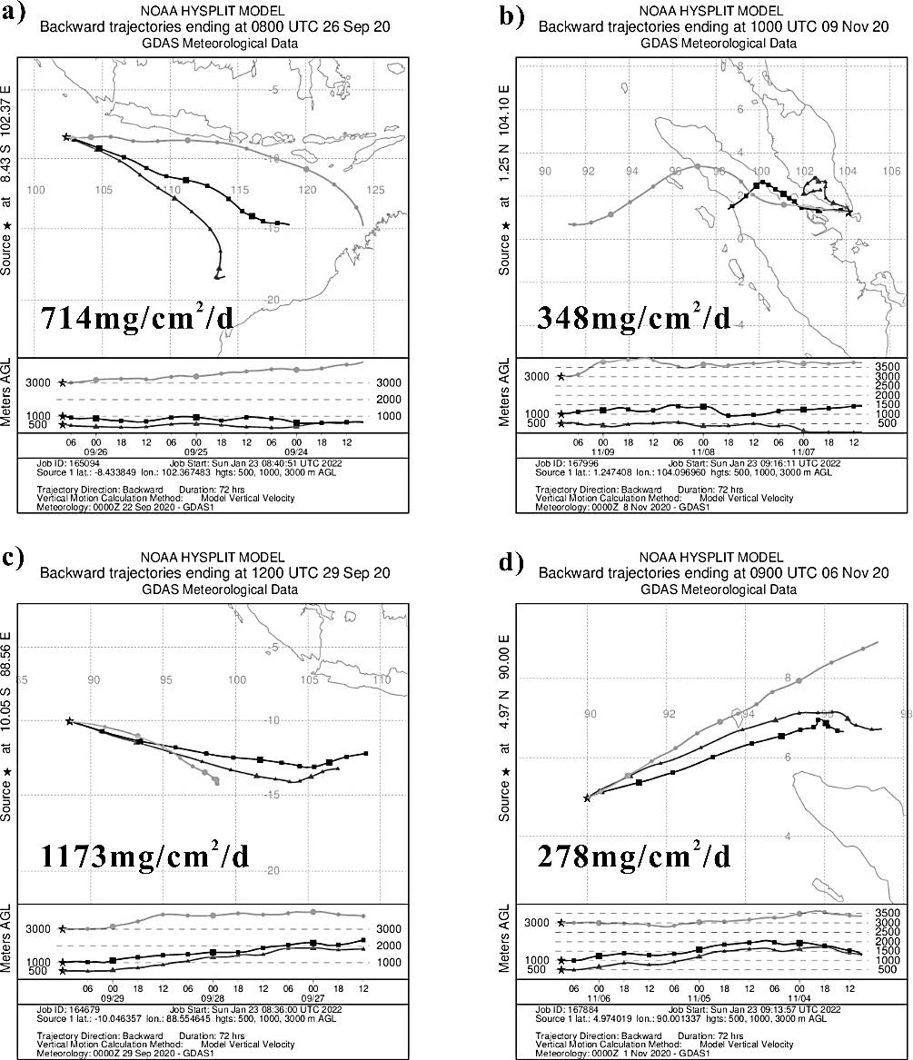
Atmospheric dust in the ocean is a bridge for air-sea interaction, which is an important basis for the study of this phenomenon due to extensive and observable space-time scales. The northeast Indian Ocean, located in the southern wing of the "roof of the world," the Tibetan Plateau, is among the seas with the strongest marine productivity and richest biodiversity in the world. However, there have been no relevant reports on the study of modern marine dust. This study discussed the modern process of atmospheric dust deposition in the northeast Indian Ocean for the first time, in terms of deposition flux, transport path simulation, scanning electron microscopy, and energy spectrum analysis based on atmospheric dust samples collected from September to November 2020 in the study area. The findings showed that the dust deposition flux in the northeast Indian Ocean varied between 221-1,221 mg/cm2/d. The maximum daily dust deposition fluxes appeared in the middle of November when winter monsoon conditions prevailed, and the minimum value appeared in late September under summer monsoon conditions; the former flux was approximately six times that of the latter. The dust deposition flux change was primarily affected by the distance of the dust source, whereas the dust particle size was related to wind intensity. The results of air particle simulation indicate that the dust transport process is controlled by seasonal and regional atmospheric circulation systems, and is specifically dominated by the Indian monsoon in the northeast Indian Ocean. The study area deposits more dust with nutrient elements from the Asian continent, which promotes the ocean's primary productivity and enhances its carbon sequestration capacity. Furthermore, the surface of quartz particles from modern atmospheric dust shows a unique structure in the aeolian environment, good quartz grain roundness, a meander ridge, and a U-shape. These characteristics are markedly different from those in a fluvial condition, such as poor roundness, conchoidal fracture, and a V-shape, which can be used as a reference to distinguish the different continental components in the sediments in the hope of establishing winter monsoon proxies in the northeast Indian Ocean to reconstruct the evolution of the Indian monsoon. This study not only fills a gap in the present-day dust deposition process in the northeast Indian Ocean but also provides new insight for dust research in the study area, with great scientific significance for the study of air-sea interaction and carbon sinks in the ocean, and ideal indicators for reconstructing the evolution of the paleo-Indian monsoon and changes in the paleo-ocean environment. Moreover, it offers important information for the reconstruction of the historical evolution and dynamic mechanism of the ancient Indian monsoon.
Educational activities have obvious influence on the development of social space, which has always been an important topic of theoretical and practical research. In China, with urban economic development and social transformation, the differentiation of residential space caused by differentiation of educational resources is becoming more pronounced. School-district communities in many central cities, especially the high-quality school-district communities in old urban areas, with a strong contrast between high housing price and dilapidated material landscape, high-quality education and poor living environment, have a strong pulling and tearing effect on the value orientation and social practice of individuals, families, and communities. This has become one of the most typical spaces of social-spatial contradiction and distortion. This study introduces the concept of "alienation" (a philosophical term) and investigates the social-spatial characteristics and mechanism of high-quality school-district communities, from the theoretical viewpoint of "social-spatial dialectical unity." Taking Nanjing as an example, a survey reveals that a large proportion of the high-quality school-district community is old and dilapidated. Hence, the contrast between their material space and social value is significant, the housing price is at an irrational premium, the educational function surpasses the residential function and becomes the primary function of the community, and residents construct a non-geographical social network and shape an education community neighborhood. The high-quality school-district community in Nanjing exhibits the characteristics of social-spatial alienation, which is common and significant. This study further analyzes the mechanism of alienation, which is logically related to external factors such as housing market reform, school district, and oriental culture. However, in essence, the social-spatial alienation is the result of the impact on the dialectical unity of society and space, displaying the tendency of separation and opposition, which promotes the self-denial and role evolution of the community of "high-quality school-district housing". The social-spatial alienation will lead to many negative effects. It will lay siege to the school district and aggravate the antagonistic effect of society and space. It will trigger the solidification and intergenerational transmission mechanism of social stratification and residential differentiation, leading to the residential re-differentiation. It will encounter such difficulties as the absence of subjects, the misplacement of objectives and the rupture of the mechanism, resulting in the "failure" of school-district community governance. It will highlight the contradictions such as high renewal cost, diversified and complex stakeholders, and resistance to school-district rezoning, and delay the process of renewal of the old city. Based on the philosophical construction of "alienation", the social space characteristics of high-quality school-district community are summarized, which provides a new perspective for the study of urban social space. This study also systematically analyzes and explains the mechanism of social-spatial alienation in high-quality school-district communities, and provides tools for the problems in the transformation and reconstruction of urban social space in China.
Urban agglomerations are composed of cities with different levels and scales, which are closely related to each other and jointly affect the development of the entire region. More than 60 years have passed since the concept was put forward, and there is a need to further enrich its connotation in terms of sociology, politics, and culture. Cultural urban agglomeration aims to understand regional urban agglomeration and its development process based on cultural connections from the perspective of social culture. With the localization and diversification of China's urban agglomeration development model, the importance of cultural elements has become increasingly prominent. Under such circumstances, cultural urban agglomeration emphasizes leaving the traditional analytical framework led by economic benefit orientation, and discusses the local characteristics and basic laws of the temporal and spatial evolution of urban agglomeration from the perspective of social culture. (1) By systematically combining the development process of the urban system in eastern Guangdong, this study finds that the spatial form of urban agglomeration in this region is in coordination with the development of Chaoshan culture, social production, and daily life practices, exhibiting the characteristics of gradual expansion from northwest to southeast. The spatial form of a single city displays the characteristics of refinement and dense distribution, and the spatial pattern of urban agglomeration has experienced "ribbon, herringbone, comb, circle" change. (2) This phenomenon is closely related to the local Chaoshan cultural characteristics of refinement, mercantilism, extroversion, and integration, and they successively play a role in the four different stages of the cultural urban agglomeration evolution. Local urban agglomerations under the influence of Chaoshan culture are in a dynamic equilibrium state, and an integrated development pattern has been formed. (3) It is further proposed that the evolution of culture-oriented urban agglomerations is actually the result of the gradient deduction of agricultural, commercial, industrial, and compound new cultures in the information age with the help of different spatial scales. (4) This study takes Chaoshan culture as a clue to explore the evolutionary path of urban spatial form and provides a new perspective for cultural urban agglomeration research, which is not only of guiding significance for the spatial planning of urban agglomeration, but also the requirement for realizing the coordinated development of cultural inheritance and urban agglomeration. It is worth noting that local cultural attributes are directly reflected in the local political structure and further produce the regional economy. Therefore, how different cultural urban agglomerations operate their political structure, and how they collide and coordinate with each other will be important topics to deepen the research on cultural urban agglomerations in the future.
As the connection point between sea and land, coastal ports are constantly extending and innovating logistical operations, which paves the way for rapid development of the coastal port logistics industry. In recent years, with increasing economic globalization and the development of production and trade networks in various countries, integrated logistics services have steadily replaced the conventional loading and unloading services provided by ports. These services now play a significant part in the worldwide network of cargo commerce. The primary function of port logistics firms, as a significant provider of port logistics activities, is the cross-regional organization of these activities. The earliest version of the port logistics network may be seen in the concentration of port logistics businesses inside the city and their dispersion between cities. Nevertheless, there is still a dearth of studies on the coastal port logistics organization network. At the same time, there is notable variation in the infrastructure of coastal ports and coastal cities' economic development, with fierce competition between domestic and provincial ports. To evaluate the evolution of the geographical features of China's port logistics network from 2009 to 2019, this paper utilizes world city network analysis and social network theory analysis, using the years 2009, 2014, and 2019 as time nodes. This paper aims to serve as a guide for improving the physical architecture and network design of Chinese coastal port logistics, to further advance the effective arrangement and configuration of social resources in the port logistics sector, and to offer a more favorable environment for the sector's development. The findings indicate that: 1) from 2009 to 2019, China's coastal ports' logistics network structures tended to mature. The network's geographic area was increased with the installation of additional city nodes, which also reduced the typical distance between cities and enhanced connectivity. However, from the perspective of network development as a whole, the overall network density was low, and the majority of cities still experienced weak connections. 2) The network connection space upholds the core-edge structure, in which Tianjin, Dalian, Qingdao, Ningbo, Shenzhen, and Xiamen radiate from Shanghai to form the core network, whereas the marginal cities primarily join the network by connecting to the core city, and the interaction between the marginal cities is weak. 3) The coastal port logistics network's hierarchical structure is clear. The core-subcore-general-edge four-level circle layer structure is presented in accordance with the different urban statuses in the network and the intensity of inter-circle connection steadily declines with the drop in circle level. 4) Balanced development of information basis level has a negative impact on the development of the port logistics network. However, differentiated development of coastal port logistics market scale, port infrastructure, urban economic development level, and headquarters scale of port logistics enterprises has a positive impact on development.
Under the new development pattern, the integrated development of the tourism and finance industries can extend a high-quality industry-development chain, reshaping and optimizing industrial structures and enhancing the competitiveness of both industries. This study demonstrates that the integrated development of the tourism and finance industries has been driven mainly by internal and external forces; both industries are currently developing in the direction of digitalization. After consulting the relevant literature, the researcher consulted five relevant experts to construct a model to evaluate the development level of the tourism and finance industries. Next, the entropy-weight and linear-weight methods were coupled with the coordination-degree model, a spatial autocorrelation analysis, and other methods to carry out an analysis. The analysis explores the temporal- and spatial-evolution characteristics of the development level of the tourism and finance industries in 31 provinces in China between 2011 and 2019, together with the temporal- and spatial-differentiation characteristics of the degree of coupling coordination and the spatial-correlation pattern. The random effects panel Tobit model was used to analyze the influencing factors. The results demonstrate: (1) China's tourism and finance industries have generally maintained an upward development trend; the finance industry's development level has always been higher than that of the tourism industry. (2) The annual average value of the coupling coordination between tourism and finance in China between 2011 and 2019 remains in a state of continuous optimization. Coordination levels range from low to moderate, without achieving the ideal state of optimal coordination. The average value of the coupling coordination between the two industries in China's four major regions shows a gradient decreasing East-Central-West pattern, whereas the coupling coordination in each province has improved. (3) The coupling coordination degree of the two major industries shows significant positive spatial autocorrelation and the spatial agglomeration intensity shows a trend of fluctuating growth. Eastern and central regions belong to the "H-H" agglomeration type, western and northeastern regions to the "L-L" agglomeration type, and "H-L" and "L-H" spatial-agglomeration-type provinces are scattered everywhere. Changes in the spatial agglomeration of each province are stable, indicating that the two major industries in each province are characterized by path dependence or lock-in. Fourth, in terms of influencing factors, the levels of economic development, industrial structure, regional-innovation capability, and government support have a significant positive affect on the degree of coupling and coordination between the tourism and financial industries; market size, transportation development level and digitalization degree have a significant negative impact. The degree of openness in the region does not pass the significance test. In view of this, we propose to increase financial-service support for tourism, promote the optimization and upgrading of the tourism industry, and support other development proposals, promoting the deep integration of the two industries.

Rafting has recently emerged as one of the most popular tourist activities in China and is a relatively mature form of adventure sport. Based on Lefebvre's rhythmanalysis theory, we constructed a tourism research framework of embodied rhythm, selected tourists in Qingyuan and Guangdong as samples, and used qualitative methods to explore the role of participants' bodies as "rhythm reflectors" in the actual daily and tourism worlds. This study also examined the rhythmic state of transition between the aforementioned two worlds, focusing on the analysis of the individuals' embodied rhythm cycle and influencing factors in the tourism context. The main conclusions are summarized as follows: (1) We discovered that the motivation driving rafting tourists is rooted in the imbalance between social and natural rhythms. Typically, an individual who participates in rafting experiences multiple rhythms within their body and develops their own embodied rhythm in interaction with the other rhythms. (2) This embodied rhythm is cyclical and can be subdivided into adaptation, immersion, pain, and retention periods. The factors affecting the embodied rhythm of rafting tourists include natural and artificial environmental elements, elements of the individual functions of tourists, and elements of the tourist community. Unlike other slow-paced, relaxed, and leisurely tourist activities, rafting instills a sense of "self-control" among participants in the process of overcoming fear, anxiety, and other negative emotions through intimate contact with nature under a rapid flow. (3) By creating a heterogeneous spatial mirror image, rafting allows individuals to overcome anxiety and other negative emotions, thus achieving a balance between internal and external rhythm, as well as enhancing self-perception. This paper suggests that scenic spots for rafting should satisfy and stimulate tourists' individual perceptions in various ways and assist in the development of quality products that satisfy the needs of different groups to enhance the competitiveness among scenic spots. The findings of this study provide suggestions to localize the practice of rhythmanalysis in Chinese tourism research and compensate for the lack of research pertaining to rafting tourism in China. The study further expands the application of the rhythmanalysis theory in the field of tourism embodiment research on the microscopic scale and explores different context types from the perspective of embodiment.
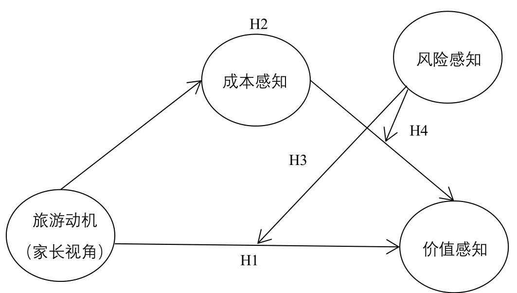
Under the guidance of national education policy, the demand for study tourism has increased significantly, and it is worth paying attention to how parents, as the actual purchasing decision-makers of study tourism products, reflect their needs and attitudes. Taking nature education study tourism as the specific research context, questionnaires were distributed to parents of primary and secondary school students to investigate the causal relationship between study tourism motivation and value perception from the perspective of parents' perception and incorporated cost perception and risk perception into the research to analyze the internal mechanism and boundary conditions between study tourism motivation and value perception. A statistical analysis of data from 539 parents revealed that parents' perception of study tourism motivation significantly and positively affects value perception. Cost perception has a mediator role between study tourism motivation and value perception, and parents' perception of study tourism motivation has a positive impact on value perception through the path of weakening cost perception. Moreover, risk perception negatively affects value perception, but a positive effect was observed when exploring risk perception's interaction with study tourism motivation and cost perception, respectively. Risk perception significantly enhances the positive effect of study tourism motivation on value perception, while suppressing the negative effect of cost perception on risk perception. Specifically, compared to low-risk perceptions, parents with high-risk perceptions perceive a more significant positive effect of study tourism motivation on value perception and a lower negative effect of cost perception on value perception; that is, risk perception plays a moderating role in the relationship between tourism motivation and value perception and in the path of the relationship between cost perception and value perception. However, when risk perception reaches a high level, its moderating effect on the relationship between cost perception and value perception is not significant; that is, parents pay more attention to risk and safety issues than to cost issues. The main theoretical contribution of this study is that it forms a theoretical complement to the investigation of the relationship between motivation and value, thus revealing the importance of the value of education for the average non-only-child family in China and cost as an important consideration for such families in their educational investment. It verifies the positive role of risk perception in the context of study tourism, which promotes further understanding of risk in the academic community and enriches the theoretical research on study tourism. In addition, this study provides a valuable empirical basis and practical enlightenment for the development of study tourism. It is necessary to design study tourism products based on demand, highlight product value, increase publicity and marketing efforts, control the safety of activities, set reasonable prices, and gain the attention of parent groups, all of which will be important considerations in further expanding the study tourism market.
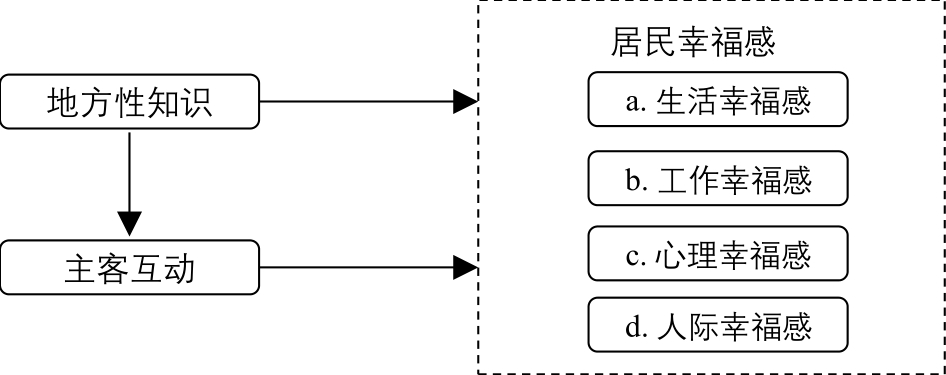
The happiness of residents is an important component of the sustainable development of heritage sites. Most previous studies have focused on the happiness of tourists rather than that of residents. The development of tourism at heritage sites and the increase in the number of tourists may either improve residents' happiness by promoting local development or reduce their happiness because of the environmental pressure and large number of tourists. The question arises as to the kind of residents who are more likely to gain happiness from the development of tourism at heritage sites. Based on the theories of local knowledge and flourishing happiness, this study investigated the residents of Jianglang Mountain, a world natural heritage site, and examined a model of residents' local knowledge, subject-guest interaction, and happiness (i.e., work, life, psychological, and interpersonal happiness). The findings answer the research question: whether residents with local knowledge are better able to achieve happiness and how they do so. The results of the study show that at heritage sites, local knowledge has a direct impact on residents' work, life, psychological, and interpersonal happiness. The interaction between the host and guest played a mediating role in these four influence paths. Theoretically, this study emphasizes that interpersonal happiness is a critical component of residents' happiness, which enriches the understanding of happiness theory in the tourism field. Second, to the best of the authors' knowledge, this study is one of the first to link local knowledge with residents' happiness, as the concept of local knowledge is primarily applied in studies of tourism resource development. The findings indicate that residents with greater local knowledge can obtain the aforementioned four types of happiness more easily. The third theoretical contribution of this study is the role of subject-guest interactions. To improve the happiness of residents at heritage sites through the local knowledge approach, the interaction between the host and the guest is important as it gives residents more opportunities to pursue better work, life, psychological, and interpersonal satisfaction. From this perspective, tourism development is a necessary part of the sustainable development of heritage sites. If the protection of heritage is overemphasized and the rational use of heritage is not highlighted, it could be a double-edged sword. Tourist visitation and the development of the tourism industry activate and empower heritage sites, thereby ensuring the happiness of residents and the sustainable development of heritage. In practice, this study suggests enhancing residents' happiness through education regarding local knowledge and improvement of subject-guest interactions. Practical recommendations are provided at the end of this article.
Leisure tourism has become a new hotspot of tourism consumption and promotes the upgrading of tourism industry structure. Moreover, the examination of the spatial accessibility of leisure tourism resources is conducive to improving the tourism flow system. This study takes 3,612 leisure tourism resource points in Guangzhou as the research object. These resource points are classified into natural leisure, recreational leisure, cultural leisure, and special leisure types according to their nature. The study uses the nearest neighbor index and kernel density to analyze the spatial characteristics of different types of leisure tourism resources in Guangzhou. Based on the 500 m×500 m raster division, it employs the raster analysis method to calculate the accessibility of different types of leisure tourism resources in Guangzhou and further investigates the formation mechanism of the accessibility spatial pattern. The conclusions are as follow: (1) The spatial distribution of leisure tourism resources in Guangzhou shows a general characteristic of "dense in the central city and sparse in the peripheral areas". (2) The spatial distribution characteristics of different types of leisure tourism resources varied significantly, with the highest degree of concentration in the cultural leisure type and the closest random distribution in the special leisure type. In terms of the clustering pattern, the natural and recreation leisure types are clustered in the main city and its surrounding areas, the cultural leisure type is a single cluster in the old town, and special leisure type is clustered in a polycentric manner. (3) The spatial pattern of the accessibility of leisure tourism resources in Guangzhou reveals clear traffic directionality, and the distribution pattern of high-accessibility areas is consistent with the direction of expressways, and forms a multi-well structure in space. High-accessibility areas are concentrated in the main urban and suburban areas, which are rich in leisure and tourism resources, and the spatial pattern of accessibility is characterized by a gradual decline along the traffic arteries with the central urban area as the core, reaching its lowest point in the northern part of Conghua District. (4) The high-accessibility centers for the natural leisure type are primarily distributed in the main urban area and the area with dense resources; the high-accessibility areas for the recreation leisure type are distributed in a row and its overall accessibility level is high; the high-accessibility areas for the cultural leisure type essentially cover the three old districts and the southern portion of Tianhe District, with a low accessibility level in Conghua District. The special leisure type shows an obvious circular structure in the accessibility-related spatial pattern. (5) Based on the comprehensive effect of the "resource-transportation-population-administration" system, the accessibility pattern of leisure tourism resources in Guangzhou was gradually formed through the combined influence of the spatial concentration characteristics of leisure tourism resources, regional accessibility, leisure tourism market demand, and infrastructure construction.
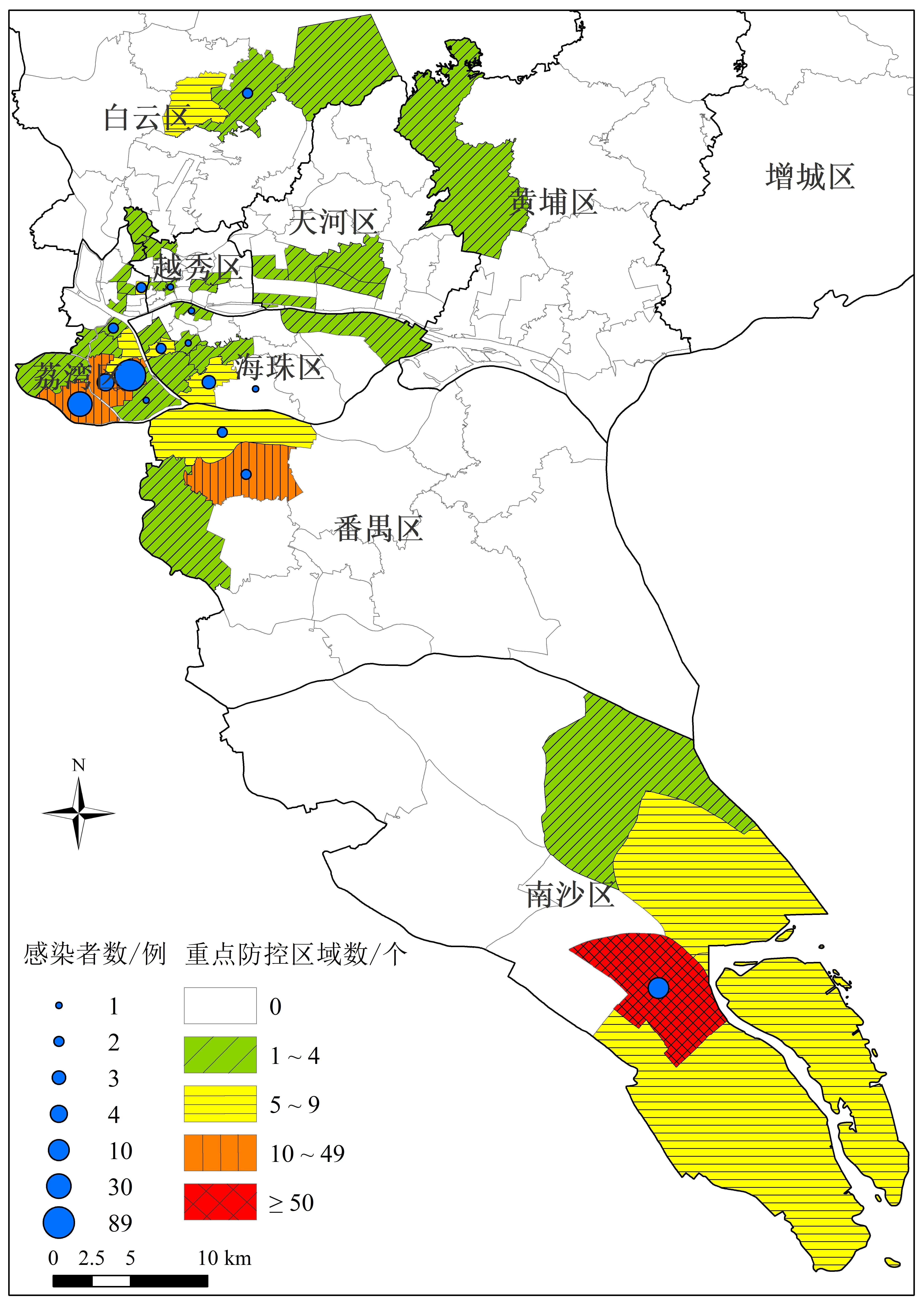
The "5·21" epidemic in Guangzhou was the first local outbreak in China caused by the COVID-19 mutation (Delta). This study analyzed the statistical characteristics, diffusion network, and prevention and control management of the epidemic domestically and globally, using infected persons during the "5·21" epidemic in Guangzhou as an example. The research methods include statistical analysis, text analysis and social network analysis. The research conclusions showed: (1) that most infected people during the epidemic were older adults. The virus incubation period was short and spread quickly. Furthermore, nucleic acid detection and screening can accurately control the risk of virus transmission within a known range. The virus's travel path in Guangzhou helped clarify the transmission chain timeously and cut off the transmission route. (2) The infected persons in Guanzhou were distributed in fragments and distributed throughout the region, town streets, key areas, and designated prevention and control management areas. The infected persons were clustered in a few towns and streets in Guangzhou. The epidemic spread in Guangzhou is mainly due to interpersonal contact and has airborne spread characteristics. (3) The virus spread happened in "cluster" and "chain" formations. This network presents "small world" characteristics as a whole. In Guangzhou, nodes with high index values at the network node level have established extensive contact relations with other nodes and are on the key path of the epidemic contact diffusion network. They are the key objects of hierarchical and classified epidemic prevention and control management. (4) The "5·21" epidemic situation in Guangzhou shows the hierarchical and classified prevention and control management measures should include 10 aspects: access management, community control, home isolation, demand guarantee, domestic waste treatment, environment disinfection, health monitoring and services, nucleic acid detection, publicity and guidance, control lifting.
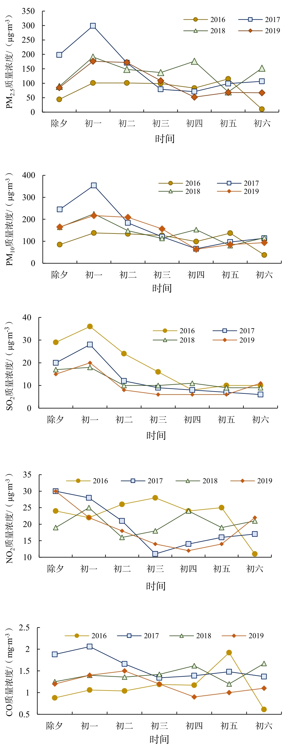
Based on air quality data from dense local micro-stations and sparse national stations, and meteorological data, this study examined the temporal and spatial patterns of air pollution during the Spring Festival in Xiangyang using high-frequency spatial analysis, correlation analysis, and pollutant concentration comparison. The implementation effect of a policy banning fireworks and firecrackers during the Spring Festival was evaluated. The results showed that during the Spring Festival in 2018, the weather in Xiangyang was relatively stable, and the air quality was generally poor. Owing to the influence of fireworks and firecrackers set off from New Year's Eve to the first day of the Lunar New Year in the peripheral areas of Xiangyang, the air pollution condition shifted from mild to severe. The concentrations of PM2.5 and PM10 increased gradually from 19:00 on New Year's Eve, rose linearly after 00:00 on the first day of the Lunar New Year, and then reached a peak during the Spring Festival at 08:00. During this period, the concentrations of SO2 and NO2 also increased significantly, whereas that of CO had no obvious regularity. During the Spring Festival, the spatial distribution patterns of PM2.5 and PM10 daily average concentrations showed a moderate or higher pollution trend of "high in the South and low in the North" on New Year's Eve and the second to fifth days of the Lunar New Year, with Hanjiang and Tangbai Rivers as the boundaries. On the first and sixth days of the Lunar New Year, air pollutants covered almost all of Xiangyang. The setting off of fireworks and firecrackers in the surrounding areas is the primary cause of the heavily polluted weather from New Year's Eve to the first day of the Lunar New Year, and until the fourth day. Traffic exhaust, road dust, and cooking fumes remain significant sources of air pollutants in Xiangyang during the Spring Festival. The characteristic geographical environment and variable meteorological elements are important factors that cause air pollution. Owing to the continuous adoption of air pollution prevention and control policies over the past four years, the overall air pollution situation has improved in Xiangyang. The scope of the firework bans was gradually expanded, thus effectively improving the overall air quality. Compared with research on urban air pollution using a small number of monitoring stations, the application of a high-density air quality monitoring network can describe in detail the spatio-temporal distribution characteristics of urban air pollution on a local scale. Accordingly, increasing the frequency of the spatial analysis of air pollution can allow for the deduction of the specific evolutionary process of air pollution in space. Particularly in special periods or polluted weather, a precise understanding of the spatio-temporal evolution of air pollution can provide an important basis and reference for the prevention and control of urban air pollution.
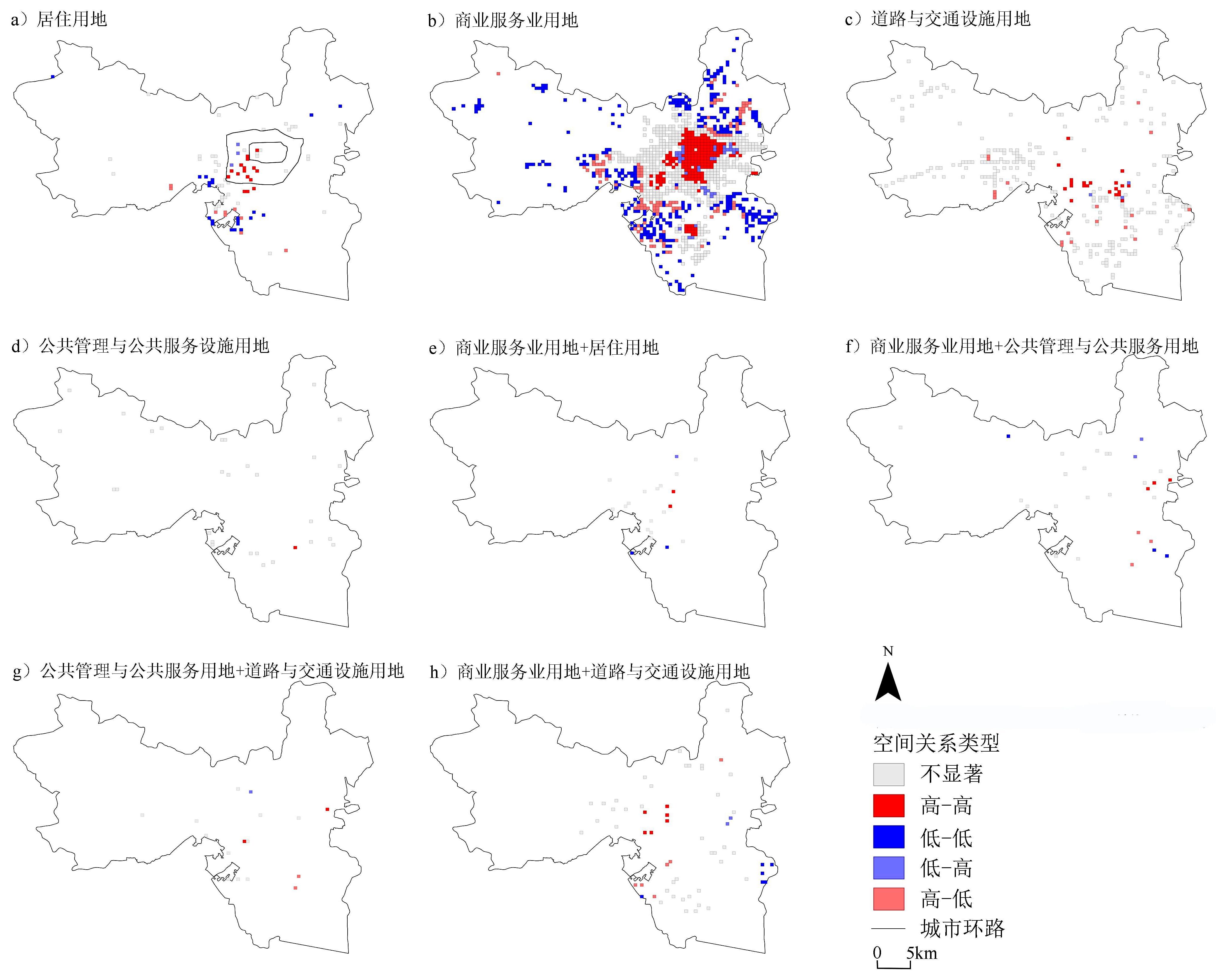
With accelerated urbanization, urban nighttime crimes—especially robbery, snatching, and theft—have received increasing attention from scholars as the highest incidence of local criminal crimes. Related studies have pointed out that the phenomenon of nighttime robbery, snatching, and theft crimes in most cities show the characteristics of spatial clustering, which is similar to the distribution characteristics of urban nighttime lights. Simultaneously, the correlation between urban lighting and nighttime robbery, snatching, and theft varies in different functional areas. Recently, the Suomi National Polar-orbiting Partnership Satellite(NPP-VIIRS) nighttime light remote sensing data have greatly improved the accuracy of nighttime light remote sensing, providing a more accurate basis for the study of urban nighttime social behavior. The quantitative identification method of urban functional areas based on POI and programming languages has been gradually improved, as well. In view of this, a bivariate spatial autocorrelation model was constructed based on the 110 police data from October to November 2017 in H city. The correlation between urban lights and robbery, snatching, and theft crimes at night was explored from the perspective of the main urban area as a whole and different functional areas. According to the model, (1) from the perspective of the main urban area, nighttime robbery, snatching, and theft crimes in H city form a fixed crime hotspot of "one main and one vice," and the correlation between lights and nighttime crimes varies spatially. The results further confirm that the correlation between urban nighttime light and nighttime crime varies according to the nature of urban functions. (2) Both single and mixed sites show clustering characteristics on global Moran's Ι, indicating that the correlation between urban nighttime light and nighttime robbery, snatching, and theft crimes is real. (3) The results show that urban night light and nighttime robbery, snatching, and theft crimes show obvious spatial correlations in commercial and business facilities, and such correlations show large spatial differences, with high-high clusters distributed in the central area of the city and low-low clusters in the peripheral area; urban night light and nighttime robbery, snatching, and theft crimes in residential facilities show north-south differences. Road, street, and transportation facilities are characterized by high crime rates inside public transportation and high mobility, which may lead to discrepancies between the location of the alarm and the actual crime location, ultimately making the results less credible. The correlation between urban night-light and robbery, snatching, and theft crimes at night shows that an increase in urban economic vitality brings about the social problems of robbery, snatching, and theft crimes in cities, which is contrary to the original intention of urban development. Therefore, to limit robbery, snatching, and theft crimes at night from the perspective of urban development, the correlation between nighttime crime and urban vitality, and the analysis of the influencing factors, need to be explored in greater depth.
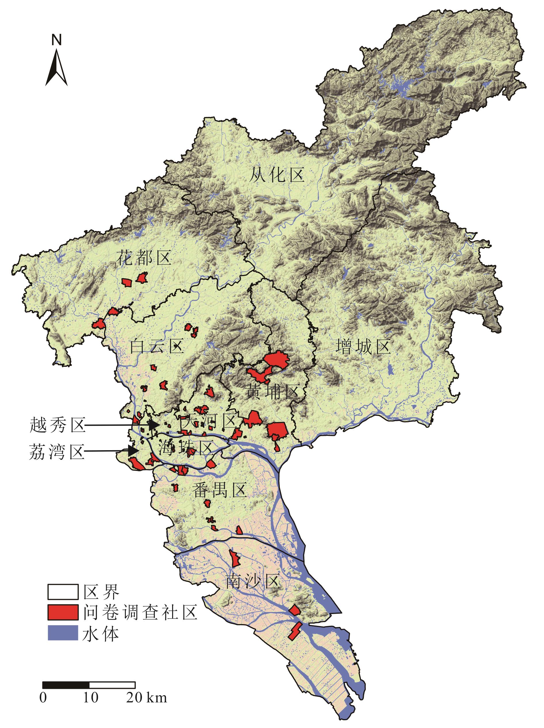
Research on the relationship between social isolation and crime has mainly focused on racial or ethnic social isolation; however, data on the individual activity and emotional and other aspects is relatively insufficient. Based on the questionnaire data, this study constructed an index system of social isolation combining social connection, neighborhood connection, activity connection, and emotional connection, controlled the impacts of basic attributes of the individual, and analyzed the correlation between social isolation and the four crime types, namely violence, burglary, pickpocketing in the community, and pickpocketing outside the community. In this study, 74 typical communities in Guangzhou, China were selected. A total of 1,568 questionnaires were distributed through a household survey among which 1,148 questionnaires were selected for the final analysis from the residents who had lived in the community for more than three years. Findings indicate that social isolation has a significant positive correlation with the residents' criminal victimization while there is a negative correlation between some indicators and specific crime types. (1) There is only one index with significant correlation between social isolation and violence (negative correlation), which means whether the residents can make suggestions to the neighborhood committees and other departments. (2) The indexes with a significant correlation between social isolation and burglary include the number of family members and friends in the community (negative correlation), community affection (positive correlation), and community management service satisfaction (positive correlation). (3) Indicators of a significant correlation between social isolation and pickpocketing in the community include the number of relatives and friends in the community (negative correlation), whether neighbors visit each other (positive correlation), whether neighbors borrow from each other (negative correlation), and the residents' satisfaction with the community management services (positive correlation). (4) The indicators of a significant correlation between social isolation and pickpocketing include unemployment (negative correlation), harmonious neighborhood relationships (positive correlation), opinions and suggestions (negative correlation), and the residents' feelings toward the community management services(positive correlation). In general, there are differences in the impact of social isolation with different measurement dimensions on the infringement of urban residents, and this difference varies with the type of infringement. The contribution of this study to the existing literature is reflected in the following two aspects: first, the research framework is optimized, and in the process of the research, community connection, neighborhood connection, building environment, and management service evaluation are added to represent individual emotions, and the influence of these factors on the residents' criminal infringement is discussed. Second, based on the index system of social isolation, this study analyzes the correlation between social isolation and the criminal infringement of residents from the perspective of social network relationship, which is also a supplement to the existing literature.
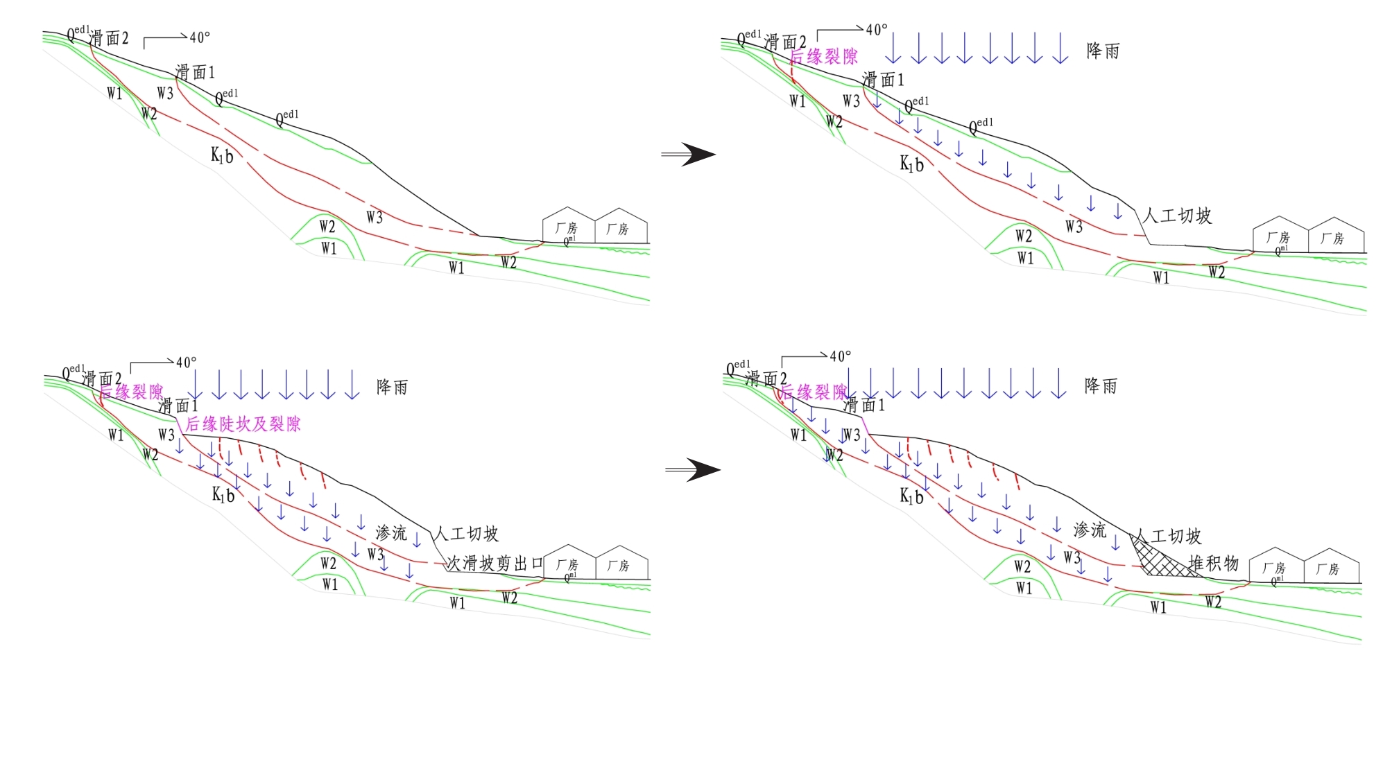
Landslide No.3 in Fei'e Mountain is located in the Shunde District of Foshan City, Guangdong Province, and its' lithology is mainly composed of pre-Cretaceous Baizushan Formation (K1b) argillaceous siltstone. In this study, engineering geological drilling, geophysical exploration, geological mapping, and indoor testing were used to determine that it is a medium-scale bedding rocky landslide with a typical double-layer deep sliding surface. The maximum length of the landslide body is approximately 220 m in the longitudinal (south-west) direction and approximately 230 m in the horizontal (north-west) direction; the maximum thickness is approximately 32m, and the attitude of sliding surface is 230°∠12°-17°. Landslide body tensile cracks, including nine large-scale tensile cracks, are very well-developed. The longest crack is approximately 120 m long and has a crack opening width of 0-13 cm, with a height difference between the two sides of the crack (rupture wall) of 0-0.2 m. The ground of the leading edge of the landslide was uplifted and cracked, with a maximum uplift height of approximately 1.7 m. The landslide shear outlet was clearly visible and exhibited well-developed scratches. The scratch direction was the same as the main slide direction of the underlying landslide. Landslide deformation severely cracked the building structure and obstructed the drainage channel. There was a loose residual soil layer on the surface of the slope of Landslide No.3, and many fractures and joints were present in the lower bedrock. During rainfall, rainwater penetrated the deep part of the slope along the rock layer surface, joints, and fractures, which greatly increased the bulk density of the rock and soil mass, and softened the argillaceous siltstones, which greatly decreased their shear strength. The excavation of the slope formed a steep surface, which reduced the load at the foot of the slope and thus reduced the anti-sliding force. During long-term seepage, the rock and soil mass near the landslide face was softened to form a weak zone mixed with joints and stratigraphic phases. During long periods of heavy rain, the weak zone became soaked, soft, and plastic, which reduced its shear strength. When downward force increased, the effective anti-sliding force of the weak zone was greatly reduced, resulting in a landslide. During this process, Landslide No.3 developed two slip surfaces. The maximum buried depths of slip surfaces 1 and 2 (corresponding to landslides 1 and 2) were 32 and 15.5 m, respectively, which means that landslide 2 overlaid landslide 1 and slip surface 1 creeping occurred before that of slip surface 2. The trailing edge of slip surface 1 developed a fissure, the characteristics of which are described above. As the fracture surface was not fresh, its' development time is unknown. As in the sliding process, landslide 2 first formed a continuous sliding surface, and its' sliding rate was slightly greater than that of landslide 1, landslide 2 was the first to cut out from the steep ridge of the landslide's front edge. As a result of the shearing action of landslide 2, landslide 1 developed multiple vertical cracks. Rainwater seeping down these cracks further lubricated slip surface 1, which resulted in drum mounds and cracks in the leading edge of the landslide. Slip surface 1 subsequently formed a continuous sliding surface, and Landslide No.3 entered the uniform deformation stage. Timely emergency measures prevented landslide deformation damage and halted landslide progression before entering the accelerated deformation stage. Considering its double-layer slip surface structure, a comprehensive combination of slope cutting, an anchor (cable), lattice beam, double-row prestressed anchor-pulling anti-slip pile, three-dimensional mesh grass greening, interception, drainage, and a hairy stone retaining wall was used to prevent and control the landslide. Long-term monitoring results showed that these methods had a high rectification effect and successfully controlled landslide deformation and displacement.