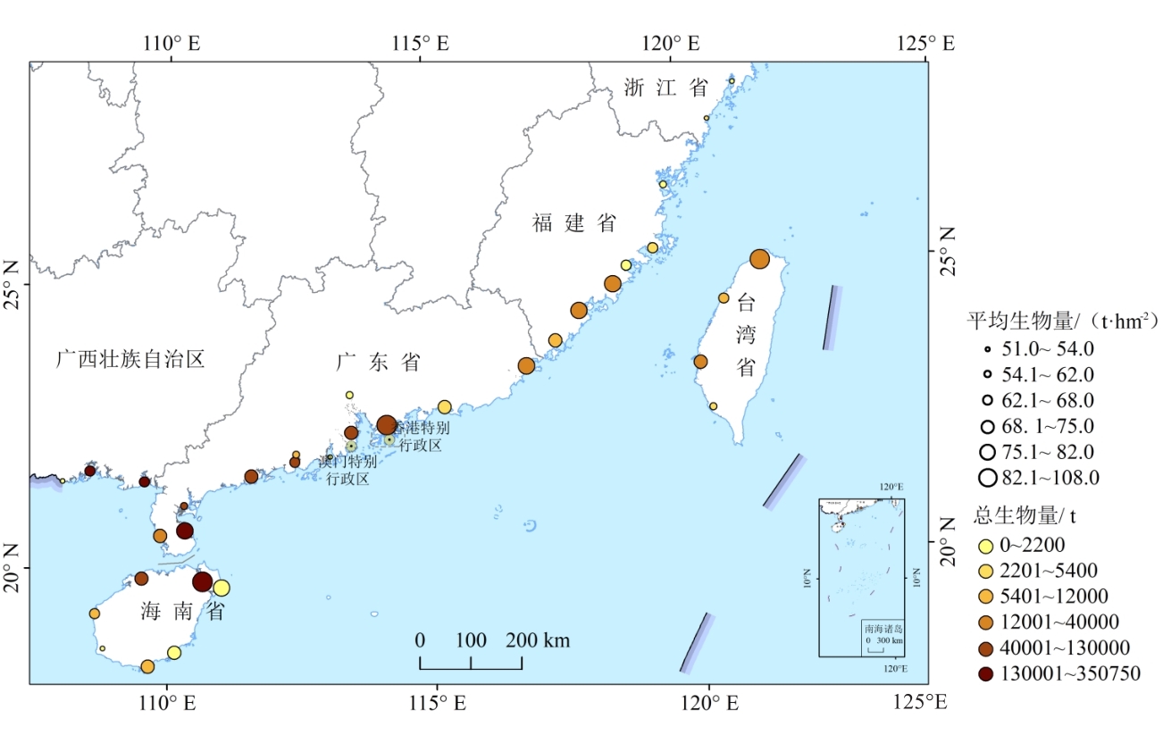
Mangroves, which have extremely high primary productivity, are efficient coastal blue carbon ecosystems. Aboveground biomass (AGB) is an important component of vegetation carbon pools. Thus, accurate estimation of mangrove AGB is critical for studying carbon cycle and climate change. While the practical significance and application of information obtained on mangrove AGB in China is apparent, studies of this nature in China at a national scale have rarely been reported. Remote sensing technology is convenient, efficient, has a wide observational range, and can be used for large-scale ecosystem monitoring. Canopy height is a structural parameter that is positively correlated with the AGB of vegetation. The Global Ecosystem Dynamics Investigation (GEDI) spaceborne Light Detection and Ranging (LiDAR) satellite, launched in recent years, is able to obtain vegetation canopy height. This study employed forest canopy height derived from GEDI satellite-based LiDAR and an allometric equation based on the allometric theory to estimate mangrove AGB in China in 2019, and the quantitative and spatial distribution of mangrove biomass and their main influencing factors were analyzed. The results showed that the total and mean AGB of mangroves in China in 2019 were about 1,974,827 t and 73.0 t/hm2, respectively. Guangdong-Hong Kong-Macao area showed the largest total mangrove AGB, reaching 843,836 t. The mean values of AGB in each province (region) with mangrove ecosystems nationwide ranged from 53.3 to 92.1 t/hm2, of which the largest was found in Hainan Province, reaching 92.1 t/hm2. In Hainan, Taiwan, and Fujian provinces, mean mangrove AGB was higher than the national mean. Considering nature reserves, the mean AGBs of mangroves in Neilingdingdao-Futian and Mai Po mangrove nature reserves in Shenzhen Bay in the Guangdong-Hong Kong-Macao area and Dongzhaigang mangrove nature reserve in Hainan province were relatively high, with values greater than 110 t/hm2. The accumulation and distribution of mangrove AGB in China are affected by latitude and anthropogenic factors. This study provides a comprehensive analysis of mangrove AGB in China based on remote sensing and an allometric equation and can provide a database and technical reference for estimating carbon storage in mangrove ecosystems. It will also contribute to the implementation of ecological restoration and protection measures for coastal mangroves, as well as carbon emission control in China.
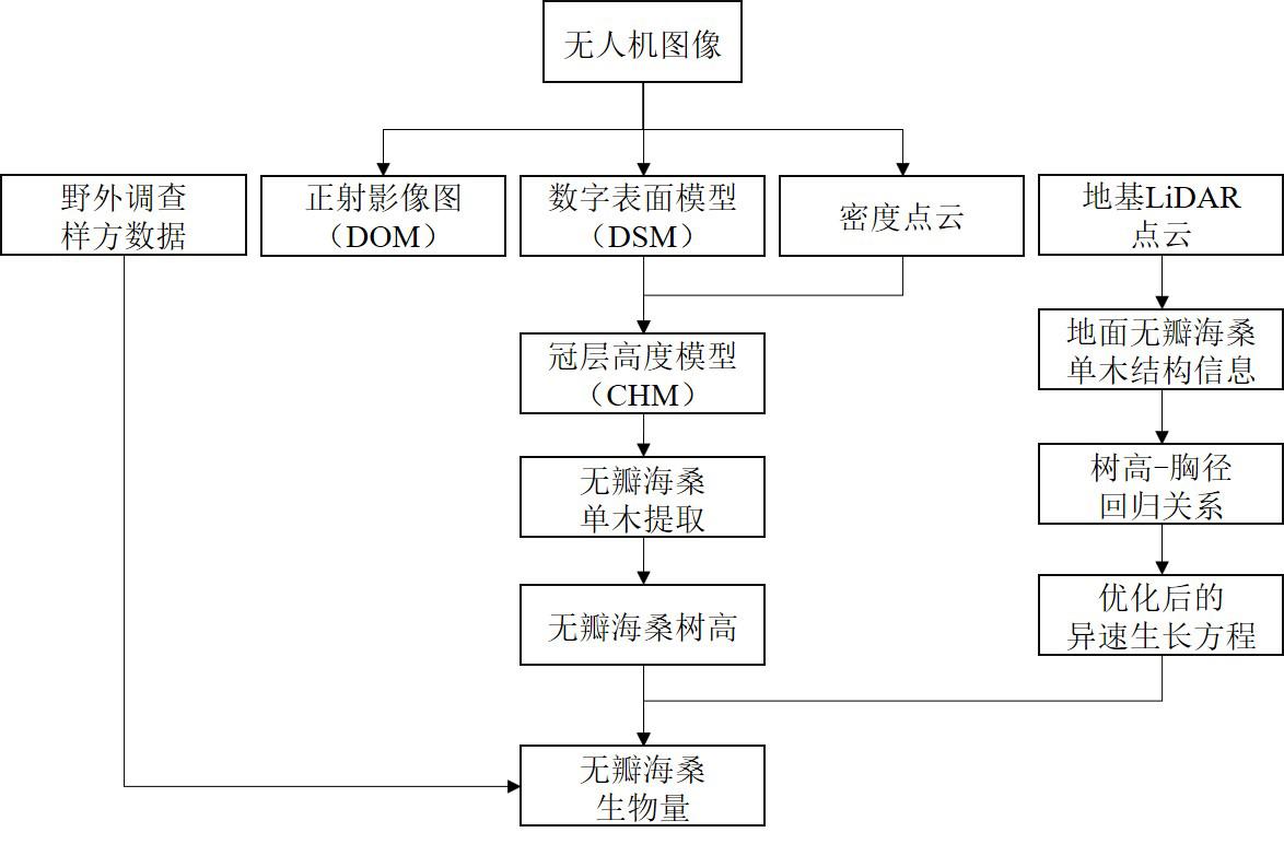
Accurate mangrove biomass measurement is necessary for the management and protection of mangrove ecosystems. Sonneratia apetala was the first high-quality mangrove species to be introduced for mangrove restoration in China. Compared with other mangrove species, Sonneratia apetala has higher productivity and can store large amounts of carbon in its living biomass. However, accurate depiction of the single-wood canopy of Sonneratia apetala is challenging because of its high clumping density and intricate canopy structure. While traditional satellite remote sensing focuses on regional or larger-scale monitoring needs, the newly emerged Unmanned Aerial Vehicle (UAV) remote sensing has significant advantages for monitoring mangroves at finer scales. However, few studies have used UAV data for mangrove biomass analyses. In this study, we successfully used consumer-grade UAV data to estimate the height and aboveground biomass (AGB) of Sonneratia apetala on Qi'ao Island, Zhuhai, Guangdong Province. We used a variable window filter algorithm to detect the treetops. Individual tree canopy segmentation was performed using the seed region-growing algorithm. Additionally, we constructed a regression equation for height (H) and diameter at breast height (DBH) of Sonneratia apetala in the study area and optimized the traditional allometric equation. Finally, mangrove AGB was estimated at the tree level using the optimized allometric equation, and the results indicated that the AGB of Sonneratia apetala could be accurately extracted using UAV images. The accuracy of the tree delineation was 67%, the correlation between H and DBH was DBH = 2.2726H-6.4415, and the correlation coefficient R2 was 0.8713. The aboveground mass of a single wood of Sonneratia apetala in the study area ranged from 29.60 to 388.44 kg, with a mean value of 145.72 kg and a total aboveground mass of 368.97 t. Partial spatial clustering was observed in the distribution of the aboveground mass of Sonneratia apetala in the study area, with a Moran's I index value of 0.594. The aboveground mass of Sonneratia apetala at the edge of the area and in the window part of the area was found to be smaller, mainly for two possible reasons. First, the natural death of Sonneratia apetala in part of the study area created a window, but its surrounding seedlings were still in the biomass accumulation stage. Second, the aboveground mass of Sonneratia apetala at the edges of the study area is often lost due to its vulnerable nature and anthropogenic factors. The average number of Sonneratia apetala in each quadrat was 6.3 and the AGB in the study area ranged from 2.99 to 247.24 t/hm2, with a mean value of 92.14 t/hm2. The estimated AGB based on UAV data was consistently lower than that generated from field data. The methods described in this study offer the possibility of easily repeatable, low-cost UAV surveys, providing a faster and more economical approach for monitoring mangrove forests than traditional ground surveys. These results may assist in decision-making regarding ecological monitoring, resource use, mangrove introduction, and scientific advancement of mangroves in China.
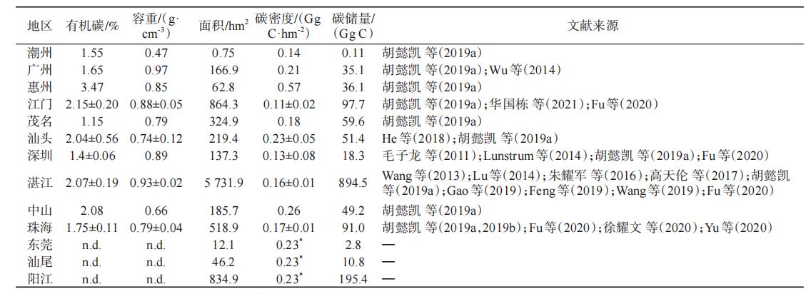
Mangroves occur in coastal intertidal zones and play an important role in terrestrial and marine carbon cycles. Accurate estimations of mangrove carbon stocks and sequestration potential can help quantify the contribution of mangroves to addressing climate change and achieving carbon neutrality goals. The carbon stocks and burial rates of different mangrove communities and regions in Guangdong Province were studied through literature collection and data integration. The soil carbon densities of the Rhizophora stylosa and Bruguiera gymnorhiza communities were 0.27 and 0.23 Gg C/hm2, respectively, while the soil carbon density of the Kandelia obovata community was the lowest at only 0.13 Gg C/hm2. The area of mangroves in Guangdong Province is 9,106.2 hm2, the total carbon stock is 1,542.02 Gg C, and the soil carbon density is 0.23 Gg C/hm2. The total carbon reserves of mangroves in thirteen regions are in the following order: Zhanjiang (894.5 Gg C) > Yangjiang (195.4 Gg C) > Jiangmen (97.7 Gg C) > Zhuhai (91.0 Gg C) > Maoming (59.6 Gg C) > Shantou (51.4 Gg C) > Zhongshan (49.2 Gg C) > Huizhou (36.1 Gg C) > Guangzhou (35.1 Gg C) > Shenzhen (18.3 Gg C) > Shanwei (10.8 Gg C) > Dongguan (2.83 Gg C) > Chaozhou (0.11 Gg C). Using the 210Pb method, the sediment accretion rate was found to be 13.47 mm/a. Qi'ao Island had the highest sediment compaction rate of 31.5 mm/a, followed by Zhenhai Bay, with 16.5 mm/a, Shenzhen Futian, with 15.9 mm/a, and Leizhou Bay, with the lowest sediment compaction rate of 7.3 mm/a. The carbon sequestration capacity of Guangdong province is approximately 19.72 Gg C/a, with the Leizhou Peninsula having the highest (6.05 Gg C/a) and Futian, Shenzhen having the lowest (0.66 Gg C/a) capacities. The carbon storage of mangroves in Guangdong Province was 1,542.02 Gg C, which was higher than that in other regions. The carbon sequestration capacity of the mangroves was relatively strong. Therefore, the protection and restoration of local mangroves may substantially contribute to the mitigation of climate change while providing additional benefits. This assessment, on a provincial scale, provides insights into blue carbon sequestration capacity, thus contributing to the synchronous progression of blue carbon management.
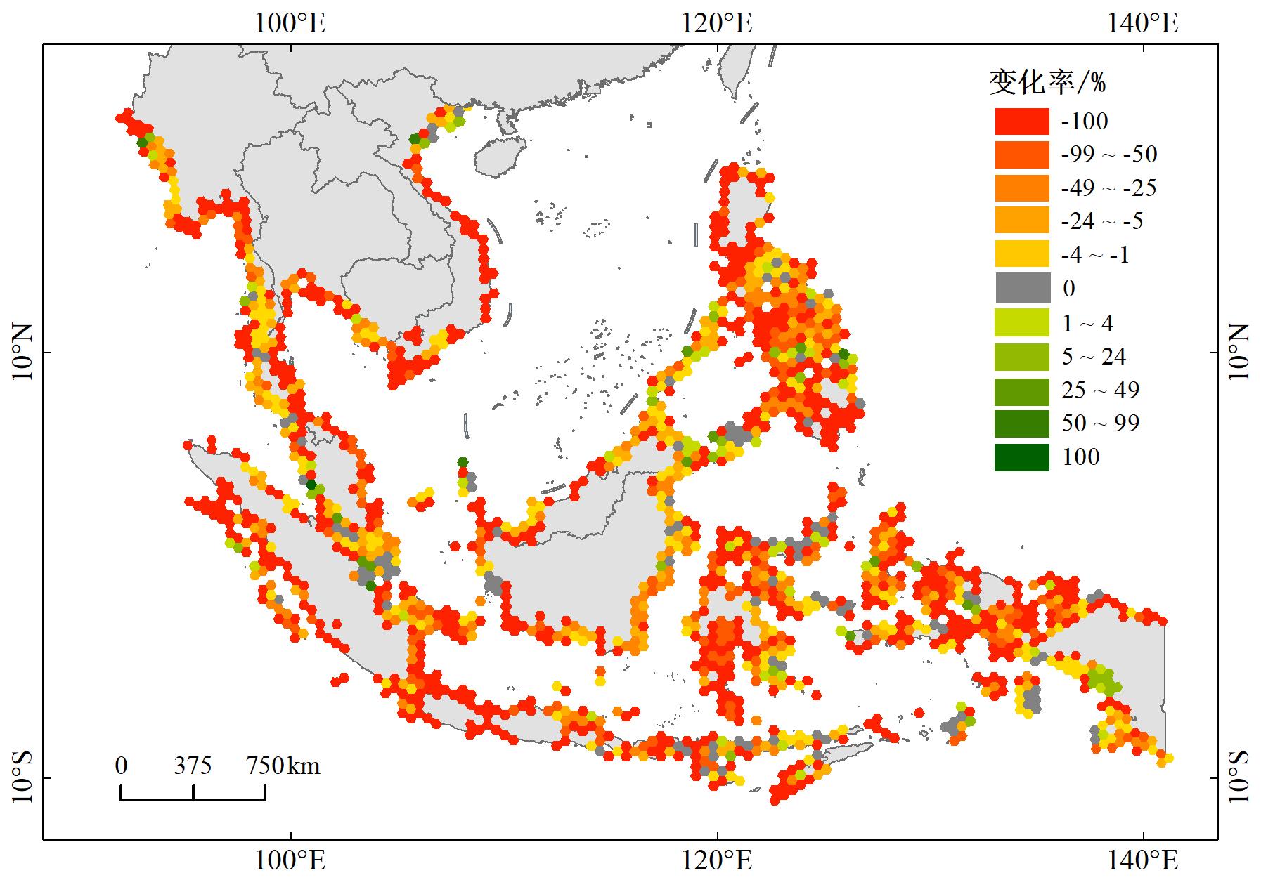
Mangroves are woody wetland communities that grow in the intertidal zones of tropical and subtropical coasts and are among the most productive ecosystems in the world. Mangroves provide important support for coastal ecological and environmental protection, social development, and economic progress. Those found in Southeast Asia are a key portion of global mangroves. The study of spatiotemporal changes of mangrove forests and their driving factors in Southeast Asia can provide a theoretical basis and supportive evidence for the scientific protection and effective management of mangrove ecosystems. Based on the cloud computing platform of the Google Earth Engine, Landsat satellite data, and mangrove distribution data sets, combined with the Theil-Sen median trend analysis and Mann-Kendall test methods, this study analyzed the spatial variation trend of mangroves in Southeast Asia from 1990 to 2020. A factor detector and an interaction detector in the geographic detector method were used to quantitatively analyze the driving factors. First, the results showed that, from 1990 to 2020, the overall mangrove area in Southeast Asia showed a downward trend, with an area reduction of 1,467,883.1 hm2 and an annual average loss rate of 1.1%. According to the statistics of the mangrove area change rate based on cellular network data, the total loss of mangrove area was as high as 40.11%. Of the total mangrove area, the regions with a change rate between -99% and -50% accounted for 28.57%, regions with a change rate between -49% and -5% accounted for 8.79%, and regions with a change rate between -4% and -1% accounted for only 13.95%. Regions with a change rate between 1% and 99% accounted for 8.18%. Only 0.4% of the mangrove area remained unchanged. The regions with increased mangrove area were primarily distributed in the Philippines, western and eastern Indonesia, and northern Vietnam. Second, the improvement and degradation of mangroves in Southeast Asia showed a concomitant distribution from 1990 to 2020. The degradation area of mangroves (79.25%) was much larger than the improvement area (20.32%) in Southeast Asia. Specifically, the significantly degraded areas accounted for 31.58%, the slightly degraded areas accounted for 47.67%, the significantly improved areas accounted for 4.75%, the slightly improved areas accounted for 15.57%, and only 0.42% of the area remained stable. Finally, the increase in aquaculture pond area was the main driving factor for mangrove area decline, with q values above 30%. Additionally, the shortest distance of mangroves from roads and population changes also had significant effects on the decline of mangrove area. The average annual temperature, precipitation, and topography had a relatively low degree of influence on mangrove changes. The results of the interaction detector indicated that all factors showed interaction enhancement, and the interaction between the culture tank and other factors was significantly stronger than that between other factors. The single factors with relatively weak driving force, such as average annual rainfall, temperature, and topography, had a significantly stronger influence on the interaction with other factors and showed a nonlinear enhancement effect.
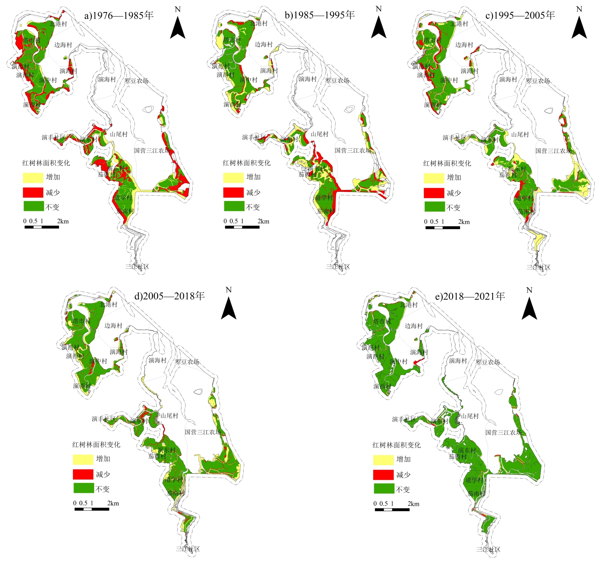
Human activities such as deforestation, farming, and uncontrolled construction have had a negative impact on mangrove areas in the Reserve. This paper explores how the mangrove area and space have changed since the establishment of the Dongzhaigang Mangrove Nature Reserve, as well as the relationship between this change and the community residents around the Reserve. Six remote sensing images, from 1976 to 2021, were used to obtain wetland data of different ages in the Dongzhaigang Mangrove Forest Nature Reserve in Haikou City. Using the transfer matrix, a questionnaire survey, and principal component analysis, we analyzed the changes in mangrove forests in protected areas and their relationship with surrounding communities over the past 45 years. The results show that: (1) From 1976 to 2021, the area of mangroves in the reserve has increased from 1,395.84 hm2 in 1976 to 1,589.28 hm2 in 2021, showing a trend of "suddenly slowing and rising" during this period, and the proportion of mangrove area has increased from 28.6% in 1976 to 32.6% in 2021, becoming the main wetland type. The largest decline (250 hm2) in the mangrove area was from 1976 to 1985. The largest growth occurred from 2005 to 2018, when the mangrove area increased by 190.08 hm2. (2) From 1976 to 2021, 91.77 hm2 of mangrove wetlands in the study area were converted into other wetlands, 10.71 hm2 were converted into non-wetlands, and 267.71 hm2 of other wetlands and 28.21 hm2 of non-wetlands were converted into mangrove wetlands. In the same period, the transfer targets of mangrove forests in the reserve were muddy beaches (34.32 hm2), rivers (25.81 hm2), marine aquaculture farms (21.06 hm2), other land (10.58 hm2) and flooded wetlands/interiors. Land flats (8.26 hm2); silt beaches (177.41 hm2), rivers (38.18 hm2), other land (28.21 hm2), deltas/sands/sand islands (22.15 hm2), flooding Wetlands/inland tidal flats (21.79 hm2), and paddy fields (6.34 hm2) are the most common areas transferred into mangroves. (3) Fishing income from surrounding community-dwelling individuals was significantly associated with farming, disfiguring forest-digging pond areas, conservation awareness, and mangrove area variation. The factor quality of fishing practices (cos2), values of fishing practices and income, months of fishing, fishing volume, and conservation attitude in the surrounding community residents accounted for more than 0.6 in the principal component analysis of area change of mangrove forests, where the factor quality of fishing practices and fishing income were more than 0.8. The decline in residential fishing frequency corresponds with the shift in household income sources, the occupational move from fishing to wage and service industries, the obvious increase in conservation awareness and the conservation attitude of residents, and the transformation of the mangrove area away from serious destruction to less fragmentation. The contributions of freshwater farms, resident population, number of secondary schools, and village to mangrove distance factors were all greater than 10 and negatively correlated with mangrove area change. Therefore, it is necessary to explore the relationship between mangroves and community residents to obtain a scientific reference for the utilization, protection, restoration, and management of mangroves in the Dongzhaigang Mangrove Nature Reserve.
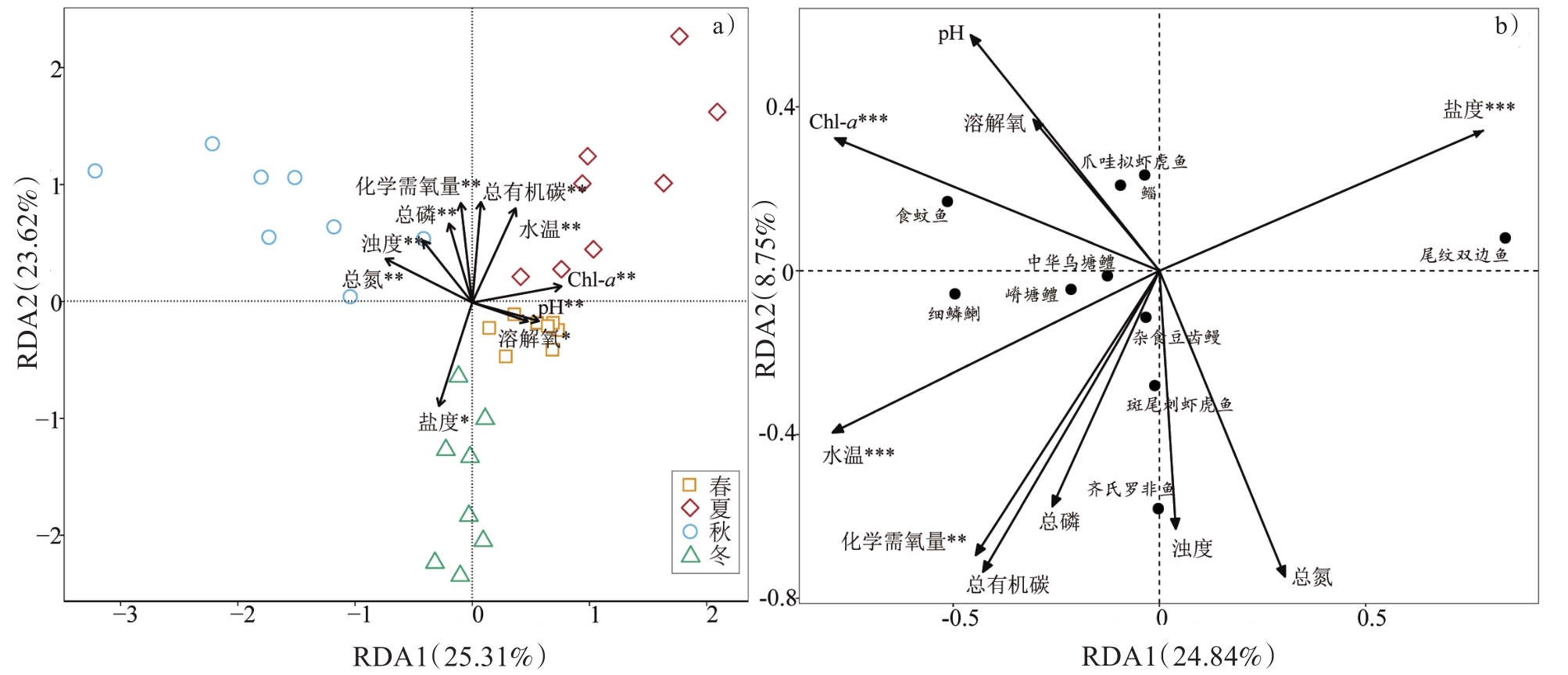
Mangroves are one of the most important wetland ecosystems. The development of fisheries in tropical and subtropical bays or estuaries is closely associated with mangroves since the high heterogeneity of the mangrove ecosystem provides a suitable habitat for marine organisms. However, multiple factors have led to a significant reduction in mangroves, such as water pollution, disease, insect pests, invasive alien species, and climate change. It is crucial to understand the relationships among organisms, as well as the interactions between organisms and their environment, by studying the ecological niche width and overlap of species. Therefore, two new perspectives of ecological niche width and ecological niche overlap were used to understand the interspecific ecological relationships, competition mechanisms, and resource utilization status of fish communities in mangrove forests. Based on the data collected during seasonal sampling in July 2019 (summer), October 2019 (autumn), January 2020 (winter), and May 2020 (spring) in the Nanliujiang Estuary, the index of relative importance (IRI), Shannon index, and Pianka index were employed to analyze the temporal and spatial niche of the main fish species in the mangrove creeks and to study niche differentiation among the main fish species by redundancy analysis. A total of 17,680 individual fish were collected in this study, belonging to 12 orders, 23 families, 37 genera, and 45 species. Ten main fish species with IRI>100 were identified. Among the main fish species, the temporal niche breadth ranged from 0.46 to 1.78, with the highest of which belonging to Butis butis (1.78) and the lowest belonging to Pseudogobius javanicus (0.46). The spatial niche breadth ranged from 0.81 to 2.05, with the highest of which belonging to Synechogobius ommaturus (2.05) and the lowest belonging to P. javanicus (0.81). The spatiotemporal niche breadth of six species was greater than 2 (wide-niche species) that included Mugil cephalus, Coptodon zillii, Bostrychus sinensis, S. ommaturus, B. butis, and Pisodonophis boro. With regard to overlap, the temporal niche overlap between M. cephalus and P. javanicus was the highest (0.928), whereas that between Ambassis urotaenia and Terapon jarbua (0.001) was the lowest. The spatial niche overlap between A. urotaenia and Gambusia affinis was the highest (0.979), whereas that between M. cephalus and P. javanicus (0.178) was the lowest. Finally, the spatiotemporal niche overlap between C. zillii and P. javanicus was the highest (0.822), whereas that between A. urotaenia and Terapon jarbua (0.001) was the lowest. The two-dimensional temporal and spatial niche pairs in the mangrove creeks of the Nanliujiang River Estuary significantly overlapped (Qik > 0.6), accounting for 6.7% of the total species pairs, indicating that the temporal and spatial distributions of species were quite different and the temporal and spatial niche overlap was affected by seasonal changes. Redundancy analysis revealed that the main factors affecting spatiotemporal niche differentiation of the main fish species in the mangrove creeks of the Nanliujiang Estuary were water temperature, salinity, and Chlorophyll a. And the main fish biomass in winter was positively correlated with salinity; the main fish biomass in spring was positively correlated with dissolved oxygen, pH and Chlorophyll a; the main fish biomass in summer was positively correlated with total organic carbon, water temperature and Chlorophyll a; the main fish biomass in autumn was positively correlated with total nitrogen, turbidity and total phosphorus.
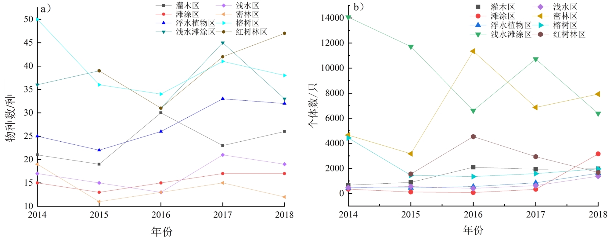
As an important land and water transition zone on Earth, wetlands are good places for birds to breed and roost. Bird monitoring has become an important index for assessing the biodiversity and ecological environment of a region. Nansha Wetland Park in Guangzhou is rich in biological resources and provides an important resting and wintering ground for global migratory birds as it is located on their migration route from East Asia to Australasia. To understand the migration patterns and annual dynamic changes of birds in the Nansha Wetland Park, line- and point-transect surveys were conducted to collect bird species and abundance data from January 2014 to December 2018. First, our results showed that 139 birds were recorded during the study period, of which migrant species were dominant. Combined with the available literature, a total of 186 bird species were recorded, belonging to 17 orders and 49 families. Of these bird species, 165 are under various levels of protection. Second, while the interannual changes in bird abundance were substantial, those of bird species richness were not, indicating that bird species tended to reach maximum abundance in bird communities. When compared to bird abundance in 2015, the number of individuals was relatively stable in other years of investigation, and the number of investigated species was the highest in 2017. Finally, monthly changes in bird species were in accordance with the annual rhythms of migration. Specifically, bird species richness increased rapidly during the wintering period, but remained constant during the breeding period. In addition, the migration time of waterbirds tended to increase over time. This may be related to a warming climate that prompts birds to migrate earlier. Differences in habitat patches are important influencers of bird feeding habits, and thus bird distribution and habitat. Among the habitat patches investigated, birds were primarily distributed in shallow tidal flats with rich food sources and in tall and lush mangrove communities, such as those containing the species Sonneratia apetala. Notably, the number of Platalea minor, a key indicator bird species, has increased steadily, with an increase of 346.15% from 26 in 2014 to 116 in 2018. The annual and monthly dynamic changes of birds in different areas showed subtle changes in individual numbers but generally showed a stable trend, which may be related to the environmental capacity of the habitat. The number of species and individuals that can be sustained by the environment tended to be saturated; that is, the maximum number of species that can be accommodated by the Nansha Wetland Park. Taken together, these findings suggest that bird species diversity could be promoted by expanding the area of tidal flats, increasing the planting area of mangroves, reasonably reclaiming wetlands, and maintaining the proportion of shallow water tidal flats and mangroves.
The Shanwei Special Cooperation Zone (SSCZ) in Shenzhen is the main distribution area of the Lianhuashan Fault Zone. Two large ductile shear zones pass through the SSCZ. The ductile shear zone of the SSCZ is henceforth referred to as "the zone". Severe plastic progressive deformation, stretching, and compression occurred in the late Jurassic-Neogene period in the zone, because of which the structure and properties of the rock mass underwent significant changes. There are three levels of structural planes in the zone: brittle faults, schistosity planes, and joints in the rock mass. The ductile shearing action changes the rock mass structure, leading to poor integrity. According to existing data, the compressive strength of the rock in the zone is equivalent to 0.31-0.86 of the original rock, indicating that the strength of the rock is obviously attenuated by ductile shear action. Using ground investigation and remote sensing, we found 1,614 topsoil slips in the zone. The density of topsoil slips in the hillside area (16.2 topsoil slips per km2) was much higher than that outside the zone (1.3 topsoil slips per km2), indicating that the slopes in the zone are more prone to shallow damage. To study the geological risk zonation of geological hazards in the SSCZ, it is necessary to determine the characteristics and distribution rules of topsoil slips in the zone, analyze its causal mechanism, and predict its development trend.ⅰ) Ground surveys and remote sensing showed that monocase topsoil slip is small in the zone and sliding mainly occurs along the bedrock surface. Sliding masses are mainly solid and completely weathered rock. ⅱ) The frequency of geological disasters under the action of certain factors in the study area is divided by the frequency of geological disasters in the area. The natural logarithm of the divisor is taken as the information value to evaluate the relationship between geological disasters and various factors. The results show that the density of topsoil slips is positively correlated with the degree of ductile deformation (strong→medium→weak), distance from brittle fracture (near→far), and topographic slope (high→low). Moreover, the distribution density is strongly related to the geomorphic unit, slope direction, original rock type, and slope type. ⅲ) The above analyses are combined with regional, geological, exploration, meteorological, and other data. Results from this combination show that topsoil slips in the zone are produced under weak background conditions formed by the influence of multi-stage tectonic action dominated by ductile shear forces, the slow rise of the hillside area, and the induction of typhoons and rainstorms. Their development and changes are characterized by migration, self-healing, and expansion. ⅳ) Most of the current topsoil slips occurred during Super Typhoon Mujigae in 2015, after which the region experienced several rainfall events with intensities higher than those of Typhoon Mujigae, yet the number of topsoil slips did not increase significantly. This shows that after a general shallow sliding event, the sensitivity of the slope to shallow damage decreased, and generation took a long time before entering the next outbreak period.
Cavernous weathering is widely distributed in different climate zones worldwide. The dominant controlling factors and their formation processes have long been discussed in the geomorphological community; however, many controversies remain. In the danxia landscape, various forms of cavernous weathering develop on steep slopes. They are important elements of the landscape and provide shelter for the preservation of many precious historical cultures, yet there have been few studies investigating their origin. Danxiashan is representative of the Natural World Heritage site 'China Danxia', with widespread cavernous weathering features of various sizes and shapes, providing a good opportunity for investigating the origin of cavernous weathering in subtropical humid climates. Typical caverns on sandstone and conglomerate slopes at five sites in Danxiashan were selected and studied by field investigation, morphological measurement, meteorological monitoring, sample microscopic observation, and salt experiments. The results show the following. First, the diameters of the cavern openings vary from centimeters to meters, and the shape of the cavern openings is elliptical to elliptical. The tafoni on conglomerate slopes are generally large and tend to grow upward and inward, while the caverns on sandstone slopes are generally small and arranged in a honeycomb-like structure. Second, lithology is fundamental for the development of caverns. At the macroscopic scale, it determines their location and arrangement because the caverns generally align within the lamination of beddings or cross-beddings. Indeed, the morphological characteristics of caverns developed differently under varying lithologies. At the microscopic scale, the red beds consist of abundant soluble mineral components, such as feldspars and carbonate cements, which are chemically dissolved in the seepage of acid rainwater, the salt crystallization of which leads to the destruction of the rock texture. Collectively, they would have initiated the formation of caverns. Third, the favorable microclimate within the caverns is a key factor that is water and salt accumulation, and consequently, salt weathering and enlargement of the caverns over time. Notably, the microclimate within the Jinshiyan Cave has provided favorable conditions for algae colonization, which controlled the formation of the cell-and-wall structure of the regular honeycombs at the Longlingpian Rock. Finally, the dominant controlling factors were dissimilar between caverns and interplayed in different development stages of cavernous weathering, the entire progression of which was potentially regulated by a self-organized mechanism. However, the influencing factors and critical values of the positive and negative feedback mechanisms require further study.
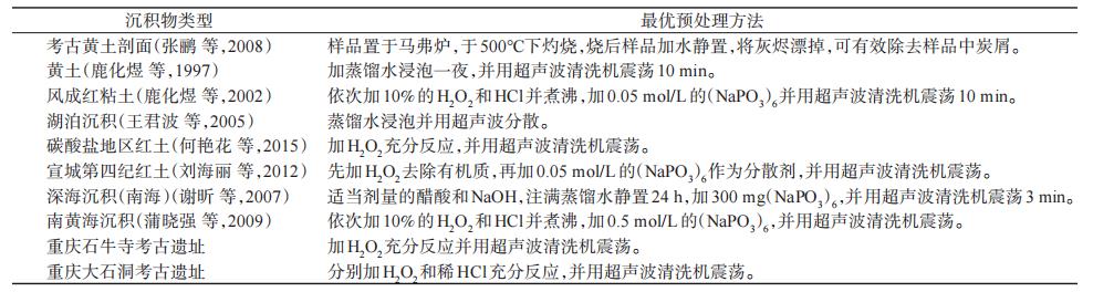
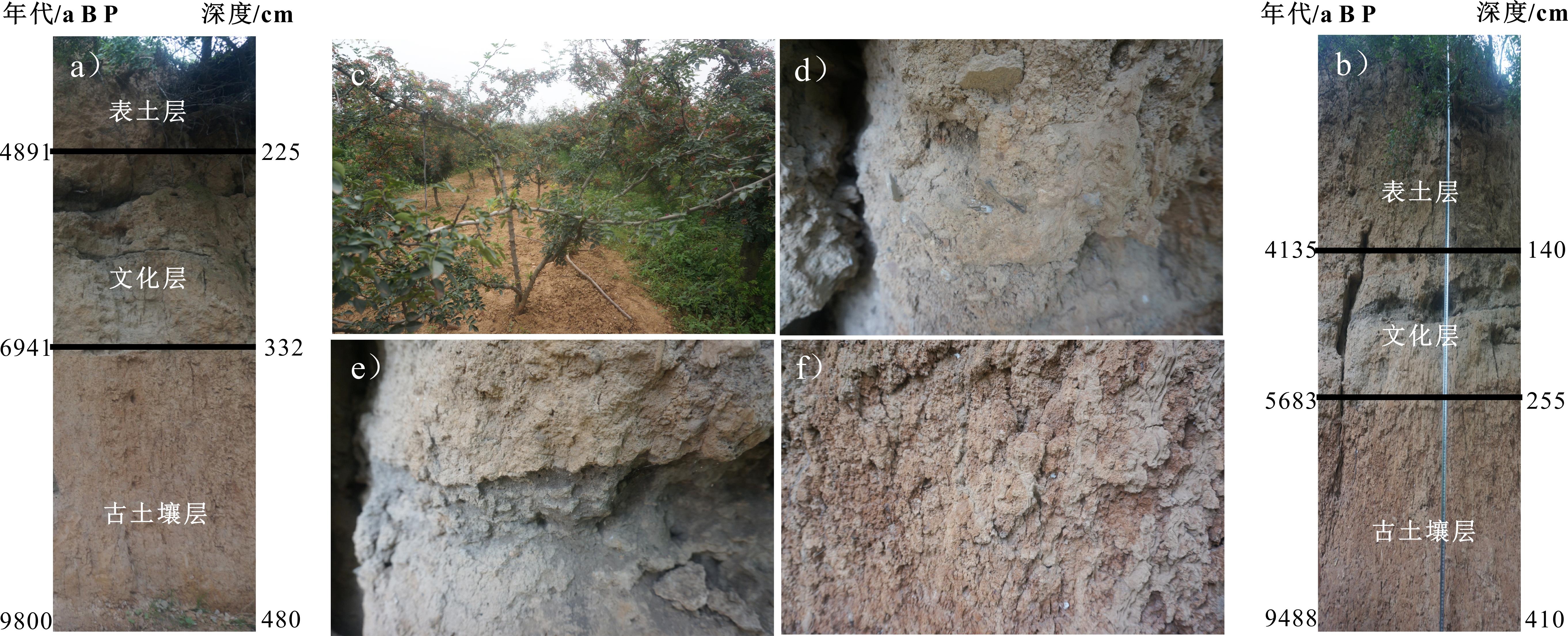
In this study, 24 samples from sections of Shiniu Temple and Dashidong archaeological sites in Chongqing were selected to compare the effects of different pretreatment methods on grain size analysis. Each sample was pretreated using one of five methods: (A) pretreating with distilled water, (B) pretreating with (NaPO3)6, (C) pretreating with H2O2, (D) pretreating with HCl, and (E) comprehensively pretreating with H2O2,HCl, and (NaPO3)6. Pretreated samples were ultrasonically dispersed for 10 minutes before examination using a Malvern Mastersizer 2000. First, with the addition of distilled water or the 0.05 mol/L (NaPO3)6 dispersant, a dispersion effect was not obvious. Indeed, the main grain size parameters were similar to those seen without any pretreatment (method A), indicating that physical pretreatment methods can neither remove possible impurities, such as carbonates and organic matter, nor disperse the potential cementitious particles in the sample. Second, the addition of H2O2 effectively removed organic debris at the archaeological site, enabling the experimental results to accurately reflect the grain size characteristics of inorganic particles in the sediment. The average median grain size of the sediments at the Shiniu Temple archaeological site was the smallest, and the clay content was the highest after being pretreated in this way. The sand content was reduced by approximately 50% compared with that of the sample without pretreatment. The performance is very stable throughout the Shiniu Temple profile; however, for some samples rich in carbonate cement at the Dashidong archaeological site, the effect of this pretreatment method is limited. Third, after pretreatment with 10% dilute HCl, the median grain size of the sample from Shiniu Temple site increased, the sand content remained similar, and the clay content was significantly reduced. The clay content and sand content of Dashidong site decreased simultaneously, revealing that HCl reacts with intergranular carbonate cement to reduce the content of coarse-grained components and causes clay minerals to potentially flocculate in the acidic environment, resulting in content reduction. Acid pretreatment of the grain size was originally suggested from research on loess, aiming to remove a large number of authigenic carbonate minerals in sediments from arid and semi-arid areas. However, it may not be suitable for sediments in humid areas. On the one hand, the content of authigenic carbonate in the sample in such an area is extremely low, making acid treatment nonessential. On the other hand, clay minerals, such as montmorillonite and kaolinite, flocculate under the colloid action of iron oxide in an acidic environment, which makes the grain size coarser, having a counterproductive effect. In this study, archaeological samples from typical karst areas were selected and the optimal particle size pretreatment method was determined through comparative experiments, providing an important reference for follow-up research. Namely, the content of carbonate cement is low, the optimal pretreatment effect can be achieved by adding H2O2 to remove organic impurities. If the carbonate composition is significant, the iron oxide in the sample can be removed first and then treated with dilute HCl, effectively avoiding the flocculation of clay minerals. Whether better pre-treatment methods are available needs to be explored further.
The climate and ancient human activities changed with the Yangshao village soil over time. Although most of the changes disappeared from a macro perspective, they were preserved in the soil micromorphology. Therefore, this study adopted the soil micromorphology method to conduct multi-point sampling in a cultural layer of the Yangshao village site. By comparing the differences in the soil micromorphology characteristics of ancient soil, cultural layer, and topsoil, this study investigated the impact of climate change and ancient human activities on soil micromorphology, providing a basis for exploring relics of ancient human activity and agricultural development during the Yangshao culture period. First, the results showed that the soil experienced a strong degree of chemical weathering. At the same time, sedimentation and viscosity were obvious, and the clay gel film was fully developed. As the iron element was added and oxidized, the color became reddish-brown. The gel film moved downward or measured seepage with the soil solution and then lost water and deposits in the aggregate or pore wall, with a smooth and bright surface or waxy luster. Second, coarse grains in the cultural layer were mostly decomposed into small grains, accumulated with fine grains present at multiple b-junctions, and the spatial relationship between fine and coarse grains was also diversified. Humus was attached to the pore wall, and carbon chips filled the pore channel. Traces of fire could be clearly identified, and the red burnt soil presented a variety of shapes, mainly blocky and clastic. Traces of water could be clearly identified, showing either a directional arrangement or accumulation state. The water movement intensity could be further identified according to the size of the arranged particles. Earthing activities, such as smooth holes and scratches, could be clearly identified. Third, large coarse bone particles in the topsoil layer were scattered in the soil matrix, and the carbonate and clay gel films were mixed with irregular and unstable shapes, indicating weak pedogenesis and a short duration. Soil formation is mainly inherited from calcareous formation and calcareous neogenesis, and it can also be used to identify sediment clay. The soil stratification was single, and the pores showed an accumulative, irregular, and unstable state. In conclusion, the ancient soil layer was primarily affected by a warm and humid climate, with obvious desilication, iron enrichment, and aluminization, and the secondary minerals were primarily hematite. Ancient humans began to live here, promoting soil development. Sedimentation and viscosity were obvious, and the clay film was fully developed. Moreover, the cultural layer was mainly affected by ancient human activities. The intensity of ancient human activities was enhanced, and soil formations and horsts were diversified, clearly indicating the horsts were formed by ancient human activity. The soil microstructure appeared spongy, indicating that the cultivation maturity was high and the soil fertility reached a certain level. Furthermore, the topsoil layer was foremost affected by dry and cold climates, and the secondary mineral was primarily carbonate. The activity intensity of ancient humans weakened, and soil development slowed down. Large coarse bone particles were scattered in the soil matrix, and carbonate was mixed with the clay film.
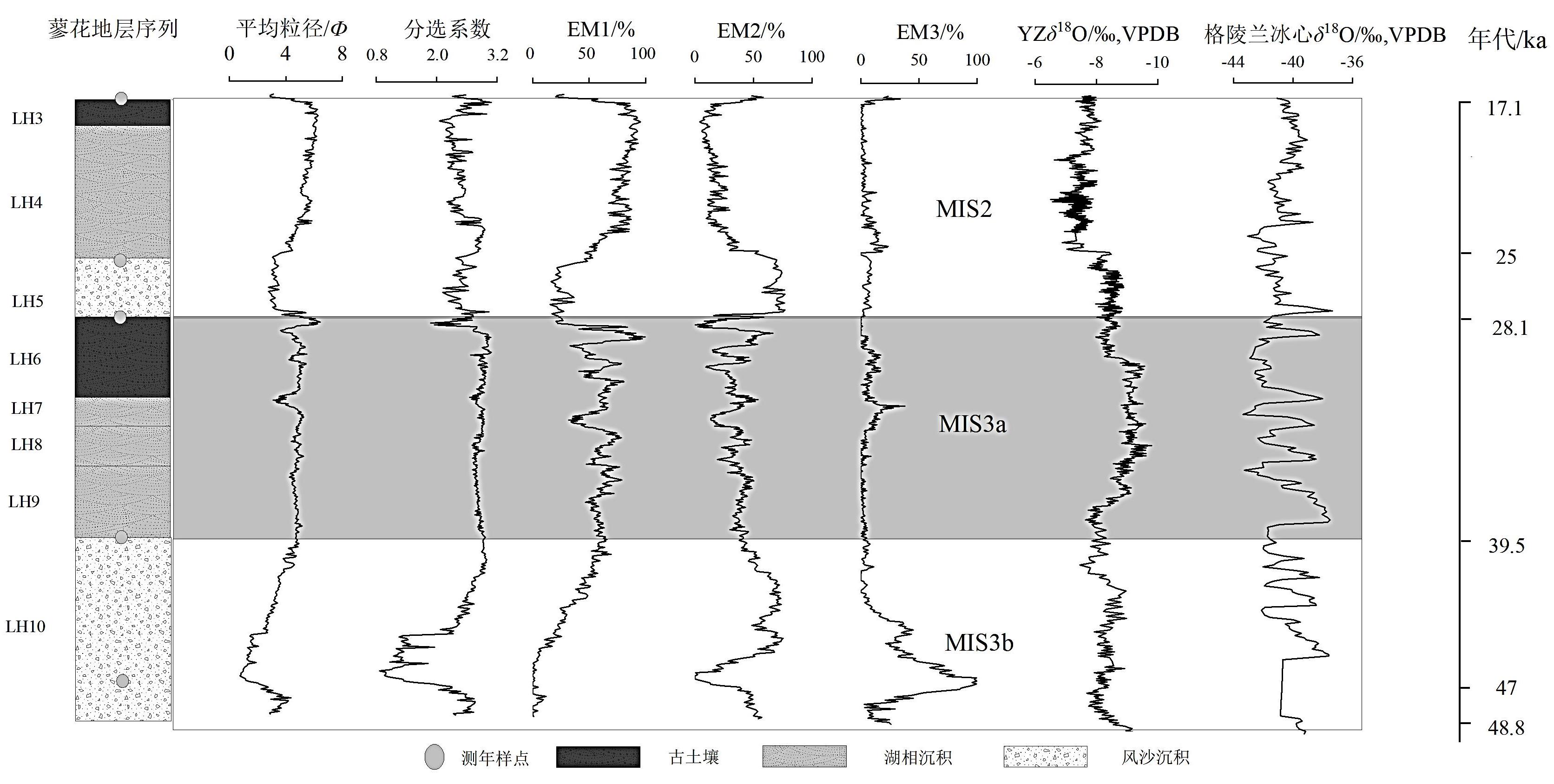
Late Quaternary aeolian sediment sequences are widely distributed in the Poyang Lake area and are good subjects for climate evolution research. However, previous studies have focused mainly on aeolian sediments and less on lacustrine facies and their overlapping accumulation with aeolian sands. Therefore, after field investigations in Shaling Mountain, Xingzi County, the Liaohua section was selected as the study area where we tested the geological age and grain size, analyzed the grain size results by end-member analysis model, and compared the end-member component content with the average grain size and standard deviation. Oxygen isotopes of stalagmites in YZ Cave, Chongqing, and Greenland ice core records were analyzed. We also discussed the climate change law in the middle and late periods of the last glacial period in this area to source basic data for the response of the last glacial deposits in the Poyang Lake area to the East Asian monsoon and even the whole world. The results show the following: 1) This section is composed of lake facies, ancient soil, dune sand, and other sedimentary facies. Combined with the dating results and deep-sea oxygen isotope records, a chronological-depth framework based on the piecewise sedimentation rate interpolation method was constructed. The dating results show that this profile was formed in the middle and late glacial stage (48.8-17.1 ka) and the grain size was mainly silt, medium sand, and fine sand. Clay was higher in the paleosol or lacustrine layer, and coarse sand had the highest volume fraction in the dune sand layer. 2) The end-member analysis model separates the granularity data into three different granularity end-members ( EM1, EM2, and EM3). The contents of different end-member components in different strata are obviously different. EM1 represents the end-member components of silt, and the peak values correspond to the development period of lacustrine facies and paleosol. EM2 and EM3 represent the end-member components of medium sand and coarse sand, respectively, and the peak values correspond to the dune sand development period. 3) The end volume fraction and average particle size sorting coefficient show obvious peak-valley alternations on the profile, and the alternation of these peak-valley cycles represents monsoon evolution and climate fluctuation in the last glacial period. On the scale of 10,000 years, the strong winter monsoon periods are LH10 (48.8-39.9 ka) and LH3-LH5 (28.1-17.1 ka), which correspond to the peak areas of EM2 and EM3. Dune sand has a high coarse grain content, small standard deviation, and good sorting, corresponding to the MIS3b and MIS2 stages of deep-sea oxygen isotopes, respectively. LH6-LH9 (39.9-28.1 ka) is a warm summer monsoon period, corresponding to the peak area of EM1, lacustrine deposition and paleosol development, many fine particle components, large standard deviation, and poor sorting, which corresponds to the MIS3a stage of deep-sea oxygen isotopes. These changes correspond with the changes in oxygen isotopes of stalagmites in the YZ cave and Greenland ice cores, which is consistent with global climate change.
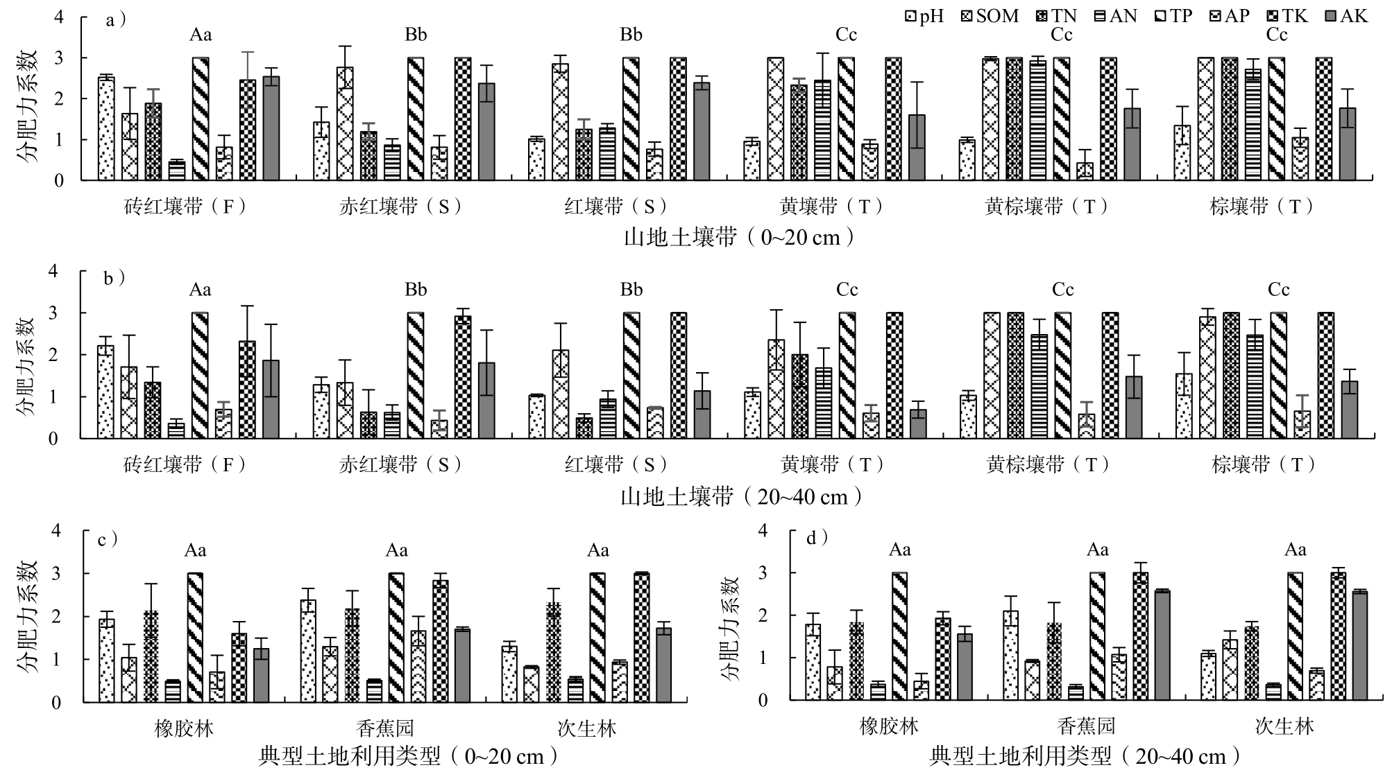
This study was conducted to gain insight into the distribution characteristics of Soil Organic Matter (SOM) and Soil Integrated Fertility (SIF) in various mountain soil zones and several typical land use types (secondary forest, banana plantation, and rubber plantation) on different altitude gradients in the northern tropics and the Butterfly Valley area in Jinping County, Yunnan Province, China. The surface (0-20 cm) and subsurface (20-40 cm) layers are distinguished. SOM, pH, total N, total P, total K, and available N, P, and K were measured. The SIF was evaluated using the modified Nemorow index method, and the key limiting factors were analyzed. First, the results show that the SOM content ranges from 21.91 to 120.67 g/kg for the surface layer and 16.38 to 101.88 g/kg for the subsurface layer, with the mean SOM of the surface layer (75.32 g/kg) greater than that of the subsurface layer (51.57 g/kg, P > 0.05). In terms of SIF, that of the surface layer was 1.15-1.59 and that of the subsurface layer was 0.94-1.44, with the mean SIF of the surface layer (1.35) greater than that of the subsurface layer (1.16). This shows that there is a significant positive correlation between the altitude gradient and SOM as well as SIF. Ranking of SOM and SIF for the surface layer (P < 0.05). Second, the SOM for the surface layer of the secondary forest, banana plantation, and rubber plantation were 26.61, 13.48, and 11.91 g/kg, respectively, while the SOM for the subsurface layer of these three typical land use types are 19.28, 9.61, and 8.91 g/kg, respectively. With regard to SIF, they were 1.48, 1.33, and 1.21 for the surface layer, and 1.17, 1.10, and 0.94, respectively. Notably, both in the surface and subsurface layers, the SOM and SIF were largest in the secondary forest, followed by the banana plantation, and then the rubber plantation. The SOM of the secondary forest was significantly greater than that of the banana and rubber plantations (P < 0.05), whereas there was no significant difference among the SIF of these three land use types. Finally, as the altitude increased, the factors limiting the SIF change from available N and available P to available P and available K, and the effect of pH gradually strengthened. The factors that maintain and limit the SIF of different land use types at low altitudes are generally consistent with natural soils at the same altitude. Therefore, in the process of future mountain development and utilization, it is important for low-altitude areas to supply nitrogen and phosphate to the soil. In medium- and high-altitude areas, supplementation with phosphate and potash is useful, and a suitable pH helps the soil release nutrients and promotes plant uptake and utilization.
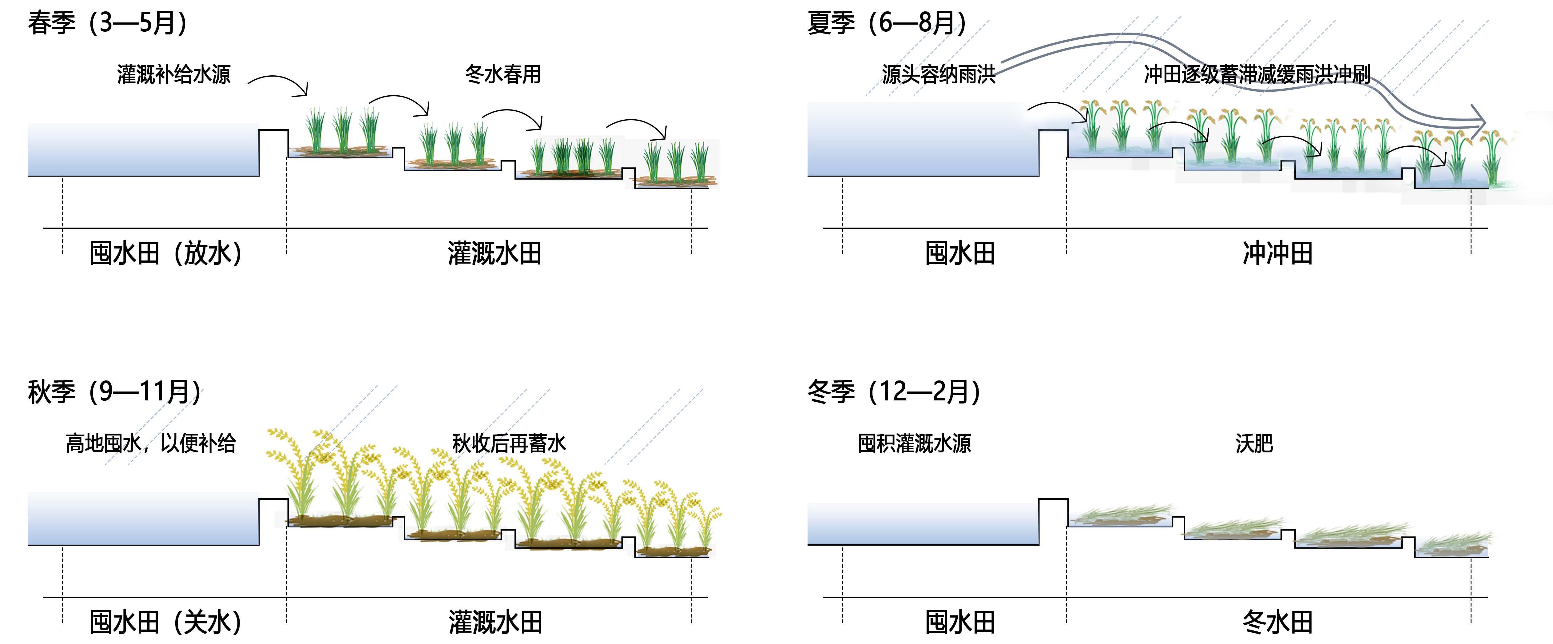
The Bayu terraced human settlement is an on-site living cultural heritage site that responds to natural features such as mountainous landforms and seasonal hydrology. Research into the site selection, technology, and combination of Bayu terraced human settlements can provide historical insight for the construction of resilient urban and rural developments in the southwest mountainous areas and the simultaneous protection of small and micro wetlands. Complete and representative remote sensing images of terraced fields in the Bayu area, combined with historical data analysis and field investigation using the visual landscape schema language, this study analyzed the single-terraced water conservancy technology, the spatiotemporal combination model of this technology, and the three construction characteristics of the terraced human settlement environment. As a result, the landscape schema system of the Bayu-terraced human settlement system was constructed. First, the research found that, in response to the Bayu Mountain topography and the rainfall characteristics of "spring drought and summer flood," a series of in-terrain terraced water conservancy technologies have been formed, such as winter paddy field for the autumn and spring, flushing fields for flood discharge in the summer, and hoarding paddy fields for closing water in all seasons. Second, Bayu terraced water conservancy technology forms a water resource management model of "autumn storage, winter fertility, spring ploughing, summer drainage" adapted to "spring drought and summer flooding", and a combination of "high storage, low irrigation" that conforms to the geomorphology that is formed. Finally, the terraced human settlement responds to the difference in water safety under the influence of geomorphology, presenting an "organic dispersion type" terraced human settlement pattern in low-mountainous hilly areas where the intersecting terraced base and the conservation forest and the scattered residential patches nest occlusion. The conservation forest is a "large area concentration type" terraced human settlement pattern in low-mountainous hilly areas where the intersecting terraced base and the conservation forest and the scattered residential patch nest in occlusion. In summary, Bayu terraced water conservancy technology types, combination methods, and the construction mode of terraced human settlements in mountainous topography integrate with Bayu's unique geographical geomorphology and hydrological conditions. These are important for the current low-impact development and construction of urban and rural areas and the protection of traditional construction wisdom. There are also positive references.
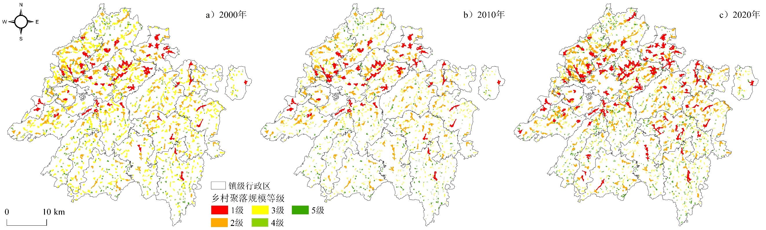
In the context of social transformation and urbanization, rural settlements have undergone drastic changes, and some rural settlements, including characteristic settlements, have been declining or even dying out. Research on scale and grade evolution is essential for the optimization of rural settlement spatial patterns and the protection of characteristic settlements. Based on the data of rural settlement patches in Xixiu District in 2000, 2010, and 2020, this study investigates the distribution characteristics and evolution of rural settlement scale in Xixiu District, and analyzes the development and changes occurring in Tunpu settlement during this process by using the rural rank-size rule and settlement scale hierarchy model. The main conclusions are as follows: (1)Overall, the total scale and number of rural settlements show an increasing trend, and the scale of Tunpu settlements continues to increase. The area of Tunpu settlement accounted for more than 20% of the total area of rural settlements in the three periods. (2)The scale distribution of rural settlements in Xixiu District was in accordance with the law of rural rank size. The theoretical values of most rural settlements differ minimally from the actual values, the fitting degree is gradually improved, and the negative exponential distribution characteristics gradually become prominent, showing the distribution characteristics of "first settlement" and "vertical tail." The scale of rural settlements tended to be concentrated in 2000-2010 and balanced in 2010-2020. (3) The spatial distribution of rural settlements in the different grades was relatively stable. The first- and second-grade settlements were mainly distributed in areas with small relief and developed economies, the third-grade settlements were evenly distributed in the area, and the fourth- and fifth-grade settlements were distributed in areas with large relief. The number has evolved from low to high, and at the same time, small-scale and scattered settlements quickly fill the 5-level settlements. Simultaneously, small-scale and scattered settlements quickly fill the 5-level settlements. (4) The Tunpu settlement is an important high-rank and high-scale settlement in Xixiu District. The scale growth of the Tunpu settlement with high rank shows stability, while the scale growth of the Tunpu settlement with low rank shows instability, and the development of rank shows retrogression. There are differences in the scale and grade of development of Tunpu settlements at different military levels. The higher the military level, the better the regional conditions and the higher the scale and grade development of settlements. In the future, Xixiu District should focus on rectifying small-scale and scattered settlement patches, optimizing the layout of settlement land, Playing the role of "leading" settlements, and forming a scientific and reasonable rural settlement scale structure. The development of the Tunpu settlement in the Xixiu District is facing a series of problems. This study discusses the changes in the scale of rural settlements in the study area, which provides a realistic foundation for the classification and protection of Tunpu settlements and the creation of regional characteristic settlements. Additionally, it provides new perspectives for research on the scale of rural settlements and the protection of characteristic settlements.