
1987—2017年海南岛海岸线变化特征遥感分析
|
张丽(1975—),女,新疆伊犁人,研究员,主要从事植被生态和海岸带遥感研究,(E-mail)zhangli@aircas.ac.cn。 |
收稿日期: 2019-10-08
修回日期: 2020-04-30
网络出版日期: 2020-08-11
基金资助
海南省重大科技计划项目(ZDKJ2019006)
中国科学院战略性先导科技专项(A类)(XDA13020506)
Remote Sensing Analysis of Coastline Changes in Hainan Island during 1987-2017
Received date: 2019-10-08
Revised date: 2020-04-30
Online published: 2020-08-11
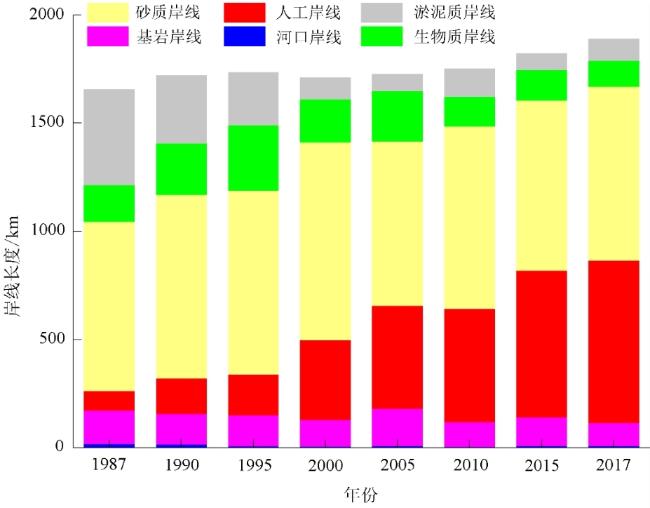
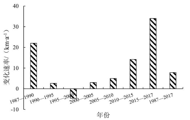
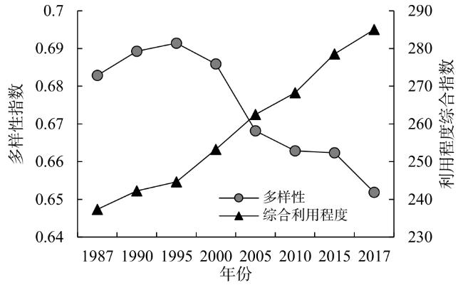
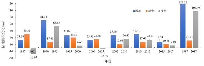
利用海岸线、红树林和近海围塘养殖等多个遥感专题信息产品,从岸线年均变化速率、利用率和综合利用程度等方面综合分析了海南岛1987—2017年的海岸线变化特征,并通过典型岸线类型变化探讨了人类活动对海南岛海岸带资源的影响。分析发现:1)海岸线长度总体呈稳定增长趋势。由1987年的1 655 km增至2017年的1 890 km,其中自然岸线持续减少,人工岸线急剧增长。2)岸线类型多样性降低,倾向性明显;而岸线的利用程度不断提高,利用程度综合指数由1987年的237.34增加到2017年的285.03,人类活动对海岸线变迁的干扰作用越来越明显。3)陆海格局变化特征复杂,整体呈向海扩张的态势。多种人为因素共同作用是导致岸线不断变迁的主要原因,人工养殖塘的开发使红树林湿地遭到侵占,生物岸线减少,港口建设、近海人工岛建设等引起砂质岸线等自然岸线减少。
张丽 , 廖静娟 , 袁鑫 , 穆晓东 , 宋茜茜 , 毕京鹏 . 1987—2017年海南岛海岸线变化特征遥感分析[J]. 热带地理, 2020 , 40(4) : 659 -674 . DOI: 10.13284/j.cnki.rddl.003260
Coastal zone of Hainan is one of the most valuable areas of natural resources and also forms a good ecological environment. Based on a 30-years coastal data derived from satellite imagery, which includes coastline, mangrove, nearshore aquaculture ponds, artificial islands, and ports, this study analyzed the coastline changes and other spatial elements in the coastal zone of Hainan Island. The human activities that impacted on the coasts of Hainan were also evaluated. The indices used for the analysis were: Length Change Intensity (LCI), Index of Coastline Type Diversity (ICTD), and Index of Coastline Utilization Degree (ICUD). In this study, we found that: 1) the length of the coastline increased steadily from 1,655 km (in 1987) to 1,890 km (in 2017). In contrast, the natural coastline length decreased continuously from 1,565 km (in late 1980s) to 1,140 km (in 2017), with a proportion drop from 94.6% to 60.3%. The length and proportion of artificial shoreline increased remarkably, from 90 km (in late 1980s) up to 750 km (in 2017) and a proportion changed from 5.40% to 39.7%. 2) The diversity of coastline types decreased while the coastline utilization degree increased. From 1987 to 2017, the ICUD increased continuously from 237.34 to 285.03, indicating that human activities had an increasing effect on coastline changes. 3) Land and sea pattern changes were complicated, with the coastline expanding into the sea. Overall, the coastal land area increased by 107.49 km. A variety of human factors contribute for the continuous changes of the coastline. The change in the biotic coastline is mainly the result of competition between mangroves and aquaculture ponds, and the construction of ports and offshore artificial islands, which are also responsible for the land sea pattern reform. Since 2000, the length of the coastline of Hainan Island has increased largely due to the coastal construction projects that have augmented the artificial shoreline. Currently, it is still necessary to strengthen the protection and control of coastlines and promote their sustainable utilization. With the increase in general awareness about environmental protection laws and the implementation of coastal zone management and ecological restoration protocols, the coastal ecological environment will be largely protected and restored. This study contributes to a better understanding of the ecological environmental changes in the coastal zone of Hainan and provides scientific basis for the protection and restoration of its ecological environment. The study provides a scientific application paradigm for the effective use of coastal datasets to conduct research on the coastal environment.
表1 采用的海岸带数据集基本信息Table 1 Information of the coastal data set in this study |
| 数据集 | 卫星数据 | 提取方法 | 精度评估/% | 分辨率/m | 时间跨度 | 数据来源 |
|---|---|---|---|---|---|---|
| 岸线变化和类型 | Landsat | 目视解译 | 95 | 30 | 8期:1987、1990、1995、2000、2005、2010、2015、2017年 | 毕京鹏等(2019) |
| 红树林 | Landsat | 支持向量机 | 99① | 30 | 7期:1987、1993、1998、2003、2007、2013、2017年 | 廖静娟等(2019) |
| 围塘养殖 | Landsat | 面向对象 | 97 | 30 | 4期:1990、2000、2010、2015年 | 袁鑫等(2020)② |
| 近海人工岛 | Landsat / GF-1/GF-2 | 目视解译 | 97 | 30/ 1~2 | 4期:2010、2014、2015、2016年 | 张云飞等(2020) |
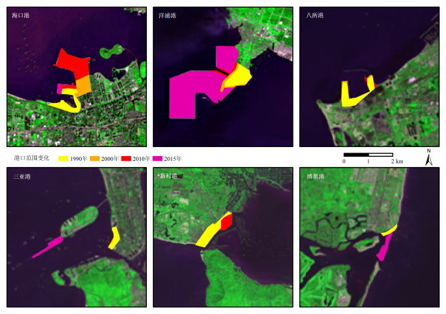
| 港口变化 | Landsat | 目视解译 | 82 | 30 | 4期:2000、2005、2010、2015年 | 毕森等(2017) |
|
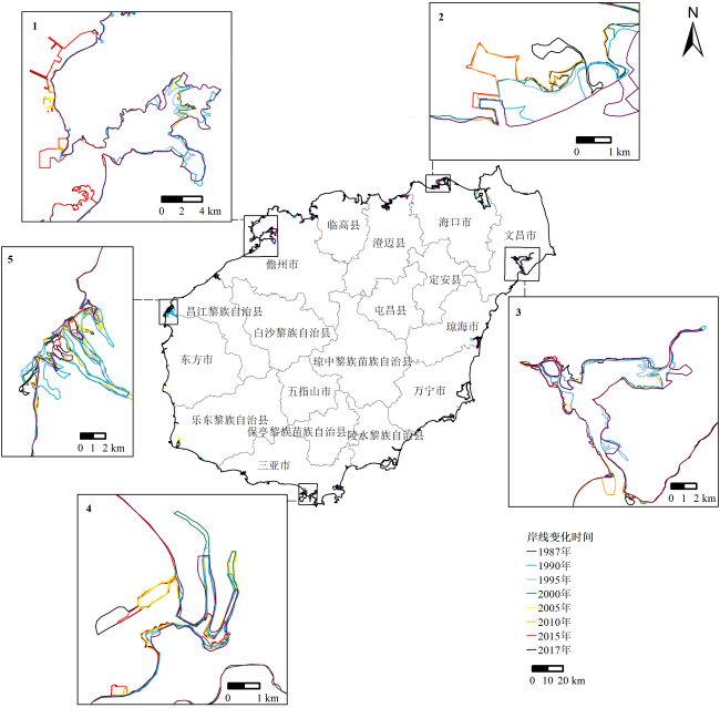
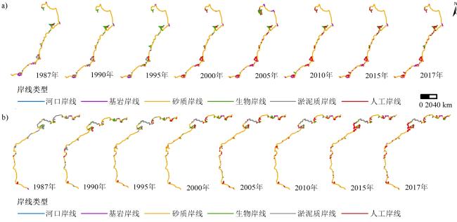
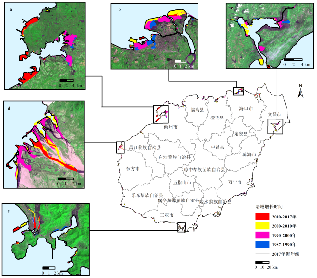
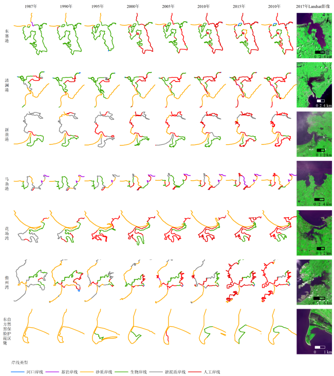
图4 1987—2017年海南岛东部(a)、西部(b)岸段岸线类型变化Fig.4 Shoreline's types in the eastern (a) and western (b) parts of Hainan Island during 1987-2017 |
表2 1987—2017年海南岛各类型岸线长度比例和变化速率Table 2 Length proportion and annual change rate for shorelines in Hainan Island during 1987-2017 |
| 年 份 | 自然岸线 | 人工岸线 | ||||||||||||||||||
|---|---|---|---|---|---|---|---|---|---|---|---|---|---|---|---|---|---|---|---|---|
| 河口岸线 | 基岩岸线 | 砂质岸线 | 生物岸线 | 淤泥质岸线 | 小计 | |||||||||||||||
| 比例 % | 变化速率(km·a-1) | 比例 % | 变化速率(km·a-1) | 比例 % | 变化速率(km·a-1) | 比例 % | 变化速率(km·a-1) | 比例 % | 变化速率(km·a-1) | 比例 % | 变化速率(km·a-1) | 比例 % | 变化速率(km·a-1) | |||||||
| 1987 | 1.0 | — | 9.4 | — | 47.3 | — | 10.2 | — | 26.6 | — | 94.6 | — | 5.4 | — | ||||||
| 1990 | 0.9 | -0.3 | 8.1 | -5.0 | 49.2 | 21.3 | 13.8 | 23.0 | 18.3 | -42.0 | 90.4 | -3.0 | 9.6 | 25.0 | ||||||
| 1995 | 0.4 | -1.8 | 8.2 | 0.6 | 49.0 | 0.4 | 17.4 | 12.8 | 14.1 | -14.2 | 89.1 | -2.2 | 10.9 | 4.8 | ||||||
| 2000 | 0.4 | -0.2 | 7.1 | -4.2 | 53.4 | 13.0 | 11.6 | -20.8 | 5.9 | -28.6 | 78.4 | -40.8 | 21.6 | 36.2 | ||||||
| 2005 | 0.5 | 0.4 | 10 | 10.2 | 44.0 | -30.8 | 13.4 | 6.8 | 4.5 | -4.6 | 72.5 | -18.0 | 27.5 | 21.0 | ||||||
| 2010 | 0.2 | -0.8 | 6.5 | -11.8 | 48.1 | 16.6 | 7.8 | -19.0 | 7.4 | 10.2 | 70.1 | -4.8 | 29.9 | 9.8 | ||||||
| 2015 | 0.4 | 0.8 | 7.3 | 3.8 | 43.1 | -11.4 | 7.7 | 0.8 | 4.2 | -10.6 | 62.8 | -16.6 | 37.2 | 30.8 | ||||||
| 2017 | 0.4 | 0 | 5.7 | -13.0 | 42.5 | 8.5 | 6.3 | -10.5 | 5.4 | 13.0 | 60.3 | -2.0 | 39.7 | 36.0 | ||||||
表3 1987—2017年海南岛红树林湿地重点保护区分布面积、变化量和变化速率Table 3 Area, variation, and change rate of mangrove in Reserves of Hainan Island during 1987-2017 |
| 地区 | 统计量 | 1987年 | 1993年 | 1998年 | 2003年 | 2007年 | 2013年 | 2017年 |
|---|---|---|---|---|---|---|---|---|
| 东寨港 | 面积/km2 | 14.66 | 15.32 | 16.12 | 16.66 | 17.29 | 17.88 | 17.33 |
| 变化量/(km2·a-1) | — | 0.11 | 0.16 | 0.11 | 0.16 | 0.10 | -0.14 | |
| 变化速率/% | — | 0.7 | 1.0 | 0.7 | 0.9 | 0.6 | -0.8 | |
| 清澜港 | 面积/km2 | 16.56 | 14.47 | 13.28 | 11.65 | 11.50 | 12.14 | 11.74 |
| 变化量/(km2·a-1) | — | -0.35 | -0.24 | -0.33 | -0.04 | 0.11 | -0.10 | |
| 变化速率/% | — | -2.2 | -1.7 | -2.6 | 0.3 | 0.9 | -0.8 | |
| 新盈港 | 面积/km2 | 4.15 | 3.30 | 3.05 | 2.94 | 2.63 | 2.76 | 2.91 |
| 变化量/(km2·a-1) | — | -0.14 | -0.05 | -0.02 | -0.08 | 0.02 | 0.04 | |
| 变化速率/% | — | -3.8 | -1.6 | -0.8 | -2.7 | 0.8 | 1.3 | |
| 马袅港 | 面积/km2 | 0.66 | 0.56 | 0.34 | 0.46 | 0.51 | 0.96 | 0.96 |
| 变化量/(km2·a-1) | — | -0.02 | -0.05 | 0.02 | 0.01 | 0.08 | 0.00 | |
| 变化速率/% | — | -2.7 | -10.1 | 6.0 | 2.6 | 10.6 | 0.2 | |
| 花场湾 | 面积/km2 | 4.54 | 3.97 | 3.41 | 2.57 | 2.19 | 3.22 | 3.00 |
| 变化量/(km2·a-1) | — | -0.1 | -0.11 | -0.19 | -0.10 | 0.17 | -0.05 | |
| 变化速率/% | — | -2.2 | -3.0 | -5.7 | -4.0 | 6.4 | -1.7 | |
| 新英湾 | 面积/km2 | 6.23 | 7.60 | 7.23 | 4.83 | 4.78 | 5.77 | 6.07 |
| 变化量/(km2·a-1) | — | 0.23 | -0.08 | -0.48 | -0.01 | 0.17 | 0.08 | |
| 变化速率/% | — | 3.3 | -1.0 | -8.1 | -0.3 | 3.1 | 1.3 | |
| 东方 | 面积/km2 | 0.36 | 0.25 | 0.38 | 0.30 | 0.60 | 0.67 | 0.77 |
| 变化量/(km2·a-1) | — | -0.02 | 0.03 | -0.02 | 0.08 | 0.01 | 0.02 | |
| 变化速率/% | — | -6.1 | 8.5 | -5.1 | 17.7 | 1.8 | 3.3 | |
| 总计 | 面积/km2 | 47.16 | 45.47 | 43.81 | 39.40 | 39.50 | 43.40 | 42.78 |
| 变化量/(km2·a-1) | — | -0.28 | -0.33 | -0.88 | 0.02 | 0.65 | -0.15 | |
| 变化速率/% | — | -0.6 | -0.7 | -2.1 | 0.1 | 1.6 | -0.4 |
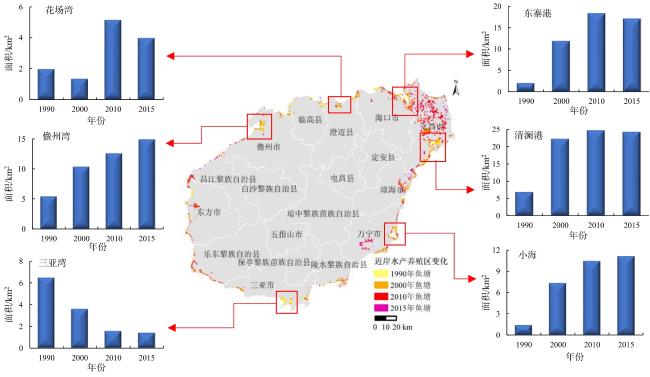
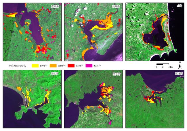
图10 1990—2015年海南岛养殖塘重点监测区面积变化Fig.10 Changes in the area of coastal aquaculture ponds in Hainan Island during 1990-2015 |

|
包萌.2014.近40年间海南岛海岸线遥感监测与变迁分析.呼和浩特:内蒙古师范大学.[Bao Meng.2014.Monitoring and Analyzing Hainan Island Coastline Dynamic Using Remote Sensing Imagery in Recent 40 Years.Huhehaote: Inner Mongolia Normal University.]
|
|
毕京鹏,张丽,宋茜茜,隋燕,温礼.2019.1987—2017年海南岛8期海岸线数据集.中国科学数据,4(2):1-11.[Bi Jingpeng, Zhang Li, Song Xixi, Sui Yan and Wen Li.2019.Coastline Dataset of Hainan Island During 1987-2017.China Scientific Data, 4(2): 1-11.]
|
|
毕森,王恒,张丽,李通,刘东,韩瑞丹.2017.基于不透水面的海南港口城市扩张分析.应用科学学报,35(3):346-354.[Bi Sen, Wang Heng, Zhang Li, Li Tong, Liu Dong and Han Ruidan.2017.Analysis of Expansion of Port Cities in Hainan Province Based on Impervious Surface.Journal of Applied Sciences (Electronics and Information Engineering), 35(3): 346-354.]
|
|
操戈,邓卫哲,徐承旭.2017.海南大力发展深海网箱养殖.水产科技情报,44(2):109.[Cao Ge, Deng Weizhe and Xu Chengxu.2017.Hainan Vigorously Develops Deep Sea Cage Culture.Fisheries Science & Technology Information, 44(2): 109.]
|
|
Chen Shuisen, Chen Liangfu, Liu Qinhuo, Li Xia and Tan Qiyu.2005.Remote Sensing and GIS-Based Integrated Analysis of Coastal Changes and Their Environmental Impacts in Lingding Bay, Pearl River Estuary, South China.Ocean & Coastal Management, 48: 65-83.
|
|
国家海洋局.2017.《海岸线保护与利用管理办法》.(2017-03-31)[2017-04-17].http://www.chinalawedu.com/falvfagui/22016/jx1704178778. shtml.[State Oceanic Administration.2017.Management Measures for Protection and Utilization of Coastline.(2017-03-31) [2017-04-17].http://www.chinalawe du.com/falvfagui/22016/jx1704178778.shtml.]
|
|
侯西勇,刘静,宋洋,李晓炜.2016.中国大陆海岸线开发利用的生态环境影响与政策建议.中国科学院院刊,31(10):1143-1150.[Hou Xiyong, Liu Jing, SongYang and Li Xiaowei.2016.Environmental-Ecological Effect of Development and Utilization of China’s Coastline and Policy Recommendations.Bulletin of Chinese Academy of Sciences, 31(10): 1143-1150.]
|
|
Hou Xiyong, Wu Ting, Hou Wan, Chen Qing, Wang Yuandong and Yu Liangju.2016.Characteristics of Coastline Changes in Mainland China Since the Early 1940s. Science China (Earth Sciences), 59(9): 1791-1802.
|
|
Kilian Vos, Kristen Splinter, Mitchell D Harley, Joshua Simmons and Ian L Turner.2019.CoastSat: A Google Earth Engine-Enabled Python Toolkit to Extract Shorelines from Publicly Available Satellite Imagery.Environmental Modelling and Software, https://doi.org/10.1016/j.envsoft.2019.104528.
|
|
李刚,万荣胜,陈泓君,唐江浪,李波.2018.海南岛南部海岸线变迁及其成因.海洋地质前沿,34(1):48-54.[Li Gang, Wan Rongsheng, Chen Hongjun, Tang Jianglang and Li Bo.2018.Coastline Changes and Their Origin in the Southern Hainan Island.Marine Geology Frontiers, 34(1): 48-54.]
|
|
廖静娟,甄佳宁.2019.1987—2017年海南岛红树林变化数据集.中国科学数据,4(2):12-20.[Liao Jingjuan and Zhen Jianing.2019.Landsat Data of Mangrove Forest Changes in Hainan Island during 1987-2017.China Scientific Data, 4(2): 12-20.]
|
|
刘百桥,孟伟庆,赵建华,胡蓓蓓,刘利东,张丰收.2015.中国大陆1990—2013年海岸线资源开发利用特征变化.自然资源学报,30(12):2033-2044.[Liu Baiqiao, Meng Weiqing, Zhao Jianhua, Hu Beibei, Liu Lidong and Zhang Fengshou.2015.Variation of Coastline Resources Utilization in China from 1990 to 2013.Journal of Natural Resources, 30(12): 2033-2044.]
|
|
刘锡清.2005.我国海岸带主要灾害地质因素及其影响.海洋地质前沿,21(5):23-42.[Liu Xiqing.2005.Main Geological Hazardous Factors and Influences on China Coastal Zone.Marine Geology Frontiers, 21(5): 23-42.]
|
|
罗琳,舒廷飞,温琰茂.2002.水产养殖对近海生态环境的影响.水产科学,(3):28-30.[Luo Lin, Shu Tingfei and Wen Yanmao.2002.Effects of Aquaculture on Coastal Ecological Environment.Fisheries Science, 21 (3): 28-30.]
|
|
Meng Weiqing, Hu Beibei, He Mengxuan, Liu Baiqiao and Zhang Yu.2017.Temporal-Spatial Variations and Driving Factors Analysis of Coastal Reclamation in China.Estuarine, Coastal and Shelf Science, 191: 39-49.
|
|
Mujabar P S and Chandrasekar N.2013.Shoreline Change Analysis along the Coast between Kanyakumari and Tuticorin of India Using Remote Sensing and GIS.Arabian Journal of Geosciences, 6(3): 647-664.
|
|
Natesan Usha, Thulasiraman N, Deepthi K and Kathiravan K.2013.Shoreline Change Analysis of Vedaranyam Coast, Tamil Nadu, India.Environmental Monitoring and Assessment, 185 (6): 5099-5109.
|
|
隋燕.2018.基于遥感的海南岛近30年海岸线时空变迁监测与分析.青岛:山东科技大学.[Sui Yan.2018.Monitoring and Analysis of Spatial-Temporal Changes of Coastline in Hainan Island in Resent 30 Years Based on Remote Sensing.Qingdao: Shandong University of Science and Technology.]
|
|
Sagheer A A, Humade A and Al-Jabali A M O.2011.Monitoring of Coastline Changes along the Red Sea, Yemen Based on Remote Sensing Technique.Global Geology, 14(4): 241-248.
|
|
Tian Bo, Wu Wenting, Yang Zhaoqing and Zhou Yunxuan.2016.Drivers, Trends, and Potential Impacts of Long-Term Coastal Reclamation in China from 1985 to 2010.Estuarine, Coastal and Shelf Science, 170: 83-90.
|
|
Tran Thi V, Tien Thi Xuan A, Phan Nguyen H, Dahdouh-Guebas1 F and Koedam N.2014.Application of Remote Sensing and GIS for Detection of Long-Term Mangrove Shoreline Changes in Mui Ca Mau, Vietnam.Biogeosciences, 11: 3781-3795.
|
|
王建步,张杰,陈景云,孙伟富,马毅.2015.近30余年辽河口海岸线遥感变迁分析.海洋环境科学,34(1):86-92.[Wang Jianbu, Zhang Jie, Chen Jingyun, Sun Weifu and Ma Yi.2015.Analysis of the Liaohe Estuary Coastline Changes Basing on the Remote Sensing Image in the Past Thirty Years.Marine Environmental Science, 34(1): 86-92.]
|
|
Wang Xinxin, Xiao Xiangming, Zou Zhenhua, Hou Luyao and Li Bo.2020.Mapping Coastal Wetlands of China Using Time Series Landsat Images in 2018 and Google Earth Engine.ISPRS Journal of Photogrammetry and Remote Sensing, 163: 312-326.
|
|
吴培强,张杰,马毅,李晓敏.2013.近20a来我国红树林资源变化遥感监测与分析.海洋科学进展,31(3):406-414.[Wu Peiqiang, Zhang Jie, Ma Yi and Li Xiaomin.2013.Remote Sensing Monitoring and Analysis of the Changes of Mangrove Resources in China in the Past 20 Years.Advances in Marine Science, 31(3): 406-414.]
|
|
毋亭.2016.近70年中国大陆岸线变化的时空特征分析.烟台:中国科学院烟台海岸带研究所.[Wu Ting.2016.Analysis of Spatio-Temporal Characteristics of Mainland Coastline Changes in China in Nearly 70 Years.Yantai: Yantai Institute of Coastal Zone Research, Chinese Academy of Science.]
|
|
Wu Ting, Hou Xiyong and Xu Xinliang.2014.Spatio-Temporal Characteristics of the Mainland Coastline Utilization Degree over the Last 70 Years in China.Ocean and Coastal Management, 98: 150-157.
|
|
吴岩峻,张京红,田光辉,蔡大鑫,刘少军.2006.利用遥感技术进行海南省水产养殖调查.热带作物学报,27(2):108-111.[Wu Yanjun, Zhang Jinghong, Tian Guanghui, Cai Daxin and Liu Shaojun.2006.A Survey to Aquiculture with Remote Sensing Technology in Hainan Province.Chinese Journal of Tropical Crops, 27 (2): 108-111.]
|
|
辛欣,宋希强,雷金睿,方赞山,孟千万.2016.海南红树林植物资源现状及其保护策略.热带生物学报,7(4):477-483.[Xin Xin, Song Xiqiang, Lei Jinrui, Fang Zanshan and Meng Qianwan.2016.Mangrove Plants Resources and Its Conservation Strategies on Hainan.Journal of Tropical Biology, 7(4): 477-483.]
|
|
徐谅慧,李加林,李伟芳,赵斯,袁麒翔,王明月,杨磊,卢雪珠.2014.人类活动对海岸带资源环境的影响研究综述.南京师大学报(自然科学版),37(3):124-131.[Xu Lianghui, Li Jialin, Li Weifang, Zhao Si, Yuan Linxiang, Wang Mingyue, Yang Lei and Lu Xuezhu.2014.Progress in Impact of Human Activities on Coastal Resource and Environment.Journal of Nanjing Normal University (Natural Science Edition), 37(3): 124-131.]
|
|
杨忠兰.2004.福建九龙江河口湿地现状评价及保护对策.中南林业调查规划,23(3):40-43.[Yang Zhonglan.2004.Current Situation Evaluation and Protection Countermeasures of Wetland in Jiulong River Estuary, Fujian.Central South Forest Inventory and Planning, 23(3): 40-43.]
|
|
姚晓静,高义,杜云艳,季民.2013.基于遥感技术的近30a海南岛海岸线时空变化.自然资源学报,28(1):114-125.[Yao Xiaojing, Gao Yi, Du Yunyan and Ji Min.2013.Spatial and Temporal Changes of Hainan Coastline in the Past 30 Years Based on RS.Journal of Natural Resources, 28(1): 114-125.]
|
|
张云飞,杨昊翔,张丽,宋茜茜,毕京鹏,李杨.2020.基于DSAS和Gabor滤波增强的海南人工岛建设对砂质岸线变化的影响分析.江西理工大学学报,41(1):28-35.[Zhang Yunfei, Yang Haoxiang, Zhang Li, Song Xixi, Bi Jingpeng and Li Yang.2020.Analysis of the Influence of Hainan Artificial Island Construction on the Change of Sandy Shoreline Based on DSAS and Gabor Filter Enhancement.Journal of Jiangxi University of Science and Technology, 41(1): 28-35.]
|
|
赵锐,赵鹏.2014.海岸带概念与范围的国际比较及界定研究.海洋经济,4(1):58-64.[Zhao Rui and Zhao Peng.2014.Defining and International Comparing of the Conception and Scope of Coastal Zone.Marine Economy, 4(1): 58-64.]
|
|
周彦伶.2012.浅谈海南红树林的现状与保护.海南广播电视大学学报,(4):155-158.[Zhou Yanling.2012.On the Status Quo and Protection of Mangrove in Hainan.Journal of Hainan Radio & TV University, (4): 155-158.]
|
|
朱国强.2015.近30年南海周边国家海岸线时空变化研究.兰州:兰州交通大学.[Zhu Guoqiang.2015.Research on Spatial-Temporal Changes of Coastline in Countries around the South China Sea in Recent three Decades.Lanzhou: Lanzhou Jiaotong University.]
|
|
庄大方,刘纪远.1997.中国土地利用程度的区域分异模型研究.自然资源学报,(2):105-111.[Zhuang Dafang and Liu Jiyuan.1997.Study on the Model of Regional Differentiation of Land Use Degree in China.Journal of Natural Resource, (2): 105-111.]
|
/
| 〈 |
|
〉 |