
多元视野下的海南省临高县海岸带综合评估与深度空间管控探讨
|
邱彭华(1974—),男,湖南郴州人,博士,教授,主要研究方向为湿地科学、区域规划、华南地区环境生态及其管理,(E-mail)cphscnu@163.com; |
收稿日期: 2019-08-15
修回日期: 2020-08-26
网络出版日期: 2020-12-10
基金资助
海南省自然科学基金(418MS050)
国家自然科学基金(42061048)
海南省重大科技计划项目(ZDKJ2019006)
Comprehensive Assessment and Deep Spatial Management of Coastal Zone in Lingao County, Hainan Province from Multiple Viewpoints
Received date: 2019-08-15
Revised date: 2020-08-26
Online published: 2020-12-10
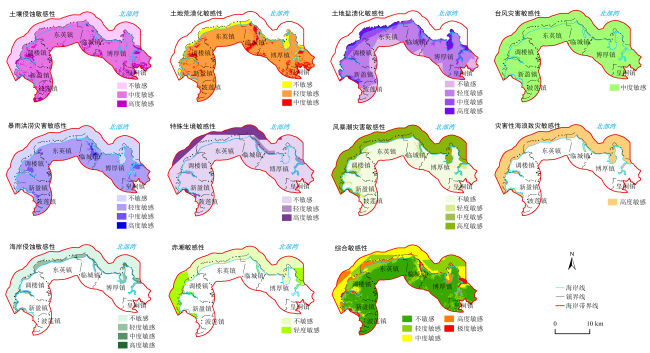
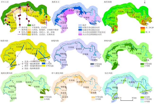
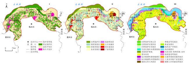
为进一步加强海岸带综合管理,探索更有效的空间管控方法,从各类生态环境敏感性的形成机理出发,通过选取代表性评价指标构建评价模型,综合评估了海南省临高县海岸带生态环境敏感性和地质灾害风险性,并将其与国土规划相结合,对研究区进行了深度空间管控分区分析。结果表明:1)土地荒漠化、土地盐渍化、暴雨洪涝、赤潮、海岸侵蚀均以轻度敏感为主,土壤侵蚀、台风灾害以中度敏感为主,特殊生境、风暴潮和灾害性海浪以高度敏感为主。综合敏感性轻度、中度、高度与极度敏感区面积分别为10 651.28、9 682.11、3 275.29和983.88 hm2,其中高度敏感区以调楼镇分布面积最大,极度敏感区以博厚镇分布最广;2)地质灾害以地震、崩塌、滑坡、地面沉降、砂土液化为主,除地震风险分为风险大区与中等区外,其余4种均只有中等风险区和风险小区,综合风险则有大、中等和小3个分级,其中风险大区主要分布于博厚、东英、波莲与皇桐镇的断裂带两侧各15 m范围区内,总面积为118.86 hm2;3)集生态敏感性、地质灾害风险与国土规划多元视野的海岸带深度空间管控分区,可较好地识别重要保护对象与关键保护区域,并使海岸带获得充分开发与利用。
邱彭华 , 杜娜 , 刘兵兵 , 杨星 , 谢跟踪 , 钟尊倩 . 多元视野下的海南省临高县海岸带综合评估与深度空间管控探讨[J]. 热带地理, 2020 , 40(6) : 1094 -1108 . DOI: 10.13284/j.cnki.rddl.003284
Sensitivity and risk assessments are not only effective methods for disaster prevention and alleviation but are also important bases for scientific spatial planning and regional environmental policy-formulation. To further strengthen the integrated management of coastal zone and explore more efficient methods of ecological space control, ten factors, namely soil erosion, desertification, soil salinization, typhoon disaster, rainstorm and flood disaster, special habitat, storm surge, disastrous wave, coastal erosion, and red tide, were selected to evaluate the eco-environmental sensitivity of the coastal zone in Lingao County, Hainan Province. Earthquake, collapse, landslide, land subsidence, and sand liquefaction were considered in the risk assessment of geological hazards. The results derived from eco-environmental sensitivity and risk assessment of geological hazards were combined with territorial planning to analyze the deep spatial management zoning of the study area. The results indicated that: 1) Desertification, soil salinization, rainstorm and flood disaster, red tide, and coastal erosion were mainly slightly sensitive; soil erosion and typhoon disaster were mainly moderately sensitive; and special habitat, storm surge, and disastrous wave were highly sensitive. The area of moderate, high, and extreme-high comprehensive sensitivity zone was 9 682.11, 3 275.29, and 983.88 hm2, respectively. Among them, Diaolou Town had the largest distribution area in the highly sensitive zone, and Bohou Town had the most widely distributed area in the extreme-highly sensitive zone. 2) The main geological hazards were earthquake, collapse, landslide, land subsidence, and sand liquefaction. Except for the seismic risk, which was divided into high-risk zone and middle zone, the other four types only had medium-risk and low-risk zones. The comprehensive risk zones were classified as high, medium, and low, among which the risk areas were mainly distributed in the 15 m area on each side of the fault zone of Bohou, Dongying, Bolian, and Huangtong Town, with a total area of 118.86 hm2. 3) The development and utilization of the coastal zone in Lingao County may be divided into three levels. The first level includes specific protected zone, moderate development zone, and intensive development zone. The second level included eight zones, including natural reserves, retention zone, utilization zone in control, agricultural development zone, tourism and leisure zone, public facility zone, residential construction zone, and industrial zone. The third level consisted of 18 tertiary divisions. 4) The deep spatial management zoning of the coastal zone with multiple horizons of ecological sensitivity, geological hazard risk, and territorial planning can better identify important protection objects and key protection areas and enable the coastal zone to be fully developed and utilized. Although this paper attempted to diagnose and identify the intensity and spatial distribution of various eco-environmental sensitivity types in the coastal zone from the views of quantification and visualization, some problems need to be explored further in the process of application, such as index selection, model construction, data acquisition, synergistic influence among different ecological environment sensitivity types, and so on. Moreover, the visual expression of geological hazard formation mechanism in the coastal zone and the commonness and individuality of the quantitative measurement of potential geological hazard risk assessment are also aspects that need to be strengthened.
表1 临高县海岸带生态环境敏感性类型及其计算模型Table 1 Types of ecological environmental sensitivity in Lingao County coastal zone and their calculation models |
| 敏感性类型 | 敏感性指数计算公式 | 参数说明 |
|---|---|---|
| 土壤侵蚀 | SSj为j空间单元土壤侵蚀敏感性综合指数;Cij为j单元i因子敏感性等级值;Wi为因子权重1)。参评因子:R值、土壤质地、地形起伏度和植被类型。 | |
| 土地荒漠化 | DSj为j空间单元荒漠化敏感性指数;Dij为j单元i因子敏感性等级值。参评因子:湿润指数、冬春季>6 m/s大风天数、土壤质地、植被覆盖(冬春)。 | |
| 土地盐渍化 | YSj为j空间单元土地盐渍化敏感性指数;Yij为j单元i因子敏感性等级值。参评因子:蒸发量/降雨量比值、浅层地下水位深度、地下水矿化度、地形。 | |
| 台风灾害 | TCSi为i空间单元台风灾害敏感性综合指数;Gi与Pi为i单元台风平均最大风力等级、台风频率的敏感性等级值,α、β为权重值2)。 | |
| 暴雨洪涝灾害 | RFSj为j空间单元暴雨洪涝灾害敏感性指数;Srij为j单元i因子敏感性等级值。参评因子:极值洪水位与地形相对高度关系、暴雨过程降水量频率、24 h暴雨过程降水强度极值。 | |
| 特殊生境 | HBSj为j空间单元生境敏感性指数;Spij为j单元i因子敏感性等级值。参评因子:被保护物种数量、被保护物种等级、被保护生态系统保护级别。 | |
| 风暴潮灾害 | STSj为j空间单元风暴潮灾害敏感性指数;Tj与Pj分别为j单元风暴增水极值与地形相对高度的对应关系、风暴潮平均年发生次数的敏感性等级值。 | |
| 灾害性海浪致灾 | SWSj为j空间单元灾害性海浪致灾敏感性指数;Hj、Nj为j单元海浪波高极值与地表及海面相对高度对应关系、灾害性海浪的平均年发生日数的敏感性等级值。 | |
| 海岸侵蚀 | CESj为j空间单元海岸侵蚀敏感性指数;Cij为j单元i因子的敏感性等级值。参评因子:海岸侵蚀速率、海岸类型、波浪作用水深。 | |
| 赤潮 | RTSj为j空间单元生境敏感性指数;Fj、Ej、Oj分别为j单元的历史赤潮发生频次、水体富营养化指数、扩散条件3个参评因子的敏感性等级值。 | |
| 综合敏感性 | S com j为第j评价单元的综合敏感性指数;Sij为第j评价单元第i敏感性类型评价指数值。 |
|
表2 临高县海岸带生态环境敏感性评价指标及其分级Table 2 Evaluation indices and classification of ecological environmental sensitivity in Lingao County coastal zone |
| 敏感性类型 | 参评指标 | 不敏感 | 轻度敏感 | 中度敏感 | 高度敏感 | 极敏感 | 参考文献 |
|---|---|---|---|---|---|---|---|
| 土壤 侵蚀 | R值/[m·t·cm·(hm-2· h-1·a-1)] | <25 | 25~100 | 100~400 | 400~600 | >600 | 景可等(2005) |
| 土壤质地 | 石砾、沙 | 粗砂土、细砂土、 黏土 | 面砂土、壤土、黏壤土、砂黏壤土 | 砂壤土、粉黏土、壤黏土 | 砂粉土、粉土 | 临高县农业局(1985); 龚子同等(2004) | |
| 地形起伏度/m | 0~50 | 50~100 | 100~200 | 200~300 | >300 | — | |
| 植被类型 | 草本沼泽、稻田、水体 | 阔叶林、针叶林、草甸、灌丛和萌生矮林、竹林 | 稀疏灌木草地、 一年二熟旱作 | 荒漠、一年 一熟旱作 | 无植被 | — | |
| 土地 荒漠化 | 湿润指数 | >0.65 | 0.50~0.65 | 0.20~0.50 | 0.05~0.20 | <0.05 | — |
| 冬春> 6 m/s 大风天数/d | <15 | 15~30 | 30~45 | 45~60 | >60 | 高素华(1988); 吴正等(1995) | |
| 土壤质地 | 基岩 | 黏质 | 砾质 | 壤质 | 沙质 | 临高县农业局(1985);龚子同等(2004) | |
| 植被覆盖(冬春) | 茂密 | 适中 | 较少 | 稀疏 | 裸地 | — | |
| 土地 盐渍化 | 蒸发量/降雨量 | <1 | 1~3 | 3~10 | 10~15 | >15 | — |
| 浅层地下水位深/m | >15 | 10~15 | 5~10 | 3~5 | <3 | 海南地质大队(1981) | |
| 地下水矿化度/(g·L-1) | <1 | 1~5 | 5~10 | 10~25 | >25 | ||
| 地形 | 二级及以上台地、丘陵 | 洪积平原、三角洲、一级台地 | 泛滥冲积平原 | 海积沙堤 | 滨海低平原、海积冲积平原 | — | |
| 台风 灾害 | 台风平均最大风力/级 | <6 | 6~8 | 8~10 | 10~12 | >12 | — |
| 台风频次1)/(次·a-1) | <0.1 | 0.1~0.3 | 0.3~0.6 | 0.6~0.9 | >0.9 | — | |
| 暴雨 洪涝 灾害 | 极值洪水位与地形 相对高度对应关系 | 高于极值高水位 | 低于极值高水位 1 m以内 | 低于极值高水位1~2 m以内 | 低于极值高水位2~3 m以内 | 低于极值高水位3 m以上 | 李文欢(2001); 温克刚等(2008); 张京红等(2010) |
| 暴雨过程降水量频率/(次·10a-1) | <5 | 5~10 | 10~20 | 20~30 | >30 | ||
| 24 h暴雨过程降水强度极值/mm | <50 | 50~100 | 100~200 | 200~300 | >300 | ||
| 特殊 生境 | 被保护物种数量/种 | 无 | 1~5 | 5~8 | 8~10 | >10 | 黄晖等(2012) |
| 被保护物种等级 | 无保护物种 | 地区性保护物种 | 其他国家与省级保护物种 | 国家二级 | 国家一级 | ||
| 被保护生态 系统级别 | 无级别 | 暂无级别,但专家认为应保护 | 市县级 | 省级 | 国家级 | ||
| 风暴潮灾害 | 风暴增水极值与地形 相对高度对应关系 | 高于增水 极值水位2) | 低于增水极值 水位1 m以内 | 低于增水极值 水位1~2 m以内 | 低于增水极值水位2~4 m以内 | 低于增水极值水位4 m以上 | 王红心(1998); 梁海燕等(2005); 王青颜等(2005); 石海莹(2013) |
| 平均年发生次数3) | <0.1 | 0.1~0.5 | 0.5~1 | 1~2 | >2 | ||
| 灾害性海浪 | 离海岸距离 | 宽于海浪波高极值 | 窄于海浪波高极值4 m以内 | 窄于海浪波高极值4~8 m以内 | 窄于海浪波高极值8~12 m以内 | 窄于海浪波高极值12 m以上 | 夏小明(2015); 麦卫斌(2018) |
| 平均年发生日数/d | <10 | 10~20 | 20~40 | 40~60 | >60 | ||
| 海岸 侵蚀 | 海岸侵蚀速率/(m·a-1) | <0.1 | 0.1~0.5 | 0.5~1.0 | 1.0~2.0 | >2.0 | 夏东兴等(1993); 黄巧华等(1997); 季荣耀(2007); 夏小明(2015) |
| 海岸类型 | 淤泥质、潟湖湾砂质、淤泥质岸段人工海岸 | 基岩、基岩段 人工海岸 | 非潟湖湾凹岸砂质、沙质岸段人工海岸 | 近平直岸砂质 | 凸岸砂质 | ||
| 波浪作用水深4) | >1.5个波高 | 1.1~1.5个波高 | 0.8~1.1个波高 | 0.4~0.8个波高 | <0.4个波高 | ||
| 赤潮 | 历史赤潮发生频次/次 | 无 | 1 | 2 | 3 | >3 | 周祖光(2013); 黄春等(2016); 李俊峰等(2017) |
| 水体富营养化指数5) | <0.5 | 0.5~1.0 | 1.0~2.0 | 2.0~.0 | >3.0 | ||
| 扩散条件 | 开阔海域 | 开敞度6)>0.4 | 0.2<开敞度≤0.4 | 0.1<开敞度≤0.2 | 开敞度≤0.1 | ||
| 赋分值 | 1 | 3 | 5 | 7 | 9 | — | |
| 分级标准 | 1.0~2.0 | 2.0~4.0 | 4.0~6.0 | 6.0~8.0 | >8.0 | — |
|
表3 临高县海岸带分类型敏感性分级区面积 (hm2)Table 3 Area of sensitive classification of coastal zones in Lingao County |
| 敏感性 类型 | 土地土壤类 | 气象灾害类 | 特殊生境类 | 海洋灾害类 | ||||||||||
|---|---|---|---|---|---|---|---|---|---|---|---|---|---|---|
| 土壤侵蚀 | 土地荒漠化 | 土地盐渍化 | 台风 | 暴雨洪涝 | 特殊生境 | 风暴潮 | 灾害性海浪 | 海岸侵蚀 | 赤潮 | |||||
| 合计 | 36 181.31 | 36 181.31 | 36 181.31 | 49 456.96 | 49 456.96 | 49 456.96 | 49 456.96 | 17 671.88 | 49 456.96 | 17 149.34 | ||||
| 不敏感 | 0.00 | 3 355.84 | 6 104.15 | 0.00 | 17 413.24 | 42 090 | 29 326.39 | 0.00 | 45 644.72 | 12 247.64 | ||||
| 轻度敏感 | 0.00 | 29 853.62 | 22 473.2 | 0.00 | 30 143.22 | 2 370.62 | 2 598.10 | 0.00 | 3 271.34 | 4 901.70 | ||||
| 中度敏感 | 32 441.94 | 2 971.85 | 4 387.45 | 49 456.96 | 1 802.98 | 0.00 | 366.11 | 0.00 | 371.11 | 0.00 | ||||
| 高度敏感 | 3 739.37 | 0.00 | 3 216.51 | 0.00 | 97.52 | 4 996.34 | 17 166.36 | 17 671.88 | 169.79 | 0.00 | ||||
| 极敏感 | 0.00 | 0.00 | 0.00 | 0.00 | 0.00 | 0.00 | 0.00 | 0.00 | 0.00 | 0.00 | ||||
|
表4 临高县海岸带综合敏感性分级统计 (hm2)Table 4 Comprehensive sensitivity classification statistics of coastal zone in Lingao County |
| 类型 | 波莲镇 | 博厚镇 | 东英镇 | 皇桐镇 | 临城镇 | 调楼镇 | 新盈镇 | 合计 | 占比2/% |
|---|---|---|---|---|---|---|---|---|---|
| 不敏感 | 1 844.70 | 7 901.22 | 4 813.59 | 842.39 | 2 490.65 | 3 084.60 | 3 887.24 | 24 864.40 | 50.27 |
| 轻度敏感 | 1.18 | 4 217.27 | 2 387.47 | 338.40 | 1 457.59 | 1 431.50 | 817.87 | 10 651.28 | 21.54 |
| 中度敏感 | 0.00 | 1 610.12 | 2 335.52 | 0.00 | 2 868.33 | 1 429.92 | 1 438.22 | 9 682.11 | 19.58 |
| 高度敏感 | 0.00 | 721.57 | 896.81 | 0.00 | 178.15 | 1 095.39 | 383.37 | 3 275.29 | 6.62 |
| 极度敏感 | 0.00 | 390.61 | 53.66 | 0.00 | 205.08 | 27.68 | 306.85 | 983.88 | 1.99 |
| 合计 | 1 845.88 | 14 840.79 | 10 487.05 | 1 180.79 | 7 199.80 | 7 069.09 | 6 833.55 | 49 456.96 | 100.00 |
| 占比1/% | 3.73 | 30.01 | 21.20 | 2.39 | 14.56 | 14.29 | 13.82 | 100.00 | — |
|
表5 临高海岸带地质灾害风险分级统计 (hm2)Table 5 Risk classification statistics of geological hazards in Lingao coastal zone |
| 镇名 | 地震风险 | 崩塌风险 | 滑坡风险 | 地面沉降风险 | 砂土液化风险 | 综合风险 | 合计 | |||||||||||||
|---|---|---|---|---|---|---|---|---|---|---|---|---|---|---|---|---|---|---|---|---|
| 大 | 中等 | 中等 | 小 | 中等 | 小 | 中等 | 小 | 中等 | 小 | 大 | 中等 | 小 | ||||||||
| 波莲镇 | 11.72 | 1 834.17 | 0.00 | 1 845.89 | 1 668.26 | 177.63 | 0.00 | 1 845.89 | 0.00 | 1 845.89 | 11.72 | 1 656.54 | 177.63 | 1 845.89 | ||||||
| 博厚镇 | 62.33 | 14 778.45 | 843.91 | 13 996.87 | 212.04 | 14 628.74 | 695.07 | 14 145.71 | 406.27 | 14 434.51 | 62.32 | 1 900.42 | 12 878.04 | 14 840.78 | ||||||
| 东英镇 | 15.74 | 10 471.31 | 276.18 | 10 210.87 | 2 347.58 | 8 139.47 | 0.00 | 10 487.05 | 1 368.23 | 9 118.82 | 15.74 | 2 368.36 | 8 102.95 | 10 487.05 | ||||||
| 皇桐镇 | 8.37 | 1 172.42 | 0.00 | 1 180.79 | 0.00 | 1 180.79 | 917.00 | 263.79 | 0.00 | 1 180.79 | 8.37 | 911.28 | 261.13 | 1 180.79 | ||||||
| 临城镇 | 0.00 | 7 199.80 | 287.85 | 6 911.95 | 1 870.19 | 5 329.61 | 131.72 | 7 068.08 | 1 834.93 | 5 364.87 | 0.00 | 2 068.28 | 5 131.52 | 7 199.80 | ||||||
| 调楼镇 | 0.00 | 7 069.10 | 290.76 | 6 778.34 | 927.65 | 6 141.45 | 0.00 | 7 069.10 | 682.66 | 6 386.44 | 0.00 | 933.59 | 6 135.51 | 7 069.10 | ||||||
| 新盈镇 | 20.71 | 6 812.84 | 422.37 | 6 411.18 | 1 385.43 | 5 448.12 | 0.00 | 6 833.55 | 909.54 | 5 924.01 | 20.64 | 1 585.12 | 5 227.79 | 6 833.55 | ||||||
| 小计 | 118.86 | 49 338.10 | 2 121.07 | 47 335.89 | 8 411.16 | 41 045.80 | 1 743.79 | 47 713.17 | 5 201.63 | 44 255.33 | 118.79 | 11 423.59 | 37 914.58 | 49 456.96 | ||||||
| 占比/% | 0.24 | 99.76 | 4.29 | 95.71 | 17.01 | 82.99 | 3.53 | 96.47 | 10.52 | 89.48 | 0.24 | 23.10 | 76.66 | 100.00 | ||||||
表6 临高县海岸带空间细化管控分区方案Table 6 Management and control plan for spatial refinement zoning of coastal zone in Lingao County |
| 一级分区名称 | 二级分区名称 | 三级分区名称 | 面积/hm2 | 占比/% |
|---|---|---|---|---|
| Ⅰ.特定 保护区 | Ⅰ-1 自然保护区 | Ⅰ-1-1 自然保护区核心区 | 2 127.25 | 4.30 |
| Ⅰ-1-2 自然保护区缓冲区 | 51.45 | 0.10 | ||
| Ⅰ-1-3 自然保护区实验区 | 2 818.42 | 5.70 | ||
| 小计 | 4 997.12 | 10.10 | ||
| Ⅰ-2 现状保留区 | Ⅰ-2-1 生态红线区内重要湿地 | 1 499.04 | 3.03 | |
| Ⅰ-2-2 二级保护林地 | 728.76 | 1.47 | ||
| Ⅰ-2-3 基本农田 | 11 857.48 | 23.98 | ||
| Ⅰ-2-4 综合敏感性极度敏感区 | 276.39 | 0.56 | ||
| 小计 | 14 361.67 | 29.04 | ||
| 合计 | 19 358.79 | 39.14 | ||
| Ⅱ.适度 开发区 | Ⅱ-1 控制利用区 | Ⅱ-1-1 综合敏感性高度敏感区 | 2 018.57 | 4.08 |
| Ⅱ-1-2 地质灾害大风险区 | 22.44 | 0.05 | ||
| Ⅱ-1-3 风景名胜-特殊用地-水库 | 142.53 | 0.29 | ||
| 小计 | 2 183.54 | 4.42 | ||
| Ⅱ-2 农业发展区 | Ⅱ-2-1 海洋捕捞区 | 8 041.98 | 16.26 | |
| Ⅱ-2-2 海湾水产养殖区 | 18.31 | 0.04 | ||
| Ⅱ-2-3 种植业等发展区 | 4 011.75 | 8.11 | ||
| Ⅱ-2-4 林业发展区 | 10 392.60 | 21.01 | ||
| 小计 | 22 464.64 | 45.42 | ||
| Ⅱ-3旅游休闲区 | Ⅱ-3-1 旅游建设用地区 | 599.62 | 1.21 | |
| Ⅱ-4公共设施区 | Ⅱ-4-1 交通等基础设施用地区 | 1 811.53 | 3.66 | |
| 合计 | 27 059.33 | 54.71 | ||
| Ⅲ.集约 开发区 | Ⅲ-1居住建设区 | Ⅲ-1-1 城镇与乡村建设用地区 | 2 511.95 | 5.08 |
| Ⅲ-2产业用地区 | Ⅲ-2-1 工业及其他产业发展区 | 526.89 | 1.07 | |
| 合计 | 3 038.84 | 6.15 | ||
| 总计 | 49 456.96 | 100.00 | ||

1 全国重要地质钻孔数据库服务平台,http://zk.cgsi.cn/。
2 临高县国土资源局. 海南省临高县地质灾害防治规划(2015—2020年). 2016.
|
Brunsden D and Thornes J B. 1979. Landscape Sensitivity and Change. Trans. Inst. Br. Geogr., 4: 463-484.
|
|
Chi Yuan, Zhang Zhiwei, Gao Jianhua, Xie Zuolun, Zhao Mengwei and Wang Enkang. 2019. Evaluating Landscape Ecological Sensitivity of an Estuarine Island Based on Landscape Pattern across Temporal and Spatial Scales. Ecological Indicators, 101: 221-237.
|
|
迟妍妍,许开鹏,王晶晶,张丽苹.2018.京津冀地区生态空间识别研究.生态学报,38(23):8555-8563.[Chi Yanyan, Xu Kaipeng, Wang Jingjing and Zhang Liping. 2018. Identifying Regional Ecological Space in Beijing, Tianjin, and Hebei. Acta Ecologica Sinica, 38(23): 8555-8563.]
|
|
董涛,金菊良,王振龙,崔毅,宁少尉,陈梦璐.2019.基于风险矩阵的区域农业旱灾风险链式传递评估方法.灾害学,34(3):227-234.[Dong Tao, Jin Juliang, Wang Zhenlong, Cui Yi, Ning Shaowei and Chen Menglu. 2019. Chain Transfer Assessment Method of Regional Agricultural Drought Risk Based on Risk Matrix. Journal of Catastrophology, 34(3): 227-234.]
|
|
杜悦悦,胡熠娜,杨旸,彭建.2017.基于生态重要性和敏感性的西南山地生态安全格局构建——以云南省大理白族自治州为例.生态学报,37(24):8241-8253.[Du Yueyue, Hu Yina, Yang Yang and Peng Jian. 2017. Building Ecological Security Patterns in Southwestern Mountainous Areas Based on Ecological Importance and Ecological Sensitivity: A Case Study of Dali Bai Autonomous Prefecture, Yunnan Province. Acta Ecologica Sinica, 37(24): 8241-8253.]
|
|
冯凡,唐亚明,卢全中,李彦娥,郭子正.2019.数理统计模型在黄土滑坡敏感性评价中的应用.甘肃科学学报,31(3):68-76,84.[Feng Fan, Tang Yaming, Lu Quanzhong, Li Yan'e and Guo Zizheng. 2019. Application of Mathematical Statistics Model in Sensitivity Evaluation of Loess Landslide. Journal of Gansu Sciences, 31(3): 68-76, 84.]
|
|
高素华,黄增明,张统钦.1988.海南岛气候.北京:气象出版社,41-124.[Gao Suhua, Huang Zengming and Zhang Tongqin. 1988. Climate of Hainan Island. Beijing: China Meteorological Press, 41-124.]
|
|
龚子同,张甘霖,漆智平.2004.海南岛土系概论.北京:科学出版社,1-236.[Gong Zitong, Zhang Ganlin and Qi Zhiping. 2004. The Panorama of Soil Series in Hainan. Beijing: Science Press, 1-236.]
|
|
国家环境保护总局.2002.生态功能区划暂行规程.(2002-07-30)[2015-05-20].http://www.zhb.gov.cn/.[State Environmental Protection Administration of China. 2002. Provisional Regulations of Ecological Function Zoning. (2002-07-30) [2015-05-20]. http://www.zhb.gov.cn/.]
|
|
胡瑞贺,林纪曾,范玉兰.1988.海南岛及其邻区地震活动特征的研究报告//丁原章,李坪,时振梁,林纪曾,朱振宇.海南岛北部地震研究文集.北京:地震出版社,217-226.[Hu Ruihe, Lin Jizeng and Fan Yulan. 1988. Study on Seismic Activity Characteristics of Hainan Island and Its Neighborhood. In: Ding Yuanzhang, Li Ping, Shi Zhenliang, Lin Jizeng and Zhu Zhenyu. Seismological Research Anthology of Northern Hainan Island. Beijing: Seismological Press, 217-226.]
|
|
胡久常,郭明瑞,刘伟,郑在壮.2009.海口地区火山活动初步研究.地震地质,31(4):647-654.[Hu Jiuchang, Guo Mingrui, Liu Wei and Zheng Zaizhuang. 2009. Primary Research on the Volcanic Activity in Haikou Area. Seismology and Geology, 31(4): 647-654.]
|
|
海南地质大队.1981.海南岛1∶20万区域水文地质普查报告.海口:地质大队.[Hainan Geological Brigade.1981.1∶200000 Regional Hydrogeological Survey Report of Hainan Island.Haikou: Geological Brigade.]
|
|
海南省人民政府.2015.海南经济特区海岸带范围.(2015-02-15)[2018-01-22].http://www.oceanol.com/guanli/ptsy/ yaowen/2015-02-15/41110.html. [The People's Government of Hainan Province. 2015. Coastal Zone Area of Hainan Special Economic Zone. (2015-02-15) [2018-01-22].http://www.oceanol.com/guanli/ptsy/yaowen/2015-02-15/41110.html. ]
|
|
黄春,韩保光,汤婉环.2016.海南岛近岸海域环境容量与纳污总量分析.环境保护科学,42(4):97-100.[Huang Chun, Han Baoguang and Tang Wanhuan. 2016. Study of the Relation between Coastal Water Environmental Capacity and Total Emission in Hainan Island. Environmental Protection Science, 42(4): 97-100.]
|
|
黄晖,尤丰,练健生,张成龙,杨剑辉,李秀保,袁涛,董志军.2012.海南岛西北部海域珊瑚礁造礁石珊瑚种类组成与分布.海洋科学,36(9):64-74.[Huang Hui, You Feng, Lian Jiansheng, Zhang Chenglong, Yang Jianhui, Li Xiaobao, Yuan Tao and Dong Zhijun. 2012. Composition and Distribution of Scleractinian Coral in the Northwest of Hainan Island. Marine Sciences, 36(9): 64-74.]
|
|
黄巧华,吴小根.1997.海南岛的海岸侵蚀.海洋科学,(6):50-52.[Huang Qiaohua and Wu Xiaogen.1997.Coastal Erosion in Hainan Island.Marine Sciences, (6): 50-52.]
|
|
季荣耀,罗宪林,陆永军,罗章仁.2007.海南岛海岸侵蚀特征及主因分析//中国海洋工程学会.第十三届中国海洋(岸)工程学术讨论会论文集.北京:海洋出版社,378-381.[Ji Rongyao, Luo Xianlin, Lu Yongjun and Luo Zhangren. 2007. Characteristics and Main Causes of Coastal Erosion in Hainan Island. In: China Ocean Engineering Society.Proceedings of the 13th China Symposium on Marine (Coastal) Engineering. Beijing: China Ocean Press, 378-381.]
|
|
景可,王万忠,郑粉莉.2005.中国土壤侵蚀与环境.北京:科学出版社.[Jing Ke, Wang Wanzhong and Zhen Fengli. 2005. Soil Erosion and Environment in China. Beijing: Science Press.]
|
|
Jiang Liangliang, Bao Anming, Jiapaer Guli, Guo Hao, Zheng Guoxiong, Gafforov Khusen, Kurban Alishir and De Maeyer Philippe. 2019. Monitoring Land Sensitivity to Desertification in Central Asia: Convergence or Divergence?. Science of the Total Environment, 658: 669-683.
|
|
Kosmas C, Kairis O R, Karavitis C, Ritsema C H, Ritsema C, Salvati L, Acikalin S, Alcalá M, Alfama P, Atlhopheng J, Barrera J, Belgacem A, Solé-Benet, Brito J, Chaker M, Chanda R, Coelho C, Darkoh M, Diamantis I, Ermolaeva O, Fassouli V, Fei W, Feng J, Fernandez F, Ferreira A, Gokceoglu C, Gonzalez D, Gungor H, Hessel R, Juying J, Khatteli H, Khitrov N, Kounalaki A, Laouina A, Lollino P, Lopes M, Magole L, Medina L, Mendoza M, Morais P, Mulale K, Ocakoglu F, Ouessar M, Ovalle C, Perez C, Perkins J, Pliakas F, Polemio M, Pozo A, Prat C, Qinke Y, Ramos A, Ramos J, Riquelme J, Romanenkov V, Rui L, Santaloia F, Sebego R, Sghaier M, Silva N, Sizemskaya M, Soares J, Sonmez H, Taamallah H, Tezcan L, Torri D, Ungaro F, Valente S, De Vente J, Zagal E, Zeiliguer A, Zhonging W and Ziogas A. 2014. Evaluation and Selection of Indicators for Land Degradation and Desertification Monitoring: Methodological Approach. Environ. Manag., 54: 951-970.
|
|
康婧,孙永光,李方,袁蕾,齐玥,付元宾,马红伟,林霞.2017.辽河口海域使用变化下的生态敏感性分析.中国环境科学,37(12):4722-4733.[Kang Jing, Sun Yongguang, Li Fang, Yuan Lei, Qi Yue, Fu Yuanbin, Ma Hongwei and Lin Xia. 2017. Ecological Sensitivity of the Liaohe Estuary to Changes in Sea Area Use. China Environmental Science, 37(12): 4722-4733.]
|
|
李东梅,吴晓青,于德永,高正文,吴钢.2008.云南省生态环境敏感性评价.生态学报,28(11):5270-5278.[Li Dongmei, Wu Xiaoqing, Yu Deyong, Gao Zhengwen and Wu Gang. 2008. Evaluation on Eco-Environmental Sensitivity of Yunnan Province. Acta Ecologica Sinica, 28(11): 5270-5278.]
|
|
李建生.1991.海南岛地区断裂构造体系与区域稳定性.海洋科学,(3):19-21.[Li Jiansheng.1991.Fault Structure system and Regional Stability in Hainan Island Region.Marine Sciences, (3): 19-21.]
|
|
李俊峰,薛东梁,李洋,聂瑞,陈娴.2017.临高后水湾水质环境分析及评价.广东化工,44(20):84-86.[Li Junfeng, Xue Dongliang, Li Yang, Nie Rui and Chen Xian. 2017. Analysis of Water Quality in the Houshui Bay. Guangdong Chemical Industry, 44(20): 84-86.]
|
|
李文欢.2001.2000年10月海南特大洪灾成因分析.海洋预报,18(2):67-69.[Li Wenhuan.2001.Analysis on the Causes of Severe Flood in Hainan in October 2000.Marine Forecasts, 18(2): 67-69.]
|
|
李智广,谢顺平,都金康,黄洋,左天惠,郑文龙.2015.海南岛及北部湾海域海啸数值模拟与影响分析.地球信息科学学报,17(8):937-944.[Li Zhiguang, Xie Shunping, Du Jinkang, Huang Yang, Zuo Tianhui and Zheng Wenlong. 2015. Numerical Simulation and Analysis of Tsunami Impacts on Hainan Island and Beibu Gulf Zone. Jounal of Geo-Information Science, 17(8): 937-944.]
|
|
梁海燕,邹欣庆.2005.海口湾沿岸风暴潮风险评估.海洋学报,27(5):22-30.[Liang Haiyan and Zou Xinqing. 2005. Risk Assessment on Storm Surge in the Haikou Bay. ACTA Oceanologica Sinica, 27(5): 22-30.]
|
|
临高县农业局.1985.临高县第二次土壤普查报告书.临高:临高县农业局.[Agricultural Bureau of Lingao County.1985.Report of the Second Soil Survey in Lingao County.Lingao: Agricultural Bureau of Lingao County.]
|
|
刘冰,赵永华.2019.基于GIS的汉中市生态敏感性分析.河南科学,37(2):262-269.[Liu Bing and Zhao Yonghua.2019.Ecological Sensitivity Analysis Based on GIS in Hanzhong.Henan Science, 37(2): 262-269.]
|
|
廖兴发.2002.地质勘察与地质灾害监测评估防治技术实用手册.北京:世图音像电子出版社.: [ Liao Xingfa.2002.Practical Handbook of Geological Survey and Geological Hazard Monitoring, Assessment and Prevention Techniques. Beijing: Shitu Audio-Video Electronic Press.]
|
|
李玶,杨美娥,赵东芝. 2006.对琼北地区防震减灾的几点建议.华南地震,26(1):2-8.[Li Ping, Yang Mei-e, Zhao Dongzhi. 2006. Some Suggestions on Earthquake Preparedness and Disaster Reduction in Qiongbei Region, Hainan Province. South China Journal of Seismology, 26(1):2-8.]
|
|
刘文涛,石要红,曾宁烽.2013.海南后水湾海域浅层黏土的工程地质特性评价.海南大学学报自然科学版,31(4):317-322.[Liu Wentao, Shi Yaohong and Zeng Ningfeng. 2013. Assessment of Geotechnical Characteristics of Clay in the Houshui Bay, Hainan. Natural Science Journal of Hainan University, 31(4): 317-322.]
|
|
龙焕林,张军.2012.琼北玄武岩残积土工程特性探讨.西部探矿工程,(2):24-26.[Long Huanlin and Zhang Jun.2012.Discussion on the Engineering Characteristics of Residual Soil of Basalt in Northern Hainan Island.Area Western Prospecting Project, (2): 24-26.]
|
|
吕淑果,唐丹玲,关学彬,岑竞仪,吕颂辉.2016.海南岛近岸海域赤潮易发程度识别及重点监控区域划定.海洋环境科学,35(4):580-586.[Lu Shuguo, Tang Danling, Guan Xuebin, Cen Jingyi and Lu Songhui. 2016. Identification of Susceptibility of Harmful Algal Blooms and Determining the Key Monitoring Zones in the Coastal Water of Hainan Island. Marine Environmental Science, 35(4): 580-586.]
|
|
马子惠,马书明,张树深.2019.大连市生态脆弱性评价及其不确定性分析.水土保持通报,9(3):237-242.[Ma Zihui, Ma Shuming and Zhang Shushen. 2019. Ecological Vulnerability Assessment and Its Uncertainty Analysis of Dalian City. Bulletin of Soil and Water Conservation, 9(3): 237-242.]
|
|
麦卫斌.2018.海口港马村港区海域泥沙特性研究.中国水运,18(3):177-178.[Mai Weibin.2018.Study on Sediment Characteristics in Macun Port Area of Haikou Port.China Water Transport, 18(3): 177-178.]
|
|
莫建飞,陆甲,李艳兰,匡昭敏.2012.基于GIS的广西农业暴雨洪涝灾害风险评估.灾害学,27(1):38-43.[Mo Jianfei, Lu Jia, Li Yanlan and Kuang Zhaomin. 2012. GIS-Based Assessment of Agricultural Flood and Water-Logging Risk in Guangxi. Journal of Catastrophology, 27(1): 38-43.]
|
|
Regmi N R, Giardino J R and Mcdonald E V. 2014. A Comparison of Logistic Regression-Based Models of Susceptibility to Landslides in Western Colorado, USA. Landslides, 11(2): 247-262.
|
|
石海莹.2013.海南岛沿岸海洋灾害特征及防御对策.海洋开发与管理,12(12):70-75.[Shi Haiying.2013.Characteristics and Countermeasures of Marine Disasters along Hainan Island.Ocean Development and Management, 12(12): 70-75.]
|
|
Shi Yishao, Li Jiaqi and Xie Mengqiu. 2018. Evaluation of the Ecological Sensitivity and Security of Tidal Flats in Shanghai. Ecological Indicators, 85: 729–741.
|
|
Sorgog K and Kamo M. 2019. Quantifying the Precision of Ecological Risk: Conventional Assessment Factor Method vs. Species Sensitivity Distribution Method. Ecotoxicology and Environmental Safety, 183:109494.
|
|
苏溥雅,齐实,梁斌,刘孝盈.2019.西北五省生态敏感性分析.甘肃农业大学学报,54(2):171-179.[Su Puya, Qi Shi, Liang Bin and Liu Xiaoying. 2019. Analysis of Ecological Sensitivity of Five Provinces in Northwestern China. Journal of Gansu Agricultural University, 54(2): 171-179.]
|
|
Tombolini I, Colantoni A, Renzi G, Sateriano A, Sabbi A, Morrow N and Salvati L. 2016. Lost in Convergence, Found in Vulnerability: a Spatially-Dynamic Model for Desertification Risk Assessment in Mediterranean Agro-Forest Districts. Sci. Total Environ., 569-570, 973981.
|
|
王红心,陆惠祥,余晓军,梁海燕.1998.海南岛沿岸风暴潮特征分析.海洋预报,15(2):34-42.[Wang Hongxin, Lu Huixiang, Yu Xiaojun and Liang Haiyan. 1998. Analysed Storm Surge's Charateristics along the Coast of Hainan Island. Marine Forecasts, 15(2): 34-42.]
|
|
王青颜,梁海燕.2005.海南省临高儋州2003年“11.26”特大潮灾调查分析.海洋预报,22(3):40-44.[Wang Qingyan and Liang Haiyan. 2005. Research and Analysis of a Serious Tide Disaster on the Coast of Lingao and Danzhou of Hainan Province on Nov. 26, 2003. Marine Forecasts, 22(3): 40-44.]
|
|
温克刚,吴岩峻.2008.中国气象灾害大典·海南卷.北京:气象出版社.[Wen Kegang and Wu Yanjun.2008.Hainan Volume of Meteorological Disaster Event in China.Beijing: China Meteorological Press.]
|
|
吴正,黄山,胡守镇.1995.华南海岸风沙地貌研究.北京:科学出版社.[Wu Zheng, Huang Shan and Hu Shouzheng. 1995. Study on the Geomorphology of Wind and Sand along the Coast of South China. Beijing: Science Press.]
|
|
夏东兴,王文海,武桂秋,崔金瑞,李福林.1993.中国海岸侵蚀述要.地理学报,8(5):468-476.[Xia Dongxing, Wang Wenhai, Wu Guiqiu, Cui Jinrui and Li Fulin. 1993. Coastal Erosion in China. Acta Geographica Sinica, 48(5): 468-476.]
|
|
夏小明.2015.海南省海洋资源环境状况.北京:海洋出版社.[Xia Xiaoming.2015.State of Marine Resources and Environment in Hainan Province.Beijing: Ocean Press.]
|
|
邢增闻,刘少军,田光辉,张京红.2010.台风灾害过程中风和降水危险程度分析.气象研究与应用,31(增刊Ⅱ):90-92.[Xing Zenwen, Liu Shaojun, Tian Guanghui and Zhang Jinghong. 2010. Analysis on the Risk Degree of Wind and Precipitation in the Process of Typhoon Disaster. Journal of Meteorological Research and Application, 31(Sup. Ⅱ): 90-92.]
|
|
徐锡伟,于贵华,马文涛,冉永康,陈桂华,韩竹军,张兰凤,尤惠川.2002.活断层地震地表破裂“避让带”宽度确定的依据与方法.地震地质,24(4):470-483.[Xu Xiwei, Yu Guihua, Ma Wentao, Ran Yongkang, Chen Guihua, Han Zhujun,Zhang Lanfeng and You Huichuan. 2002. Evidence and Methods for Determining the Safety Distance from the Potential Earthquake Surface Rupture on Active Fault. Seismology and Geology, 24(4): 470-483.]
|
|
张京红,田光辉,蔡大鑫,刘少军,谢瑞红,许向春.2010.基于GIS技术的海南岛暴雨洪涝灾害风险区划.热带作物学报,31(6):1014-1019.[Zhang Jinghong, Tian Guanghui, Cai Daxin, Liu Shaojun, Xie Ruihong and Xu Xiangchu. 2010. Rainstorm and Flood Disasters Zoning in Hainan Island Based on GIS Technology. Chinese Journal of Tropical Crops, 31(6): 1014-1019.]
|
|
中华人民共国国土资源部.2015.地质灾害危险性评估规范(DZ/T 0286-2015).北京:地质出版社.[Ministry of Land and Resources of the PRC.2015.Specification of Risk Assessment for Geological Hazard (DZ/T 0286-2015). Beijing: Geology Publishing House.]
|
|
中华人民共和国建设部.2009.岩土工程勘察规范(GB 50021-2001).北京:中国建筑工业出版社.[Ministry of Construction of the PRC.2009.Code for Investigation of Geotechnical Engineering (GB 50021-2001). Beijing: China Architecture & Building Press.]
|
|
中华人民共和国国家质量监督检验检疫总局,中国国家标准化管理委员会.2015.中国地震动参数区划图(GB 18306-2015).北京:中国标准出版社.[General Administration of Quality Supervision, Inspection and Quarantine of the PRC, Standardization Administration of the PRC.2015.Seismic Ground Motion Parameters Zonation Map of China (GB 18306-2015). Beijing: Standards Press of China.]
|
|
中华人民共和国住房和城乡建设部.2010.建筑抗震设计规范(GB 50011-2010).北京:中国建筑工业出版社.[Ministry of Housing and Urban-Rural Development of the PRC.2010.Code for Seismic Design of Buildings (GB 50011-2010). Beijing: China Architecture & Building Press.]
|
|
周祖光.2013.海南岛近岸海域陆源污染特征及控制.海洋开发与管理,(3):101-104.[Zhou Zuguang.2013.Characteristics and Control of Terrestrial Pollution in Coastal Waters of Hainan Island.Ocean Development and Management, (3): 101-104.]
|
|
Zheng Yu, Lan Siren, Chen Wendy Y, Chen Xiaoyan, Xu Xixi, Chen Yannan and Dong Jianwen. 2019. Visual Sensitivity Versus Ecological Sensitivity: An Application of GIS in Urban Forest Park Planning. Urban Forestry & Urban Greening, 41: 139-149.
|
/
| 〈 |
|
〉 |