
巴基斯坦城镇体系特征及其影响因素
|
李奇(1986—),男,广东罗定人,硕士研究生,高级规划师,研究方向为城市与区域规划,(E-mail)liqi@fhdigz.com; |
收稿日期: 2020-07-23
修回日期: 2021-01-11
网络出版日期: 2021-04-20
基金资助
国家自然科学基金项目(42071157)
新疆教育厅人文社科重点项目“中巴经济走廊建设中中国企业在巴基斯坦投资风险研究”(XJEDU2018SI008)
Characteristics of the Urban System and Its Influencing Factors in Pakistan
Received date: 2020-07-23
Revised date: 2021-01-11
Online published: 2021-04-20
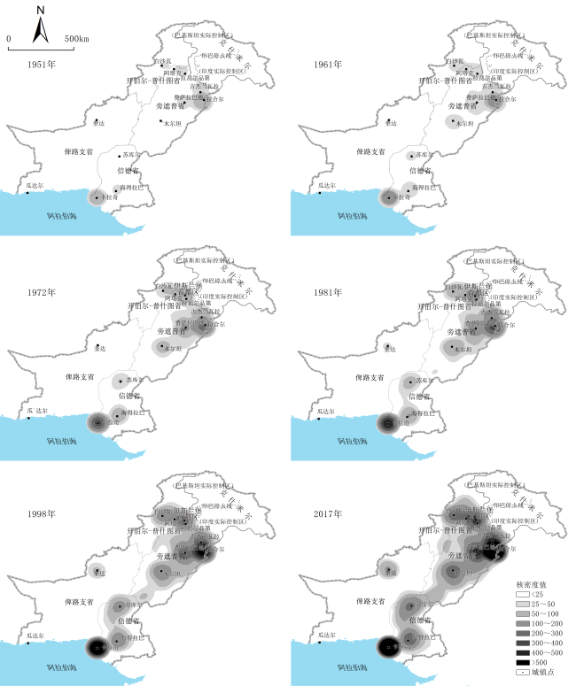
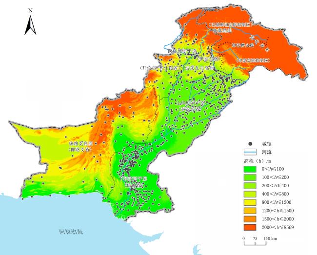
基于人口普查数据、自然环境、经济产业及交通路网等公开数据,运用城镇体系金字塔、城镇规模基尼系数以及核密度分析等方法,对巴基斯坦城镇体系特征及其影响因素进行分析,发现:1)规模结构方面,城镇规模分布较集中,表现为“大城市化”与“小城市化”并重的特征,中间级别城市发展滞后,城镇人口金字塔大致呈现沙漏形态;空间结构方面,整体呈现分异与整合共存的局面,一方面形成东密西疏的城镇密度格局以及各具特色的省级城镇体系,另一方面东南—西北地区城镇空间结构呈现整合趋势,沿东南—西北形成卡拉奇—拉合尔—伊斯兰堡及拉瓦尔品第都市区—白沙瓦“7”型城镇发展轴线;职能结构方面,形成3个全国性中心,2个地区性中心和多个重要工业、交通节点城市。2)城镇体系在内生因素和外生因素交织影响下形成。内生因素方面,自然环境的差异是形成东密西疏城镇空间格局的基础条件,经济产业因素决定城镇体系的基本格局;地形与交通的共同作用改变城镇间的时空距离,造成东西部城镇体系的差异;各省相对独立的社会因素和行政因素造成各省城镇体系的分异。这个过程受国际投资与贸易、地缘政治和中巴经济走廊等外生因素的间接影响。3)中巴经济走廊将促进“7”型城镇发展轴转变为“两纵三横”城镇发展轴体系。
李奇 , 董晔 , 刘云刚 . 巴基斯坦城镇体系特征及其影响因素[J]. 热带地理, 2021 , 41(2) : 290 -302 . DOI: 10.13284/j.cnki.rddl.003330
Pakistan is a influential country in South Asia and an important fulcrum of "The Belt and Road Initiative." The study of its urban system can promote the understanding of Pakistan and provide references for related cooperation. This paper conducts a more comprehensive empirical analysis of the scale structure, spatial structure, and functional structure characteristics of the urban system, based on existing research and on the census data, natural environment, economic industry, and traffic network and other public data. It uses the analysis methods of the urban system pyramid, Gini coefficient of urban scale and nuclear density analysis, and analyzes the endogenous and exogenous factors of the urban system. The results were as follows: 1) First, regarding scale structure, the overall distribution of the urban scale is relatively concentrated, showing characteristics of both "large urbanization" and "small urbanization." The development of intermediate-level cities is delayed, and the urban population pyramid is roughly shaped as an hourglass. Regarding spatial structure, the urban system of Pakistan embodies the coexistence of differentiation and integration, forming different urban density patterns in the East and the West and a provincial urban system with its own characteristics. However, the spatial structure of towns in the southeast-northwest region shows an integration trend. The eastern region gradually formed the urban agglomeration core areas of Karachi and Lahore, and the urban agglomeration areas of the Islamabad-Rawalpindi metropolitan area, Peshawar, Multan, Sukkur, and Hyderabad, with a "seven"-axis distribution in the southeast-northwest. Regarding the functional structure, there are three national centers, two regional centers, and some important industrial and transportation node cities. 2) The urban system is formed under the influence of endogenous and exogenous factors. Regarding endogenous factors, natural environment factors constitute the basis of urban system evolution; the intensity of the economic industry and spatial agglomeration determine the basic pattern of the urban system. The joint effect of terrain and traffic transforms the space-time distance, resulting in the difference of urban systems between the East and the West. The relatively independent social and administrative factors of each province cause the differentiation of the urban systems in each province. This process is indirectly affected by exogenous factors such as international investment and trade, geopolitics, and the China-Pakistan Economic Corridor. 3) The China-Pakistan Economic Corridor will strengthen the motivational force of urbanization in Pakistan, promote the transformation of the "seven" urban development axis into the "two vertical and three horizontal" urban development axis system, and promote the development of western cities. Suggestions for the overall policy of Pakistan's urban system include: (1)promoting the industrialization process, strengthening the power of urbanization, and promoting the development of cities at all levels, especially the intermediate level cities. (2) Further, it proposes strengthening integration development with the world market, promoting the development of cities in the southern coastal areas and the transportation links with inland cities, as well as the development of cities along the line. (3) Finally, it suggests reducing the administrative and social system barriers between provinces, reducing the distance and division of factor flow, and accelerating the process of urban system integration.
表1 巴基斯坦主要城市职能Table 1 Functions of major city in Pakistan |
| 主要城市 | 行政职能 | 交通职能 | 工矿业职能 | 现代服务业职能 | GaWC 2018世界城市级别 | 职能分类 |
|---|---|---|---|---|---|---|
| 卡拉奇 | 省级行政中心 | 航空、港口中心、 铁路重要节点 | 工业中心城市 | 贸易、金融业中心城市 | Beta | 全国性中心城市 |
| 拉合尔 | 省级行政中心 | 航空中心 铁路枢纽 | 工业中心城市 | 科教文化中心、金融业 重要城市 | Gamma+ | 全国性中心城市 |
| 伊斯兰堡-拉瓦尔品第都市区 | 首都 | 航空中心 | 新兴产业城市 | 金融业重要城市 | Gamma | 全国性中心城市 |
| 白沙瓦 | 省级行政中心 | 铁路重要节点 | — | — | — | 地区性中心城市 |
| 奎达 | 省级行政中心 | 铁路枢纽 | — | — | — | 地区性中心城市 |
| 费萨拉巴德 | — | — | 重要工业城市 | — | — | 重要工业城市 |
| 古杰兰瓦拉 | — | — | 重要工业城市 | — | — | 重要工业城市 |
| 海得拉巴 | — | 铁路枢纽 | 重要工业城市 | — | — | 重要工业城市 |
| 木尔坦 | — | 铁路枢纽 | 重要工业城市 | — | — | 重要工业城市 |
| 阿塔克 | — | 铁路枢纽 | — | — | — | 重要交通节点城市 |
| 苏库尔 | — | 铁路枢纽 | — | — | — | 重要交通节点城市 |
| 瓜达尔 | — | 港口城市 | — | — | — | 重要交通节点城市 |
|
图5 巴基斯坦地形、河流与城镇分布Fig.5 Distribution of topography, rivers and cities in Pakistan注:高程数据来源于SRTM网站(http://srtm.csi.cgiar.org/srtmdata/)。 |

1 面积未含克什米尔地区(巴基斯坦实际控制区),下文简称“克什米尔地区”。
2 注:1998、2017年人口普查数据来源于巴基斯坦统计局网站(https://www.pbs.gov.pk/content/population-census);其余年份人口普查数据来源于DSpace Repository网站(http://111.68.102.42:8080/xmlui/handle/123456789/14509)。
3 注:经济调查数据来源于Iris Punjab网站(http://www.irispunjab.gov.pk/ViewStatisticalReports.aspx?Pid=9);统计年鉴数据来源于巴基斯坦统计局网站(https://www.pbs.gov.pk/search/node/Pakistan%20Statistical%20Year%20Book);世界银行数据库网站(https://data.worldbank.org.cn/)。
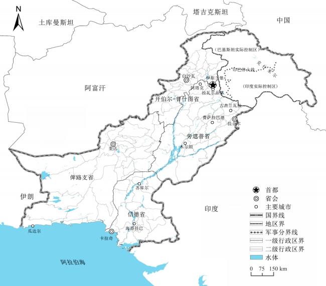
4 注:伊斯兰堡与拉瓦尔品第已经连绵发展,在职能结构、空间结构分析中将两者合称为伊斯兰堡-拉瓦尔品第都市区。
5 钱纳里标准法是广泛应用的用于评价国家经济发展水平与城镇化、工业化水平关系的方法(钱纳里 等,1988;孔凡文 等,2006)。
|
亚瑟·敏赛特,曹康,刘梦琳. 2018. 中小城市是非洲可持续发展成败的关键.国际城市规划,33(5):1-28.
|
|
|
|
|
|
鲍超,陈小杰.2014.中国城市体系的空间格局研究评述与展望.地理科学进展,33(10):1300-1311.
Bao Chao and Chen Xiaojie.2014.Review and Prospect of Research on the Spatial Pattern of China's Urban System.Progress in Geography, 33(10): 1300-1311.
|
|
陈春林,陈才.2013.吉林省城镇体系空间发展格局研究.世界地理研究,22(2):79-87.
Chen Chunlin and Chen Cai.2013.Research on Urban System Spatial Development Pattern in Jilin Province.World Regional Studies, 22(2): 79-87.
|
|
钱纳里 H,赛尓昆 M.1988.发展的型式(1950—1970).北京:经济科学出版社.[Chenery Hollis and Syrquin Moises . 1988. Patterns of Development (1950-1970). Beijing: Economic Science Press.]
|
|
程开明,庄燕杰.2013.中国中部地区城市体系规模分布及演进机制探析.地理科学,33(12):1421-1427.
Cheng Kaiming and Zhuang Yanjie.2013.Size Distribution of Cities and Evolution Mechanism of Urban System in Middle Area of China.Scientia Geographica Sinica, 33(12): 1421-1427.
|
|
科恩 S B.2011.地缘政治学—国际关系的地理学.上海:上海社会科学院出版社.[Cohen S B . 2011. Geopolitics: The Geography of International Relations.Shanghai: Shanghai Academy of Social Sciences Press.]
|
|
杜德斌,马亚华.2015.“一带一路”:中华民族复兴的地缘大战略.地理研究,34(6):1005-1014.
|
|
杜凤姣,宁越敏.2015.拉美地区的城市化、城市问题及治理经验.国际城市规划,30(S1):1-6.
Du Fengjiao and Ning Yuemin.2015.The Urbanization, Urban Problems and Governance Experience of Latin America.Urban Planning International, 30(S1): 1-6.
|
|
冯传禄.2017.“一带一路”视野下南亚地缘政治格局及地区形势发展观察.南亚研究,(3): 1-32,150-151.
|
|
弗林特 C,泰勒 P J.2016.政治地理学:世界-经济、民族-国家与地方.北京:商务印书馆.[Flint C and Taylor P J . 2016. Political Geography: World-Economic, Nation-State and Locality.Beijing: The Commercial Press.]
|
|
顾朝林,于涛方,李玉鸣,等 . 2008.中国城市化:格局·过程·机理. 北京:科学出版社.
|
|
Karachi Master Plan 2020 Project Team. 2007. Karachi Master Plan 2020. Karachi: City District Government Karachi.
|
|
孔凡文,许世卫.2006.我国城镇化与工业化发展关系分析与判断.调研世界,(7):45-47.
Kong Fanwen and Xu Shiwei.2006.Analysis and Judgment of the Relationship between Urbanization and Industrialization Development in China.The World of Survey and Research, (7): 45-47.
|
|
雷诚,范凌云.2010.国外沿海开发对中国滨海地区发展的启示.国际城市规划,25(1):107-111.
Lei Cheng and Fan Lingyun.2010.Study on Coastal Region Development and Its Enlightenment.Urban Planning International, 25(1): 107-111.
|
|
梁振民.2018.中巴经济走廊建设:意义、进展与路径研究.亚太经济,(5):13-20.
|
|
刘金塘,王红丽,蔡虹.2004.中国人口终身迁移状况分析.人口研究,28(3):16-23.
|
|
马子量,马丁丑.2015.甘肃省城市体系规模结构演变分析.城市问题,(1):14-19.
|
|
|
|
宋利芳.2000.发展中国家城市化进程的特点、问题及其治理.中国人民大学学报,(5):33-38.
|
|
宋家泰,顾朝林.1988.城镇体系规划的理论与方法初探.地理学报,43(2):97-107.
Song Jiatai and Gu Chaolin.1988.Theory and Methodology of Urban System Planning.Acta Geographica Sinica, 43(2): 97-107.
|
|
魏建飞,刘晓阳,丁志伟.2019.中国中部地区城镇体系规模结构演变.地域研究与开发,38(2):66-72.
|
|
世界银行.2009.重塑世界经济地理.北京:清华大学出版社.
|
|
熊琛然,武友德,赵俊巍,范毓婷.2016.印度领衔下的南亚地缘政治特点及其对中国的启示.世界地理研究,25(6):38-47.
|
|
薛东前,姚士谋.2000.我国城市系统的形成和演进机制.人文地理,15(1):35-38.
Xue Dongqian and Yao Shimou.2000.Forming and Evolving Mechanism on Urban System in China.Human Geography, 15(1): 35-38.
|
|
许学强,周一星,宁越敏.2009.城市地理学.第2版.北京:高等教育出版社.[Xu Xueqiang, Zhou Yixing and Ning Yuemin . 2009. Urban Geography.2nd Edition.Beijing: Higher Education Press.]
|
|
阎小培,方远平.2002.全球化时代城镇体系规划理论与模式探新——以广东省阳江市为例.城市规划,26(6):40-45.
Yan Xiaopei and Fang Yuanping.2002.A New Approach on the Urban System Planning Theory and Model in the Era of Globalization: Case Study of Yangjiang.City Planning Review, 26(6): 40-45.
|
|
殷永林.2016.独立以来的巴基斯坦经济发展研究.北京:中国社会科学出版社.
|
|
曾祥裕.2009.巴基斯坦瓜达尔港对国际安全态势的影响.南亚研究季刊,(2):31-36.
|
|
张耀铭.2019.中巴经济走廊建设:成果、风险与对策.西北大学学报(哲学社会科学版),49(4):1-9.
|
|
周强,杨宇,刘毅,翟崑.2018.中国“一带一路”地缘政治研究进展与展望.世界地理研究,27(3):1-10.
|
/
| 〈 |
|
〉 |

