
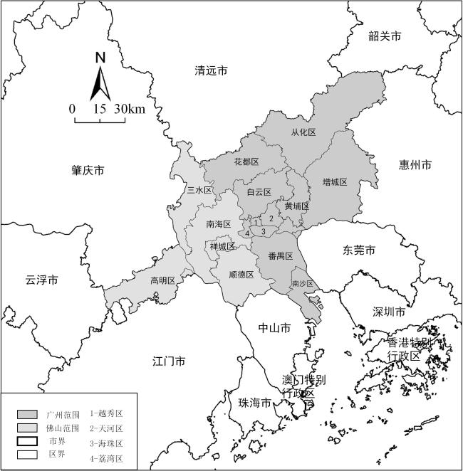
基于多源数据的广佛都市区城市引力结构特征分析
|
占玮(1996—),男,江西九江人,硕士研究生,主要从事城镇与乡村规划研究,(E-mail)zhanwei@m.scnu.edu.cn; |
收稿日期: 2020-11-23
修回日期: 2021-02-02
网络出版日期: 2021-11-16
基金资助
国家自然科学基金项目(41771001)
广州市科技计划项目(201704020136)
Characteristics of the Urban Gravity Structure in the Guangzhou-Foshan Metropolitan Area Based on Multi-Source Data
Received date: 2020-11-23
Revised date: 2021-02-02
Online published: 2021-11-16
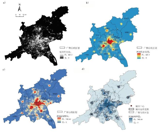
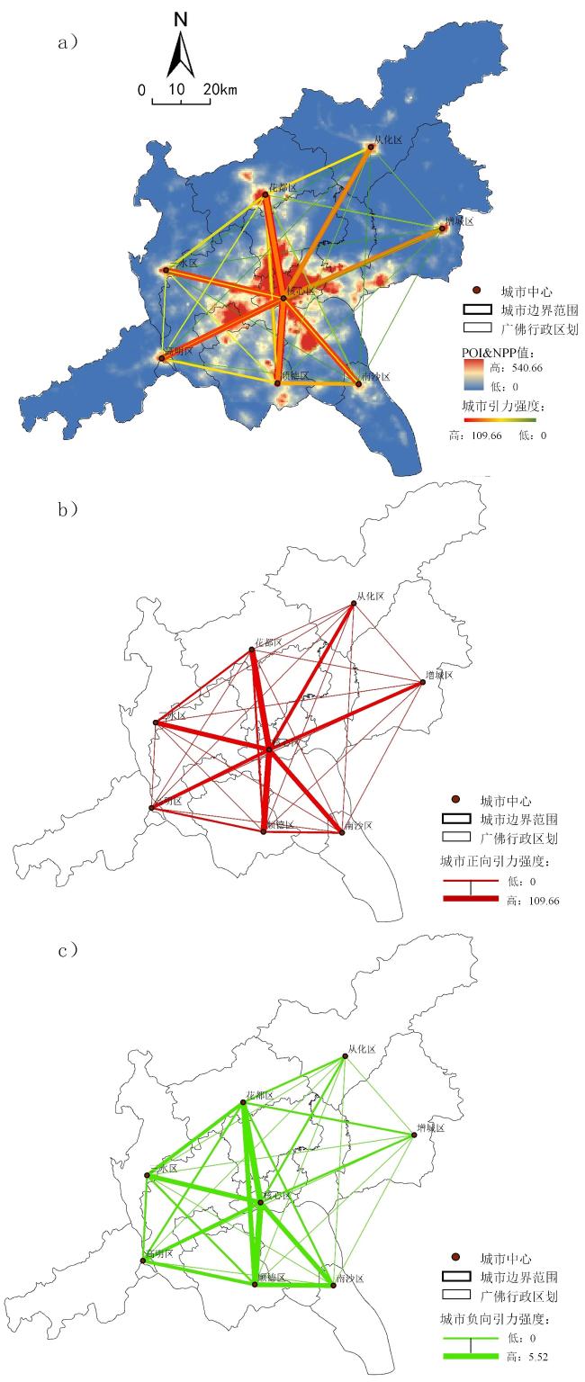
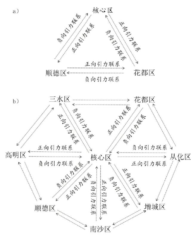
利用夜间灯光遥感数据和POI数据,采用断裂点分析法得出城市实体地域的范围大小。在此基础上引入交通便利系数和相对引力常量修正引力模型,分析广佛都市区内部各个城市实体地域间的引力强度和方向。结果表明:1)广佛都市区形成了以核心区为中心的“7+1”城镇体系结构;2)“七边形”正向城市体系结构围绕核心区域生成,“六边形”负向城市体系结构围绕西南区域生成,“西强东弱”格局明显;3)城市三角结构是广佛城市引力结构的基本单元,发展较好的城市组团为“核心区—顺德—南沙”“核心区—顺德—高明”“核心区—三水—花都”“核心区—花都—从化”,而“核心区—增城—南沙”和“核心区—高明—三水”组团则发展动能不足;4)广佛都市区引力势能大小及结构稳定与城市经济职能强度正相关。
占玮 , 陈朝隆 , 孙武 , 班鹏飞 . 基于多源数据的广佛都市区城市引力结构特征分析[J]. 热带地理, 2021 , 41(6) : 1292 -1302 . DOI: 10.13284/j.cnki.rddl.003401
As the endogenous driving force of regional development, the development of urban entities in metropolitan areas has a great influence on the development of the metropolitan areas, while the interactions between the urban entities' systems directly affect the metropolitan areas' development. Studying the relationship between urban entities in metropolitan areas and the basic development law of the structure between urban centers can provide some reference for the planning, development, and construction management of the urban centers and their surrounding areas in the metropolitan areas. Although the core entity territory of Guangzhou-Foshan has been contiguous, its development connection with the peripheral urban territories remains the focus of research. In the context of the synergistic development of the Bay Area, exploring the characteristic relationships between the urban territories in the Bay Area hinterland can provide a positive response to the sustainable development of the Bay Area cities. This study constructs a POI & NPP composite index by a mathematical mean method to determine the POI & NPP composite value and the number of urban centers; Based on the feature that the integrated data will produce abrupt changes at the boundary, the city's boundary extent is then analyzed using the fracture point analysis method. We then analyze the strength and direction of the gravitational force between the urban entities within the Guangzhou-Foshan metropolitan area by adding the modified gravitational force model based on the divided urban-entity territory and the POI & NPP composite index within the scope. The results show the following: (1) A "7+1" urban system structure centered on the core area is formed in the Guangzhou-Foshan metropolitan area. (2) A "heptagonal" positive urban system structure is generated around the core area and a "hexagonal." (3) The urban triangle structure is the basic unit of the Guangzhou-Foshan urban gravitational structure, while the better-developed urban clusters are "Core-Shunde-Nansha," "Core-Shunde–Gaoming," "Core-Sanshui–Huadu," "Core-Huadu-Conghua," "Core-Zengcheng-Nansha," and "Core." (4) The size and structural stability of the gravitational potential of the Guangzhou-Foshan metropolitan area are positively related to the intensity of the urban economic functions.
图3 广佛都市区城市中心结构联系(a. 城市结构联系;b. 正向联系;c. 负向联系)Fig.3 The structural connection of urban centers in Guangzhou-Foshan Metropolitan Area(a. Urban structural linkage; b. positive linkage; c. negative linkage) |
表1 2018年广佛都市区“7+1”城市中心的引力与城市引力势能Table 1 The gravitational force and urban gravitational potential of the "7+1" urban center in the Guangzhou-Foshan metropolitan area in 2018 |
| 分区 | 核心区 | 增城区 | 顺德区 | 三水区 | 南沙区 | 花都区 | 高明区 | 从化区 | |
|---|---|---|---|---|---|---|---|---|---|
| 城市中心引力 | 核心区 | — | 5.973 | 109.665 | 14.395 | 17.515 | 80.604 | 10.630 | 4.696 |
| 增城区 | 0.097 | — | 0.033 | 0.007 | 0.020 | 0.047 | 0.006 | 0.089 | |
| 顺德区 | 5.919 | 0.161 | — | 0.376 | 1.566 | 0.359 | 0.638 | 0.102 | |
| 三水区 | 0.272 | 0.216 | 0.087 | — | 0.015 | 0.127 | 0.240 | 0.022 | |
| 南沙区 | 0.331 | 0.062 | 0.364 | 0.045 | — | 0.050 | 0.053 | 0.025 | |
| 花都区 | 5.758 | 0.279 | 1.109 | 0.669 | 0.261 | — | 0.264 | 0.515 | |
| 高明区 | 0.182 | 0.017 | 0.139 | 0.080 | 0.018 | 0.0467 | — | 0.013 | |
| 从化区 | 0.070 | 0.030 | 0.020 | 0.007 | 0.008 | 0.081 | 0.004 | — | |
| 城市引力势能 | 243.478 | 0.299 | 9.121 | 0.979 | 0.933 | 8.855 | 0.495 | 0.220 | |
图4 城市结构构成单位示意(a)、广佛都市区城市引力结构模型(b)Fig.4 Illustration of urban structure component unit (a), model of urban gravitational structure of Guangzhou-Foshan metropolitan area (b) |
表2 广佛都市区城市三角组团引力势能联系Table 2 Contact Form of Gravitational Potential Energy of Guangzhou-Foshan Urban Triangle Group |
| 城市三角组团 | 正向引力循环 | 负向引力循环 |
|---|---|---|
| 核心区—花都—从化组团 | 85.325 | 5.909 |
| 核心区—从化—增城组团 | 10.758 | 0.197 |
| 核心区—增城—南沙组团 | 23.55 | 0.448 |
| 核心区—南沙—顺德组团 | 128.746 | 6.614 |
| 核心区—顺德—高明组团 | 120.933 | 6.24 |
| 核心区—高明—三水组团 | 25.265 | 0.534 |
| 核心区—三水—花都组团 | 95.668 | 6.157 |
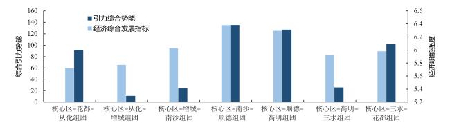
图5 2018年广佛都市区城市三角组团与城市经济职能强度对比Fig.5 Comparison of the intensity of urban triangle clusters and urban economic functions in the Guangzhou-Foshan Metropolitan Area in 2018 |
表3 2018年广佛都市区“7+1”城市各项社会经济指标与城市经济职能强度Table 3 Guangzhou-Foshan Metropolitan Area "7+1" city various socio-economic indicators and central function intensity in 2018 |
| 分区 | 地区生产总值/亿元 | 人均GDP/万元 | 公共财政收入均值/亿元 | 固定投资资产/亿元 | 消费品零售总额/亿元 | 城市经济职能强度 |
|---|---|---|---|---|---|---|
| 核心区 | 23 165.92 | 155.16 | 894.1 | 5 854.02 | 9 963.87 | 5.220 |
| 增城区 | 1 124.11 | 9.30 | 95.16 | 1 005.48 | 370.98 | 0.415 |
| 顺德区 | 3 163.93 | 11.90 | 235.78 | 1 101.98 | 971.89 | 0.771 |
| 三水区 | 1 227.95 | 18.57 | 62.44 | 799.02 | 240.68 | 0.396 |
| 南沙区 | 1 458.41 | 19.75 | 75.19 | 588.18 | 208.77 | 0.392 |
| 花都区 | 1 358.37 | 12.53 | 84.82 | 413.7 | 524.6 | 0.365 |
| 高明区 | 879.48 | 19.92 | 40.4 | 490.99 | 139.47 | 0.304 |
| 从化区 | 416.68 | 6.46 | 28.87 | 188.86 | 123.45 | 0.136 |

1 https://ngdc.noaa.gov/eog/
2 https://lbs.amap.com
3 https://www.openstreetmap.org/
4 https://data.gz.gov.cn/
|
Aguilar A G and Hernandez J. 2016. Metropolitan Change and Uneven Distribution of Urban Sub-Centres in Mexico City, 1989-2009. Bulletin of Latin American Research, 35(2): 191-209.
|
|
班鹏飞,李刚,袁奇峰,李晓建. 2018. 区域视角下大城市的功能疏解及广佛都市区的实证. 规划师,34(9):18-23. [Ban Pengfei, Li Gang, Yuan Qifeng and Li Xiaojian. 2018. Functional Decentralization of Large Cities in A Regional Perspective and Empirical Evidence of the Guangzhou-Foshan Metropolitan Area. Planner, 34(9): 18-23. ]
|
|
Christaller W. 1933. 德国南部中心地原理. 常正义,王兴中. 译. 北京:商务印书馆. [Christaller W. 1933. The Principle of the Southern German Heartland. Chang Zhengyi and Wang Xingzhong. Trans.. Beijing: The Commercial Press. ]
|
|
Coffey W J and Shearmur R G. 1997. The Growth and Location of High Order Services in the Canadian Urban System, 1971-1991. Professional Geographer, 49(4): 404-418.
|
|
Converse P D. 1949. New Laws of Retail Gravitation. Journal of Marketing, 14(3): 379-384.
|
|
陈颖彪,郑子豪,吴志峰,千庆兰. 2019. 夜间灯光遥感数据应用综述和展望. 地理科学进展,38(2):205-223. [Chen Yingbiao, Zheng Zihao, Wu Zhifeng and Qian Qinglan. 2019. A Review and Outlook on the Application of Remote Sensing Data for Nighttime Lighting. Advances in Geoscience, 38(2): 205-223. ]
|
|
陈佑启. 1996. 试论城乡交错带及其特征与功能. 经济地理,16(3):27-31. [Chen Youqi. 1996. Experimental Discussion on Urban-Rural Intersection Zone and Its Characteristics and Functions. Economic Geography, 16(3): 27-31. ]
|
|
池娇,焦利民,董婷,谷岩岩,马雅兰. 2016. 基于POI数据的城市功能区定量识别及其可视化. 测绘地理信息,41(2):68-73. [Chi Jiao, Jiao Limin, Dong Ting, Gu Yanyan and Ma Yalan. 2016. Quantitative Identification of Urban Functional Areas Based on POI Data and Its Visualization. Mapping and Geographic Information, 41(2): 68-73. ]
|
|
方斌,张宪哲,杨柳. 2017. 基于POI数据的城市边界变化提取研究——以山西运城市城区为例. 现代测绘,40(5):20-22. [Fang Bin, Zhang Xianzhe and Yang Liu. 2017. Research on Extraction of Urban Boundary Changes Based on POI Data—An Example of Urban Area in Yuncheng City, Shanxi. Modern Surveying and Mapping, 40(5): 20-22. ]
|
|
方远平,彭婷,陆莲芯,毕斗斗,陈再齐. 2019. 粤港澳大湾区城市职能演变特征与影响因素. 热带地理,39(5):647-660. [Fang Yuanping, Peng Ting, Lu Lianxin, Bi Doudou and Chen Zaiqi. 2019. Characteristics and Influencing Factors of the Evolution of Urban Functions in the Guangdong-Hong Kong-Macao Greater Bay Area. Tropical Geography, 39(5): 647-660. ]
|
|
Green N. 2007. Functional Polycentricity: A Formal Definition in Terms of Social Network Analysis. Urban Studies, 44(11): 2077-2103.
|
|
Gordon P and Lee Bumsoo. 2015. "Spatial Structure and Travel: Trends in Commuting and Non-Commuting Travels in US Metropolitan Areas." In: Hickman R, Givoni M, Bonilla D and Banister D Edward Elgar. Handbook on Transport and Development. Edward Elgar Publishing.
|
|
高爽,王少剑,王泽宏. 2019. 粤港澳大湾区知识网络空间结构演化特征与影响机制. 热带地理,39(5):678-688. [Gao Shuang, Wang Shaojian and Wang Zehong. 2019. Spatial Structure Evolution Characteristics and Influence Mechanisms of Knowledge Networks in Guangdong-Hong Kong-Macao Greater Bay Area. Tropical Geography, 39(5): 678-688. ]
|
|
顾朝林,庞海峰. 2008. 基于重力模型的中国城市体系空间联系与层域划分. 地理研究,27(1):1-12. [ Gu Chaolin and Pang Haifeng. 2008. Spatial Linkage and Hierarchical Domain Classification of Chinese Urban Aystem Based on Gravity Model. Geography Research, (1): 1-12. ]
|
|
Han R, Cao H and Liu Z . 2018. Studying the Urban Hierarchical Pattern and Spatial Structure of China Using a Synthesized Gravity Model. China Science: Earth Science, 61(12): 1818-1831.
|
|
洪世键,黄晓芬. 2007. 大都市区概念及其界定问题探讨. 国际城市规划,28(5):50-57. [Hong Shijian and Huang Xiaofen. 2007. Exploring the Concept of Metropolitan Area and Its Definition. International Urban Planning, 28(5): 50-57. ]
|
|
Henderson J V. 1974. Optimum City Size: The External Diseconomy Question. Journal of Political Economy, 82: (2): 373-388.
|
|
Kanemoto Y. 1980. Theories of Urban Externalities. Germany: University Library of Munich.
|
|
Lou G, Chen Q, He K, Zhou Y and Shi Z. 2019. Using Nighttime Light Data and POI Big Data to Detect the Urban Centers of Hangzhou. Remote Sensing, 11(15): 1821-1821.
|
|
Li L, Sun Z and Long X. 2018. An Empirical Analysis of Night-Time Light Data Based on the Gravity Model. Applied Economics, 51: 1-18.
|
|
刘荷,王健. 2014. 基于轴辐理论的区域物流网络构建及实证研究. 经济地理,34(2):108-113. [He Liu and Jian Wang . 2014. Construction and Empirical Study of Regional Logistics Network Based on Axis and Spoke Theory. Economic Geography, 34(2): 108-113. ]
|
|
刘锐,胡伟平,王红亮,吴驰,何劲. 2011. 基于核密度估计的广佛都市区路网演变分析. 地理科学,31(1):81-86. [Liu Rui, Hu Weiping, Wang Hongliang, Wu Chi and He Jin. 2011. Analysis of Road Network Evolution in Guangfo Metropolitan Area Based on Kernel Density Estimation. Geoscience, 31(1): 81-86. ]
|
|
厉飞,闫庆武,邹雅婧,刘保丽. 2021. 利用夜间灯光POI的城市建成区提取精度研究——以珞珈一号01星和NPP/VIIRS夜间灯光影像为例. 武汉大学学报(信息科学版),46(6):825-835. [Li Fei, Yan Qingwu, Zou Yajing and Liu Baoli. 2021. Research on the Accuracy of Urban Built-up Area Extraction using Nighttime Light POI—Example of Nighttime Light Images with Luojia-01 Star and NPP/VIIRS. Journal of Wuhan University (Information Science Edition), 46(6): 825-835. ]
|
|
Martin J Burger, Bert van der Knaap and Ronald S Wall. 2013. Polycentricity and the Multiplexity of Urban Networks. European Planning Studies, 22(4): 816-840.
|
|
钱春蕾,叶菁,陆潮. 2015. 基于改进城市引力模型的武汉城市圈引力格局划分研究. 地理科学进展,34(2):237-245. [Qian Chunlei, Ye Jing and Lu Chao. 2015. Research on Gravitational Pattern Division of Wuhan City Circle Based on Improved City Gravitational Model. Advances in Geographical Sciences, 34(2): 237-245. ]
|
|
舒松,余柏蒗,吴健平,刘红星. 2011. 基于夜间灯光数据的城市建成区提取方法评价与应用. 遥感技术与应用,26(2):169-176. [Shu Song, Yu Bolang, Wu Jianping and Liu Hongxing. 2011. Evaluation and Application of Extraction Methods for Urban Built-up Areas Based on Nighttime Lighting Data. Remote Sensing Technology and Applications, 26(2): 169-176. ]
|
|
王林申. 2017. “流”与“形”:大都市区外围城市中心的生成机理与规划控制. 天津:天津大学. [Wang Linshen. 2017. "Flow" and "Shape": The Generation Mechanism and Planning Control of Peripheral Urban Centers in Metropolitan Areas. Tianjin: Tianjin University. ]
|
|
王兴平. 2002. 都市区化:中国城市化的新阶段. 城市规划汇刊,(4):56-59,80. [Wang Xingping. 2002. Urbanization: A New Stage of Urbanization in China. Journal of Urban Planning, (4): 56-59, 80. ]
|
|
吴燕,李红波. 2020. 大都市城乡融合区空间演进及内在关联性测度——基于武汉市夜间灯光数据. 地理科学进展,39(1):13-23. [Wu Yan and Li Hongbo. 2020. Spatial Evolution and Intrinsic Correlation Measurement of Urban-Rural Integration Area in Metropolis—Based on Nighttime Lighting Data of Wuhan city. Advances in Geographical Sciences, 39(1): 13-23. ]
|
|
薛冰,肖骁,李京忠,姜璐,谢潇. 2018. 基于POI大数据的城市零售业空间热点分析——以辽宁省沈阳市为例. 经济地理,38(5):36-43. [Xue Bing, Xiao Xiao, Li Jingzhong, Jiang Lu and Xie Xiao. 2018. Spatial Hotspot Analysis of Urban Retail Based on POI Big Data—Shenyang City, Liaoning Province as An Example. Economic Geography, 38(5): 36-43. ]
|
|
许芸鹭,雷国平. 2018. 辽中南城市群空间联系测度. 城市问题,(11):65-74. [Xu Yunlu and Lei Guoping. 2018. Measurement of Spatial Linkages in the South-Central Liaoning Urban Agglomeration. Urban Issues, (11): 65-74. ]
|
|
许泽宁,高晓路. 2016. 基于电子地图兴趣点的城市建成区边界识别方法. 地理学报,71(6):928-939. [Xu Zening and Gao Xiaolu. 2016. A Method of Urban Built-up Area Boundary Identification Based on Electronic Map Interest Points. Journal of Geography, 71(6): 928-939. ]
|
|
Yang Yuli, Ma Mingguo, Tan Chao and Li Wangping. 2017. Spatial Recognition of the Urban-Rural Fringe of Beijing Using DMSP/OLS Nighttime Light Data. Remote Sensing, 9(11): 1141.
|
|
杨眉,王世新,周艺,王丽涛. 2011. DMSP/OLS夜间灯光数据应用研究综述. 遥感技术与应用,26(1):45-51. [Yang Mei, Wang Shixin, Zhou Yi and Wang Litao. 2011. A Review of DMSP/OLS Nighttime Lighting Data Application Research. Remote Sensing Technology and Applications, 26(1): 45-51. ]
|
|
于丙辰,刘玉轩,陈刚. 2018. 基于夜光遥感与POI数据空间耦合关系的南海港口城市空间结构研究. 地球信息科学学报,20(6):854-861. [Yu Bingchen, Liu Yuxuan and Chen Gang. 2018. Study on the Spatial Structure of Port Cities in the South China Sea Based on the Spatial Coupling Relationship Between Luminous Remote Sensing and POI Data. Journal of Geoinformation Science, 20(6): 854-861. ]
|
|
叶强,张俪璇,彭鹏,黄军林. 2017. 基于百度迁徙数据的长江中游城市群网络特征研究. 经济地理,37(8):53-59. [Ye Qiang, Zhang Lixuan, Peng Peng and Huang Junlin. 2017. A Study on Network Characteristics of Urban Clusters in The Middle Reaches of Yangtze River Based on Baidu Migration Data. Economic Geography, 37(8): 53-59. ]
|
|
Zhou Yuyu, Smith Steven J, Elvidge Christopher D, Zhao K and Imhoff M. 2014. A Cluster-Based Method to Map Urban Area from DMSP/OLS Nightlights. Remote Sensing of Environment, 147: 173-185.
|
/
| 〈 |
|
〉 |