
中南半岛农田/森林活跃火与人口密度的相关性动态特征
|
刘颖(1997—),女,甘肃张掖人,硕士,主要从事资源地理与国土遥感监测研究,(E-mail)ly764860138@163.com; |
收稿日期: 2022-01-19
修回日期: 2022-04-14
网络出版日期: 2023-03-31
基金资助
国家自然科学基金项目(41971242)
中国科学院青年创新促进会会员人才专项(CAS2020055)
Dynamic Characteristics of Correlation between Cropland and Forest Active Fires and Population Density in Mainland Southeast Asia
Received date: 2022-01-19
Revised date: 2022-04-14
Online published: 2023-03-31
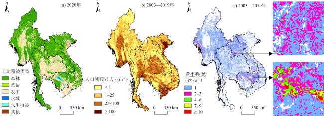
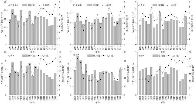
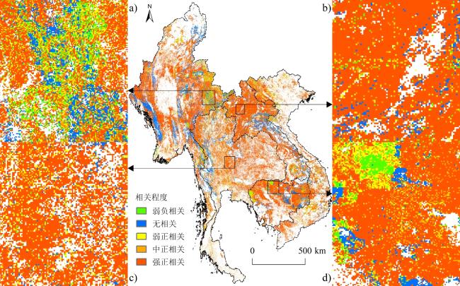
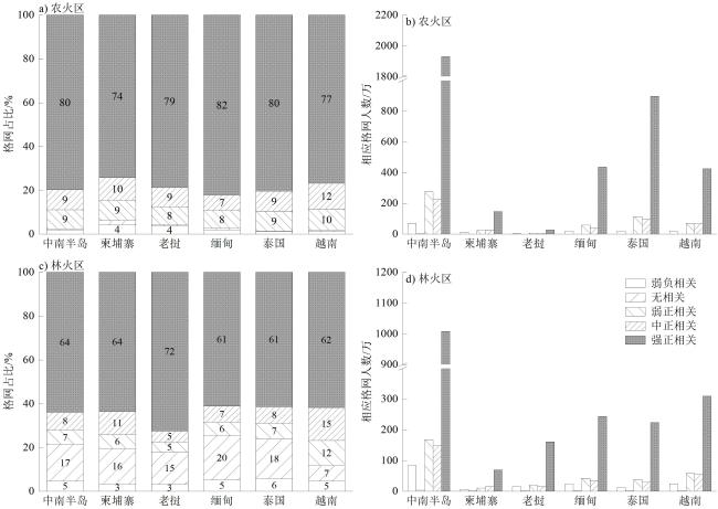
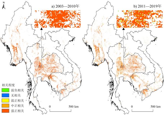
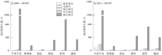
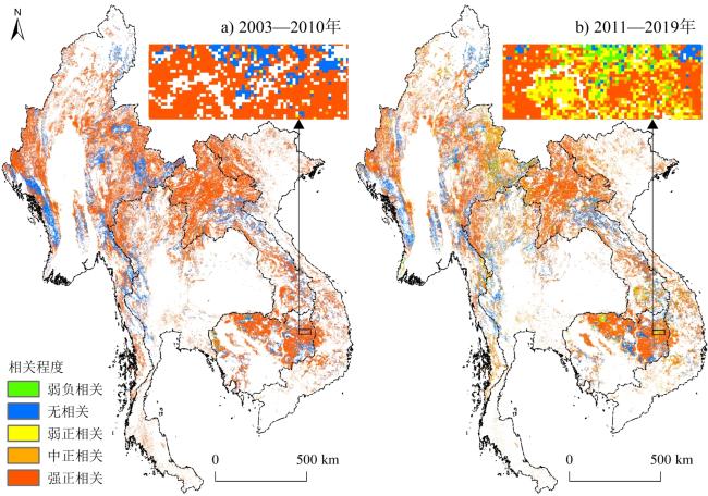
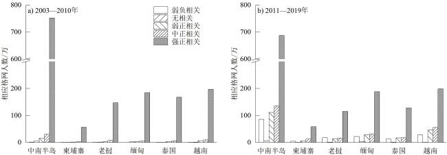
人类活动是活跃火发生发展的重要诱因,明确人-火关系对火情规律揭示、碳排放估算与公共健康管理等具有重要意义。利用2003—2019年MODIS Collection 6(MODIS C6)活跃火和LandScan人口密度数据产品,基于GIS公里渔网、双变量空间相关性等分析方法,定量揭示了中南半岛农田/森林活跃火发生强度与人口分布的时空关联特征及其动态发展特征。结果表明:1)中南半岛约八成“有火区”的活跃火发生强度与人口密度存在空间正相关,且中等正相关及以上(r >0.4)格网近占3/4,主要分布在泰国中/东部、缅甸东/西部、老挝北部和柬埔寨东北部等。2)中南半岛年内“农火区”人口多于“林火区”,且前者超九成格网、后者近3/4格网与人口分布存在空间正相关性。3)“农火区”强正相关格网主要分布在缅甸南部、泰国中/东部等人口密度为25~100人/km2的区域,而“林火区”相应格网多分布于缅甸东/西部、老挝北部、柬埔寨东北部等人口密度<25人/km2的区域。4)受人口增长影响,2003—2010年农火和林火发生强度与人口分布相关性虽均明显高于2011—2019年,但后期“农火区”与“林火区”年均人口均有明显增幅。
刘颖 , 李鹏 , 尹旭 , 肖池伟 , 施冬 . 中南半岛农田/森林活跃火与人口密度的相关性动态特征[J]. 热带地理, 2023 , 43(3) : 554 -566 . DOI: 10.13284/j.cnki.rddl.003565
Anthropogenic activities including slashing and burning (or swidden agriculture), illegal logging, and agricultural residue burning, are important drivers and driving mechanisms for the occurrence and development of global active fires especially in the tropics. In the past, limited by the access to the global datasets of gridded population density and consistent active fires, the research on the correlation between the occurrence and development of active fires and human activities was relatively insufficient. It is of great significance to clarify the relationship between human and fire for the sake of revealing the nature of fire regime, estimating carbon emissions and public health management. With Moderate Resolution Imaging Spectroradiometer (MODIS) Collection 6 (C6) active fire products provided by the Fire Information for Resource Management System (FIRMS) and LandScan Global Population Database (e.g., population density) developed by the Department of Energy's Oak Ridge National Laboratory (ORNL) during 2003-2019, the dynamic characteristics of spatial and temporal correlations between occurrence intensity of agricultural and forest active fires and population distribution in Mainland Southeast Asia were quantitatively revealed through GIS-based fishnet (1km) statistical analysis and bivariate spatial correlation. The results show that: (1) Nearly 80% of the "fire-affected grids" in Mainland Southeast Asia were positively correlated with population distribution during the study period. Grids with medium positive correlation and above (r>0.4) accounted for approximately 75%, mainly distributed in areas with low population density (<25 persons/km2) and covered by forest, including central and eastern Thailand, eastern and western Myanmar, northern Laos and northeastern Cambodia. (2) Cropland "fire-affected grids" in Mainland Southeast Asia during 2003-2019 have more population than forest fire-affected grids. More than 90% of the agricultural fire grids and nearly 3/4 of the counterpart of forest fire were positively correlated with population distribution. (3) The grids of strong positive correlation within agricultural fire area were mainly distributed in areas with population density of 25~100 persons/km2, such as southern Myanmar, and central and eastern Thailand. In contrast, the corresponding grids within forest fire area were mostly seen in areas with population density below 25 persons/km2, which include eastern and western Myanmar, northern Laos, and northeastern Cambodia. (4) The correlation between occurrence intensity of agricultural and forest fires and population distribution during 2003-2010 was significantly higher than that during 2011-2019, while the annual average population increased obviously in cropland and forest fire grids in the second period.
表1 中南半岛及其五国活跃火发生与人口分布不同等级相关性格网占比及相应人口统计Table 1 Proportions of grids under various correlation between active fire occurrence and population density and its corresponding population in Mainland Southeast Asia and its five countries |
| 统计指标 | 相关性 | 中南半岛 | 柬埔寨 | 老挝 | 缅甸 | 泰国 | 越南 |
|---|---|---|---|---|---|---|---|
| 格网 占比/% | 弱负相关 | 3.96 | 3.23 | 3.26 | 4.78 | 3.48 | 4.00 |
| 无相关 | 13.10 | 12.99 | 14.04 | 17.63 | 8.88 | 5.80 | |
| 弱正相关 | 7.17 | 6.35 | 4.73 | 6.51 | 8.30 | 11.22 | |
| 中正相关 | 8.45 | 10.45 | 5.28 | 7.31 | 8.47 | 14.48 | |
| 强正相关 | 67.32 | 66.98 | 72.69 | 63.77 | 70.87 | 64.50 | |
| 总计 | 100 | 100 | 100 | 100 | 100 | 100 | |
| 相应 人口/万 | 弱负相关 | 187 | 22 | 22 | 50 | 40 | 53 |
| 无相关 | 7 | 1 | 1 | 2 | 2 | 1 | |
| 弱正相关 | 550 | 39 | 31 | 118 | 197 | 165 | |
| 中正相关 | 484 | 48 | 24 | 80 | 165 | 167 | |
| 强正相关 | 3 611 | 265 | 229 | 780 | 1 334 | 1 003 | |
| 总计 | 4 839 | 375 | 307 | 1 030 | 1 738 | 1 389 |
表2 中南半岛及其五国农火发生与人口分布不同等级相关性格网占比统计 (%)Table 2 Proportions of grids under various correlation betweenagricultural fire occurrence and population density in Mainland Southeast Asia and its five countries |
| 地区 | 年份 | 弱负相关 | 无相关 | 弱正相关 | 中正相关 | 强正相关 | 总计 |
|---|---|---|---|---|---|---|---|
| 中南半岛 | 2003—2010 | 0.27 | 1.04 | 1.44 | 2.36 | 94.89 | 100 |
| 2011—2019 | 2.51 | 0.72 | 7.09 | 9.55 | 80.13 | 100 | |
| 柬埔寨 | 2003—2010 | 0.01 | 0.33 | 0.55 | 1.48 | 97.63 | 100 |
| 2011—2019 | 3.55 | 2.58 | 6.53 | 11.22 | 76.12 | 100 | |
| 老挝 | 2003—2010 | 0.04 | 0.01 | 2.31 | 7.04 | 90.60 | 100 |
| 2011—2019 | 4.28 | 0.93 | 17.20 | 20.98 | 56.61 | 100 | |
| 缅甸 | 2003—2010 | 0.01 | 0.09 | 0.34 | 1.92 | 97.64 | 100 |
| 2011—2019 | 2.56 | 0.94 | 7.93 | 8.82 | 79.75 | 100 | |
| 泰国 | 2003—2010 | 0.03 | 0.01 | 0.50 | 1.12 | 98.34 | 100 |
| 2011—2019 | 2.29 | 0.21 | 6.49 | 8.07 | 82.94 | 100 | |
| 越南 | 2003—2010 | 0.13 | 0.02 | 1.17 | 2.65 | 96.03 | 100 |
| 2011—2019 | 2.13 | 0.59 | 6.94 | 14.54 | 75.80 | 100 |
表3 中南半岛及其五国林火发生与人口分布不同等级相关性格网占比统计 (%)Table 3 Proportions of grids under various correlation between forest fire occurrence and population density in Mainland Southeast Asia and its five countries |
| 地区 | 年份 | 弱负相关 | 无相关 | 弱正相关 | 中正相关 | 强正相关 | 总计 |
|---|---|---|---|---|---|---|---|
| 中南半岛 | 2003—2010 | 0.11 | 20.45 | 1.12 | 1.72 | 76.60 | 100 |
| 2011—2019 | 4.33 | 18.02 | 5.51 | 6.77 | 65.37 | 100 | |
| 柬埔寨 | 2003—2010 | 0.42 | 18.73 | 2.01 | 2.67 | 76.17 | 100 |
| 2011—2019 | 2.51 | 17.46 | 5.17 | 9.14 | 65.72 | 100 | |
| 老挝 | 2003—2010 | 0.04 | 14.68 | 0.82 | 1.68 | 82.78 | 100 |
| 2011—2019 | 3.87 | 15.62 | 4.82 | 5.74 | 69.95 | 100 | |
| 缅甸 | 2003—2010 | 0.05 | 26.35 | 0.80 | 1.19 | 71.61 | 100 |
| 2011—2019 | 4.78 | 21.06 | 5.70 | 5.73 | 62.73 | 100 | |
| 泰国 | 2003—2010 | 0.17 | 20.35 | 1.71 | 2.50 | 75.27 | 100 |
| 2011—2019 | 6.15 | 22.18 | 5.41 | 5.34 | 60.92 | 100 | |
| 越南 | 2003—2010 | 0.11 | 11.79 | 1.21 | 1.88 | 85.01 | 100 |
| 2011—2019 | 3.73 | 8.13 | 6.67 | 11.36 | 70.11 | 100 |

1 https://firms.modaps.eosdis.nasa.gov/download/
2 https://www.satpalda.com/product/landscan/
3 https://modis.gsfc.nasa.gov/data/dataprod/mod12.php
4 https://data.worldbank.org/
刘 颖:数据收集处理,制图与初稿撰写;
李 鹏:框架确定,全程指导与后期修改;
尹 旭:协助人口密度分析并参与文章修改;
肖池伟:协助活跃火分析并参与文章修改;
施 冬:参与文章指导与后期修改。
|
Andela N, Morton D C, Giglio L, Chen Y, Werf G R, Kasibhatla P S, DeFries R S, Collatz G J, Hantson S, Kloster S, Bachelet D, Forrest M, Lasslop G, Li F, Mangeon S, Melton J R, Yue C, and Randerson J T. 2017. A Human-Driven Decline in Global Burned Area. Science, 356(6345): 1356-1362.
|
|
Baker P J, and Bunyavejchewin S. 2009. Fire Behavior and Fire Effects across the Forest Landscape of Continental Southeast Asia. In: Mark A Cochrane. Tropical Fire Ecology: Climate Change, Land Use, and Ecosystem Dynamics. Berlin: Springer. https://doi.org/10.1007/978-3-540-77381-8_11.
|
|
Benali A, Mota B, Carvalhais N, Oom D, Miller L M, Campagnolo M L, and Pereira J M C. 2017. Bimodal Fire Regimes Unveil a Global-Scale Anthropogenic Fingerprint. Global Ecology and Biogeography, 26(7): 799-811.
|
|
Berna F, Goldberg P, Horwitz L K, Brink J, Holt S, Bamford M, and Chazan Michael. 2012. Microstratigraphic Evidence of in Situ Fire in the Acheulean Strata of Wonderwerk Cave, Northern Cape Province, South Africa. Proceedings of the National Academy of Sciences, 109(20): E1215-E1220.
|
|
Bhaduri B, Bright E, Coleman P, and Urban M L. 2007. LandScan USA: A High-Resolution Geospatial and Temporal Modeling Approach for Population Distribution and Dynamics. GeoJournal, 69(1/2): 103-117.
|
|
Bistinas I, Harrison S P, Prentice I C, and Pereira J M C. 2014. Causal Relationships versus Emergent Patterns in the Global Controls of Fire Frequency. Biogeosciences, 11(18): 5087-5101.
|
|
Bistinas I, Oom D, Sá A C L, Harrison S P, Prentice I C, and Pereira J M C. 2013. Relationships between Human Population Density and Burned Area at Continental and Global Scales. PLoS One, 8(12): e81188.
|
|
柏中强,王卷乐,杨飞. 2013. 人口数据空间化研究综述. 地理科学进展,32(11):1692-1702.
Bai Zhongqiang, Wang Juanle, and Yang Fei. 2013. Research Progress in Spatialization of Population Data. Progress in Geography, 32(11): 1692-1702.
|
|
Calka B, and Bielecka E. 2019. Reliability Analysis of LandScan Gridded Population Data, the Case Study of Poland. International Journal of Geo-Information, 8(5): 222.
|
|
陈军,廖安平,陈晋,彭舒,陈利军,张宏伟. 2017. 全球30m地表覆盖遥感数据产品-Globe Land30. 地理信息世界,24(1):1-8. [Chen Jun, Liao Anping, Chen Jin, Peng Shu, Chen Lijun, and Zhang Hongwei. 2017. 30-Meter Global Land Cover Data Product- Global Land30. Geomatics World, 24(1): 1-8. ]
|
|
Collins K M, Price O F, and Penman T D. 2015. Spatial Patterns of Wildfire Ignitions in South-Eastern Australia. International Journal of Wildland Fire, 24(8): 1098-1108.
|
|
Davies D K, Ilavajhala S, and Wong M M. 2008. Fire Information for Resource Management System: Archiving and Distributing Modis Active Fire Data. IEEE Transactions on Geoscience and Remote Sensing, 47(1): 72-79.
|
|
Friedl M, and Sulla-Menashe D. MCD12Q1 MODIS/Terra+Aqua Land Cover Type Yearly L3 Global 500m SIN Grid V006. https://doi.org/10.5067/MODIS/MCD12Q1.006, 2019/2021-10-13.
|
|
Giglio L, Descloitres J, Justice C O, and Kaufman Y J. 2003. An Enhanced Contextual Fire Detection Algorithm for MODIS. Remote Sensing of Environment, 87(2/3): 273-282.
|
|
Giglio L, Schroeder W, and Justice C O. 2016. The Collection 6 MODIS Active Fire Detection Algorithm and Fire Products. Remote Sensing of Environment, 178: 31-41.
|
|
Hantson S, Lasslop G, Kloster S, and Chuvieco E. 2015. Anthropogenic Effects on Global Mean Fire Size. International Journal of Wildland Fire, 24(5): 89-96.
|
|
Hantson S, Padilla M, Corti D, and Chuvieco E. 2013. Strengths and Weaknesses of MODIS Hotspots to Characterize Global Fire Occurrence. Remote Sensing of Environment, 131: 152-159.
|
|
Justice C O, Giglio L, Korontzi S, Owens J, Morisette J, T Roy D, Descloitres J, Alleaume S, Petitcolin F, and Kaufman Y. 2002. The MODIS Fire Products. Remote Sensing of Environment, 83(1): 244-262.
|
|
Knorr W, Arneth A, and Jiang L. 2016. Demographic Controls of Future Global Fire Risk. Natural Climate Change, 6(8): 781-785.
|
|
Leeuwen T T, Werf G R, Hoffmann A A, Detmers R G, Rücker G, French N H F, Archibald S, Carvalho J A, Cook G D, Groot W J, Hély C, Kasischke E S, Kloster S, McCarty J L, Pettinari M L, Savadogo P, Alvarado E C, Boschetti L, Manuri S, Meyer C P, Siegert F, Trollope L A, and Trollope W S W. 2014. Biomass Burning Fuel Consumption Rates: A Field Measurement Database. Biogeosciences, 11(24): 7305-7329.
|
|
Leyk S, Gaughan A E, Adamo S B, Sherbinin A, Balk D, Freire S, Rose A, Stevens F R, Blankespoor B, Frye C, Comenetz J, Sorichetta A, MacManus K, Pistolesi L, Levy M, Tatem A J, and Pesaresi M. 2019. The Spatial Allocation of Population: A Review of Large-Scale Gridded Population Data Products and Their Fitness for Use. Earth System Science Data, 11(3): 1385-1409.
|
|
Li P, Xiao C W, Feng Z M, Li W J, and Zhang X Z. 2020. Occurrence Frequencies and Regional Variations in Visible Infrared Imaging Radiometer Suite (VIIRS) Global Active Fires. Global Change Biology, 26(5): 2970-2987.
|
|
Li P, Feng Z, Xiao C, and Boudmyxay Khampheng. 2018. Detecting and Mapping Annual Newly-Burned Plots (NBP) of Swiddening Using Historical Landsat Data in Montane Mainland Southeast Asia (MMSEA) during 1988-2016. Journal of Geographical Sciences, 28(9): 1307-1328.
|
|
Li P, Xiao C, and Feng Z. 2022. Swidden Agriculture in Transition and Its Roles in tropical Forest Loss and Industrial Plantation Expansion. Land Degradation & Development, 33(2): 388-392.
|
|
李鹏,李文君,封志明,肖池伟,刘怡媛. 2019. 基于FIRMS MODIS与VIIRS的东南亚活跃火频次时空动态分析. 资源科学,41(8):1526-1540.
Li Peng, Li Wenjun, Feng Zhiming, Xiao Chiwei, and Liu Yiyuan. 2019. Spatiotemporal Dynamics of Active Fire Frequency in Southeast Asia with the FIRMS Moderate Resolution Imaging Spectroradiometer (MODIS) and Visible Infrared Imaging Radiometer (VIIRS) data. Resources Science, 41(8): 1526-1540.
|
|
李文君,肖池伟,封志明,李鹏,祁月基. 2020. 2015厄尔尼诺年东南亚主要国家活跃火发生类型与影响分析. 自然资源学报,35(10):2539-2552.
Li Wenjun, Xiao Chiwei, Feng Zhiming, Li Peng, and Qi Yueji. 2020. Occurrence Types and Impact Analysis of Active Fires in the Major Countries of Southeast Asia during the 2015 Strong EI Niño. Journal of Natural Resources, 35(10): 2539-2552.
|
|
Lindskoug H B, and Villafañez E A. 2020. Fire Ecology, Past Landscapes and Human Interaction: Contributions from Pedoanthracology, Balcosna Valley, Catamarca, North-Western Argentina. Archaeological and Anthropological Sciences, 12(7): 2223-2236.
|
|
刘佳,梁一行,李鹏,肖池伟. 2020. 2001—2018年印度尼西亚MODIS活跃火的发生特征与响应. 地理学报,75(9):1907-1920.
Liu Jia, Liang Yihang, Li Peng, and Xiao Chiwei. 2020. Occurrence Characteristics and Response to El Niño of MODIS-Based Active Fires in Indonesia during 2001-2018. Acta Geographica Sinica, 75(9): 1907-1920.
|
|
刘颖,李鹏,肖池伟,刘佳,叶靓俏,施冬. 2021. 中南半岛旱季VIIRS活跃火的空间特征与国别差异. 地理科学进展,40(8):1406-1418.
Liu Ying, Li Peng, Xiao Chiwei, Liu Jia, Ye Jingqiao, and Shi Dong. 2021. Spatial Characteristics and National Differences of Active Fires Derived from Visible Infrared Imaging Radiometer Suite (VIIRS) in Mainland Southeast Asia in the Dry Season during 2012-2019. Progress in Geography, 40(8): 1406-1418.
|
|
Marlier M E, DeFries R S, Voulgarakis A, Kinney P L, Randerson J T, Shindell D T, Chen Y, and Faluvegi G. 2012. El Niño and Health Risks from Landscape Fire Emissions in Southeast Asia. Nature Climate Change, 3(2): 131-136.
|
|
McLauchlan K K, Higuera P E, and Miesel J. 2020. Fire as a Fundamental Ecological Process: Research Advances and Frontiers. Journal of Ecology, 108(5): 2047-2069.
|
|
Mcwethy D B, Whitlock C, Wilmshurst J M, McGlone M S, Fromont M, Li X, Dieffenbacher-Krall A, Hobbs W O, Fritz S C, and Cook E R. 2010. Rapid Landscape Transformation in South Island, New Zealand, Following Initial Polynesian Settlement. Proceedings of the National Academy of Sciences, 107(50): 21343-21348.
|
|
Pan X H, Chin M, Ichoku C M, and Field R D. 2018. Connecting Indonesian Fires and Drought with the Type of El Niño and Phase of the Indian Ocean Dipole during 1979-2016. Journal of Geophysical Research: Atmospheres, 123(15): 7974-7988.
|
|
Parisien M A, Miller C, Parks S A, DeLancey E R, Robinne F N, and Flannigan M D. 2016. The Spatially Varying Influence of Humans on Fire Probability in North America. Environmental Research Letters, 11(7): 75005.
|
|
Pearson K. 1920. Notes on the History of Correlation. Biometrika, 13(1): 25-45.
|
|
Schroeder W, Oliva P, Giglio L, and Csiszar I A. 2014. The New VIIRS 375 m Active Fire Detection Data Product: Algorithm Description and Initial Assessment. Remote Sensing of Environment, 143: 85-96.
|
|
Tinling M A, Weat J J, Cascio W E, Kilaru V, and Rappold A G. 2016. Repeating Cardiopulmonary Health Effects in Rural North Carolina Population during a Second Large Peat Wildfire. Environmental Health, 15(1): 12.
|
|
Ward D S, Shevliakova E, Malyshev S, and Rabin S. 2018. Trends and Variability of Global Fire Emissions Due to Historical Anthropogenic Activities. Global Biogeochemical Cycles, 32(1): 122-142.
|
|
Wees D, Werf G R, Randerson J T, Andela N, Chen Y, and Morton D C. 2021. The Role of Fire in Global Forest Loss Dynamics. Global Change Biology, 27(11): 2377-2391.
|
|
Yin S. 2020. Biomass Burning Spatiotemporal Variations over South and Southeast Asia. Environment International, 145: 106153.
|
|
Yin X, Li P, Feng Z M, Yang Y Z, You Z, and Xiao C W. 2021. Which Gridded Population Data Product is Better? Evidences from Mainland Southeast Asia (MSEA). ISPRS International Journal of Geo-Information, 10(10): 681.
|
|
Xiao C, Feng Z, and Li P. 2022. Active Fires Show an Increasing Elevation Trend in the Tropical Highlands. Global Change Biology, 28(8): 2790-2803.
|
|
Xu Y M, Ho H C, Knudby A, and He M. 2021. Comparative Assessment of Gridded Population Data Sets for Complex Topography: A Study of Southwest China. Population and Environment, 42: 360-378.
|
/
| 〈 |
|
〉 |
