
中小流域暴雨洪水计算及参数地理综合研究进展
|
赵玲玲(1980—),女,河南安阳人,研究员,博士,主要从事中小流域暴雨洪水及水生态过程研究,(E-mail)linglingzhao@foxmail.com; |
收稿日期: 2023-02-13
修回日期: 2023-03-10
网络出版日期: 2023-11-09
基金资助
国家自然科学基金“变化环境下华南中小流域设计暴雨洪水同频率假定检验与作用机制”(41771044)
广东省科学院发展基金“粤港澳大湾区城市群生态系统观测研究”(2020GDASYL-20200401001)
Storm and Flood Prediction and Progress in Parameter Synthesis Research in Small and Medium-Sized Watersheds
Received date: 2023-02-13
Revised date: 2023-03-10
Online published: 2023-11-09
中小流域暴雨洪水计算及其参数综合在洪水灾害防治中起着关键作用。变化环境引发暴雨洪水等水文极值增加,中小流域暴雨洪水灾害面临严峻挑战。文章对中小流域暴雨洪水计算全过程及参数综合研究进展进行系统回顾、梳理和总结,并对目前常用的产汇流计算方法及其参数在实际应用中存在的问题和局限性进行探讨。流域下垫面和暴雨特性的空间异质性大,产流损失根据其地理特征形成以经验和半经验方法为主的计算方法;汇流计算以推理公式和单位线法为主,流域地形地貌汇流特征能基本反映,但流域形状和微地形在当前计算方法中反映甚少;当前使用的参数成果均由20世纪80年代前的数据得到,限于资料精度和技术水平,参数综合要素较为简单,多地出现不适用现象,亟需开展新一轮的暴雨洪水计算参数综合;在中小流域暴雨洪水过程模拟及实时预报上,结合雷达测雨、高分辨率遥感、高性能计算和深度学习等技术方法的研究已初具规模,建议加强利用新兴技术计算流域产汇流参数,推进其在暴雨洪水设计上的应用。
赵玲玲 , 刘昌明 , 王梓尹 , 张鑫辉 , 杨兴 . 中小流域暴雨洪水计算及参数地理综合研究进展[J]. 热带地理, 2023 , 43(11) : 2119 -2134 . DOI: 10.13284/j.cnki.rddl.003763
The prediction of rainstorms and floods in small and medium-sized watersheds, as well as the synthesis of related parameters, plays a pivotal role in preventing flood disasters. Environmental changes have led to an increase in hydrological extremes such as rainstorms and floods, presenting unprecedented challenges for small and medium-sized river basins. In this review, we systematically categorize, and summarize the processes involved in predicting rainstorms and floods in these watersheds, along with advancements in correlated parameter synthesis research. Furthermore, we analyze and discuss the most commonly employed runoff and confluence estimation methods and their associated parameters in practical applications, as well as their limitations. First, we establish the concept of small- and medium-sized watersheds across various academic disciplines. From a hydrological perspective, these watersheds typically exhibit slope confluence and have relatively small catchment areas. In terms of eco-hydrology, the ecological water demand of the basin must be calculated based on the different communities occupying the river basin and divided by area according to the ecological samples from each district after the investigation. Thereafter, we summarized the methods and types of runoff calculation and parameter synthesis in small- and medium-sized basins, and the methods and principles of runoff analysis, such as rainfall–runoff correlation diagram, infiltration curve method, deduction method, runoff coefficient method, and hydrological model method as well as the methods of parameter synthesis, such as rainfall-runoff correlation diagrams and loss methods are introduced. Second, we summarize and discuss the assessment of confluence and its associated parameters in small- and medium-sized river basins. This encompasses background information and various calculation methods, such as the instantaneous unit line, comprehensive unit line, inference formula method, and empirical formula method. We also examine how the three major elements of parameter synthesis convergence influence confluence parameters. We emphasize that combining radar rainfall measurements, high-resolution remote sensing, high-performance computing, and deep learning can facilitate research on simulating and forecasting rainstorms and flood processes in small- and medium-sized basins. However, a significant portion of these basins lacks data, limiting the application of simulation and flood forecasting. To address this, integration with geographical parameters specific to small- and medium-sized basins is necessary to enhance regional reliability and forecasting accuracy. Additionally, when applying deep learning to simulate basins with limited or no data, the significance of parameter synthesis becomes even more pronounced. Finally, we discuss the problems and challenges associated with storm flood calculations and parameter synthesis methods in small- and medium-sized basins and offer predictions regarding future research and technical developments. We recommend strengthening the use of emerging technologies for watershed runoff and runoff parameter calculations and advocate for their application in storm flood design.
表1 中小流域定义Table 1 Definition of Middle and small watershed |
| 定义 | 集水面积F/km2 | 出处(文献) | 应用领域 |
|---|---|---|---|
| 是以分水岭和出口断面为界形成的集水单元 | <50 | 连增蛇等(2013) | 人类活动区域 |
| 是指一条河流或水系的集水区域, 河流从这个积水区域获得水量补给 | <30 | 王淼(2013) | 适用于社会经济发展地区 |
| 一般指集水面积在5~30 km2的闭合集水区域 | 5~30 | 刘春元等(1988) | 水土保持计算、水土流失治理单元 |
| 以分水岭为界,以小溪为地貌特征的一个集水区域 | 分水岭为界的 集水区域 | 赵珂等(2015) | 在国土规划领域,它是一个水文单元、自然生物单元、社会经济政治单元和资源管理规划单元 |
| 集水面积 ≤ 200 km2的流域 | ≤200 | 张桂娇等(2004) | 小流域产汇流计算单元 |
| 由地表水或地下水的分水线所包围的集水区或汇水区 | 3~50 | 侯轶攀等(2019) | 地质灾害发生的基本地形单元 |
| 流域面积 < 1 000 km2或河道基本上在一个县属范围 | <1 000 | 周理等(2014) | 水利计算单元 |
表2 产流分析的主要方法Table 2 Main methods of production flow analysis |
| 序号 | 净雨分析方法 | 原理简介 | |
|---|---|---|---|
| 1 | 降雨径流相关图法 | 根据实测资料建立P~Pa ~R关系图 | |
| 2 | 下渗曲线法 | 降雨扣除下渗过程得到了净雨过程 | |
| 3 | 扣损法 | 初损法 | 假设损失只发生在降雨初期,满足总损失量后的降雨全部产生径流 |
| 4 | 初损后损法 | 简化的下渗曲线法,把实际损失简化为初损和后损两个阶段 | |
| 5 | 平均损失率法 | 把损失量平分到整个降雨过程 | |
| 6 | 稳定下渗率法 | 假定流域已经蓄满后发生的洪水,整个降雨过程中保持了稳定的下渗率 | |
| 7 | 径流系数法 | 综合径流系数法 | 采用加权平均法求定地面的综合径流系数。 |
| 8 | 变径流系数法 | 径流系数随降雨过程变化 | |
| 9 | 水文模型法 | SCS产流模型 | 基于水量平衡方程和两个假设条件建立了SCS模型公式 |
| 10 | 新安江产流模型 | 由新安江模型中的蒸散发板块和产流模板共同构成 | |
| 11 | LCM产流模型 | 中科院地理所刘昌明等提出的适合中国的降水动态入渗产流模型 | |
表3 降雨径流相关图法综合类型Table 3 Comprehensive types of rainfall-runoff correlation map method |
| 方法 | 参数综合模型 | 应用地区 | 备注 |
|---|---|---|---|
| 降雨 径流 相关 图法 | 蓄满产流模型 | 湖北、江西、福建、广西省 | 考虑前期土壤含水量 |
| 相关图, 其中 | 江苏 | 为降雨量; 为前期影响雨量; 为纵坐标轴截距; 为 与相关图45%渐近线在纵轴上截距的差。 | |
| 给出经验相关图 | 陕西南部、云南、河南、山东 | 实测资料经验图 | |
| 相关图 | 河北 | 不考虑 | |
| 径流系数法 | 贵州 | 采用直线表示 | |
| 扣除 的某个百分数 | 四川 | 为最大初损 |
表4 损失法的几种综合类型Table 4 Several synthetic types of loss methods |
| 产流模式 | 方法 | 原理 | 公式 | 参数综合 | 备注 |
|---|---|---|---|---|---|
| 蓄满产流 | 初损 后损法 | 扣除初损 和 ,并用产流期内的平均损失率扣除后损 | 建立参数与流域面积F、前期影响雨量 、 雨强i、产流历时 和 产流期降雨 关系 | 前3种损失率之间的关系为:
| |
| 平均 损失率 | 仅考虑一个均化的产流期 平均损失率 | ||||
| 降雨历时内的平均损失率 | |||||
| 超渗产流 | 稳定下渗率法 | |
|
表5 单位线公式汇总Table 5 Summary of Unit line formulas |
| 方法 | 估算公式 | 参数 | 适用性 |
|---|---|---|---|
| 纳希瞬时 单位线 | 式中: 为伽玛系数;n为反映流域调蓄能力的参数;k为线性水库的蓄泄系数。 | 优点:简便实用,能反映出流域地形、地貌等汇流特性。 缺点:与流域汇流的非线性相矛盾。 | |
| 无因次单位线汇流模型 | 为净雨时段单位线纵坐标之和;S(t)为t时S曲线。 | 优点:消除面积因子影响,完整展示单位线特性 |
表6 地貌综合单位线Table 6 Geomorphic integrated unit line |
| 方法 | 计算公式 | 参数 | 适用性 |
|---|---|---|---|
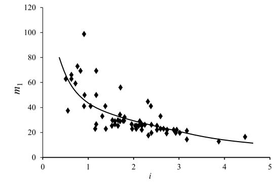
| 广东省 综合 单位线 | ; ; ; | 式中: 为无因次单位线的纵坐标(比值); 为无因次单位线的横坐标(比值); 为时段单位线的纵坐标; 为时段单位线的横坐标; 为时段单位线的上涨历时; W=F/3.6,相当于1 mm的净雨所形成的时段单位的总洪量,F为流域面积;m 1为时段单位线滞时 | 优点:对流域地形地貌条件综合考虑。适用于流域面积<1 000 km2。 |
| 广东省 三角形 综合单位线 | 式中: 为t时刻雨量系列在桥址断面处产生的流量; 为第i时段雨量大小; 为t时刻第i时段雨量对应的单位线纵坐标;n为雨量时段数 | 三角形综合单位线体现了当地的地域特点 | |
| 地貌综合 瞬时单位线 (张静怡,2008) | ; ; | 式中:v为流速; 为a的伽马函数; 为最高级河流长度河长比( )、分叉比( )和面积比( ) | 缺点:分叉比、河长比、面积比受面积影响,从而使流域地貌瞬时单位线不唯一。 |
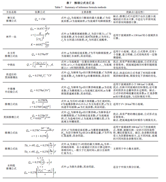
表7 推理公式法汇总Table 7 Summary of inference formula methods |
| 方法名称 | 估算公式 | 主要参数 | 优缺点(适应性) |
|---|---|---|---|
| 摩尔尼 推理公式 | 式中: 为流域出口断面的最大流量; 为径流系数; 为流域面积; 为流域平均降雨强度。 | 缺点:推理公式只适用于山区丘陵小流域的设计洪水计算,不适应与平原河流和平原河网排涝计算。 | |
| 林平一法 |
| 式中:n为暴雨衰减指数; 为设计雨力;;C为径流系数;K为全面汇流时间参数;L为河长; 主河道L的坡度; 为河道汇流糙率。 | 适用于流域面积<150 km2的小流域洪水计算。 |
| 水文所 推理公式法 | 式中: 为洪峰径流系数; 为平均降雨强度; 为流域汇水面积;其余同前。 | 适用于小流域。优点:公式简单,仅有3个变量,意义明确,公式结构具有一定物理基础。 | |
| 中铁法 | 式中:τ为流域某一位置处净雨水质点的汇流时间,w(τ,r)为流域面积增长函数, 为流域面上 时刻的雨强;其余同前。 | 优点:具有严密的理论基础,公式形式也非常简单。把流域造峰历时看作随雨强变化而变化。 | |
| 改进后的 美国推理法 | 式中: 为频率为p的计算洪峰流量;C为洪峰径流系数; 为频率为p的暴雨雨强;其余同前。 | 优点:改进后的公式考虑了时间段对暴雨洪峰的影响,雨强变化下洪峰的变化。 | |
| 半推理 半经验公式 | 式中: 为频率为p的计算洪峰流量; 为径流系数;S为暴雨雨力;τ为流域汇流时间;n为暴雨强度递减系数;其余同前。 | 适用于流域面积小于500 km2小流域。优点:反映不同流域的实际情况;还可推求时段洪水总量和洪水过程线。缺点:公式中的洪峰流量径流系数 、汇流参数m的计算或选取,与实际情况不符。 | |
| 推理公式法 |
| 式中: 为历时t的最大净雨量;τ为汇流时间;θ为地理参数θ=L/J1/3;L为主沟道长度;J为主沟道平均坡降;m为汇流参数;其余同前。 | 适用于F< 20 km2特小流域。 |
| 美国推理公式 |
| 式中: 为频率是p的计算洪峰;i为频率是P的暴雨雨强;C为洪峰径流系数;F为流域面积; 为造峰历时;L为流域主河槽长度;S为流域主河槽坡度。 | 优点:具有严密的理论基础,公式形式也非常简单。 缺点:把流域造峰历时看作与雨强无关。 |
| 推理公式法 |
| 式中:C为洪峰径流系数;n为暴雨衰减指数;H 24 p 为设计频率为p的24 h暴雨总量; 为平均汇流速度;其余同前。 | 适用于流域面积300 km2以下的流域优点:简便,能够反映一定的不同河流特性,理论依据充足。缺点:各参数的取值受人为因素影响很大,且不同河流、流域的不同河段各参数有区别。 |
| 推理公式法 |
| 式中: 为相应于τ时段的最大净雨; 为单一洪峰的净雨.在小流域设计洪水计算过程中,净雨历时 一般大于汇流时间τ,故以全面积汇流为主。 | 主要用于中小集水面积。 |
| 水科院 推理公式 |
| 式中: 为损失参数;其余同前。 | 适合于中国大部分区域。 |
表8 经验公式法汇总Table 8 Summary of empirical formula methods |
| 方法 | 计算公式 | 参数 | 适用性 |
|---|---|---|---|
| 经验公式法 |
| 式中: 为计算断面以上的集水面积; 为洪峰流量均值模数。 | 优点:简便。缺点:反映不同流域特性差,且由于水文图集出版的时间早,系列资料的长短对经验公式本身计算结果的影响大。 |
| 市政部门 经验公式 | 式中: 为汇水时间; 为系数; 为相应设计频率的1 h降雨量。 | 优点:应用简易。缺点:设计洪水选取的标准与水利部门的概念差异较大,公式计算出的仅为洪峰流量,且难以对其计算成果作出了合理分析。 | |
| 广东省 洪峰流量 经验公式法 | 式中: 为某频率的洪峰流量; 为随频率而异的系数; 为24 h设计暴雨量; 为汇流特征参数; 为集水面积。 | 适用性:反映了流域的地理特征和暴雨特征,对于集水面积<10 km2的河流使用效果好。 | |
| 公路科学研究所 经验公式 | 式中: 为设计控制断面处洪峰流量; 为项目区流域面积; 为径流模数; n为面积参数。 | 适用于:面积<10 km2流域。 | |
| 多年平均 年最大洪峰流量 计算 | 式中: 为多年平均最大洪峰流量; 为地理参数; 为多年平均最大日暴雨均值; 为流域面积;n为经验指数。 | 以实测和调查洪水资料为基础,综合考虑影响洪水的暴雨、地形、土壤、流域几何特征及人类活动,分析其与洪峰流量的关系。 |
表9 滞时(m 1)-雨强(i)综合类型Table 9 synthesis types |
| 综合类型 | 地区 | 地区综合公式 | |
|---|---|---|---|
| 同雨强i 建立关系 | 雨强10 mm/h与 地理因子综合 | 安徽江淮山丘区 | (当 ) |
| (当 ) | |||
| 甘肃黄土区 | |||
| 湖南山区 | |||
| 浙江省 | |||
| 广西自治区(Ⅰ) | |||
| 云南区 | |||
| 非线性指数b 地区综合 | 陕西省陕北地区 | ||
| 江西省(Ⅰ区) | |||
| 四川省(Ⅰ区) | |||
| 福建沿海地区 | |||
| 浙江省 | |||
| 公式 中的参数a、b进行地区综合 | 黑龙江省 | ||
| 宁夏贺龙山区 | |||
| 青海浅脑混合区 | |||
| 考虑净雨量 和净雨历时 | 山东省山丘区 | ||
| 不考虑雨强 | 江苏省苏北山区 | ||
| 山东省 | |||
|
表10 不同区域汇流参数(m)-特征参数(θ)定线类型Table 10 Alignment types of paraneter(m)~character parameter (θ) in different area |
| 定线类型 | 地区 | 分类 | 值 |
|---|---|---|---|
| 下垫面 | 山西 | 密闭林区 | |
| 裸露山丘区 | |||
| 贵州 | 山区、强岩溶、植被差 | ||
| 山区、少量岩溶、植被较好 | |||
| 甘肃 | 六盘山土石山林区 | ||
| 黄土区 | |||
| 青海 | 脑山区 | ||
| 浅、脑山区 | |||
| 地区定线 | 四川 | 盆地丘陵区( =1~30) | |
| 青衣江-鹿头山( =1~30) | |||
| 福建 | 沿海( ) | ||
| 内陆( ) | |||
| 洪水大小 | 湖北 | PMP及 >600 mm | 0.36 |
| 一般频率洪水 |
|
表11 汇流特征参数( )取值类型Table 11 Value types of character parameter |
| 值 | 省(区) |
|---|---|
| 湖南、四川、河南、广西、贵州、甘肃、清海、福建、吉林、山西等省(区) | |
| 湖北、内蒙、甘肃、江西等省(区) | |
| 山东 | |
| 陕西的陕北、渭北 |

赵玲玲:文章的整体架构,文章撰写与修改;
刘昌明:文章逻辑结构、思路提供指导;
王梓尹:协助论文修改校对,提供绘图制图支持,提出修改意见;
张鑫辉:完善文章思路,润色文章内容;
杨 兴:前期论文撰写,协助数据资料采集,提出修改意见。
|
暴雨洪水分析计算工作协调小组办公室. 1984. 编制全国《暴雨径流查算图表》技术报告及各省主要成果. 北京:暴雨洪水分析计算工作协调小组办公室.
Office of the Coordinating Group for Storm and Flood Analysis and Calculation. 1984. Compilation of the National Storm Storm Runoff Calculation Chart Technical Report and Major Achievements of Each Province. Beijing: Office of the Coordinating Group for Storm and Flood Analysis and Calculation.
|
|
柏绍光,黄英,方绍东,李自顺. 2008. 资料匮乏地区小流域洪水汇流参数移用分析. 水电能源科学,(3):21-24.
Bai Shaoguang, Huang Ying, Fang Shaodong, and Li Zishun. 2008. Diverting Use Analysis of Flood Confluence Parameter in Small Watersheds Lacking Hydrologic Data. Water Resources and Power, (3): 21-24.
|
|
Berne A, and Krajewski W F. 2013. Radar for Hydrology: Unfulfilled Promise or Unrecognized Potential?. Advances in Water Resources, 51: 357-366.
|
|
Clark C O. 1945. Storage and the Unit Hydrograph. Transaction of the American Society of Civil Engineers, 110: 1419-1446.
|
|
Chow Ven Te. 1959. Discussion of "Divining Rods Versus Hydrologic Data and Research". Journal of Hydraulic Engineering, 85 (1959): 65-66.
|
|
陈家琦,张恭肃. 1985. 小流域暴雨洪水计算. 北京:水利电力出版社.
Chen Jiaqi and Zhang Gongsu. 1985. Calculation of Storm Flood in Small Watershed. Beijing: Water Resources and Electric Power Press.
|
|
陈明,傅抱璞,于强. 1995. 山区地形对暴雨的影响. 地理学报,50(3):256-263.
Chen Ming, Fu Baopu, and Yu Qiang. 1995. Influence of Topography on Storm Rainfall. Acta Geographica Sinica, 50(3): 256-263.
|
|
陈晓宏,钟睿达,王兆礼,赖成光,陈家超. 2017. 新一代GPM IMERG卫星遥感降水数据在中国南方地区的精度及水文效用评估. 水利学报,48(10):1147-1156. DOI:10.13243/j.cnki.slxb.20170202.
Chen Xiaohong, Zhong Ruida, Wang Zhaoli, Lai Chenguang, and Chen Jiachao. 2017. Evaluation on the Accuracy and Hydrological Performance of the Latest: Generation GPM IMERG Product over South China. Journal of Hydraulic Engineering, 48(10): 1147-1156. DOI:10.13243/j.cnki.slxb.20170202.
|
|
Dooge J C I. 1959. A General Theory of the Unit Hydrograph. Journal of Geophysical Research, 64(2): 241-256.
|
|
冯焱. 1983. 论变动等流时线. 水利学报,(9):70-72.
Feng Yan. 1983. On the Constant Flow Line of Change. Journal of Hydraulic Engineering,(9): 70-72.
|
|
Gupta Vijay K, Waymire E D, and Wang C T. 1980. A Representation of an IUH from Geomorphology. Water Resour. Res. 16: 862-885.
|
|
黄金池. 2010. 我国中小河流洪水综合管理探讨. 中国防汛抗旱,20(5):7-8,15.
Huang Jinchi. 2010. Discussion on Integrated Flood Management of Small and Medium-Sized Rivers in China. Flood Control and Drought Relief in China, 20(5): 7-8, 15.
|
|
Horton Robert E. 1939. Analysis of Runoff-Plat Experiments with Varying Infiltration-Capacity. Transactions, American Geophysical Union, 20(4): 693.
|
|
侯轶攀,杨宜军,王鹏来. 2019. 小流域评价单元在地质灾害详细调查易发性分区中的应用. 资源环境与工程,(S1):36-42. DOI:10.16536/j.cnki.issn.1671-1211.2019.S1.008.
Hou Yipan, Yang Yijun, and Wang Penglai. 2019. Application of Small Watershed Evaluation Unit in Detailed Investigation of Geological Hazard Prone Zoning. Resources, Environment and Engineering, (S1): 36-42. DOI:10.16536/j.cnki.issn.1671-1211.2019.S1.008.
|
|
黄膺翰,周青. 2014. 基于霍顿下渗能力曲线的流域产流计算研究. 人民长江,45(5):16-18,23.
Huang Yinghan, and Zhou Qing. 2014. Calculation of Basin Runoff Yield Based on Horton Infiltration Capacity Curve. Yangtze River, 45(5): 16-18, 23.
|
|
华士乾,文康. 1980. 论流域汇流的数学模型(第一部分线性模型). 水利学报,(5):3-14.
Hua Shiqian, and Wen Kang. 1980. A Study on the Mathematical Model of Watershed Flow Concentration(Ⅰ). Journal of Hydraulic Engineering, (5): 3-14.
|
|
Hochreiter S, and Schmidhuber J. 1997. Long Short-Term Memory. Neural Computation, 9(8): 1735-1780.
|
|
Ivanov Valeriy Y, Vivoni R Enrique, Bras Rafael L, and Entekhabi Dara. 2004. Catchment Hydrologic Response with a Fully Distributed Triangulated Irregular Network Model.Water Resources Research, 40: W11102. DOI: 10.1029/2004WR003218.
|
|
Ion Zävoianu. 1985. Chapter I The Drainage Basin as a System Unit. Morphometry of Drainage Basins, 9-25. DOI: 10.1016/s0167-5648(08)70413-1.
|
|
金双彦,蒋昕辉. 2017. 基于霍顿下渗能力曲线的流域产汇流计算. 水资源研究,6(4):317-323.
Jin Shuangyan, and Jiang Xinhui. 2017. Calculation of Basin Production Convergence Based on Horton Infiltration Capacity Curve. Research of Water Resources, 6(4): 317-323.
|
|
靳春蕾. 2005. 城市防洪能力分析研究. 太原:太原理工大学.
Jin Chunlei. 2005. The Analysis and Research on Urban Flood Control. Taiyuan: Taiyuan University of Technology.
|
|
Rodríguez-Iturbe I, and Valdés B J. 1979. The Geomorphologic Structure of Hydrologic Response. Water Resources Research, 15(6): 1409-1420.
|
|
Kwak Jaewon, Han Heechan, Kim Soojun, and Soo Hung. 2021. Is the Deep-Learning Technique a Completely Alternative for the Hydrological Model?: A Case Study on Hyeongsan River Basin, Korea. Stochastic Environmental Research and Risk Assessment, 36: 1615-1629.
|
|
Krajewski W F, and Smith J A. 2002. Radar Hydrology: Rainfall Estimation. Advances in Water Resources, 25: 1387-1394.
|
|
刘金艳. 2011. 秦皇岛汤河流域产汇流参数特性. 南水北调与水利科技,9(4):66-69. DOI:10.3724/SP.J.1201.2011.04066.
Liu Jinyan. 2011. Characteristics of Production and Convergence Parameters in the Tanghe River Basin of Qinhuangdao. South-to-North Water Transfer and Water Conservancy Science & Technology, 9(4):66-69. DOI: 10.3724/SP.J.1201.2011.04066.
|
|
刘昌明,钟骏襄. 1978. 黄土高原森林对年径流影响的初步分析. 地理学报,33(2):112-127.
Liu Changming, and Zhong Junxiang. 1978. The Influence of Forest Cover upon Annual Runoff in the Loess Planteau of China. Acta Geographica Sinica, 33(2): 112-127.
|
|
刘克岩,张子贤. 1985. 对确定推理公式中损失参数μ值的建议. 水文,(3):43.
Liu keyan, and Zhang Zixian. 1985. Suggestions for Determining the Lost Parameter Value in the Reasoning Formula. Journal of China Hydrology, (3): 43.
|
|
Liang X, and Xie Z. 2001. A New Surface Runoff Parameterization with Subgrid-Scale Soil Heterogeneity for Land Surface Models. Advances in Water Resources, 24(9/10): 1173-1193.
|
|
连增蛇,董欢. 2013. 论小流域治理对水土保持的重要性. 城市建设理论研究(电子版),(11):1-4.
Lian Zengshe, and Dong Huan. 2013. On the Importance of Small Watershed Governance to Soil and Water Conservation. Theoretical Research on Urban Construction (Electronic Edition), (11): 1-4.
|
|
刘春元,郭索彦. 1988. 我国水土保持小流域治理的现状与特点. 中国水土保持,(11):24-27,64-65. DOI:10.14123/j.cnki.swcc.1988.11.008.
Liu Chunyuan, and Guo Suoyan. 1988. Current Situation and Characteristics of Small Watershed Governance of Soil and Water Conservation in China. Soil and Water Conservation in China, (11): 24-27, 64-65. DOI: 10.14123/j.cnki.swcc.1988.11.008.
|
|
刘晓燕,刘昌明,党素珍. 2019. 黄土丘陵区雨强对水流含沙量的影响. 地理学报,74(9):1723-1732.
Liu Xiaoyan, Liu Changming, and Dang Suzhen. 2019. Effects of Rainfall Intensity on Sediment Concentration in Loess Hilly Region of China. Acta Geographica Sinica, 74(9): 1723-1732.
|
|
李军,刘昌明,王中根,梁康. 2014. 现行普适降水入渗产流模型的比较研究:SCS与LCM. 地理学报,69(7):926-932.
Li Jun, Liu Changming, Wang Zhonggen, and Liang Kang. 2014. Two University Runoff Yield Models: SCS vs. LCM. Acta Geographica Sinica, 69(7): 926-932.
|
|
刘昌军,周剑,文磊,马强,郭良,丁留谦,孙东亚. 2021. 中小流域时空变源混合产流模型及参数区域化方法研究. 中国水利水电科学研究院学报,(1):99-114. DOI:10.13244/j.cnki.jiwhr.20200161.
Liu Changjun, Zhou Jian, Wen Lei, Ma Qiang, Guo Liang, Ding Liuqian, and Sun Dongya. 2021. Research on Spatiotemporal Variable Source Mixed Production Flow Model and Parameter Regionalization Method in Small and Medium-Sized River Basins. Journal of China Institute of Water Resources and Hydropower Research, (1): 99-114. DOI: 10.13244/j.cnki.jiwhr.20200161.
|
|
李薇,徐海峰,李玉梅. 2019. 高精度降雨雷达设备在局地暴雨监测中的应用. 水文,39(5):67-70.
Li Wei, Xu Haifeng, and Li Yumei. 2019. Application of High-Resolution Rainfall Radar in Local Rainstrom Monitoring. Journal of China Hydrology, 39(5): 67-70.
|
|
Martinovic Jan, Stepan Kuchar, Ivo Vondrák, Vít Vondrák, Boris Nir, and Jan Unucka. 2010. Multiple Scenarios Computing in the Flood Prediction System FLOREON. European Conference on Modelling and Simulation, (Jun.): 182-188.
|
|
马瑜君,邹希. 2018. 基于深度学习的中小河流洪水预报方法研究. 国外电子测量技术,37(12):7-13. DOI:10.19652/j.cnki.femt.1801286.
Ma Yujun, and Zou Xi. 2018. Study on Flood Forecasting Methods of Small and Middle Rivers Based on Deep Learning. Foreign Electronic Measurement Technology. 37(12): 7-13. DOI: 10.19652/j.cnki.femt.1801286.
|
|
Nash J E. 1957. The Form of the Instantaneous Unit Hydrograph. Hydrological Sciences Bulletin, 45(3): 114-121.
|
|
Rosso Renzo. 1984. Nash Model Relation to Horton Order Ratios. Water Resources Research, 20(7): 914-920.
|
|
芮孝芳. 1999a. 利用地形地貌资料确定Nash模型参数的研究. 水文,(3):6-10.
Rui Xiaofang. 1999a. A Study on Determining the Parameters of the Nash Model Using Geomorphological Data. Hydrology, (3): 6-10.
|
|
芮孝芳. 1999b. 地貌瞬时单位线研究进展. 水科学进展,(3):345-350.
Rui Xiaofang. 1999b. Some Advances in Geomorphologic Instantaneous Unit Hydrograph Theory. Advances in Water Science, (3): 345-350.
|
|
芮孝芳,刘宁宁,凌哲. 2012. 单位线的发展及启示. 水利水电科技进展,32(2):1-5.
Rui Xiaofang, Liu Ningning, and Ling Zhe. 2012. Development and Inspiration of Unit Hydrograph. Advances in Science and Technology of Water Resources, 32 (2): 1-5.
|
|
芮孝芳. 2017. 单元嵌套网格产汇流理论. 水利水电科技进展,37(2):1-6.
Rui Xiaofang. 2017. Theory of Runoff Yield and Confluence by Grid Inlaid in Watershed Basic Unit. Advances in Science and Technology of Water Resource, 37(2): 1-6.
|
|
水利科学研究院. 1958. 小汇水面积雨洪最大径流图解分析法(水利科学研究报告第7号). 北京:水利电力出版社.
Hydraulic Research Institude. 1958. Graphical Analysis Method of Maximum Rainwater Runoff in Small Catchment Area (Hydraulic Science Research Report No.7). Beijing: Water Conservancy and Electric Power Press.
|
|
水利部水文局. 2010. 水文情报预报技术手册. 北京:中国水利水电出版社.
China Hydrology. 2010. Hydrological Information Forecast Technical Manual. Beijing: China Water&Power Press.
|
|
水利部水土保持监测中心. 2013. 小流域划分及编码规范. 北京:中华人民共和国水利部,51.
Monitoring Center of Soil and Water Conservation,Ministry of Water Resources. 2013. Specification for Division and Encoding of Small Wateshed.Beijing: Ministry of Water Resources of the People's Republic of China, 51.
|
|
Swain Janaki Ballav, and Patra Kanhu Charan. 2017. Streamflow Estimation in Ungauged Catchments Using Regionalization Techniques. Journal of Hydrology, 554(7): 04017010.
|
|
Sherman L K. 1932. Stream Flow from Rainfall by the Unit Graph Method. Engineering News-Record, 108: 501-505.
|
|
Snyder F F. 1938. Synthetic Unit Graphs. Transactions American Geophysics Union, 19: 447-454.
|
|
苏伟忠,汝静静,杨桂山. 2019. 流域尺度土地利用调蓄视角的雨洪管理探析. 地理学报,74(5):948-961.
Su Weizhong, Ru Jingjing, and Yang Guishan. 2019. Modelling Stormwater Management Based on Infiltration Capacity of Land Use in the Watershed Scale. Acta Geographica Sinica, 74(5): 948-961.
|
|
舒晓娟. 2004. 广州抽水蓄能电站设计洪水研究. 武汉:武汉大学.
Shu Xiaojuan. 2004. Study on Design Flood of Guangzhou Pumped Storage Station. Wuhan: Wuhan University.
|
|
Thomas Dunne, and Richard D Black. 1970. An Experimental Investigation of Runoff Production in Permeable Soils. Water Resources Research, 6(2): 478-490. DOI: 10.1029/wr006i002p00478.
|
|
王广德,吴凯. 1981. 几种水文概念性模型的阶跃函数解. 水文,(4):13-19. DOI:10.19797/j.cnki.1000-0852.1981.04.003.
Wang Guangde, and Wu Kai. 1981. Step Function Solutions for Several Hydrological Conceptual Models. Hydrology, (4): 13-19. DOI: 10.19797/j.cnki.1000-0852.1981.04.003.
|
|
王淑云,钟向伟. 2017. 库设计洪水计算研究. 湖南水利水电,(1):46-47.
Wang Shuyun, and Xiang Wei. 2017. Study on Design Flood Calculation of Mangshan Reservoir. Hunan Water Conservancy and Hydropower, (1): 46-47.
|
|
王淼. 2013. 基于排水管网中心城区小流域划分方法研究. 北京测绘,(5):16-18. DOI:10.19580/j.cnki.1007-3000.2013.05.004.
Wang Miao. 2013. Research on the Division Method of Small Watershed in the Central Urban Area of Drainage Pipe Network. Beijing Surveying and Mapping, (5): 16-18. DOI: 10.19580/j.cnki.1007-3000.2013.05.004.
|
|
王博,崔明霞. 2009. 城镇小汇水面积设计洪水计算方法比较. 中国农村水利水电,(10):84-86,93.
Wang Bo, and Cui Mingxia. 2009. Comparison of Design Flood Calculation Methods for Small Catchment Area in Cities and Towns. Rural Water Conservancy and Hydropower in China,(10): 84-86, 93.
|
|
吴健生,张朴华. 2017. 城市景观格局对城市内涝的影响研究——以深圳市为例. 地理学报,72(3):444-456.
Wu Jiansheng, and Zhang Puhua. 2017. The Effect of Urban Landscape Pattern on Urban Waterlogging. Acta Geographica Sinica, 72(3): 444-456.
|
|
汪君,王会军,Hong Yang. 2016a. 一个新的高分辨率洪涝动力数值监测预报系统. 科学通报,61(Z1):518-528.
Wang Jun, Wang Huijun, and Hong Yang. 2016aa. A High-Resolution Flood Forecasting and Monitoring System for China Using Satellite Remote Sensing Data. Chinese Science Bulletin, 61(Z1): 518-528.
|
|
Wang Jun, Wang Huijun, and HongYang. 2016b. Comparison of Satellite-Estimated and Model-Fforecasted Rainfall Data during a Deadly Debris-Flow Event in Zhouqu, Northwest China. Atmospheric and Oceanic Science Letters, 9(2): 139-145. DOI:10.1080/16742834.2016.1142825.
|
|
小流域暴雨径流研究组. 1978. 小流域暴雨洪峰流量计算. 北京:科学出版社,104-121.
Small Watershed Rainstorm Runoff Study Group. 1978. The Calculation of Flood Peak Discharge during Rainstorm in Small Watersheds. Beijing: Science Press, 104-121.
|
|
谢莹莹,刘遂庆,信昆仑. 2006. 城市暴雨模型发展现状与趋势. 重庆建筑大学学报,(5):136-139.
Xie Yingying, Liu Suiqing, and Xin Kunlun. 2006. Present Situation and Trend of Urban Storm Water Model Development. Journal of Civil and Environmental Engineering, (5):136-139.
|
|
夏军. 1982. 非线性水文系统识别方法的探讨. 水利学报,(8):24-33.
Xia Jun. 1982. An Approach to the Method of Nonlinear Hydrologic System Identification. Journal of Hydraulic Engineering, (8): 24-33.
|
|
王国安,贺顺德,李超群,李荣容,盖永岗,崔鹏. 2011. 论广东省综合单位线的基本原理和适用条件. 人民黄河,(3):15-18.
Wang Guo'an, He Shunde, Li Chaoqun, Li Rongrong, Gai Yonggang, and Cui Peng. 2011. On the Basic Principle and Applicable Conditions of Integrated Unit Line in Guangdong Province. Yellow River, (3): 15-18.
|
|
邢贞相,傅爽,孙明新,纪毅,付强,李衡. 2020. 遥感蒸散发在无测站资料地区洪水模拟中的应用. 东北农业大学学报,51(2):78-85. DOI:10.19720/j.cnki.issn.1005-9369.2020.02. 0010. [Xing Zhenxiang, Fu Shuang, Sun Mingxin, Ji Yi, Fu Qiang, and Li Heng. 2020. Application of Remote Sensing Evapotranspiration in Flood Simulation in Ungauged Basins. Journal of Northeast Agricultural University, 51(2): 78-85. DOI: 10.19720/j.cnki.issn.1005-9369.]
|
|
徐海飞,谭显辉,朱自伟,刘国. 2016. 高分辨率遥感降水对强降雨的监测能力研究. 科学技术与工程,16(10):178-185.
Xu Haifei, Tan Xianhui, Zhu Ziwei, and Liu Guo. 2016. Study on the Monitoring Capacity of High Resolution Satellite Precipitati-on on Heavy Rainfall. Science Technology and Engineering, 16(10):178-185.
|
|
俞芳琴. 2008. 滁河流域中下游区域城市防洪研究. 南京:河海大学.
Yu Fangqin. 2008. Study on Urban Flood Control in the Middle and Lower Reaches of Chuhe River Basin. Nanjing: Hohai University.
|
|
杨兴. 2020. 华南强降雨地区中小流域设计暴雨洪水参数计算与综合. 淮南:安徽理工大学. DOI:10.26918/d.cnki.ghngc.2020.000325.
Yang Xing. 2020. Calculation and Synthesis of Design Storm and Flood Parameters in Medium and Small Watersheds in Heavy Rain Areas in South China. Huainan: Anhui University of Science and Technology. DOI: 10.26918/d.cnki.ghngc.2020.000325.
|
|
叶贵明,傅世伯. 1982. 从东峡水库洪水复核谈编制《暴雨径流查算图表》的几个问题. 水文,(3):13-18.
Ye Guiming, and Fu Shibo. 1982. This Paper Discusses Some Problems in Compiling the Chart of Stormwater Runoff from Dongxia Reservoir Flood Review. Journal of China Hydrology, (3): 13-18.
|
|
杨家坦. 1981. 小流域汇流非线性模式的研究. 地理学报,36(4):442-449.
Yang Jiatan. 1981. Study on Nonlinear Model of Confluence in Small Watershed. Acta Geographica Sinica, (4): 442-449.
|
|
杨扬,张建云,戚建国,岳智慧. 2000. 雷达测雨及其在水文中应用的回顾与展望. 水科学进展,(1):92-98.
Yang Yang, Zhang Jianyun, Qi Jianguo, and Yue Zhihui. 2000. Review and Prospect on the Application of Weather Radar in Hydrology. Advances in Water Science, (1): 92-98.
|
|
赵鸣雁. 2001. 城市地区中小流域防洪预报系统研究,济南:山东大学.
Zhao Mingyan. 2001. Study on Flood Control Forecast System of Small and Medium-Sized Watersheds in Urban Areas. Jinan: Shandong University.
|
|
詹道江. 2010. 工程水文学. 北京:中国水利水电出版社.
Zhan Daojiang. 2010. Engineering Hydrology. Beijing: China Water & Power Press.
|
|
赵玲玲,刘昌明,吴潇潇,刘丽红,王中根,苏磊. 2016. 水文循环模拟中下垫面参数化方法综述. 地理学报,71(7):1091-1104.
Zhao Lingling, Liu Changming, Wu Xiaoxiao, Liu Lihong, Wang Zhonggen, and Su Lei. 2016. A Review of Underlying Surface Parametrization Methods in Hydrologic Models. Acta Geographica Sinica, 71(7): 1091-1104.
|
|
张一龙,王红武,秦语涵. 2015. 城市地表产流计算方法和径流模型研究进展. 四川环境,34(1):113-119.
Zhang Yilong, Wang Hongwu, and Qin Yuhan. 2015. Review of Urban Surface Runoff Calculation Method and Relevant Models. Sichuan Environment, 34(1): 113-119.
|
|
周理,刘星,黎小东,张洪波,敖天其. 2014. 小流域农业非点源污染防治措施探究——以濑溪河(泸县境内)为例. 中国农村水利水电,(5):7-10,14.
Zhou Li, Liu Xing, Li Xiaodong, Zhang Hongbo, and Ao Tianqi. 2014. Investigation on Agricultural Non-Point Source Pollution Prevention and Control Measures in Small Watersheds: A Case Study of Sexi River (in Luxian County). China Rural Water Resources and Hydropower,(5): 7-10, 14.
|
|
张婷婷,王铁良,孙毅. 2007. 城市雨水产汇流过程损失研究. 灌溉排水学报,26(4):180-181.
Zhang Tingting, Wang Tieliang, and Sun Yi. 2007. Study on the Confluence Loss of Urban Rain Aquatic Products. Journal of Irrigation and Drainage, 26 (4): 180-181.
|
|
张恭肃,黄守信,贺伟程,庾维德. 1981. 小流域单位线的非线性分析. 水利学报,(3):1-9.
Zhang Gongsu, Huang Shouxin, He Weicheng, and Yu Weide. 1981. Nonlinear Analysis of Small Watershed Unit Lines. Journal of Hydraulic Engineering, (3): 1-9.
|
|
张静怡. 2008. 水文分区及区域洪水频率分析研究. 南京:河海大学.
Zhang Jingyi. 2008. Study on Hydrological Division and Regional Flood Frequency Analysis. Nanjing: Hohai University.
|
|
赵珂,夏清清. 2015. 以小流域为单元的城市水空间体系生态规划方法——以州河小流域内的达州市经开区为例. 中国园林,(1):41-45.
Zhao Ke, and Xia Qingqing. 2015. Ecological Planning Method of Urban Water Spatial System with Small Watershed as Unit: A Case Study of Dazhou Economic Development Zone in Small Watershed of Zhouhe. Chinese Landscape Architecture, (1): 41-45.
|
|
张桂娇,刘筱琴,李水金,熊小群. 2004. 江西省小流域暴雨洪水参数地理规律探讨. 江西水利科技,(1):23-27.
Zhang Guijiao, Liu Xiaoqin, Li Shuijin, and Xiong Xiaoqun. 2004. Discussion on the Geographical Law of Heavy Rainfall and Flood Parameters in Small Watersheds of Jiangxi Province. Jiangxi Water Conservancy Science and Technology, (1): 23-27.
|
|
郑章忠,石向荣. 2002. 小流域治理规划中的水文分析. 浙江水利科技,(3):15-17.
Zheng Zhangzhong, and Shi Xiangrong. 2002. Hydrologic Analysis in Regulation Planning of Small Watershed. Zhejiang Hydrotechnics, (3): 15-17.
|
|
Zeng Ziyue, Tang Guoqiang, Long Di, Zeng Chao, Ma Meihong, Hong Yang, Xu Hui, and Xu Jing. 2016. A Cascading Flash Flood Guidance System: Development and Application in Yunnan Province, China. Natural Hazards, 84(3): 2071-2093.
|
|
Zhu Dehua, Echendu Shirley, Xuan Yunqing, Webster Mike and Cluckie Lan. 2016. Coupled Hydro-Meteorological Modelling on a HPC Platform for High-Resolution Extreme Weather Impact Study. Hydrology and Earth System Sciences, 20(12): 4707-4715.
|
/
| 〈 |
|
〉 |