
数据赋能下的智慧国土空间规划实践——以广州为例
|
邓毛颖(1973—),男,广东徐闻人,教授级高级工程师,博士,研究方向为城乡发展与规划、交通规划和土地经济,(E-mail)26886688@qq.com; |
收稿日期: 2023-05-19
修回日期: 2023-06-25
网络出版日期: 2023-12-15
基金资助
国家社会科学基金项目“多空间尺度视角下粤港澳大湾区协同创新发展研究”(19BJY064)
Data-Assisted Smart Territorial Spatial Planning Practice: A Case Study of Guangzhou
Received date: 2023-05-19
Revised date: 2023-06-25
Online published: 2023-12-15
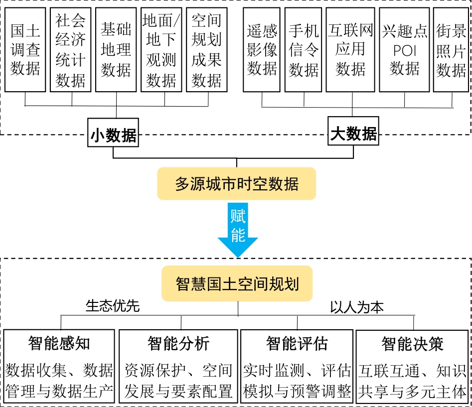
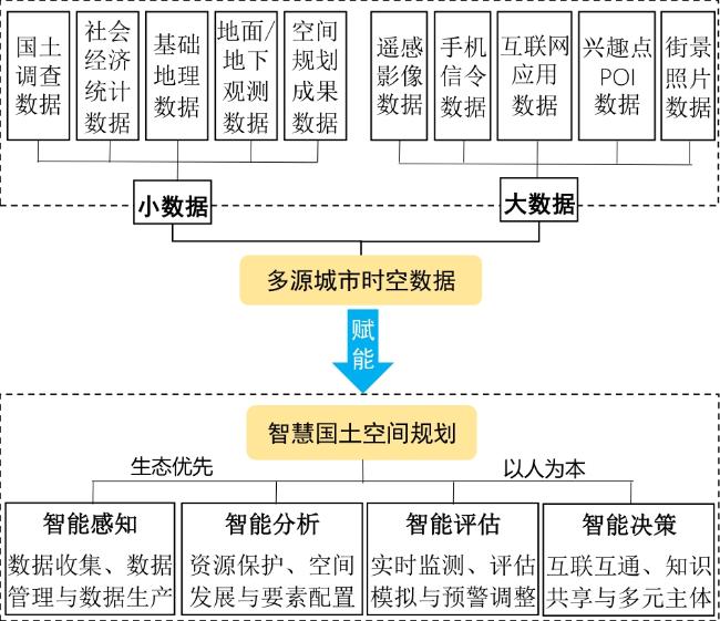
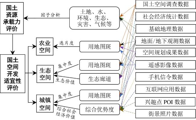
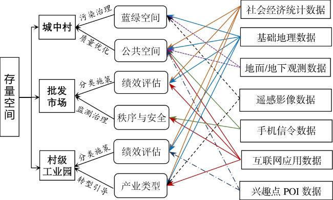
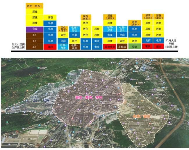
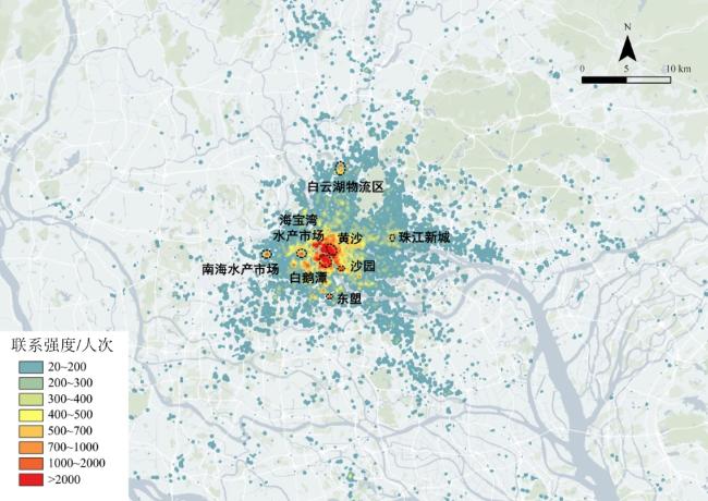
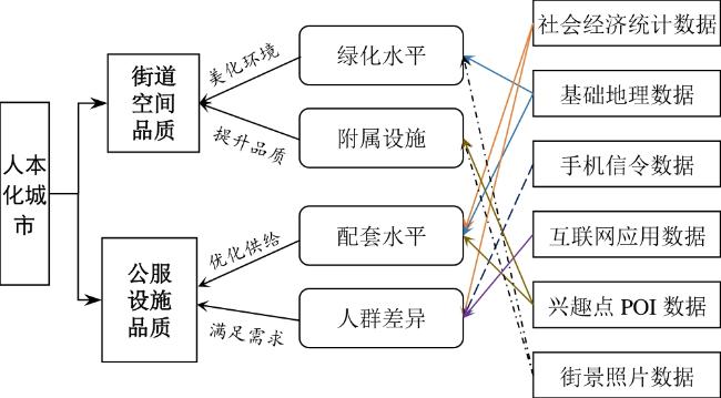
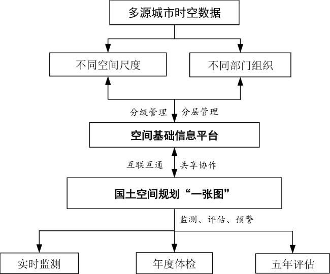
多源城市时空数据使得智慧国土空间规划实践成为可能。文章以“生态优先、以人为本”为基本原则,构建一个总体的智慧国土空间规划与数据应用框架,并以广州为案例,从可持续发展、高质量发展、高品质生活、高水平治理4个维度,探究多源城市时空数据如何赋能智慧国土空间规划编制、审批和实施监督。多源城市时空数据应用于构建美丽国土空间,可提高“双评价”、“三区三线”划定的精确性、科学性;应用于存量空间治理,为空间功能优化配置、空间载体分类施策和提质增效提供科学依据;应用于人本化城市建设,助力城市空间需求差异性的深入挖掘,促进城市服务品质整体提升;应用于国土空间动态规划管理,通过国土空间基础信息平台实现数据集成,为国土空间的监测、评估、预警提供了强有力的数据保障。智慧国土空间规划未来应建立规范化的数据渠道与应用标准、加强多源数据整合及“一张图”平台建设、充分吸收跨领域理论与技术,以推进国土空间治理体系和治理能力现代化。
邓毛颖 , 邓策方 . 数据赋能下的智慧国土空间规划实践——以广州为例[J]. 热带地理, 2023 , 43(12) : 2311 -2320 . DOI: 10.13284/j.cnki.rddl.003781
In recent years, the state has promulgated a series of policies aimed at establishing a national territorial spatial planning system and advocating for the creation of an integrated "multi-regulation in one" system. The issuance of these policies marked the formal commencement of constructing the territorial spatial planning system. Territorial space is a type of environment, and the description of its functions essentially elucidates the relationship between humans and land. This relationship represents a complex interplay of static and dynamic interactions among elements such as stakeholders, the environment, and activities within a defined spatiotemporal framework of the system. In the new era, territorial spatial planning is required to perceive, analyze, evaluate, and decide upon various resource elements and the spatiotemporal information of diverse activities of people within a national territory. Multi-source urban spatiotemporal data empowers the intelligent processes of perception, analysis, evaluation, and decision-making regarding these resources and activities, propelling the evolution from traditional to smart territorial spatial planning. This study aimed to construct a comprehensive framework for smart territorial spatial planning and multi-source urban spatiotemporal data application to promote the modernization of the territorial governance system and its capabilities. This was done by adhering to the fundamental principles of "ecological priority" and "human-centricity." Taking Guangzhou as an example, this study investigated how multi-source urban spatiotemporal data empowers the drafting, approval, and supervisory execution of smart territorial spatial planning. Multi-source urban spatiotemporal data support territorial spatial planning in four dimensions: sustainable development, high-quality growth, high-quality living, and high-level governance. For sustainable development, spatiotemporal data obtained from land surveys, ground/subterranean observations, and spatial planning outcomes, bolster the assessment of land resource carrying capacity and suitability evaluation for territorial development. This approach fosters optimized layouts for ecological, agricultural, and urban spaces and propel the construction of beautiful territorial spaces. Regarding high-quality growth, spatiotemporal data provide a robust foundation for data support and decision-making in national territorial space governance. In urban villages, multi-source data aid in enhancing the quality of high-density mixed-use spaces. In wholesale markets, data analyses assist in the optimal allocation of spatial resources, promoting orderly governance. In village-level industrial parks, spatiotemporal data underpin classified policymaking, refining industrial layouts. In terms of high-quality living, multi-source urban spatiotemporal data support the construction of diverse human-centric cities by precisely quantifying the level of street greening and estimating the demand for various public services. Regarding high-level governance, multi-source data facilitate the monitoring, assessment, and early warning of territorial space resources as well as the scientific adjustment and decision-making of related management measures. This data-driven planning approach provides scientific decision-making support for high-level urban governance, marking a transition toward more intelligent and refined territorial spatial planning. However, practicing smart territorial spatial planning in Guangzhou not only validates the empowering role of multi-source urban spatiotemporal data but also exposes the challenges in its application. The acquisition of multi-source urban spatiotemporal data is difficult and costly, and the absence of unified application guidelines presents challenges in data acquisition and comparison of analytical results. Consequently, the future research on smart territorial spatial planning should focus on establishing standardized data channels and application norms, enhancing the multi-source data integration and the construction of a "one map" platform, and fully incorporating interdisciplinary theories and technologies.
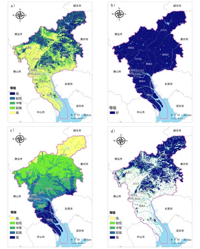
图3 广州市生态环境类时空数据分析与应用(a. 农业生产适宜性土地等级;b. 农业生产适宜性水资源等级;c. 气象灾害危险性等级;d. 植被覆盖度分布)Fig.3 Ecological and environmental data of Guangzhou city (a. Grade of suitable land for agricultural production; b. Grade of suitable water for agricultural production; c. Grade of meteorological disaster risk; d. Distribution of vegetation coverage) |

邓毛颖:研究成果核心完成人、主要执笔人,主导研究选题、研究技术路线制定;
邓策方:主要执笔人,主要参与研究技术路线制定、核心研究成果输出。
|
Becker R A, Caceres R, Hanson K, Loh J M, Urbanek S, Varshavsky A, and Volinsky C. 2011. A Tale of One City: Using Cellular Network Data for Urban Planning. Pervasive Computing, IEEE,10(4):18-26.
|
|
柴彦威,龙瀛,申悦. 2014. 大数据在中国智慧城市规划中的应用探索.国际城市规划,29(6):9-11.
Chai Yanwei, Long Ying, and Shen Yue. 2014. Big Data Application in China's Smart City Planning. Urban Planning International, 29(6): 9-11.
|
|
陈明星,梁龙武,王振波,张文忠,余建辉,梁宜. 2019. 美丽中国与国土空间规划关系的地理学思考. 地理学报,74(12):2467-2481.
Chen Mingxing, Liang Longwu, Wang Zhenbo, Zhang Wenzhong, Yu Jianhui, and Liang Yi. 2019. Geographical Thinking on the Relationship between Beautiful China and Land Spatial Planning. Acta Geographica Sinica, 74(12): 2467-2481.
|
|
邓毛颖,谢理. 2000. 广州市居民出行特征分析及交通发展的对策.城市规划,24(11):45-49.
Deng Maoying, and Xie Li. 2000. The Characteristics of the Trips of the Local Residents and the Transport Policy in Guangzhou. City Planning Review, 24(11): 45-49.
|
|
邓毛颖. 2015. 智慧城市与智慧的城市规划. 华南理工大学学报(社会科学版),17(3):49-56.
Deng Maoying. 2015. Smart City and Wise Urban Planning. Journal of South China University of Technology (Social Science Edition), 17(3): 49-56.
|
|
邓毛颖. 2020. 危机与转机:突发公共卫生事件下的城市应对思考——以广州为例. 华南理工大学学报(社会科学版),22(3):76-82.
Deng Maoying. 2020. Crisis and Turnaround: Urban Response to Public Health Emergencies: Case Study of Guangzhou. Journal of South China University of Technology (Social Science Edition), 22(3): 76-82.
|
|
邓毛颖,邓策方. 2021. 利益统筹视角下的城市更新实施路径——以广州城中村改造为例. 热带地理,41(4):760-768.
Deng Maoying, and Deng Cefang. 2021. Assessment of the Implementation Path of Urban Renewal from the Perspective of Interest Coordination: A Case Study on Guangzhou Urban Village Redevelopment. Tropical Geography, 41(4): 760-768.
|
|
邓毛颖,邓策方,王洋. 2022. 广东省建设用地供给与管理策略研究——基于国土空间高质量发展导向. 中国国土资源经济,35(6):36-42.
Deng Maoying, Deng Cefang, and Wang Yang. 2022. Study on Construction Land Supply and Management Strategy in Guangdong Province: Based on Orientation of High-Quality Development of Territorial Space. Natural Resource Economics of China, 35(6): 36-42.
|
|
国土资源部.2012.国土资源部关于印发《国土资源信息化“十二五”规划》的通知. 国土资源通讯,(5):19-28.
Ministry of Land and Resources. 2012. The Notice of the Ministry of Land and Resources on the Issuance of the 12th Five-Year Plan on Land and Resources Informatization. Land Resources Communications, (5): 19-28.
|
|
孔宇,甄峰,李兆中,傅行行. 2019. 智能技术辅助的市(县)国土空间规划编制研究. 自然资源学报,34(10):2186-2199.
Kong Yu, Zhen Feng, Li Zhaozhong, and Fu Xingxing. 2019. Research on Smart Technology-Assisted Territorial Spatial Planning: A Case Study at City and County Level. Journal of Natural Resources, 34(10): 2186-2199.
|
|
Li Deren, Shan Jie, Shao Zhenfeng, Zhou Xiran, and Yao Yuan. 2013. Geomatics for Smart Cities-Concept, Key Techniques, and Applications. Geo-Spatial Information Science, 16(1): 12.
|
|
李德仁,姚远,邵振峰. 2014. 智慧城市中的大数据.武汉大学学报(信息科学版),39(6):631-640.
Li Geren, Yao Yuan, and Shao Zhenfeng. 2014. Big Data in Smart Cities. Journal of Wuhan University (Information Science), 39(6): 631-640.
|
|
李满春,陈振杰,周琛,张鸿辉,黄秋昊. 2020. 面向“一张图”的国土空间规划数据库研究.中国土地科学,34(5):69-75.
Li Manchun, Chen Zhenjie, Zhou Chen, Zhang Honghui, and Huang Qiuhao. 2020. "One Map" Oriented Database Investigation for Territorial Space Planning. China Land Sciences, 34(5): 69-75.
|
|
钮心毅,丁亮,宋小冬.2014.基于手机数据识别上海中心城的城市空间结构.城市规划学刊,(6):61-67.
Niu Xinyi, Ding Liang, and Song Xiaodong. 2014. Understanding Urban Spatial Structure of Shanghai Central City Based on Mobile Phone Data. Urban Planning Forum, (6): 61-67.
|
|
秦萧,甄峰,李亚奇,陈浩.2019.国土空间规划大数据应用方法框架探讨.自然资源学报,34(10):2134-2149.
Qin Xiao, Zhen Feng, LiYaqi, and Chen Hao. 2019. Discussion on the Application Framework of Big Data in Territorial Spatial Planning. Journal of Natural Resources, 34(10): 2134-2149.
|
|
Shafizadeh-Moghadam H, Asghari A, Tayyebi A, and Taleai M.2017. Coupling Machine Learning, Tree-Based and Statistical Models with Cellular Automate to Stimulate Urban Growth. Computers, Environment and Urban Systems, 64: 297-308.
|
|
王波,甄峰,张浩. 2015. 基于签到数据的城市活动时空间动态变化及区划研究. 地理科学,35(2):151-160.
Wang Bo, Zhen Feng, and Zhang Hao.2015. The Dynamic Changes of Urban Space-Time Activity and Activity Zoning Based on Check-In Data in Sina Web. Scientia Geographica Sinica, 35(2): 151-160.
|
|
魏旭红,开欣,王颖,郁海文. 2019. 基于“双评价”的市县级国土空间“三区三线”技术方法探讨. 城市规划,43(7):10-20.
Wei Xuhong, Kai Xin, Wang Ying, and Yu Haiwen. 2019. Discussion on the Methods of "Three Zones and Three Lines" Implementation at the Spatial Levels of City and Country Based on "Double Evaluations". City Planning Review, 43(7): 10-20.
|
|
甄峰,秦萧.2014.大数据在智慧城市研究与规划中的应用.国际城市规划,29(6):44-50.
Zhen Feng, and Qin Xiao. 2014. Application of Big Data in Smart City Research and Planning. International Urban Planning, 29(6): 44-50.
|
|
甄峰,王波,秦萧,陈映雪,席广亮. 2015. 基于大数据的城市研究与规划方法创新.北京:中国建筑工业出版社.
Zhen Feng, Wang Bo, Qin Xiao, Chen Yingxue, and Xi Guangliang. 2015. Urban Studies and Innovation in Urban Planning Method Based on Big Data. Beijing: China Architecture & Building Press.
|
|
甄峰,张姗琪,秦萧,席广亮.2019.从信息化赋能到综合赋能:智慧国土空间规划思路探索.自然资源学报,34(10):2060-2072.
Zhen Feng, Zhang Shanqi, Qin Xiao, and Xi Guangliang. 2019. From Informational Empowerment to Comprehensive Empowerment: Exploring the Ideas of Smart Territorial Spatial Planning. Journal of Natural Resources, 34(10): 2060-2072.
|
|
钟炜菁,王德,谢栋灿,晏龙旭.2017.上海市人口分布与空间活动的动态特征研究:基于手机信令数据的探索.地理研究,36(5):972-984.
Zhong Weijing, Wang De, Xie Dongcan, and Yan Longxu. 2017. Dynamic Characteristics of Shanghai's Population Distribution Using Cell Phone Signaling Data. Geographical Research, 36(5): 972-984.
|
|
中共中央,国务院. 2019. 中共中央 国务院关于建立国土空间规划体系并监督实施的若干意见(中发〔2019〕18号). (2019-05-23)[2023-11-04]. https://www.gov.cn/zhengce/2019-05/23/content_5394187.htm.
The Central Committee of the Communist Party of China and the State Council. 2019. Several Opinions of the CPC Central Committee and the State Council on Establishing a Territorial Spatial Planning System and Supervising Its Implementation No.18 [2019] of the CPC Central Committee). (2019-05-23 [2023-11-04]. https://www.gov.cn/zhengce/2019-05/23/content_5394187.htm.
|
|
庄少勤.2019.新时代的空间规划逻辑.中国土地,(1):4-8.
Zhuang Shaoqin. 2019. Logic of Spatial Planning in the New Era. China Land, (1): 4-8.
|
|
庄少勤,赵星烁,李晨源. 2020. 国土空间规划的维度和温度. 城市规划,44(1):9-13,23.
Zhuang Shaoqin, Zhao Xingshuo, and Li Chenyuan. 2020. Dimension and Temperature of the Spatial Planning. City Planning Review, 44(1): 9-13, 23.
|
/
| 〈 |
|
〉 |