
水生态系统韧性视角下热带雨林地区的蓝绿空间评价——以五指山市南圣河为例
|
车乐(1981―),女,陕西神木人,副教授,博士,研究方向为城乡可持续发展规划、智慧城市、康养社区,(E-mail)838583378@qq.com。 |
收稿日期: 2023-04-03
修回日期: 2024-03-04
网络出版日期: 2024-04-10
基金资助
国家自然科学基金面上项目(52178037)
Blue-Green Spatial Evaluation of Tropical Rainforest Areas from the Perspective of Water Ecosystem Resilience: A Case Study of the Nansheng River in Wuzhishan City
Received date: 2023-04-03
Revised date: 2024-03-04
Online published: 2024-04-10
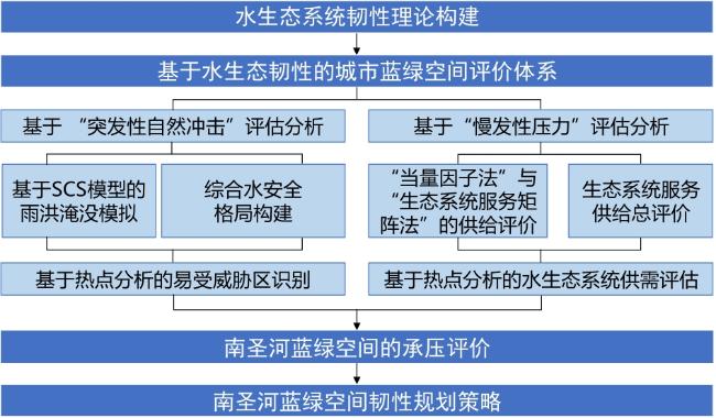
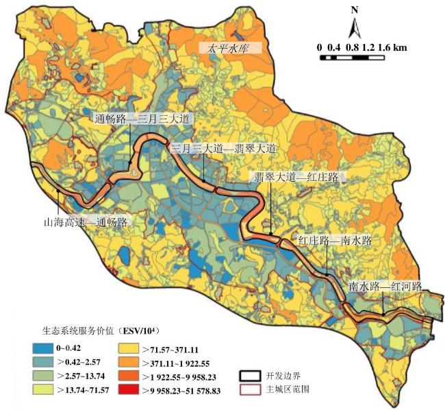
热带雨林地区因特殊的气候特点及空间特征,河流蓝绿空间面临的雨洪压力与人类社会活动压力较大,其韧性建设对于整个生境具有关键性影响。国内外研究聚焦于韧性承洪实践与韧性评估量化,鲜有基于不同生态压力冲击对河流蓝绿空间开展多维韧性评价。文章以南圣河为对象,基于雨洪等自然灾害的脉冲式压力与人类社会对生态系统施加的慢性压力两类情境,构建水生态系统的“压力-脉冲-韧性”模型,通过“构建理论模型―叠合双维承压评价―解析吻合/冲突点―探析韧性策略”的逻辑方法实现特定地域蓝绿空间的评价与优化。研究发现:1)生态系统服务价值越高,调节功能越高,蓝绿空间韧性越强。2)突发性脉冲方面,在极端日降雨量增加情景下,河流水系的缓冲半径与水源类型密切相关,水库受到水安全威胁的风险大于河流,地表的径流曲线数值(简称CN)一般与历史经验相关。3)慢发性压力方面,韧性压力与城市人口密切相关,人口越密集,韧性压力越大;且不同季候的游憩密度与丰枯期存在分异,丰水期雨洪威胁大,游憩密度低,枯水期雨洪威胁小,游憩密度高。
车乐 , 李媛钰 , 赵渺希 , 叶鸿任 . 水生态系统韧性视角下热带雨林地区的蓝绿空间评价——以五指山市南圣河为例[J]. 热带地理, 2024 , 44(4) : 709 -723 . DOI: 10.13284/j.cnki.rddl.003857
In tropical rainforest regions, rivers face significant challenges from stormwater, flooding, and human activities, making the construction of resilience in their blue-green spaces critical for overall habitat sustainability. While domestic and international studies have focused on resilient flood management practices and quantitative resilience evaluations, there is a lack of assessments specifically addressing the resilience of river blue-green spaces under different ecological pressure impacts. To address this gap, this study incorporates the "pulse" and "pressure" methods into the Pressure-Pulse-Resilience model to measure the resilience of blue-green spaces. This study also develops a theoretical framework for the resilience of aquatic ecosystems by linking societal and ecological factors. The resilience evaluation route consists of four steps: theoretical model construction, pressure-bearing evaluation superposition, analysis of coincidence and conflict points, and resilience planning strategy layout. To achieve the two main objectives of ensuring a balance between water supply and demand for both water security patterns and ecosystem services, this thesis delves into the regulatory mechanisms of river resilience, adaptation, and recovery, providing valuable insights into the spatial resilience planning of rivers in such regions. By focusing on the Nansheng river in Wuzhishan city as a practical case, this study conducted a multidimensional resilience assessment to cope with the frequent occurrence of water security vulnerable zones or the imbalance between the supply and demand of ecosystem services under double ecological pressure. Using advanced simulation methods, such as the SCS-CN model, the Equivalent Factor Approach, and the Hot Spot Analysis Method, the study identified distinct zones that are prone to stormwater and flood inundation, zones at risk of water safety threats, and zones experiencing a mismatch between water supply and demand in the blue-green space. Based on the identification of resilience deficiencies, including multiple stormwater threat zones, an imbalance between supply and demand of ecosystem services, and the seasonal nature of slow pressures, the thesis proposes three planning strategies: first, an ecological security pattern and zoning control approach is suggested based on stormwater and flood pulses to improve the resilience to cope with sudden pulses, following the principle of bottom-line control. Second, a demand-oriented blue-green space planning and service supply strategy was proposed to coordinate the slow-onset pressure on the blue-green spaces of rivers caused by the demands of residents for daily life and recreation, integrating land space and other related planning to balance the supply and demand of the social-ecological system. Lastly, the study advocates for the construction of dynamic and adaptive resilience facilities that cater to the seasonal changes in ecological pressure faced by the blue-green space in tropical rainforest regions, in fulfillment of multidimensional and multilevel water resilience requirements, that is, water security, water ecology, water landscape, water function, and water vitality. In summary, this study presents an innovative theoretical framework for water ecosystem resilience, utilizing the measurable concepts of "pulse" and "pressure." Through an empirical case study of the Nansheng river in Wuzhishan city, this dissertation established a region-specific evaluation path for the spatial resilience of rivers in tropical rainforest areas.
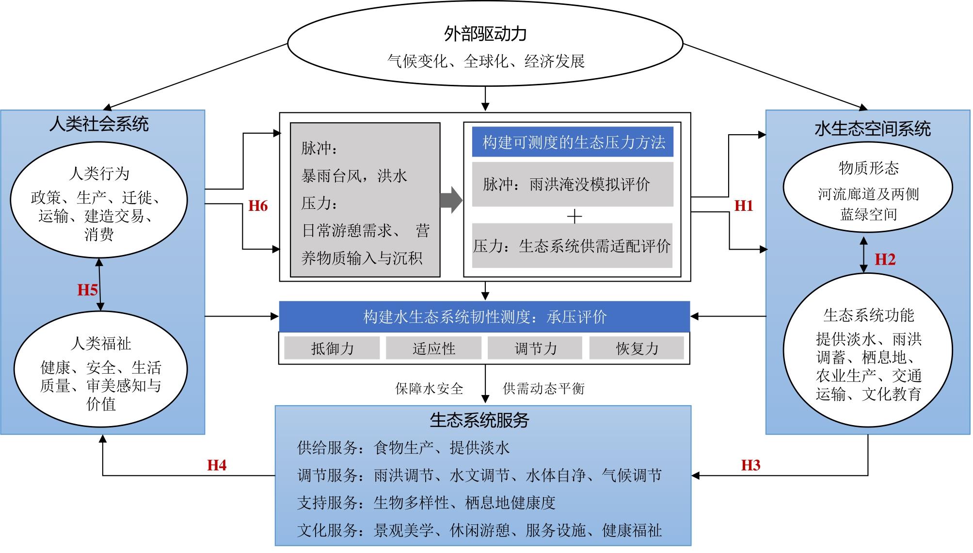
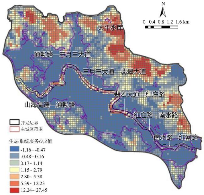
图1 基于水生态系统韧性的PPD评估模型 Fig.1 PPD assessment model based on water ecosystem resilience |
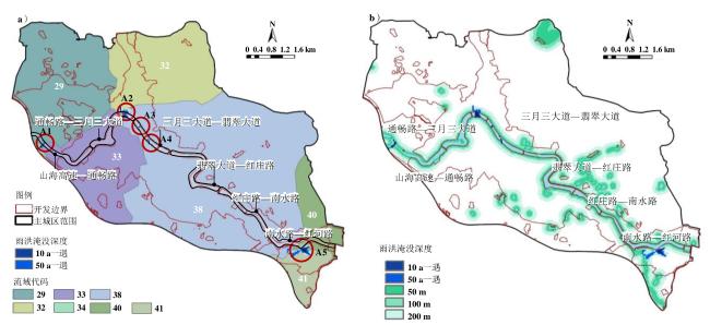
表1 各流域雨洪淹没高度统计Table 1 Stormwater inundation height statistics for each watershed |
| 测度因子 | 流域代码 | ||||||
|---|---|---|---|---|---|---|---|
| 29号 | 32号 | 33号 | 34号 | 38号 | 40号 | 41号 | |
| CN值 | 33.5 | 21.6 | 51.2 | 78.2 | 36.3 | 33.2 | 43.8 |
| 10 a一遇淹没高度/m | 253.8 | 307.6 | 303.3 | 264.5 | 305.7 | 318.5 | 318.3 |
| 50 a一遇淹没高度/m | 253.9 | 307.7 | 303.4 | 264.7 | 306.0 | 318.6 | 318.4 |
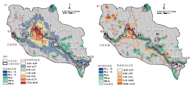
表2 基于热点与水安全的易受威胁区评级Table 2 Vulnerable zone ratings based on hotspots and water security |
| 区域分类 | 地块名称 | 雨洪淹没指数/水安全 | 人口热点 | 游憩热点 | 总分 |
|---|---|---|---|---|---|
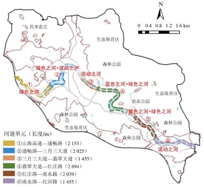
| 雨洪淹没风险区 | A1(山海高速—通畅路) | 5 | 1 | 1 | 7 |
| A2(通畅路—三月三大道) | 5 | 5 | 4 | 14 | |
| A3(三月三大道—翡翠大道) | 4 | 4 | 3 | 11 | |
| A4(三月三大道—翡翠大道) | 4 | 4 | 4 | 12 | |
| A5(南水路—红河路) | 5 | 2 | 2 | 9 | |
| 水安全易受威胁区 | B1(太平水库) | 5 | 2 | 4 | 11 |
| B2(什别河) | 4 | 2 | 4 | 10 | |
| B3(红庄路—南水路) | 3 | 1 | 4 | 8 |
|
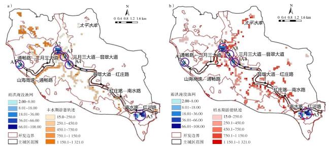
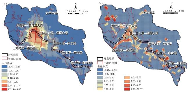
图7 游憩与雨洪淹没区叠合[a. 淡季(丰水期);b. 旺季(枯水期)] Fig.7 Recreation and stormwater floodplain overlay[a. off-season (period of high water level); b. peak season (period of low water level)] |
表3 南圣河蓝绿空间的生态系统服务价值当量 (元/hm2)Table 3 Equivalent value of ecosystem services of blue-green space of Nansheng River |
| 生态系统分类 | 供给服务 | 调节服务 | 支持服务 | 文化服务 | |||||||||||
|---|---|---|---|---|---|---|---|---|---|---|---|---|---|---|---|
| 一级 分类 | 二级分类 | 食物 生产 | 原料 生产 | 水资源 供给 | 气体 调节 | 气候 调节 | 净化 环境 | 水文 调节 | 土壤 保持 | 维持养分 循环 | 生物 多样性 | 美学景观 | |||
| 农田 | 旱地 | 0.79 | 0.37 | 0.02 | 0.62 | 0.33 | 0.09 | 0.25 | 0.96 | 0.11 | 0.12 | 0.06 | |||
| 水田 | 1.26 | 0.08 | 0.00 | 1.03 | 0.53 | 0.16 | 2.53 | 0.01 | 0.18 | 0.20 | 0.08 | ||||
| 森林 | 二级保护林地 | 0.50 | 1.42 | 0.59 | 6.11 | 18.28 | 5.17 | 7.02 | 7.44 | 0.44 | 6.76 | 1.82 | |||
| 三级保护林地 | 0.43 | 1.21 | 0.52 | 5.17 | 15.47 | 4.38 | 5.97 | 6.29 | 0.37 | 5.72 | 1.60 | ||||
| 四级保护林地 | 0.37 | 0.99 | 0.44 | 3.76 | 11.25 | 3.18 | 4.91 | 4.58 | 0.31 | 4.16 | 1.37 | ||||
| 乔木林地 | 0.31 | 0.71 | 0.37 | 2.35 | 7.03 | 1.99 | 3.51 | 2.86 | 0.22 | 2.60 | 1.14 | ||||
| 竹林地 | 0.22 | 0.52 | 0.27 | 1.70 | 5.07 | 1.49 | 3.34 | 2.06 | 0.16 | 1.88 | 0.82 | ||||
| 灌木林地 | 0.19 | 0.43 | 0.22 | 1.41 | 4.23 | 1.28 | 3.35 | 1.72 | 0.13 | 1.57 | 0.69 | ||||
| 其他林地 | 0.29 | 0.66 | 0.34 | 2.17 | 6.50 | 1.93 | 4.74 | 2.65 | 0.20 | 2.41 | 1.06 | ||||
| 草地 | 灌草丛 | 0.38 | 0.56 | 0.31 | 1.97 | 5.21 | 1.72 | 3.82 | 2.40 | 0.18 | 2.18 | 0.96 | |||
| 园地 | 园地 | 0.28 | 0.58 | 0.30 | 1.92 | 5.61 | 1.68 | 3.75 | 2.34 | 0.18 | 2.13 | 0.93 | |||
| 湿地 | 内陆滩涂 | 0.47 | 0.54 | 2.41 | 1.77 | 3.35 | 3.35 | 22.53 | 2.15 | 0.17 | 7.32 | 4.40 | |||
| 滩涂 | 0.47 | 0.54 | 2.41 | 1.77 | 3.35 | 3.35 | 22.53 | 2.15 | 0.17 | 7.32 | 4.40 | ||||
| 荒漠 | 裸土地 | 0.00 | 0.00 | 0.00 | 0.02 | 0.00 | 0.09 | 0.03 | 0.02 | 0.00 | 0.02 | 0.01 | |||
| 裸岩石砾地 | 0.01 | 0.03 | 0.02 | 0.01 | 0.09 | 0.29 | 0.20 | 0.12 | 0.01 | 0.11 | 0.05 | ||||
| 水域 | 水系 | 0.74 | 0.21 | 7.71 | 0.72 | 2.13 | 5.16 | 95.08 | 0.86 | 0.07 | 2.37 | 1.76 | |||
表4 城乡建设用地的生态系统服务矩阵Table 4 Ecosystem services matrix for urban and rural construction sites |
| 土地利用类型 | 支持 服务 | 非生物 异质性 | 生物 多样性 | 提供 淡水 | 生境 价值 | 调节 服务 | 气候 调节 | 空气质量调节 | 净化 水体 | 供给 服务 | 观赏 资源 | 遗传 资源 | 能源/ 生物量 | 文化 服务 | 美学 价值 | 游憩 旅游 | 文化 传承 |
|---|---|---|---|---|---|---|---|---|---|---|---|---|---|---|---|---|---|
| 城镇住宅用地(R) | 2 | 1 | 1 | 0 | 0 | 0 | 0 | 0 | 0 | 0 | 0 | 0 | 0 | 1 | 0 | 0 | 1 |
| 乡村建设用地(H14) | 5 | 2 | 2 | 0 | 1 | 0 | 0 | 0 | 0 | 3 | 1 | 1 | 1 | 4 | 1 | 1 | 2 |
| 公共管理与公共服务用地(A) | 3 | 1 | 1 | 0 | 1 | 2 | 1 | 1 | 0 | 1 | 0 | 1 | 0 | 6 | 1 | 2 | 3 |
| 商业服务设施用地(B) | 2 | 1 | 1 | 0 | 0 | 0 | 0 | 0 | 0 | 0 | 0 | 0 | 0 | 2 | 0 | 1 | 1 |
| 绿地(G1/G2) | 11 | 3 | 3 | 2 | 3 | 8 | 3 | 3 | 2 | 5 | 2 | 1 | 2 | 8 | 3 | 3 | 2 |
| 广场用地(G3) | 3 | 1 | 1 | 0 | 1 | 0 | 0 | 0 | 0 | 0 | 0 | 0 | 0 | 5 | 2 | 2 | 1 |
| 工业用地(M) | 2 | 1 | 1 | 0 | 0 | 0 | 0 | 0 | 0 | 2 | 0 | 0 | 2 | 1 | 0 | 0 | 1 |
| 道路与交通设施用地(S) | 5 | 2 | 2 | 0 | 1 | 0 | 0 | 0 | 0 | 2 | 1 | 0 | 1 | 4 | 1 | 2 | 1 |
|
表5 城市蓝绿空间水生态系统韧性指标Table 5 Indicators of water ecosystem resilience in urban blue-green spaces |
| 目标 | 准则层 | 指标 |
|---|---|---|
| 生态系统 服务能力 | 供给、支持、调节文化 的综合服务水平 | 土地利用类型 |
| 突发性脉冲 | 雨洪韧性 | 极端日降雨量 |
| 用地径流系数CN | ||
| 河流/水库植被缓冲带宽度 | ||
| 慢发性压力 (人类日常居住、 游憩需求) | 人口压力 | 人口密度 |
| 游憩压力 | 不同季候的游憩密度 |

1 http://wzs.hainan.gov.cn/wzsszfb/0500/202002/088a4c91f4454c2f9028bf516ac9e2e2.shtml
2 据五指山市气象局和Weather spark提供的1980-01-01―2016-12-31的历史小时天气报告统计。
3 需求分析来源于2020年的人口和游憩数据,人口数据来源于2020年worldpop(由南安普顿大学发起的全球人口数据评估)对五指山市人口空间分布的评估,精度为100 m分辨率的人口密度数据;游憩数据来源于2020年,通过PYTHON软件在两步路网站公开爬取2 600条与五指山市相关的游憩路径。
车 乐:确定论文选题、研究方法,提供数据支持,撰写摘要与主要结论、指导全文内容撰写;
李媛钰:撰写论文详细内容、进行数据处理与分析;
赵渺希:提出论文创新点、指导论文的写作规范性;
叶鸿任:搜集与整理文献、完善数据与图表内容。
|
Amy M Villamagna, Paul L Angermeier, and Elena M Bennett. 2013. Capacity, Pressure, Demand, and Flow: A Conceptual Framework for Analyzing Ecosystem Service Provision and Delivery. Ecological Complexity, (15): 114-121.https:/doi.org/10.1016/j.ecocom.
|
|
BIG 建筑事务所. 2017. 纽约下曼哈顿区弹性规划设计. 城市建筑,(12):80-85. [BIG Architects. 2017. Resilient Planning and Design for Lower Manhattan, New York. Urban Architecture, (12): 80-85. ]
|
|
Boughton W C. 1989. A Review of the USDA SCS Curve Number Method. Australian Journal of Soil Research, (3): 511-523.
|
|
陈昱霖,周连凤,王春芳,杨涵,梁友光,马沛明. 2020. 我国基于PSR模型水生态系统健康评价的研究进展//中国水利学会,黄河水利委员会. 中国水利学会2020学术年会论文集第一分册.北京:水利部中国科学院水工程生态研究所水生态监测中心,5.
Chen Yulin, Zhou Lianfeng, Wang Chunfang, Yang Han, Liang Youguang, and Ma Peiming. 2020. Research Progress of Water Ecosystem Health Assessment Based on PSR Model in China. In: China Water Resources Society and Yellow River Conservancy Commission. Proceedings of the 2020 Academic Annual Conference of the Chinese Water Resources Society, Branch 1. Beijing: Water Ecology Monitoring Center, Institute of Water Engineering and Ecology, Chinese Academy of Sciences, Ministry of Water Resources, 5. DOI:10.26914/c.cnkihy.2020.069702.
|
|
曹哲静. 2018. 荷兰空间规划中水治理思路的转变与管理体系探究. 国际城市规划,33(6):68-79.
Cao Zhejing. 2018. An Investigation into the Transformation of Water Governance Thinking and Management System in Spatial Planning in the Netherlands. International Urban Planning, 33(6): 68-79.
|
|
陈宗铸,雷金睿,吴庭天,陈德祥,周璋,李苑菱,洪小江,杨众养,李意德. 2021. 国家公园生态系统生产总值核算——以海南热带雨林国家公园为例. 应用生态学报,32(11):3883-3892.
Chen Zongzhu, Lei Jinrui, Wu Tingtian, Chen Dexiang, Zhou Zhang, Li Yuanling, Hong Xiaojiang, Yang Zongyang, and Li Yide. 2021. Accounting for Gross Ecosystem Product in National Parks: A Case Study of Hainan Tropical Rainforest National Park. Journal of Applied Ecology, 32(11): 3883-3892.
|
|
Colins S L, Carpenter S R, Swinton S W, Orenstein D E, and Childers D L. 2011. An Integrated Conceptual Framework for Long-Term Social-Ecological Research. Front Ecological Environment, (6): 351-357.
|
|
Evelyn H, Hamilton and Sybille Haeussler. 2008. Modeling Stability and Resilience after Slashburning across a Sub-boreal to Subalpine Forest Gradient in British Columbia. Canadian Journal of Forest Research, 38(2): 304-316. DOI:10.1139/X07-098.
|
|
韩用顺,王文娟,张东水,李爱国,王仁超,常禹龙. 2022. 一种基于分区和识别真实居住区的人口空间化方法——以雅砻江流域为例. 山地学报,40(2):303-316.
Han Yongshun, Wang Wenjuan, Zhang Dongshui, Li Aiguo, Wang Renchao, and Chang Yulong. 2022. A population Spatialization Method Based on Zoning and Identification of Real Settlements: A Case Study of Yalong River Basin. Mountain Journal, 40(2): 303-316.
|
|
Holling C S. 1973. Resilience and Stability of Ecological Systems. Annual Review of Ecology and Systematics, 4(4): 1-23.
|
|
侯鹏,翟俊,曹巍,杨旻,蔡明勇,李静. 2018. 国家重点生态功能区生态状况变化与保护成效评估——以海南岛中部山区国家重点生态功能区为例. 地理学报,73(3):429-441.
Hou Peng, Zhai Jun, Cao Wei, Yang Min, Cai Mingyong, and Li Jing. 2018. Changes in Ecological Status and Assessment of Protection Effectiveness of National Key Ecological Functional Areas - A Case Study of National Key Ecological Functional Areas in the Central Mountainous Area of Hainan Island. Journal of Geography, 73(3): 429-441.
|
|
胡岳.2016. 韧性城市视角下城市水系统规划应用与研究//中国城市规划学会,沈阳市人民政府. 规划60年:成就与挑战——2016中国城市规划年会论文集(01城市安全与防灾规划). 深圳:深圳市城市规划设计研究院有限公司,9.
Hu Yue. 2016. Application and Research on Urban Water System Planning under the Perspective of Tough City. In: China Society of Urban Planning and Shenyang Municipal People's Government. 60 Years of Planning:Achievements and Challenges-Proceedings of the 2016 Annual Conference on Urban Planning in China (01 Urban Safety and Disaster Prevention Planning). Shenzhen: Shenzhen Urban Planning and Design Institute Limited, 9.
|
|
黄铎,易芳蓉,汪思哲,韦慧杰,王世福. 2022. 国土空间规划中蓝绿空间模式与指标体系研究. 城市规划,46(1):18-31.
Huang Duo, Yi Fangrong, Wang Sizhe, Wei Huijie, and Wang Shifu. 2022. Research on Blue-Green Spatial Model and Indicator System in Territorial Spatial Planning. Urban Planning, 46(1): 18-31.
|
|
纪然,丁金华. 2019. 基于水生态系统服务供需关系的苏南乡村空间形态重构. 规划师,35(20):5-12.
Ji Ran and Ding Jinhua. 2019. Reconstruction of Rural Spatial Patterns in Southern Jiangsu Based on Supply and Demand of Water Ecosystem Services. Planner, 35(20): 5-12.
|
|
贾绿媛. 2021. 韧性城市理论下的河流蓝绿网络构建策略研究——以永定河北京城市段为例//中国城市规划学会,成都市人民政府.面向高质量发展的空间治理——2021中国城市规划年会论文集(07城市设计). 北京:北京林业大学,601-611.
Jia Lvyuan. 2021. Research on the Construction Strategy of River Blue-Green Network under the Theory of Tough City: Taking the Urban Section of Yongding River in Beijing as an Example. In: Chinese Society of Urban Planning and Chengdu Municipal People's Government. Spatial Governance for High Quality Development-Proceedings of the 2021 China Annu Conference on Urban Planning (07 Urban Design). Beijing: Beijing Forestry University, 601-611. DOI:10.26914/c.cnkihy.2021.026544.
|
|
姜超,谭珂,任明迅. 2017. 季风对亚洲热带植物分布格局的影响. 植物生态学报,41(10):1103-1112.
Jiang Chao, Tan Ke, and Ren Mingxun. 2017. Effects of Monsoon on the Distribution Pattern of Tropical Plants in Asia. Journal of Plant Ecology, 41(10): 1103-1112.
|
|
李霖明. 2022. 海南热带雨林国家公园景观格局及生态系统服务价值时空变化分析. 海南:海南大学.
Li Linming. 2022. Analysis of Spatial and Temporal Changes in Landscape Pattern and Ecosystem Service Value in Hainan Tropical Rainforest National Park. Hainan: Hainan University. DOI:10.27073/d.cnki.ghadu.2022.000151.
|
|
李莎莎,翟国方,吴云清. 2011. 英国城市洪水风险管理的基本经验.国际城市规划,(4):36-40.
Li Shasha, Zhai Guofang, and Wu Yunqing. 2011. Basic Experience of Urban Flood Risk Management in the UK. International Urban Planning, (4): 36-40.
|
|
廖桂贤,林贺佳,汪洋.2015. 城市韧性承洪理论——另一种规划实践的基础.国际城市规划,(2):36-47.
Liao Guixian, Lin Hejia, and Wang Yang. 2015. Urban Resilience Flood Theory: An Alternative Basis for Planning Practice. International Urban Planning, (2): 36-47.
|
|
罗日洪,黄锦林,王立华. 2017. 海南省五指山市山洪灾害分析评价. 广东水利水电,(7):34-39.
Luo Rihong, Huang Jinlin, and Wang Lihua. 2017. Analysis and Evaluation of Flash Flood Disaster in Wuzhishan City, Hainan Province. Guangdong Water Conservancy and Hydropower, (7): 34-39.
|
|
李彤玥. 2017. 韧性城市研究新进展. 国际城市规划,32(5):15-25. [Li Tongyue. 2017. New Advances in Tough City Research. International Urban Planning, 32(5): 15-25. ]
|
|
马勇,凌旋,童昀. 2021. 格网尺度下典型旅游城市生态服务价值估算和时空分异特征——以三亚为例. 生态学报,41(19):7542-7554.
Ma Yong, Ling Xuan, and Tong Yun. 2021. Estimation of Ecological Service Value and Spatio-Temporal Differentiation Characteristics of Typical Tourist Cities at Grid Scale: Taking Sanya as an Example. Journal of Ecology, 41(19): 7542-7554.
|
|
Oliveira-Junior N, Heringer G, Bueno M L, Pontara V, and Meira-Neto J. 2020. Prioritizing Landscape Connectivity of a Tropical Forest Biodiversity Hotspot in Global Change Scenario. Forest Ecology and Management, 472: 118247.
|
|
Paetzold A, Warren P H, and Maltby L L. 2010. A Framework for Assessing Ecological Quality Based on Ecosystem Services. Ecological Complexity, 7(3): 273-281.
|
|
彭建,李冰,董建权. 2020. 论国土空间生态修复基本逻辑.中国土地科学,34(5):18-26.
Peng Jian, Li Bing, and Dong Jianquan. 2020. On the Basic Logic of Ecological Restoration of Land Space. China Land Science, 34(5): 18-26.
|
|
Rapport D J and Singh A. 2006. An EcoHealth-based framework for State of Environment Reporting. Ecological Indicators, 6(2): 409-428.
|
|
Spaans M and Waterhout B. 2017. Building up Resilience in Cities Worldwide-Rotterdam as Participant in the 100 Resilient Cities Programme. Cities, 61: 109-116.
|
|
Vis M, Klijn F, De Bruijn K M, and Van Buuren M. 2003. Resilience Strategies for Flood Risk Management in the Netherlands. International Journal of River Basin Management, (1): 33-40.
|
|
王敏,侯晓晖,汪洁琼. 2018. 基于传统生态智慧的江南水网空间韧性机制及实践启示. 风景园林,25(6):52-57.
Wang Min, Hou Xiaohui, and Wang Jieqiong. 2018. Spatial Resilience Mechanism of Jiangnan Water Network Based on Traditional Ecological Wisdom and Practical Insights. Landscape Architecture, 25(6): 52-57. DOI:10.14085/j.fjyl.2018.06.0052.06.
|
|
吴挺勋,姚小兰,任明迅. 2022. 海南热带雨林国家公园道路分布及其对景观完整性的影响. 热带生物学报,13(2):101-111.
Wu Tingxun, Yao Xiaolan, and Ren Mingxun. 2022. Distribution of Roads and Their Impact on Landscape Integrity in Hainan Tropical Rainforest National Park. Journal of Tropical Biology, 13(2): 101-111. DOI:10.15886/j.cnki.rdswxb.2022.02.001.
|
|
谢高地,张彩霞,张雷明,陈文辉,李士美. 2015. 基于单位面积价值当量因子的生态系统服务价值化方法改进. 自然资源学报,30(8):1243-1254.
Xie Gaodi, Zhang Caixia, Zhang Leiming, Chen Wenhui, and Li Shimei. 2015. Improvement of the Evaluation Method for Ecosystem Service Value Based on Per Unit Area. Journal of Natural Resources, 30(8): 1243-1254.
|
|
闫水玉,唐俊. 2022. 城市绿色空间生态系统服务供需匹配评估方法:研究进展与启示. 城市规划学刊,(2):62-68.
Yan Shuiyu and Tang Jun. 2022. Assessment Methods for Matching Supply and Demand of Ecosystem Services in Urban Green Space: Research Progress and Insights. Journal of Urban Planning, (2): 62-68. DOI:10.16361/j.upf.202202009.
|
|
余俏,杜梦娇,李昊宸,汤西子,李晓燕. 2022. 通向城乡韧性的蓝绿空间整体规划研究:概念框架与实现路径. 资源与生态学报(英文版),13(3):347-359.
Yu Qiao, Du Mengjiao, Li Haochen, Tang Xizi, and Li Xiaoyan. 2022. Holistic Planning of Blue-Green Space towards Urban-Rural Resilience: Conceptual Framework and Realization Path. Journal of Resources and Ecology (English Edition), 13(3): 347-359. DOI:10.5814/j.issn.1674-764x.2022.03.001.
|
|
俞孔坚,李迪华.2003. 城市景观之路:与市长们交流.北京:中国建筑工业出版社.
Yu Kongjian and Li Dihua. 2003. The Road to Urban Landscape: Communication with Mayors. Beijing: China Architecture Industry Press.
|
|
张岩. 2021. 基于生态系统服务的防洪供需评估与情景预测. 南京:南京大学.
Zhang Yan. 2021. Ecosystem Service-Based Supply and Demand Assessment and Scenario Prediction for Flood Control. Nanjing: Nanjing University. DOI:10.27235/d.cnki.gnjiu.2021.000261.
|
|
周可婧. 2021. 基于生态系统服务供需的城市流域雨洪安全格局构建研究. 长沙:湖南大学.
Zhou Kejing. 2021. A Study on Constructing Stormwater Safety Patterns in Urban Watersheds Based on the Supply and Demand of Ecosystem Services. Changsha: Hunan University. DOI:10.27135/d.cnki.ghudu.00094.
|
|
庄智程,李成,顾思浩,韩雪琦,侯欣杉. 2022. 基于CiteSpace的生态系统服务供需关系研究进展与热点分析.生态科学,41(4):212-222.
Zhuang Zhicheng, Li Cheng, Gu Sihao, Han Xueqi, and Hou Xinshan. 2022. Progress and Hotspot Analysis of CiteSpace-Based Research on Ecosystem Service Supply-Demand Relationship. Ecological Science, 41(4): 212-222.
|
/
| 〈 |
|
〉 |
