
基于SWOT的中缅印度洋通道瑞丽与孟定清水河对比研究
|
李如英(1976—),女,云南大理人,副教授,研究方向为党的建设、三农问题,(E-mail)2918088692@qq.com; |
收稿日期: 2023-06-27
修回日期: 2024-01-28
网络出版日期: 2024-07-08
基金资助
国家社会科学基金重大项目“大数据时代地缘环境解析的理论与方法跨学科研究”(20&ZD138)
国家自然科学基金项目“多元地缘体双层博弈下东北亚地缘环境演变及其驱动机制研究”(42371230)
北师大博士生学科交叉基金项目“中缅印度洋新通道建设与缅甸地缘环境变化研究”(Grant BNUXKJC2204)
Comparative Study of the Ruili and Mengding Qingshui Rivers in the China-Myanmar Indian Ocean Corridor Based on SWOT
Received date: 2023-06-27
Revised date: 2024-01-28
Online published: 2024-07-08
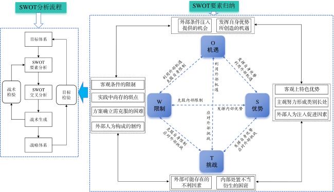
瑞丽出境的中缅“人字形”经济走廊(简称“人字形”走廊)与孟定清水河出境的中缅印度洋新通道(简称“新通道”)建设与发展上的极大反差引起学界广泛关注。鉴于此,搭建SWOT的国际通道分析理论与框架,对“人字形”走廊与新通道的差异部分(即瑞丽—腊戌与孟定清水河—腊戌)进行SWOT要素阐述和关键影响因素的对比分析,以揭示二者的比较优势与不同时期侧重选择的地理逻辑。研究表明:1)不同时空序列下中缅印度洋通道建设的关键影响因素存在显著差别。历史域上的关键影响因素有明显的“地理决定论意味”,以地形、高程、河流、地质等为代表的自然地理环境与特征深刻影响着早期的中缅通道建设;现实域层面的关键影响因素多为“人类主观能动性的发挥程度和科技进步是否促生通道建设“时空压缩”,即主观能动性和科技进步等能否缩短通道的建设里程和关键路段建设工期、是否能提升与城市群关联度和完善运输网络体系等;未来域的关键影响因素则是关注通道的“成长”、国家话语支持和战略定位以及服务国家的长效机制等方面,最直接的便是国家对通道的定位、赋能及话语政策支持等。2)瑞丽与孟定清水河作为中缅印度洋通道的中方出境口岸,其选址在不同时期侧重不同地理考量,受到各自S、W、O、T主导要素的裹挟影响与约束。瑞丽(“人字形”走廊)为抗争战略调整型,孟定清水河(新通道)为抗争战略进取型。3)总体上孟定清水河至腊戌一线(新通道)相较瑞丽至腊戌一线(“人字形”走廊)的优势和潜力较为明显,阻碍和困难相对较小,佐证了“优势在孟”的新通道方案。“人字形”走廊与新通道具有明显的互补性特征,传递出双“Y”轴通道设想的科学性与可行性。

李如英 , 牛福长 , 胡志丁 , 赵正贤 . 基于SWOT的中缅印度洋通道瑞丽与孟定清水河对比研究[J]. 热带地理, 2024 , 44(7) : 1171 -1183 . DOI: 10.13284/j.cnki.rddl.20230500
The construction of the China-Myanmar Economic Corridor (CMEC) out of Ruili and the China-Myanmar Indian Ocean New Corridor (CMIONC) out of Qingshuihe in Mengding has attracted much attention. The great contrast between the construction and development of the CMEC and the CMIONC has raised widespread concern in the academic community. Therefore, we developed a theory and framework of international corridor analysis based on the SWOT (Strengths, Weaknesses, Opportunities, and Threats), and conducted a comparative analysis of SWOT elements and key influencing factors between the CMEC and CMIONC (Ruili-Lashu and Mengding-Qingshuihe-Lashu) to reveal the differences between them and the key influencing factors of the CMIONC. We evaluated the comparative advantages of the CMEC and CMIONC and the geographic logic of focusing on various choices at different times. The study produced several important results: (1) There are significant differences in the key factors influencing the construction of the China-Myanmar Indian Ocean Corridor in different spatial and temporal sequences. The key influencing factors in the historical domain have obvious geographic determinism, and the natural geographic environment and features represented by topography, elevation, rivers, geology, among others., profoundly influenced the construction of the China-Myanmar corridor in the early period. The key influencing factors in the actual domain are mostly the degree of human initiative and the degree of scientific and technological progress contributing to the construction of the corridor and the extent to which the corridor will be constructed. Whether the progress of science and technology can contribute to the "space-time compression" of the corridor construction is to be determined. Whether the subjective initiative and progress of science and technology can shorten the construction distance of the corridor and the construction period of key sections and whether it can enhance the degree of connection with the urban agglomerations and improve the transport network system should be analyzed. Furthermore, the key influencing factors in the future domain will be the growth and national discourse support of the corridor. These aspects include strategic positioning and long-term mechanisms to serve the country, the most direct national positioning of the channel, empowerment, and discourse policy support, and others. (2) Ruili and Qingshuihe of Mengding, as the Chinese exit ports of the China-Myanmar Indian Ocean Corridor, have focused on different geographic considerations at different times and have been subject to the influences and constraints of the dominant SWOT elements. Ruili (the "herringbone" corridor) is a type of resistance strategy adjustment, and the Mengding Qingshui River (new corridor) is a type of resistance strategy aggressiveness. (3) On the whole, the advantages and potentials of the line from the Mengding Qingshuihe River to Laxun (the new corridor) are more evident than those of the line from Ruili to Laxun ("herringbone" corridor), and the obstacles and difficulties are relatively small, which proves that the advantages are in Meng for the new corridor program. The "herringbone" corridor and the new corridor have prominent complementary characteristics, highlighting the scientific soundness and feasibility of the double "Y" axis corridor concept.
表1 不同时期滇缅铁路的选址Table1 Site selection of Yunnan-Myanmar Railway in different periods |
| 时期 | 基本走向 | 出境选址之争及当时的倾向 |
|---|---|---|
| 晚清时期 | 共提出4条方案路线,当时的基本趋向是选择毗邻瑞丽的第二 方案路线:八莫线 | 未有选址经瑞丽进入云南的路线,相反在第四条巴格莱线(戴维斯线),明确选定云南孟定作为出境点 |
| 民国初年 | 《建国方略》提出7条路线方案,最终确定南线 | 南线即:昆明至祥云清华洞,经弥渡、南涧、云县、沿着南定河经滚弄跨萨尔温江至腊戎接缅甸铁路,倾向于孟定 |
| 抗日战争时期 | 东起昆明,西经安宁、平浪、禄丰、广通、楚雄、姚安、祥云、弥渡、 南涧、云县、耿马等县,拟连通缅甸密支那铁路线上的腊戌站 | 将临沧孟定编译为滇缅铁路的最佳出境,未有涵盖瑞丽的线路 |
表2 瑞丽至腊戌一线与清水河至腊戌一线SWOT要素列举Table 2 SWOT analysis of Ruili to Lashu line and Qingshuihe to Lashu line |
| 轴向 | 瑞丽至腊戌一线 | 孟定清水河至腊戌一线 |
|---|---|---|
| S | 国家一类口岸,中缅边境口岸中人员、车辆、货物流量最大的口岸;对第三国开放;享受沿边经济开发区政策;最完备口岸现代化管理功能的综合性联检查验中心;昆瑞公路与缅甸的“史迪威”公路相接点;建有铁路、机场航空和千吨级轮船沿伊洛瓦底江直达曼德勒和仰光,境外段公路、铁路、航空、水运等基础设施整合程度较高; 内地居民因私经瑞丽首次出境,在未有外国驻华使馆中办理签证无限制。 | 国家一类口岸;历史上铁路规划的选点多倾向于清水河;清水河通道到腊戌或曼德勒的地理距离较近,沿途大多是地势平坦的河谷坝区,避开横断山区、高黎贡山等山脉且地质条件偏好,铁路里程最短、施工最便捷、建设成本最低、建设周期最佳(彭永岸 等,1995)。 |
| W | 大瑞铁路仍处于建设阶段工期极不确定; 境外关键路段地理距离较远; 瑞丽到腊戌或曼德勒的地理距离较远,地质条件极差; 瑞丽与连接腹地较远,瑞丽位置偏西,区位相对偏僻。 | 经历云南省二类开放口岸到国务院批准一类对外开放口岸的漫长历程;未对第三国开放; 口岸规模、配套基础设施较瑞丽较差; 腹地城市支撑较弱,为孟定镇、耿马县、临沧市。 |
| O | 国家对口岸的定位与铁路对口岸的赋能,瑞丽同时被列入“重点枢纽口岸示范工程”“口岸补短板工程”(重要边境口岸“卡脖子”事项解决工程)“口岸国际合作工程”(毗邻国家口岸补短板工程); 木姐—瑞丽跨境经济合作区支撑;腹地级别较高为瑞丽市; 国家战略与话语主导明显,中印孟缅经济走廊—中缅人字形备忘录等国家权力和话语支撑。 | 未来中缅印度洋新通道将获得相关省级和国家级话语。 “新通道建设和效益成长迅速,潜力凸显;3种跨境电商模式早于瑞丽,9810模式在全省领先;从临沧入缅甸,清水河口岸已具备“9610”(企业对个人B2C出口)、“9710”(跨境电商B2B直接出口)和“9810”(跨境电商出口海外仓)3种模式的跨境电商通关。 |
| T | 瑞丽—腊戌段是缅北冲突最频发的一线,冲突涉及到类型最为复杂,牵涉到利益主体较为多元,沿途需要分别经过德昂民族解放军、克钦独立军(KIA)、缅甸民族民主联盟军的“驻地”或势力范围区;缅民盟的多元平衡及默许缅民间的大肆“反华”社会活动和情绪表达等(Brenner, 2018);与畹町等口岸竞争激烈,市场威胁较大和存在被替代风险;瑞丽—腊戌段铁路开展工程可行性前期研究,但尚未进入线路实际规划阶段。 | 没有获得国家、省级政府应有的足够重视;学界、智库等对临沧的研究关注较少,学术支撑、建设宣传的论证不如瑞丽;清水河—腊戌段现代化铁路尚未启动规划研究。 |
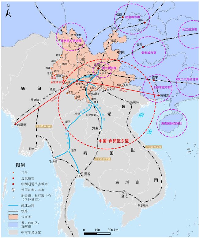
图4 双“Y”型中缅印度洋通道新构想示意 Fig.4 New concept of double "Y"-shaped China-Myanmar Indian Ocean Passage |

1 https://www.chinanews.com.cn/cj/2022/08-19/9831924.shtm
2 https://baike.steelhome.cn/doc-view-10479.html
3 https://news.cctv.com/2017/11/20/ARTI4cl7hSQRbdPBvwRex4rF171120.shtml
4 https://www.chinanews.com.cn/cj/2022/08-19/9831924.shtml
5 战略地位重要、口岸经济社会效益强和辐射带动作用大的口岸作为国际枢纽口岸;战略地位比较重要、口岸经济社会效益较强和辐射带动作用较大的口岸作为国家重要口岸;其他口岸作为地区普通口岸。
李如英:论文设计、案例调研、经费支持;
牛福长:论文撰写、修改、校稿、核对;
胡志丁:案例调研与经费支持;
赵正贤:数据整理与制图。
|
Athukorala P and Narayanan S. 2018. Economic Corridors and Regional Development: The Malaysian Experience. World Development, 106: 1-14.
|
|
陈发虎,安成邦,董广辉,张东菊. 2017. 丝绸之路与泛第三极地区人类活动、环境变化和丝路文明兴衰. 中国科学院院刊,32(9):967-975.
Chen Fahu, An Chengbang, Dong Guanghui, and Zhang Dongju. 2017. Human Activities, Environmental Changes, and Rise and Decline of Silk Road Civilization in Pan-Third Pole Region. Bulletin of Chinese Academy of Sciences, 32(9): 967-975.
|
|
戴超武. 2016. 中缅边界问题与尼赫鲁的干预及其战略意图(1956—1960). 中共党史研究,(11):53-69. [Dai Chaowu. 2016. Nehru's Strategic Goal to Intervene in China-Burma Boundary Issues, 1956—1960. CPC History Studies, (11): 53-69. ]
|
|
董锁成,杨洋,李富佳,程昊,李静楠. 2019. 中蒙俄高铁建设的影响机理及对策. 地理学报,74(2):297-311.
Dong Suocheng, Yang Yang, Li Fujia, Cheng Hao, and Li Jingnan. 2019. Influencing Mechanism and Policy Suggestions of China Mongolia-Russia High-Speed Railway Constructi. Acta Geographica Sinica, 74(2): 297-311.
|
|
范宏伟. 2008. 中缅关系的转折:1954年—以外交部解密档案为视角. 东南亚研究,(5):90-94.
Fan Hongwei. 2008. The Shift of Sino-Burma Relations in 1954: Perspective from the Declassified Documents of China's Ministry of Foreign Affairs. Southeast Asian Studies,(5): 90-94.
|
|
洪菊花,骆华松. 2020. 区域合作与地缘安全复合系统结构与功能研究——以澜湄合作与孟中印缅经济走廊对比分析为例. 云南地理环境研究,32(2):1-7,27.
Hong Juhua and Luo Huasong. 2020. Study on the Structure and Function of Regional Coopration and Geo-Security Composite System: A Comparative Analysis of LMS and BCIM Economic Corridor. Yunnan Geographic Environment Research, 32(2): 1-7, 27.
|
|
胡娟,何咏洁. 2021. 后新冠疫情时代中国开拓印度洋出海大通道的机遇与挑战. 南亚东南亚研究,53(1):75-91,153-154.
Hu Juan and He Yongjie. 2021. Opportunities and Challenges for China's Opening to the Indian Ocean Rim in the Post-Coronavirus Era. South and Southeast Asian Studies, 53(1): 75-91, 153-154.
|
|
Hu Zhiding and Lu Dadao. 2016. Re-Interpretation of the Classical Geopolitical Theories in a Critical Geopolitical Perspective. Journal of Geographical Sciences, 26(12): 1769-1784.
|
|
临沧市商务局. 2020. 孟定清水河口岸成为全省第二大对缅贸易口岸. (2022-07-22)[2023-06-15]. https://www.lincang.gov.cn/info/1479/32065.htm. [Lincang Municipal Bureau of Commerce. 2020. Qingshuihe Port in Mengding Became the Second Largest Trade Port with Myanmar in the Province. (2022-07-22) [2023-06-15]. https://www. lincang. gov. cn/info/1479/32065.htm.
|
|
Lakshmanan T R. 2011. The Broader Economic Consequences of Transport Infrastructure Investments. Journal of Transport Geography, 19(1): 1-12.
|
|
雷洋. 2021. 时空演进视角下中巴伊土国际运输通道效能评估. 重庆:重庆交通大学.
Lei Yang. 2021. Effectiveness Evaluation of the China-Pakistan-Iran-Turkey International Transport Corridor from the Perspective of Temporal and Spatial Evolution. Chongqing: Chongqing Jiaotong University.
|
|
Lesutis G. 2020. How to Understand a Development Corridor? The Case of Lamu Port-South Sudan-Ethiopia-Transport Corridor in Kenya. Area, 52(3): 600-608.
|
|
李华,周溪召,智路平. 2015. 河口海港型城市邮轮经济发展研究——以南京为例.世界地理研究,24(1):113-122.
Li Hua, Zhou Xizhao, and Zhi Luping. 2015. Study on cruise Economy Development of Estuarine Harbor City. World Regional Studies, 24(1): 113-122.
|
|
李灿松,胡平平,杨旺舟. 2019. 缅北局势及其对中缅经济走廊建设的影响. 热带地理,39(6):823-832.
Li Cansong, Hu Pingping, and Yang Wangzhou. 2019. Impact of the northern Myanmar Situation on the China-Myanmar Economic Corridor Construction. Tropical geography, 39(6): 823-832.
|
|
李晨阳. 2019. 滇缅铁路的前世今生. 世界知识,(10):73. [Li Chenyang. 2019. The Past Life of Burma Railway. World Affairs, (10): 73. ]
|
|
李鲁奇,吴启焰,刘可文,梁双波,钱超峰. 2020. 历史视角下亚欧大陆海陆交通可达性空间格局演化. 地理学报,75(4):804-819 .
Li Luqi, Wu Qiyan, Liu Kewen, Liang Shuangbo, and Qian Chaofeng. 2020. Spatial Evolution of Eurasian Land and Sea Transport Accessibility from the Historical Perspective. Acta Geographica Sinica, 75(4): 804-819.
|
|
李勤,陈旭. 2008. 云南国际大通道对第三亚欧大陆桥的推进作用研究. 经济问题探索. (1):7-10.
Li Qin and Chen Xu. 2008. Research on the Promoting Effect of Yunnan International Passage on the Third Eurasian Land Bridge. Inquiry into Economic Issues, (1): 7-10.
|
|
梁洪. 1997. 开辟面向印度洋的出海通道. 中国水运,(8):34.
Liang Hong. 1997. Open up a Sea Passage Facing the Indian Ocean. China Water Transport,(8): 34.
|
|
卢光盛,邓涵. 2015. 经济走廊的理论溯源及其对孟中印缅经济走廊建设的启示. 南亚研究,(2):1-14,154.
Lu Guangsheng and Deng Han. 2015. The Theoretical Building Blocks of Economic Corridors and Implications for the Development of the BCIM Economic Corridor. South Asian Studies, (2): 1-14, 154.
|
|
陆梦秋,陈娱,陆玉麒. 2018. “一带一路”倡议下中国陆海运输的空间竞合格局. 地理研究,37(2):404-418.
Lu Mengqiu, Chen Yu, and Lu Yuqi. 2018. The Competition and Cooperation Spatial Pattern between Railway Transport and Shipping in China under the Belt and Road Initiative. Geographical Research, 37(2): 404-418.
|
|
罗群. 1997. 滇缅铁路的历史构想及现实意义. 思想战线,(6):29-34.
Luo Qun. 1997. The Historical Conception and Practical Significance of Burma Railway. Thinking, (6): 29-34.
|
|
McCartney M. 2022. The China-Pakistan Economic Corridor (CPEC): Infrastructure, Social Savings, Spillovers, and Economic Growth in Pakistan. Eurasian Geography and Economics, 63(2): 180-211.
|
|
Murton G and Lord A. 2020. Trans-Himalayan Power Corridors: Infrastructural Politics and China's Belt and Road Initiative in Nepal. Political Geography, 77(C): 102100.
|
|
迈克尔·波特. 2014. 竞争战略. 陈丽芳. 译. 北京:中信出版社.
Michael Porter. 2014. Competitive Strategy. Chen Lifang. Translation. Beijing: CITIC Publishing House.
|
|
Noorali H and Ahmadi S. 2022. Iran's New Geopolitics: Heartland of the World's Corridors. GeoJournal, 88: 1889-1904.
|
|
Padraing Belton. 2020. 竞争战略 分析产业和竞争对手的技术. 陶庆. 译. 上海:上海外语教育出版社,5-6.
Padraing Belton. 2020. Competitive Strategy Analysis Industry and Competitor's Technology. Tao Qin. Translation. Shanghai: Shanghai Foreign Language Education Press.
|
|
彭永岸,王云鹏. 1995. 主目标分析法对中缅铁路走向进行抉择. 热带地理,15(3):193-201.
Peng Yongan and Wang Yunpeng. 1995. Main Object Analysisi of the Run of China-Myanmar Raiway. Tropical Geography, 15(3): 193-201.
|
|
荣朝和. 1995. 论交通运输在经济时空推移和结构演变中的宏观作用. 地理学报,50(5):394-401.
Rong Chaohe. 1995. A Macro Effect of Transport in the Change of Economic Spatial Structure. Acta Geographica Sinica, 50(5): 394-401.
|
|
宋大伟,赵璐,沈熙,张凤,王光辉,刘昌新,朱永彬. 2022. 中缅印度洋新通道建设战略研究——运用双螺旋法谋划海公铁跨境多式联运. 中国科学院院刊,37(11):1595-1601.
Song Dawei, Zhao Lu, Shen Xi, Zhang Feng, Wang Guanghui, and Zhu Yongbin. 2022. Research on the Strategy of China-Myanmar-Indian Ocean New Channel—Application of Think Tank Double Helix Methodology in Planning Cross-Border Multimodal transportation of Ocean Shipping, Highway and Railway. Bulletin of Chinese Academy of Sciences, 37(11): 1595-1601.
|
|
宋周莺,姚秋蕙,胡志丁,刘卫东. 2020. 跨境经济合作区建设的“尺度困境”——以中老磨憨-磨丁经济合作区为例. 地理研究,39(12):2705-2717.
Song Zhouying, Yao Qiuhui, Hu Zhiding, and Liu Weidong. 2020. 'Scale Paradox' of Cross-Border Economic Cooperation Zones:A Case Study of China-Laos Mohan-Boten Economic Cooperation Zone. Acta Geographica Sinica, 39(12): 2705-2717.
|
|
Su X. 2013. From Frontier to Bridgehead: Cross-Border Regions and the Experience of Yunnan, China: From Peripheral Frontier to Economic Bridgehead: The Case of Yunnan. International Journal of Urban and Regional Research, 37(4): 1213-1232.
|
|
Su X and Lim K F. 2022. Capital Accumulation, Territoriality, and the Reproduction of State Sovereignty in China: Is This "New" State Capitalism? Environment and Planning A: Economy and Space, 308-518.
|
|
司徒尚纪,许桂灵. 2015. 中国海上丝绸之路的历史演变. 热带地理,35(5):628-636.
Situ Shangji and Xu Guiling. 2015. Historical Evolution of China's Maritime Silk Road. Tropical Geography, 35(5): 628-636.
|
|
Thomas K. 2021. International Rivers as Border Infrastructures: En/Forcing Borders in South Asia. Political Geography, 89: 102448.
|
|
吴良,秦奇,张丹,成升魁. 2018. 印度洋通道及其对中国地缘环境影响. 地理科学进展,37(11):1510-1520.
Wu Liang, Qin Qi, Zhang Dan, and Cheng Shengkui. 2018. Indian Ocean Passages and Their Geopolitical Impacts on China. Progress in Geography, 37(11): 1510-1520.
|
|
杨祥章,郑永年. 2019. “一带一路”框架下的国际陆海贸易新通道建设初探. 南洋问题研究,(1):11-21.
Yang Xiangzhang and Zheng Yongnian. 2019. Study on the Construction of the International Land and Maritime Trade Corridor in the Belt and Road Framework. Southeast Asian Affairs, (1): 11-21.
|
|
杨在月,胡志丁,惠凯,马晓东,王博. 2017. 论地缘战略区位的主体间性——以缅甸为例. 世界地理研究,26(2):1-10.
Yang Zaiyue, Hu Zhiding, Hui Kai, Ma Xiaodong, and Wang Bo. 2017. Study on the Inter-Subjectivity of Geopolitical Strategy Location—Taking Myanmar as an Example. World Regional Studies, 26(2): 1-10.
|
|
袁牧,张晓光,杨明. 2007. SWOT分析在城市战略规划中的应用和创新. 城市规划,(4):53-58.
Yuan Mu, Zhang Xiaoguang, and Yang Ming. 2022. SWOT Analysis in Urban Strategic Planning: Application and Innovation. City Planning Review, (4):53-58.
|
|
云南省交通运输厅. 2022. 云南云南省铁路“十四五”发展规划(2022-01-14)[2022-05-16]. https://www.yn.gov.cn/ztgg/ynghgkzl/sjqtgh/zxgh/202202/t20220203_235673.html.
Yunnan Provincial Department of Transportation. 2022. Development Plan of Yunnan Railway in the Tenth Five-Year Plan. (2022-01-14) [2022-05-16]. https://www.yn.gov.cn/ztgg/ynghgkzl/sjqtgh/zxgh/202202/t20220203_235673.html.
|
|
云南省人民政府. 2021. 云南省“十四五”建设西向南亚东南亚辐射中心规划. (2021-11-10)[2022-05-16]. https://www.yn.gov.cn/ztgg/jdbyyzzsjzydfxfyqj/gcls/yw/202111/t20211110_230157.html.
People's Government of Yunnan Province. 2021. Planning of Yunnan Province's "Fourteenth Five-Year Plan" to Build a Radiation Center for South Asia and Southeast Asia in the West. (2021-11-10)[2022-05-16].https://www.yn.gov.cn/ztgg/jdbyyzzsjzydfxfyqj/gcls/yw/202111/t20211110_230157.html.
|
|
“一带一路”建设办公室. 2022. 云南省临沧市全力推进中缅印度洋新通道建设. (2022-08-12)[2022-05-16]. http://www.lincang.gov.cn/info/1132/72470.htm.
"One Belt, One Road" Construction Office. 2022. Lincang, Yunnan Province Made Every Effort to Promote the Construction of a New Channel between China and Myanmar in the Indian Ocean. (2022-08-12) [2022-05-16].http://www.lincang.gov.cn/info/1132/72470.htm.
|
|
Yuka Kobayashi and Josephine King. 2022. Myanmar's Strategy in the China-Myanmar Economic Corridor: A Failure in Hedging? International Affairs, 98(3): 1013-1032.
|
|
曾绍龙,曾凯霖. 2019. 西藏建设“一带一路”南亚大通道进展及深化研究. 国际贸易,(11):74-81.
Zeng Shaolong and Zeng Cailin. 2019. A Study on the Progress and Deepening in Tibet's Construction of South Asia Channel of the Belt and Road. Intertrade, (11): 74-81.
|
|
张云辉. 2017. 档案中的滇缅铁路. 云南档案,(11):43-46. [Zhang Yunhui. 2017. Burma Railway in Archives. Yunnan Archives, (11): 43-46. ]
|
|
张正华,史红亮. 2013. 国际通道的经济学分析. 北京:人民出版社.
Zhang Zhenghua and Shi Hongliang. 2013. Economic Analysis of International. Beijing: People's Publishing House.
|
|
中华人民共和国海关总署. 2021. 国家“十四五”口岸发展规划. (2021-09-16)[2022-05-16]. https://www.cnbayarea.org.cn/attachment/0/8/8766/642298.pdf.
General Administration of Customs of the People's Republic of China. 2021. National Port Development Plan for the Tenth Five-Year Plan. (2021-09-16)[2022-05-16]. https://www.cnbayarea.org.cn/attachment/0/8/8766/642298.pdf.
|
/
| 〈 |
|
〉 |


