
南沙海域搜救可达性评估
|
石绍宸(2000—),男,山东日照人,硕士,主要研究方向为海域空间可达性能力评估,(E-mail)12222033@stu.lzjtu.edu.cn; |
收稿日期: 2023-12-06
修回日期: 2024-02-20
网络出版日期: 2024-11-01
基金资助
中国科学院战略性先导科技专项(B类)(XDB0740300)
国家自然科学基金项目(42006171)
Search and Rescue Accessibility Assessment in the Nansha Sea
Received date: 2023-12-06
Revised date: 2024-02-20
Online published: 2024-11-01
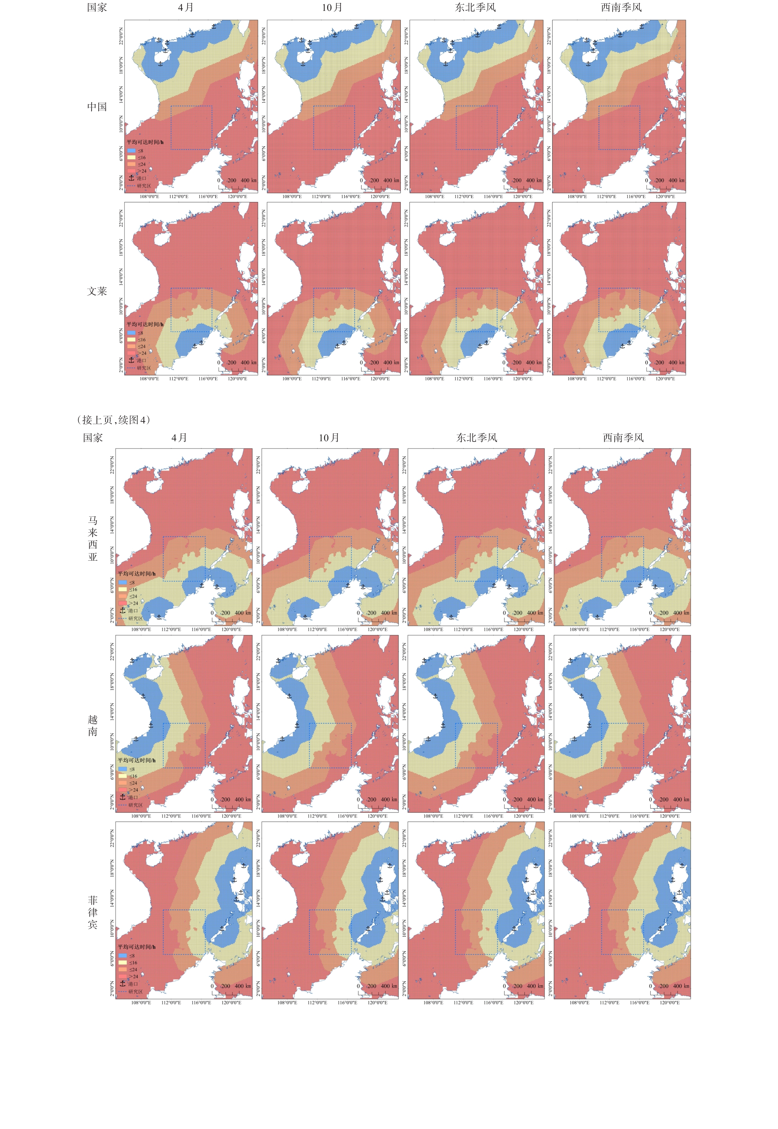
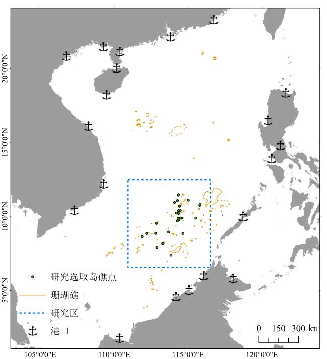
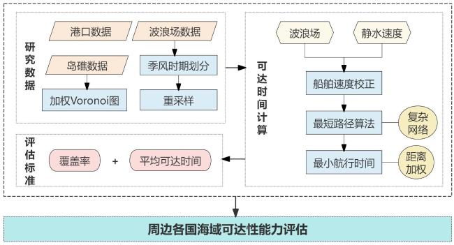
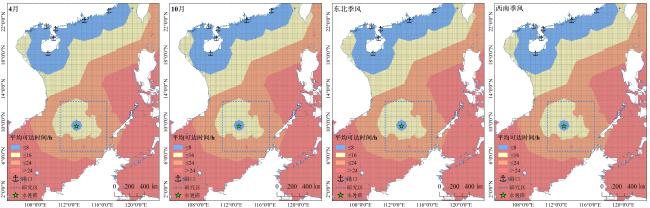
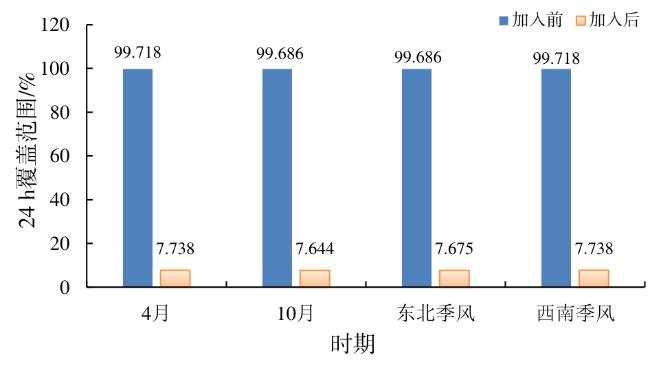
南沙群岛周边海域作为世界上最繁忙的海域之一,是海难事故的频发区,快速的海上搜救是保障人民生命财产安全的重要措施,因此,研究南沙海域的搜救可达性就显得尤为重要。文章基于乘法加权Voronoi图对南沙群岛27个岛礁的影响范围进行了划分,利用船速校正模型得到波浪场影响下船舶航行的实际速度,然后通过最短路径算法计算得到南沙海域周边5国共20个港口至该区域的加权平均可达时间,并使用多种评价指标对各国的可达性能力进行评估分析。结果显示:1)马来西亚至南沙海域的综合可达性最优,平均可达时间最短,其次是文莱、菲律宾和越南,平均可达时间均在20 h以内。而中国至该海域的可达性较差,排名最后。2)新增永暑礁港口后,中国的可达性得到显著提高,平均可达时间缩短至15.54 h,24 h覆盖范围增加了约92.0%。3)鉴于距离南沙海域较远,中国应该加强在远海岛礁建设中转基地及配套搜救设施的能力,这一举措将显著提高中国至中、远海区域的可达性。
关键词: 海上搜救; 可达性; 加权Voronoi图; 最小航行时间; 南沙群岛
石绍宸 , 吴文周 , 张鹏 , 苏奋振 . 南沙海域搜救可达性评估[J]. 热带地理, 2024 , 44(11) : 2015 -2024 . DOI: 10.13284/j.cnki.rddl.20230953
The sea surrounding the Nansha Islands is one of the busiest in the world, where maritime accidents occur frequently. During such events, rapid maritime search and rescue (SAR) operations are important for protecting lives and property of the people; therefore, it is particularly important to study SAR accessibility in the Nansha Sea. In this study, we established the influence range of 27 islands and reefs within the Nansha Islands based on a multiplicative weighted Voronoi diagram. The actual ship navigation speed under the influence of the wave field was obtained using the ship speed correction model. The shortest path algorithm was used to calculate the weighted minimum average reachable time from the study area to 20 ports across five countries surrounding the Nansha Sea. The accessibility of each country was evaluated and analyzed using various evaluation indices. Of the neighboring ports, Kota Kinabalu in Malaysia demonstrated the best accessibility to the Spratly Islands, with an average accessibility time of 18.23 h. This was followed by the ports of Mora and Belawi in Brunei, Palawan in the Philippines, Nha Trang in Vietnam, and Sandakan in Malaysia. In contrast, Chinese ports, except for Sanya, exhibited poor accessibility, with all having an average accessibility time exceeding 40 h. Among neighboring countries, Malaysia had the shortest average accessibility time of 16.26 h, followed by Brunei, the Philippines, and Vietnam, with average accessibility time of less than 19 h. China, being farther away from the study area, had an average accessibility time of over 33 h to the Nansha Sea. Based on this, we added the port of Yongshu Reef to those examined in our previous analysis and conducted scenario simulation, the average access time for China improved significantly, decreasing to15.54 h. This study aimed to provide a reference for the future dynamic deployment of maritime SAR resources in China.
表1 南沙主要岛礁基本信息Table 1 Basic information of main islands and reefs in Nansha |
| 名称 | 面积/m2 | 等面积圆半径/m |
|---|---|---|
| 美济礁 | 5 660 000 | 1 342.25 |
| 渚碧礁 | 4 300 000 | 1 169.93 |
| 永暑礁 | 2 800 000 | 944.07 |
| 太平岛 | 510 000 | 402.91 |
| 南威岛 | 480 000 | 390.88 |
| 毕生礁 | 476 000 | 389.25 |
| 鸿庥岛 | 468 000 | 385.96 |
| 中业岛 | 410 000 | 361.26 |
| 弹丸礁 | 350 000 | 333.78 |
| 华阳礁 | 280 000 | 298.54 |
| 南子岛 | 260 000 | 287.68 |
| 无乜礁 | 256 000 | 285.46 |
| 南薰礁 | 180 000 | 239.36 |
| 西月岛 | 180 000 | 239.36 |
| 北子岛 | 160 000 | 225.67 |
| 景宏岛 | 160 000 | 225.67 |
| 柏礁 | 150 000 | 218.51 |
| 西礁 | 130 000 | 203.42 |
| 染青沙洲 | 120 000 | 195.44 |
| 琼礁 | 120 000 | 195.44 |
| 赤瓜礁 | 102 000 | 180.19 |
| 马欢岛 | 90 000 | 169.26 |
| 安波沙洲 | 90 000 | 169.26 |
| 东门礁 | 80 000 | 159.58 |
| 南钥岛 | 80 000 | 159.58 |
| 敦谦沙洲 | 60 000 | 138.20 |
| 费信岛 | 40 000 | 112.84 |
表2 船舶速度校正系数Table 2 Ship Speed Correction Factors |
| 夹角 | 航行状态 | 校正系数ƒ[kn/ƒt2] |
|---|---|---|
| 0°≤Θ<45° | 顺流Following seas | 0.008 3 |
| 45°≤Θ<135° | 竞流Beam seas | 0.016 5 |
| 135°≤Θ≤180° | 逆流Head seas | 0.024 8 |
表3 南海周边国家20个港口至南沙海域的可达性 (h)Table 3 Accessibility from 20 ports in surrounding countries to the Nansha Sea Area |
| 排序 | 国家 | 港口 | 4月 | 10月 | 东北 季风 | 西南 季风 | 平均 时间 |
|---|---|---|---|---|---|---|---|
| 1 | 马来西亚 | 哥打基纳 巴卢港 | 18.23 | 18.24 | 18.24 | 18.23 | 18.23 |
| 2 | 文莱 | 摩拉港 | 19.13 | 19.14 | 19.14 | 19.13 | 19.13 |
| 3 | 菲律宾 | 巴拉望港 | 20.50 | 20.51 | 20.51 | 20.50 | 20.51 |
| 4 | 文莱 | 白拉奕港 | 20.52 | 20.53 | 20.54 | 20.52 | 20.53 |
| 5 | 越南 | 芽庄港 | 20.67 | 20.69 | 20.68 | 20.66 | 20.67 |
| 6 | 马来西亚 | 山打根港 | 22.60 | 22.61 | 22.61 | 22.60 | 22.60 |
| 7 | 越南 | 头顿港 | 24.17 | 24.19 | 24.19 | 24.16 | 24.18 |
| 8 | 菲律宾 | 八打雁港 | 29.23 | 29.26 | 29.24 | 29.24 | 29.24 |
| 9 | 马来西亚 | 古晋港 | 29.84 | 29.84 | 29.86 | 29.83 | 29.85 |
| 10 | 越南 | 岘港 | 30.04 | 30.07 | 30.07 | 30.04 | 30.06 |
| 11 | 菲律宾 | 拉乌尼翁港 | 33.65 | 33.68 | 33.66 | 33.65 | 33.66 |
| 12 | 中国 | 三亚港 | 34.01 | 34.05 | 34.03 | 34.01 | 34.02 |
| 13 | 菲律宾 | 马尼拉港 | 36.43 | 36.46 | 36.44 | 36.43 | 36.44 |
| 14 | 中国 | 海口港 | 41.32 | 41.37 | 41.34 | 41.32 | 41.34 |
| 15 | 中国 | 湛江港 | 42.10 | 42.15 | 42.13 | 42.10 | 42.12 |
| 16 | 菲律宾 | 阿帕里港 | 42.31 | 42.35 | 42.33 | 42.32 | 42.33 |
| 17 | 中国 | 珠海港 | 43.34 | 43.40 | 43.37 | 43.34 | 43.36 |
| 18 | 越南 | 海防港 | 45.58 | 45.62 | 45.60 | 45.57 | 45.59 |
| 19 | 中国 | 北海港 | 45.91 | 45.95 | 45.93 | 45.90 | 45.92 |
| 20 | 中国 | 汕头港 | 48.58 | 48.65 | 48.61 | 48.58 | 48.60 |
表4 南海周边5国不同季风时期的平均可达时间 (h)Table 4 Average reachable time for different monsoon periods in five countries |
| 国家 | 4月 | 10月 | 东北季风 | 西南季风 | 平均时间 | |
|---|---|---|---|---|---|---|
| 马来西亚 | 16.26 | 16.26 | 16.27 | 16.26 | 16.26 | |
| 文莱 | 17.22 | 17.23 | 17.23 | 17.22 | 17.23 | |
| 菲律宾 | 18.73 | 18.75 | 18.74 | 18.73 | 18.74 | |
| 越南 | 18.88 | 18.90 | 18.89 | 18.87 | 18.89 | |
| 中国 | 未加入 | 33.04 | 33.08 | 33.06 | 33.04 | 33.05 |
| 加入 | 15.54 | 15.55 | 15.55 | 15.53 | 15.54 | |
|

1 https://cds.climate.copernicus.eu/
2 https://amti.csis.org/
3 http://nh-rescue.cn/
4 https://asean.org/
石绍宸:提出研究设想,数据处理与分析,成图制作,论文撰写与修改;
吴文周:论文修改指导;
张 鹏:研究数据支持;
苏奋振:研究框架修改,论文提升修改。
|
陈艳艳,魏攀一,赖见辉,张伟伟,冯国臣. 2015. 基于GIS的区域公交可达性计算方法. 交通运输系统工程与信息,15(2):61-67.
Chen Yanyan, Wei Panyi, Lai Jianhui, Zhang Weiwei, and Feng Guochen. 2015. A Calculation Method of Area Public Transit Accessibility Based on GIS. Transportation System Engineering and Information, 15(2): 61-67.
|
|
陈韶阳,肖利,刘娜,龚彦维,肖云. 2022. 可持续发展视角下的南海岛礁评估分类. 热带地理,42(7):1039-1049.
Chen Shaoyang, Xiao Li, Liu Na, Gong Yanwei, and Xiao Yun. 2022. Classificatory Assessment of Islands and Reefs in the South China Sea from the Perspective of Sustainable Development. Tropical Geography, 42(7): 1039-1049.
|
|
Doshi D, Malhotra B, Bressan S, and Lam J. 2012. Mining Maritime Schedules for Analysing Global Shipping Networks. International Journal of Business Intelligence and Data Mining, 7(3): 186-202.
|
|
Guo L and Yang Z. 2019. Relationship between Shipping Accessibility and Maritime Transport Demand: The Case of Mainland China. Networks and Spatial Economics, 19: 149-175.
|
|
郭丽敏,周廷刚,苏迎春. 2014. 基于加权Voronoi图的城市腹地界定方法研究——以成渝经济圈为例. 地球信息科学学报,16(3):411-417.
Guo Limin, Zhou Tinggang, and Su Yingchun. 2014. Definition of Urban Hinterlands of Chengdu-Chongqing Economic Circle Based on Weighted Voronoi Diagram. Journal of Geoinformation Science, 16(3): 411-417.
|
|
黄企洲,方文东,陈荣裕. 2001. 南沙群岛海区西南季风变化与表层流结构和演变关系的探讨. 热带海洋学报,(1):18-26.
Huang Qizhou, Fang Wendong, and Chen Rongyu. 2001. A Discussion on Relations between Southwest Monsoon Variation and Sea Surface Circulation Structure and Evolution in Nansha Islands Sea Area. Journal of Tropical Oceanography, (1): 18-26.
|
|
黄忠刚,张哲,罗容,刘报春. 2011. 海洋划界法理与领海基点信息系统建立. 海洋测绘,31(5):79-81.
Huang Zhonggang, Zhang Zhe, Luo Rong, and Liu Baochun. 2011. Research on Law and Rule of Ocean Delimitation and Management on Information of Terrain Base Point. Ocean Surveying and Mapping, 31(5): 79-81.
|
|
黄季夏,张天媛,王利,杨林生,葛全胜. 2020. 俄罗斯油气资源空间分布格局及可达性评估. 地理学报,75(9):2009-2024.
Huang Jixia, Zhang Tianyuan, Wang Li, Yang Linsheng, and Ge Quansheng. 2020. Spatial Distribution Patterns and the Accessibility Evaluation of Oil and Gas Resources in Russia. Journal of Geography, 75 (9): 2009-2024.
|
|
柯东胜,许时耕. 1997. ENSO对南沙海域气候状况的影响. 气象学报,(4):123-128.
Ke Dongsheng and Xu Shigeng. 1997. The Effect of ENSO on the Climatic State in Nansha. Journal of Meteorology, (4): 123-128.
|
|
刘雅奇,史誉洲,曹石勇. 2023. 船舶航迹数据采集与可视化在海上搜救中的应用. 舰船科学技术,45(18):166-169.
Liu Yaqi, Shi Yuzhou, and Cao Shiyong. 2023. Application of Ship Track Data Collection and Visualization in Maritime Search and Rescue. Ship Science and Technology, 45(18): 166-169.
|
|
林婉妮,王诺,高忠印,吴迪. 2021. 边远海域救援船舶与直升机联合搜救优化. 交通运输工程学报,21(2):187-199.
Lin Wanni, Wang Nuo, Gao Zhongyin, and Wu Di. 2021. Associated Searching and Rescuing Optimization of Salvage Vessels and Helicopters in Remote Sea Area. Journal of Transportation Engineering, 21(2): 187-199.
|
|
李金明. 2002. 南沙海域的石油开发及争端的处理前景. 厦门大学学报(哲学社会科学版),(4):52-59.
Li Jinming. 2002. Oil Resource around the Nansha Islands: Its Development and Prospects in Handling the Disputes. Journal of Xiamen University (Philosophy and Social Sciences Edition), (4): 52-59.
|
|
李妍妍. 2014. Dijkstra最短路径分析算法的优化实现. 测绘与空间地理信息,37(5):172-173,190.
Li Yanyan. 2014. The Optimization Algorithm Dijkstra Implementation of Shortestpath Analysis. Surveying and Spatial Geographic Information, 37(5): 172-173, 190.
|
|
李煜,张亦汉,李建程. 2015. 广州市不同交通网的可达性差异分析. 中山大学学报(自然科学版),54(2):133-140.
Li Yu, Zhang Yihan, and Li Jiancheng. 2015. Differential Analysis of Accessibility for Different Transportation Network in Guangzhou. Journal of Sun Yat-sen University (Natural Science Edition), 54(2): 133-140.
|
|
刘烨. 2015. 南海周边国家海军基地与港口概要. 现代军事,(2):62-64.
Liu Ye. 2015. Overview of Naval Bases and Ports of Countries Surrounding the South China Sea. Modern Military, (2): 62-64.
|
|
梅志雄,徐颂军,欧阳军. 2012. 珠三角城市群空间吸引力范围界定及其变化. 经济地理,32(12):47-60.
Mei Zhixiong, Xu Songjun, and Ouyang Jun. 2012. The Delimitation and Change of Cities Space Attractive Scopes in the Pearl River Delta. Economic Geography, 32(12): 47-60.
|
|
苗李莉,蒋卫国,万圆,何湜,陈云浩. 2013. 基于加权Voronoi图的北京市湿地功能分区研究. 地球信息科学学报,15(4):554-559.
Miao Lili, Jiang Weiguo, Wan Yuan, He Shi, and Chen Yunhao. 2013. Beijing Urban Wetland Function Zoning Based on the Weighted Voronoi Diagram. Journal of Geoinformation Science, 15(4): 554-559.
|
|
Mannarini G, Coppini G, Oddo P, and Pinardi N. 2013. A Prototype of Ship Routing Decision Support System for an Operational Oceanographic Service. The International Journal on Marine Navigation and Safety of Sea Transportation, 7(1): 53-59.
|
|
Siljander M, Venäläinen E, Goerlandt F, and Pellikka P. 2015. GIS-Based Cost Distance Modelling to Support Strategic Maritime Search and Rescue Planning: A Feasibility Study. Applied Geography, 57: 54-70.
|
|
石伟,苏奋振,周成虎,吴文周. 2014. 南沙岛礁及周边港口可达性评价模型研究. 地理学报,69(10):1510-1520.
Shi Wei, Su Fenzhen, Zhou Chenghu, and Wu Wenzhou. 2014. Research on Accessibility Model of Nansha Islands and Surrounding Seaports. Journal of Geography, 69(10): 1510-1520.
|
|
宋博,王辉赞,张韧,刘科峰,黎鑫. 2018. 基于领海基线外推领海、毗连区和专属经济区的2种算法及其比较. 海洋开发与管理,35(2):63-66.
Song Bo, Wang Huizan, Zhang Ren, Liu Kefeng, and Li Xin. 2018. Two Algorithms and the Comparison for Extrapolating Territorial Sea, Contiguous Zone and Exclusive Economic Zone Based on Baselines of Territorial Waters. Ocean Development and Management, 35(2): 63-66.
|
|
史春林. 2017. 中国在南海岛礁建设搜救基地问题研究. 太平洋学报,25(6):78-87.
Shi Chunlin. 2017. Challenges Facing China in Building Search and Rescue Bases on Islands and Reefs in the South China Sea. Pacific Journal, 25(6): 78-87.
|
|
王军敏. 2016. 论南沙群岛的群岛地位. 法治研究,(4):11-30.
Wang Junmin. 2016. On the Archipelagic Status of the the Nansha Islands. Research on the Rule of Law, (4): 11-30.
|
|
王超,廖倩如. 2020. 马来西亚港口发展分析. 交通企业管理,35(3):12-14.
Wang Chao and Liao Qianru. 2020. Analysis of the Development of Malaysia Ports. Transportation Enterprise Management, 35(3): 12-14.
|
|
闫俊涛. 2015. 基于GPS的自定位海上搜救报警系统. 北京:北京邮电大学.
Yan Juntao. 2015. Maritime Search and Rescue Alarm System Based on GPS Positioning Technology. Beijing: Beijing University of Posts and Telecommunications.
|
|
越南海军基地和军港. 2003. 当代海军,(7):22.
Vietnamese Naval Bases and MilitaryPorts. 2003. Contemporary Navy, (7): 22.
|
|
朱岿. 2022. 海上搜救目标漂移预测模型研究及应用. 武汉:中国地质大学.
Zhu Kui. 2022. Research and Application of Target Drift Prediction Model for Maritime Search and Rescue. Wuhan: China University of Geosciences.
|
|
张清臣,李云斌,孙玉涛. 2014. 基于北斗系统的海上搜救体系研究. 天津航海,(3):64-65,70.
Zhang Qingchen, Li Yunbin, and Sun Yutao. 2014. Research on Maritime Search and Rescue System Based on Beidou System. Tianjin Navigation, (3): 64-65, 70.
|
|
Zhou Xiao, Cheng Liang, Min Kaifu, Zuo Xiaoyi, Yan Zhaojin, Ruan Xiaoguang, Chu Sensen, and Li Manchun. 2020. A Framework for Assessing the Capability of Maritime Search and Rescue in the South China Sea. International Journal of Disaster Risk Reduction, 47: 101568.
|
|
邹伟,刘永学,李满春,张荷霞,陈映雪. 2014. 南海历史地理争端空间分布与关联性研究. 地球信息科学学报,16(2):249-256.
Zou Wei, Liu Yongxue, Li Manchun, Zhang Hexia, and Chen Yingxue. 2014. Study on Spatial Distribution and Correlation of Historical Disputes in the South China Sea with GIS. Journal of Geoinformation Science, 16(2): 249-256.
|
|
张厚和,刘鹏,廖宗宝,赫栓柱,徐庆梅. 2018. 南沙海域主要盆地地质特征与油气分布. 中国石油勘探,23(1):62-70.
Zhang Houhe, Liu Peng, Liao Zongbao, He Shuanzhu, and Xu Qingmei. 2018. Geological Characteristics and Hydrocarbon Distribution in Major Sedimentary Basins in Nansha Sea Areas. China Petroleum Exploration, 23(1): 62-70.
|
|
赵焕庭,王丽荣,袁家义. 2017. 南海诸岛的自然环境、资源与开发——纪念中国政府收复南海诸岛70周年(3). 热带地理,37(5):659-680,693.
Zhao Huanting, Wang Lirong, and Yuan Jiayi. 2017. Natural Environment, Resources and Development of the South China Sea Islands:The 70th Anniversary of Recovery of the South China Sea Islands (3). Tropical Geography, 37(5): 659-680, 693.
|
|
张晓贺,桑会勇,翟亮,卫东. 2023. 一种异质空间下加权Voronoi图的栅格生成算法. 测绘科学,48(5):231-238.
Zhang Xiaohe, Sang Huiyong, Zhai Liang, and Wei Dong. 2023. A raster-based algorithm of weighted Voronoi diagram in heterogeneous space. Surveying and Mapping Science, 48(5): 231-238.
|
|
张协奎,张亚芬. 2018. 南部沿海主要港口空间结构分析及互联互通定位. 广西民族大学学报(哲学社会科学版),40(2):160-168.
Zhang Xiekui and Zhang Yafen. 2018. Space Structure Analysis of the Key Ports on the Southern Coast of China and Their Strategic Position of Interconnection. Journal of Guangxi University for Nationalities (Philosophy and Social Sciences Edition), 40(2): 160-168.
|
|
钟浩. 2021. 21世纪海上丝绸之路沿线主要国家港口综合竞争力及效应研究. 湛江:广东海洋大学.
Zhong Hao. 2021. A Study on the Comprehensive Competitiveness and Effect of Ports in Major Countries along the 21st Century Maritime Silk Road. Zhanjiang: Guangdong Ocean University.
|
/
| 〈 |
|
〉 |

