
粤港澳大湾区城市群自然灾害危险性区划与对策
|
王钧(1988―),男,甘肃人,博士,副研究员,主要从事地质灾害形成机理与风险评估研究工作,(E-mail)wangjun210@ mails.ucas.ac.cn; |
收稿日期: 2024-11-30
修回日期: 2025-01-16
网络出版日期: 2025-04-15
基金资助
广东省自然科学基金-青年提升项目(2024A1515030114)
国家自然科学基金项目(42271091)
Natural Disaster Regionalization and Countermeasures in the Guangdong-Hong Kong-Macao Greater Bay Area Urban Agglomeration
Received date: 2024-11-30
Revised date: 2025-01-16
Online published: 2025-04-15
围绕粤港澳大湾区防灾减灾的重大需求,开展大湾区自然灾害危险性区划与对策研究。首先,基于陆地地貌分类体系,进行大湾区地貌一级和二级区划;其次,根据各地貌单元内主导自然灾害的强度,进行自然灾害的一级和二级区划;最后,根据区划单元内自然灾害的主控因素进行灾害危险性评估与区划,并针对性提出大湾区自然灾害防灾减灾对策建议。结果表明:1)大湾区地貌可划分山地、丘陵、台地、平原4大一级分区和中海拔小起伏山地、低海拔侵蚀剥蚀丘陵、低海拔冲积台地、低海拔海积冲积平原等10个二级分区;2)大湾区可划分为山地丘陵灾害区、平原台地灾害区和河口海岸灾害区3个灾害一级分区,面积占比分别为52.77%、40.43%和6.80%;3)大湾区可划分为低海拔小起伏山地灾害区、低海拔海积冲积平原地面沉降区、低海拔平原台地洪涝区等14个灾害二级分区,其中,面积最大的为低海拔小起伏山地灾害区,面积占比为36.67%;4)大湾区山地丘陵灾害高危险区主要在肇庆市的德庆、怀集、广宁等县区、广州市北部的从化区、惠州市的龙门、博罗等区域,平原台地灾害高危险区主要在珠海市斗门区、广州市花都区的广花盆地、南沙区、佛山市高明区等区域,河口海岸灾害高危险区主要在珠海市斗门区、珠三角出海口附近;并从4方面针对性地提出大湾区自然灾害的防灾减灾对策。
王钧 , 王祥林 , 宫清华 , 袁少雄 , 刘博文 . 粤港澳大湾区城市群自然灾害危险性区划与对策[J]. 热带地理, 2025 , 45(4) : 660 -672 . DOI: 10.13284/j.cnki.rddl.20240779
In the context of global climate change, natural disasters pose increasingly serious threats to the Guangdong-Hong Kong-Macao Greater Bay Area. Therefore, in this study, we aimed to conduct integrated comprehensive zoning of natural disasters and to develop disaster prevention and mitigation countermeasures for the Greater Bay Area. To achieve this objective, we first carried out geomorphological division of the Greater Bay Area based on the land geomorphological classification system. Second, we performed comprehensive zoning of natural disasters according to the intensity of dominant natural disasters in various geomorphological units. Finally, we conducted risk zoning of natural disasters according to the main controlling factors of natural disasters in each zoning units. Based on the geomorphology of the Greater Bay Area and the risk of natural disasters, we proposed natural disaster prevention and mitigation countermeasures. The results show that: (1) The landform of the Greater Bay Area can be divided into four major first-class divisions: mountains, hills, platforms and plains. The landforms of the Greater Bay Area can be divided into 10 secondary subdivisions, including medium-altitude small undulating mountains, low-altitude small undulating mountains, low-altitude erosion and denudation hills, low-altitude erosion and denudation platforms, low-altitude alluvial platforms, low-altitude alluvial flood platforms, low-altitude alluvial plains, low-altitude marine plains, low-altitude marine alluvial plains, and low-altitude estuarine coasts. Among these subdivisions, low-altitude small undulating mountains represent the largest area (21,618.28 km2), while low-altitude erosion and denudation platforms represent the smallest area (849.77 km2). (2) The Greater Bay Area can be divided into three first-level major disaster subdivisions: mountain and hill disaster areas (52.77%), plain and platform disaster areas (40.43%), and estuary and coast disaster areas (6.80%). (3) The Greater Bay Area can be further divided into second-level disaster subdivisions, including the small undulating and low-altitude mountain disaster area, low-altitude alluvial plain land subsidence area, low-altitude plain and platform flood area, and 14 others. The largest second-level disaster subdivision area is the small undulating low-altitude mountain disaster area (20,892.18 km2), which is distributed in the east, north, and west of the Greater Bay Area, followed by the low-altitude plain and platform flood disaster area (13,320.98 km2), which is mainly distributed in Guangzhou, Jiangmen, Shenzhen, Huizhou, and Zhaoqing cities, among other areas. The karst collapse area of the low-altitude platform represents the smallest second-level disaster subdivision (163.62 km2) and is mainly distributed in some areas of Enping and Jiangmen cities. (4) The natural disaster risk in the Greater Bay Area can be divided into high-risk, medium-risk, and low-risk areas. The high-risk areas for mountain disasters are mainly in Deqing, Huaiji, and Guangning of Zhaoqing City; and Conghua District in the north of Guangzhou City, Longmen, Boluo, and other regions in Huizhou City. The high-risk areas for plain and platform disasters are mainly in Doumen District, Zhuhai City, Guanghua Basin, Huadu District, Nansha District, Guangzhou City, Foshan City, and other regions. The high-risk areas for estuary and coast disasters are mainly in Doumen District, Zhuhai City, and near the mouth of the Pearl River Delta. In this study, we proposed disaster prevention and mitigation countermeasures for natural disasters in the Greater Bay Area from four perspectives. Our results serve as a valuable reference for the Greater Bay Area urban agglomeration in regional development planning, comprehensive disaster reduction planning, and the improvement of disaster prevention and mitigation capabilities.
表1 粤港澳大湾区不同单元的邻域面积、平均地势起伏度和 的计算Table 1 Caculation of neighbourhood area, mean terrain relief and of different units in Guangdong-Hong Kong-Macao Greater Bay Area |
| 单元大小 | 邻域面积/ 104 m2 | 平均起伏度/m | 单位面积 起伏度/m | 单元大小 | 邻域面积 /104 m2 | 平均起伏度/m | 单位面积 起伏度/m | ||
|---|---|---|---|---|---|---|---|---|---|
| 3×3 | 0.141 | 7.459 | 53.045 | ― | 19×19 | 5.641 | 51.428 | 9.118 | 10.149 |
| 4×4 | 0.250 | 11.052 | 44.208 | 2.463 | 20×20 | 6.250 | 53.516 | 8.563 | 9.739 |
| 5×5 | 0.391 | 14.518 | 37.166 | 4.513 | 21×21 | 6.891 | 55.557 | 8.063 | 9.275 |
| 6×6 | 0.563 | 17.846 | 31.727 | 6.185 | 22×22 | 7.563 | 57.556 | 7.611 | 8.762 |
| 7×7 | 0.766 | 21.036 | 27.476 | 7.536 | 23×23 | 8.266 | 59.514 | 7.200 | 8.203 |
| 8×8 | 1.000 | 24.094 | 24.094 | 8.614 | 24×24 | 9.000 | 61.434 | 6.826 | 7.603 |
| 9×9 | 1.266 | 27.028 | 21.355 | 9.458 | 25×25 | 9.766 | 63.318 | 6.484 | 6.966 |
| 10×10 | 1.563 | 29.848 | 19.103 | 10.102 | 26×26 | 10.563 | 65.168 | 6.170 | 6.295 |
| 11×11 | 1.891 | 32.563 | 17.223 | 10.573 | 27×27 | 11.391 | 66.986 | 5.881 | 5.592 |
| 12×12 | 2.250 | 35.182 | 15.636 | 10.892 | 28×28 | 12.250 | 68.773 | 5.614 | 4.860 |
| 13×13 | 2.641 | 37.714 | 14.282 | 11.079 | 29×29 | 13.141 | 70.531 | 5.367 | 4.102 |
| 14×14 | 3.063 | 40.165 | 13.115 | 11.149 | 30×30 | 14.063 | 72.957 | 5.188 | 3.320 |
| 15×15 | 3.516 | 42.543 | 12.101 | 11.115 | 31×31 | 15.016 | 73.964 | 4.926 | 2.533 |
| 16×16 | 4.000 | 44.853 | 11.213 | 10.989 | 32×32 | 16.000 | 75.642 | 4.728 | 1.708 |
| 17×17 | 4.516 | 47.101 | 10.431 | 10.781 | 33×33 | 17.016 | 77.295 | 4.543 | 0.863 |
| 18×18 | 5.063 | 49.291 | 9.737 | 10.498 |
表2 粤港澳大湾区地貌分区统计Table 2 Statistic of geomorphological zoning of the Guangdong-Hong Kong-Macao Greater Bay Area |
| 基本地貌类型 | 成因类型 | 地貌分区 名称 | 面积/ km2 | 主要分布区域 | ||
|---|---|---|---|---|---|---|
| 起伏度 | 海拔 | 成因 | 次级成因 | |||
| 山地 | 中海拔 | — | — | 中海拔小起伏 山地 | 1 648.89 | 主要分布在肇庆市和清远市交界的罗壳山,以及广州从化与惠州博罗县交界的罗浮山等部分区域。 |
| 低海拔 | — | — | 低海拔小起伏 山地 | 21 618.28 | 大湾区东、北、西部区域分布广泛,东部主要有沿惠州惠东县南侧分布的莲花山脉等,西部主要为江门开平市西侧的天露山、肇庆市鼎湖山等,北部有沿广州从化区东北分布的天堂顶~三角顶~桂峰山,香港部分地区等。 | |
| 丘陵 | 低海拔 | 流水 | 侵蚀剥蚀 | 低海拔侵蚀 剥蚀丘陵 | 6 793.77 | 广泛分布于大湾区陆地和部分岛屿,多环绕和毗邻低山、台地、平原的边缘,主要分布于肇庆市、广州市、惠州市、深圳市、佛山市等地。 |
| 台地 | 低海拔 | 流水 | 冲积 | 低海拔冲积 台地 | 2 413.04 | 主要分布在大湾区中部、西部和东部地区,零星分布,主要分布在江门市、广州市、东莞市和深圳市等地。 |
| 冲积洪积 | 低海拔冲积 洪积台地 | 1 091.67 | 主要分布在大湾区的西部地区,零星分布,主要分布在江门市、佛山市部分地区。 | |||
| 侵蚀剥蚀 | 低海拔侵蚀 剥蚀台地 | 849.77 | 主要分布在大湾区的中部和西部,零星分布,主要分布在佛山市、深圳市、东莞市等地区。 | |||
| 平原 | 低海拔 | 流水 | 冲积 | 低海拔冲积平原 | 8 380.02 | 广泛分布在大湾区的东部、西部和北部地区,主要分布在山地、丘陵和台地的边缘地区,在肇庆市、广州市、江门市、惠州市等地区分布。 |
| 海成 | 海积 | 低海拔海积平原 | 1 165.42 | 主要分布在大湾区的西部,在珠海市、江门市、惠州市均有分布。 | ||
| 海积冲积 | 低海拔海积 冲积平原 | 9 134.15 | 主要分布在大湾区的中部和东部,其中珠江三角洲为该区平原的主体,是最大的堆积形态。 | |||
| 流水+ 海成 | 河流与海洋动力相互作用 | 低海拔河口 海岸 | 3 872.67 | 主要为陆地到海的区域,是河流与海洋动力相互作用的地区,地貌上主要有水下台地、水下三角洲、水下岸坡等类型,主要分布在大湾区陆地和海交界地区,如广州市、中山市、江门市、珠海市、香港、深圳市、惠州市。 | ||
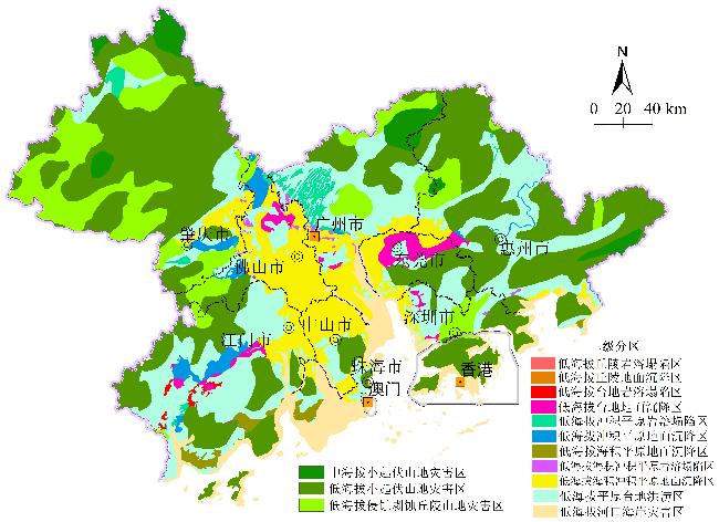
图5 粤港澳大湾区自然灾害二级分区Fig.5 The secondary zoning of natural disasters of the Guangdong-Hong Kong-Macao Greater Bay Area |
表3 粤港澳大湾区自然灾害二级区划结果Table 3 Results of secondary zoning of natural disasters of the Guangdong-Hong Kong-Macao Greater Bay Area |
| 一级分区 | 一级分区 | 二级分区 | 二级分区 | 主要分布区域 | ||
|---|---|---|---|---|---|---|
| 面积/km2 | 占比/% | 面积/km2 | 占比/% | |||
| 山地丘陵 灾害区 (U1) | 30 060.94 | 52.77 | 中海拔小起伏 山地灾害区(U1-1) | 1 648.89 | 2.89 | 以崩滑流山地灾害为主,主要分布在肇庆市罗壳山、惠州罗浮山等少部分区域,主要面临崩滑流山洪等山地灾害的威胁 |
| 低海拔小起伏 山地灾害区(U1-2) | 20 892.18 | 36.67 | 广泛分布于大湾区东、北、西部地区,主要面临崩滑流山洪等山地灾害的威胁 | |||
| 低海拔侵蚀剥蚀 丘陵山地灾害区(U1-3) | 6 543.26 | 11.49 | 大多环绕和毗邻低山、台地、平原的边缘分布,主要分布于肇庆市、广州市、惠州市、深圳市、佛山市等地,主要面临崩滑流等山地灾害的威胁 | |||
| 低海拔丘陵岩溶 塌陷区(U1-4) | 233.91 | 0.41 | 零星分布在广州市、惠州市北部、肇庆市、江门市部分地区,主要面临地面塌陷灾害威胁 | |||
| 低海拔丘陵地面 沉降区(U1-5) | 742.7 | 1.30 | 零星分布在东莞市、肇庆市、江门市、中山市、深圳市、惠州市的部分地区,主要面临地面沉降威胁 | |||
| 平原台地 灾害区 (U2) | 23 034.07 | 40.43 | 低海拔台地岩溶 塌陷区(U2-1) | 163.62 | 0.29 | 主要分布在江门市恩平市的部分地区,主要面临岩溶地面塌陷灾害威胁 |
| 低海拔台地地面 沉降区(U2-2) | 908.14 | 1.59 | 主要分布在东莞市、佛山市、江门市、深圳市和广州市的部分地区,主要面临地面沉降灾害威胁 | |||
| 低海拔冲积平原岩 溶塌陷区(U2-3) | 1 109.29 | 1.94 | 主要分布在佛山市、肇庆市、江门市和广州市的小部分地区,主要面临岩溶地面塌陷威胁 | |||
| 低海拔冲积平原 地面沉降区(U2-4) | 693.49 | 1.22 | 主要分布在佛山市、肇庆市、江门市的小部分地区,主要面临地面沉降灾害威胁 | |||
| 低海拔海积平原 地面沉降区(U2-5) | 481.66 | 0.85 | 主要分布在江门市南部区域,面临地面沉降灾害的威胁 | |||
| 低海拔海积冲积平原岩溶塌陷区(U2-6) | 977.18 | 1.71 | 主要分布于广州市、佛山市和肇庆市等地区,面临岩溶地面塌陷的威胁 | |||
| 低海拔海积冲积平原地面沉降区(U2-7) | 5 379.71 | 9.44 | 广泛分布在广州市、佛山市、江门市、中山市、珠海市、肇庆市和东莞市,面临地面沉降灾害的威胁 | |||
| 低海拔平原台地 洪涝区(U2-8) | 13 320.98 | 23.38 | 广泛分布,广州市、江门市、深圳市、惠州市等地区的分布面积较大,面临珠江流域洪水与城市暴雨洪涝等灾害威胁 | |||
| 河口海岸 灾害区 (U3) | 3 872.75 | 6.80 | 低海拔河口海岸 灾害区(U3-1) | 3 872.75 | 6.80 | 主要分布在大湾区陆地和海交界的地区,如广州市、中山市、江门市、珠海市、香港、深圳市、惠州市等地,主要面临台风暴潮、海平面上升、海水入侵、海岸侵蚀等灾害威胁 |
1 http://nr.gd.gov.cn/
2 https://search.asf.alaska.edu/#/
3 https://www.geodata.cn/data/datadetails.html?dataguid=144362119606119&docId=33185
王 钧:梳理研究内容与论文整体撰写;
王祥林:收集与分析数据;
宫清华:确定论文选题、研究思路和审阅总体论文;
袁少雄:制作图件与论文审稿意见修改;
刘博文:论文数据处理和论文修改。
|
陈学兄,常庆瑞,毕如田,刘正春,张小军.2018. 地形起伏度最佳统计单元算法的比较研究. 水土保持研究,25(1):52-56.
Chen Xuexiong, Chang Qingrui, Bi Rutian, Liu Zhengchun, and Zhang Xiaojun. 2018. Comparative Study on the Best Statistical Unit Algorithm of Relief Amplitude. Research of Soil and Water Conservation, 25(1): 52-56.
|
|
陈跃红,张若婧,张晓祥,任立良. 2023. 中国自然区划研究进展与展望. 地理与地理信息科学,39(1):80-90,119.
Chen Yuehong, Zhang Ruojing, Zhang Xiaoxiang, and Ren Liliang. 2023. Progress and Prospect on Natural Regionalization in China. Geography and Geo-Information Science, 39(1): 80-90, 119.
|
|
程维明,周成虎,柴慧霞,赵尚民,李炳元. 2009. 中国陆地地貌基本形态类型定量提取与分析. 地理信息科学学报,11(6):725-736.
Cheng Weiming, Zhou Chenghu, Chai Huixia, Zhao Shangmin, and Li Bingyuan. 2009. Quantitative Extraction and Analysis of Basic Morphological Types of Land Geomorphology in China. Journal of Geo-Information Science, 11(6): 725-736.
|
|
郭鑫,李宏男,张皓. 2024. 强风和地震联合灾害区划图编制方法. 中国科学:技术科学,54(12):2363-2376.
Guo Xin, Li Hongnan, and Zhang Hao. 2024. Methodology for the Combined Strong Wind and Earthquake Hazard Map. Scientia Sinica Technologica, 54(12): 2363-2376.
|
|
广东省自然资源厅. 2023. 广东省乡镇(街道)地质灾害风险调查评价技术要求(1:10 000). (2024-06-09)[2025-03-20]. https://www.doc88.com/p-21699642553505.html.
Department of Natural Resources of Guangdong Province. 2023. Technical Requirements for Geological Hazard Risk Investigation and Evaluation of Townships (Streets) in Guangdong Province (1:10,000). (2024-06-09) [2025-03-20]. https://www.doc88.com/p-21699642553505.html.
|
|
秦绪文,何俊美. 2019. 粤港澳大湾区自然资源与环境图集. 北京:科学出版社.
Qin Xuwen and He Junmei. 2019. Natural Resources and Environment Atlas of Guangdong-Hong Kong-Macao Greater Bay Area. Beijing: Science Press.
|
|
黄莉,王芸清,王伟,宋月,石雨欣. 2024. 粤港澳大湾区复合灾害系统暴露度评估. 郑州大学学报(工学版),45(4):95-101.
Huang Li, Wang Yunqing, Wang Wei, Song Yue, and Shi Yuxin. 2024. Exposure Assessment of Compound Disaster in Guangdong-Hong Kong-Macao Greater Bay Area. Journal of Zhengzhou University (Engineering Science), 45(4): 95-101.
|
|
黎昊,王钧,黄建国,罗依珍,宫清华. 2022. 粤港澳大湾区开发建设与丘陵浅山区山地灾害相关性. 山地学报,40(3):384-395.
Li Hao, Wang Jun, Huang Jianguo, Luo Yizhen, and Gong Qinghua. 2022. Urban Expansion in Guangdong-Hong Kong-Macao Greater Bay Area, China and Resulting Geo-Disasters in Foothills. Mountain Research, 40(3): 384-395.
|
|
黎昊,宫清华,袁少雄,王钧,黄志豪,程玥淞,陈敬业,黄建国. 2023. 基于景观形态的城镇与山地交互作用及其灾害效应——以粤港澳大湾区为例. 热带地理,43(3):408-416.
Li Hao, Gong Qinghua, Yuan Shaoxiong, Wang Jun, Huang Zhihao, Cheng Yuesong, Chen Jingye, and Huang Jianguo. 2023. Urban-Mountain Coupling Characteristics Based on Landscape Form and Its Disaster Effects: A Case Study of the Guangdong-Hong Kong-Macao Greater Bay Area. Tropical Geography, 43(3): 408-416.
|
|
刘仁志,倪晋仁. 2005. 中国滑坡崩塌危险性区划. 应用基础与工程科学学报,13(1):9-18.
Liu Renzhi and Ni Jinren. 2005. Landslide and Rock Fall Hazard Zonation in China. Journal of Basic Science and Engineering, 13(1): 9-18.
|
|
罗日洪,黄锦林,陈丕翔. 2024. 基于权重博弈的粤港澳大湾区洪水风险区划研究. 水利规划与设计,(12):6-11.
Luo Rihong, Huang Jinlin, and Chen Pixiang. 2024. Study on Flood Risk Regionalization of Guangdong-Hong Kong-Macao Greater Bay Area Based on Weight Game. Water Conservancy Planning and Design, (12): 6-11.
|
|
潘东华,贾慧聪,贺原惠子. 2019.自然灾害风险制图研究进展与展望.地理空间信息,17(7):6-10.
Pan Donghua, Jia Huicong, and Heyuan Huizi. 2019. Research Progress and Prospect of Natural Disaster Risk Mapping. Geospatial Information, 17(7): 6-10.
|
|
任鲁川. 1999. 自然灾害综合区划的基本类别及定量方法. 自然灾害学报,8(4):41-48.
Ren Luchuan. 1999. Comprehensive Regionalization of Natural Disaster: Basic Type and Quantitative Method. Journal of Natural Disasters, 8(4): 41-48.
|
|
Selina B, Marcel J F S, and Jim W H. 2007. Flood Risk Management in Europe: Innovation in Policy and Practice. Advances in Natural and Technological Hazards Research, 25: 21-42.
|
|
史培军,王季薇,张钢锋,孔锋,王静爱. 2017. 透视中国自然灾害区域分异规律与区划研究. 地理研究,36(8):1401-1414.
Shi Peijun, Wang Jiwei, Zhang Gangfeng, Kong Feng, and Wang Jing'ai. 2017. Research Review and Prospects of Natural Disasters Regionalization in China. Geographical Research, 36(8): 1401-1414.
|
|
田国珍,刘新立,王平,赵霞,李向荣. 2006. 中国洪水灾害风险区划及其成因分析. 灾害学,21(2):1-6.
Tian Guozhen, Liu Xinli, Wang Ping, Zhao Xia, and Li Xiangrong. 2006. Flood Risk Zoning and Causal Analysis in China. Journal of Catastrophology, 21(2): 1-6.
|
|
吴绍洪,潘韬,刘燕华,邓浩宇,焦珂伟,陆晴,冯爱青,岳溪柳,尹云鹤,赵东升,高江波. 2017. 中国综合气候变化风险区划. 地理学报,72(1):3-17.
Wu Shaohong, Pan Tao, Liu Yanhua, Deng Haoyu, Jiao Kewei, Lu Qing, Feng Aiqing, Yue Xiliu, Yin Yunhe, Zhao Dongsheng, and Gao Jiangbo. 2017. Comprehensive Climate Change Risk Regionalization of China. Acta Geographica Sinica, 72(1): 3-17.
|
|
王玲,吕新. 2009. 基于DEM的新疆地势起伏度分析. 测绘科学,34(1):113-116.
Wang Ling and Lyu Xin. 2009. Analysis of the Relief Amplitude in Xinjiang Based on Digital Elevation Model. Science of Surveying and Mapping, 34(1): 113-116.
|
|
王平. 2001. 基于GIS的自然灾害区划方法研究. 地学前缘,8(4):321-323.
Wang Ping. 2001. Study on Natural Disaster Zoning Method Based on GIS. Earth Science Frontiers, 8(4): 321-323.
|
|
王钧,宫清华,宇岩,袁少雄,陈军,黄光庆. 2020. 粤港澳大湾区城市群自然灾害综合承灾能力评价. 地理研究,39(9):2189-2199.
Wang Jun, Gong Qinghua, Yu Yan, Yuan Shaoxiong, Chen Jun, and Huang Guangqing. 2020. Evaluation of Comprehensive Disaster-Bearing Capacity of Urban Natural Disasters in the Guangdong-Hong Kong-Macao Greater Bay Area. Geographical Research, 39(9): 2189-2199.
|
|
王钧,陈敬业,宫清华,袁少雄,陈军,刘博文,黎昊. 2023. 韧性视角下城市社会脆弱性评估及优化策略—以珠三角城市群为例. 热带地理,43(3):474-483.
Wang Jun, Chen Jingye, Gong Qinghua, Yuan Shaoxiong, Chen Jun, Liu Bowen, and Li Hao. 2023. Urban Social Vulnerability Assessment and Optimization Strategies from the Perspective of Resilience: A Case Study of the Pearl River Delta Urban Agglomeration. Tropical Geography, 43(3): 474-483.
|
|
王瑛,祁京,王姝苓,李璨,俞海洋. 2023. 基于聚类与统计分级的河北省气象灾害综合区划研究. 灾害学,38(2):85-88.
Wang Ying, Qi Jing, Wang Shuling, Li Can, and Yu Haiyang. 2023. Study on Regionalization of Meteorological Disasters in Hebei Province Based on Cluster and Statistics Classification. Journal of Catastrophology, 38(2): 85-88.
|
|
王伟,石雨欣,宋月,王芸清,黄莉,杨天军. 2024 暴雨-滑坡灾害链应急能力评估——以粤港澳大湾区为例. 自然灾害学报,33(4):95-105.
Wang Wei, Shi Yuxin, Song Yue, Wang Yunqing, Huang Li, and Yang Tianjun. 2024. Emergency Capability Assessment of the Rainstorm-Landslide Disaster Chain: Taking the Guangdong-Hong Kong-Macao Greater Bay Area as an Example. Journal of Natural Disaster, 33(4): 95-105.
|
|
汪明,李志雄,史培军. 2021. 全面推进第一次全国自然灾害综合风险普查着力提升防范化解重大灾害风险能力. 中国减灾,(9):18-21.
Wang Ming, Li Zhixiong, and Shi Peijun. 2021. Comprehensively Promote the First National Comprehensive Risk Census of Natural Disasters and Strive to Improve the Ability to Prevent and Resolve Major Disaster Risk. China Disaster Reduction, (9): 18-21.
|
|
香港贸易发展局. 2024. 粤港澳大湾区统计数字. (2023-08-24)[2025-01-16]. https://research.hktdc.com/sc/article/MzYzMDE5NzQ5.
Hong Kong Trade Development Council. 2024. Guangdong-Hong Kong-Macao Greater Bay Area Statistics. (2023-08-24) [2025-01-16]. https://research.hktdc.com/sc/article/MzYzMDE5NzQ5.
|
|
谢和平,杨仲康,邓建辉. 2019. 粤港澳大湾区地热资源潜力评估. 工程科学与技术,51(1):1-8.
Xie Heping, Yang Zhongkang, and Deng Jianhui. 2019. Assessment of Geothermal Resource Potential in the Guangdong-Hong Kong-Macao Greater Bay Area. Advanced Engineering Sciences, 51(1): 1-8.
|
|
余瀚,郭浩,王静爱. 2022. 区域自然灾害风险综合区划——以广东台风灾害人口与经济风险区划为例. 灾害学,37(2):131-137.
Yu Han, Guo Hao, and Wang Jing'ai. Comprehensive Regionalization of Natural Disaster Risk: A Case Study of Population and Economic Risk Caused by Typhoon in Guangdong Province. Journal of Catastrophology, 37(2): 131-137.
|
|
俞茜,李娜,王艳艳,杨蕙菁. 2022. 荷兰多层次洪水风险管理策略及给我国蓄滞洪区的借鉴. 中国防汛抗旱,32(4):20-24.
Yu Qian, Li Na, Wang Yanyan, and Yang Huijing. 2022. Multi-Layer Flood Risk Management Strategy in the Netherlands and Its Reference Value for Flood Storage and Detention Areas in China. China Flood & Drought Management, 32(4): 20-24.
|
|
殷洁,戴尔阜,吴绍洪. 2013. 中国台风灾害综合风险评估与区划. 地理科学,33(11):1370-1376.
Yin Jie, Dai Erfu, and Wu Shaohong. 2013. Integrated Risk Assessment and Zoning of Typhoon Disasters in China. Scientia Geographica Sinca, 33(11): 1370-1376.
|
|
周成虎,程维明,钱金凯,李炳元,张百平. 2009. 中国陆地1:100万数字地貌分类体系研究. 地球信息科学学报,11(6):707-724.
Zhou Chenghu, Chen Weiming, Qian Jinkai, Li Bingyuan, and Zhang Baiping. 2009. Research on the Classification System of Digital Land Geomorphology of 1: 1000000 in China. Journal of Geo-Information Science, 11(6): 707-724.
|
|
自然资源部海洋预警监测司. 2024. 2023年中国海平面公报. 北京:中华人民共和国自然资源部.
Department of Marine Early Warning and Monitoring, Ministry of Natural Resources. 2024. China Sea Level Bulletin 2023. Beijing: Ministry of Natural Resources of the People's Republic of China.
|
|
张兰生,史培军,王静爱,朱骊. 1995. 中国自然灾害区划. 北京师范大学学报(自然科学版),31(3):415-421.
Zhang Lansheng, Shi Peijun, Wang Jingai, and Zhu Li. 1995. Natural Disaster Zoning in China. Journal of Beijing Normal University (Natural Science Edition), 31(3): 415-421.
|
|
张平仓,任洪玉,胡维忠,张明波,石林,张玻华. 2006. 中国山洪灾害防治区划初探. 水土保持学报,20(6):196-200.
Zhang Pingcang, Ren Hongyu, Hu Weizhong, Zhang Mingbo, Shi Lin, and Zhang Bohua. 2006. An Elementary Study on Chinese Mountain Torrents Disaster Prevention Regionalization. Journal of Soil and Water Conservation, 20(6): 196-200.
|
|
张军,李晓东,陈春艳,刘俊燕. 2008. 新疆地势起伏度的分析研究.兰州大学学报(自然科学版),44(S1):10-13,19.
Zhang Jun, Li Xiaodong, Chen Chunyan, and Liu Junyan. 2008. Analysis of the Relief Amplitude in Xinjiang. Journal of Lanzhou University (Natural Sciences), 44(S1): 10-13, 19.
|
|
张明媚,薛永安. 2020. 斜坡地质灾害敏感性评价中地势起伏度提取最佳尺度研究. 太原理工大学学报,51(6):881-888.
Zhang Mingmei and Xue Yong'an. 2020. Optimal Scale for Extracting Relief Amplitude in Slope Geological Hazard Sensitivity Evaluation. Journal of Taiyuan University of Technology, 51(6): 881-888.
|
|
张之琳,邱静,程涛,黄本胜,冯紫荧. 2022. 粤港澳大湾区城市洪涝问题及其分析. 水利学报,53(7):823-832.
Zhang Zhilin, Qiu Jing, Cheng Tao, Huang Bensheng, and Feng Ziying. 2022. Urban Flood Issues and Analysis in the Guangdong-Hong Kong-Macao Greater Bay Area. Journal of Hydraulic Engineering, 53(7): 823-832.
|
|
赵刚,庞博,徐宗学,王子丰,史蓉. 2016. 中国山洪灾害危险性评价. 水利学报,47(9):1133-1142,1152.
Zhao Gang, Pang Bo, Xu Zongxue, Wang Zifeng, and Shi Rong. 2016. Assessment on the Hazard of Flash Flood Disasters in China. Journal of Hydraulic Engineering, 47(9): 1133-1142, 1152.
|
/
| 〈 |
|
〉 |

