
道路网对城市群土地利用景观破碎化的影响与空间分异
卢进发:数据收集、处理、分析与模型构建,论文初稿撰写;
李 涛:整体构架与理论梳理,数据收集、分析,论文撰写与修改;
邱孟龙:论文讨论与修改。
|
卢进发(2001—),男,广东深圳人,硕士研究生,研究方向为交通运输生态环境效应,(E-mail) lujinfa716@foxmail.com; |
收稿日期: 2025-02-07
修回日期: 2025-05-28
网络出版日期: 2025-08-31
基金资助
国家自然科学基金项目“城际出行波动的时空分异及溢出效应研究”(42371189)
Spatially Differentiated Effects of Road Networks on Landscape Fragmentation in Urban Agglomerations
Received date: 2025-02-07
Revised date: 2025-05-28
Online published: 2025-08-31
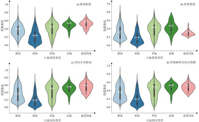
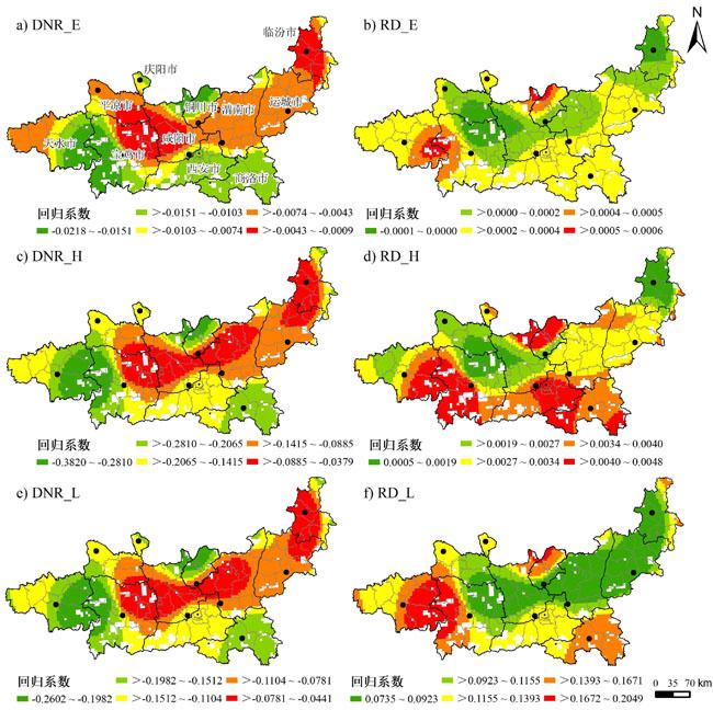
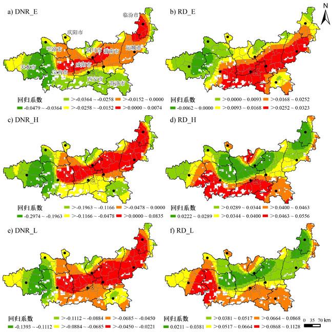
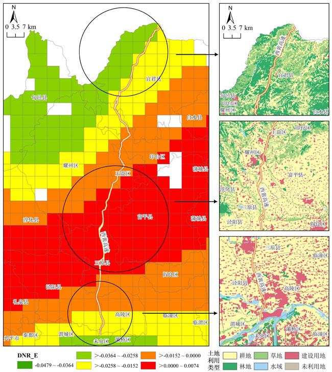
科学认知规模化道路建设对城市群地区景观破碎化的影响是协调交通建设与沿线生态环境,构建可持续生态交通基础设施体系的重要科学基础。文章选取高速交通网络快速扩张且位于黄河流域中游地区的关中平原城市群为研究区域,基于不同等级公路网和土地利用数据,引入兼顾变量非线性和空间非平稳性的地理神经网络加权回归模型,系统探讨了道路建设所引起的城市群土地利用景观破碎化的地理格局,并分析了不同道路对景观破碎化的影响及其空间差异。结果表明:1)相较于传统地理加权回归(GWR)和普通最小二乘回归(OLR)模型,文章所使用的GNNWR模型能更准确地揭示道路对景观破碎化的影响及其空间非平稳性。2)研究区景观破碎化呈现“核心―边缘”分异格局,景观破碎化整体处于较低水平,以低值和中低值区为主,平原城镇区低值集聚与山地生态区高值破碎形成显著空间对比。3)道路等级与破碎化强度呈正向关联,但高速公路因半封闭式管理影响程度有限;低等级道路对斑块维度和空间分布维度的景观破碎化影响最大,高等级道路则显著地影响着各个维度的景观破碎化。4)自然生态本底与人类活动强度的空间异质性导致道路廊道在生态屏障区、农业基质区和城镇扩展区分别形成差异化交通廊道与景观格局互动关系的“因时因地而异”的空间逻辑。
关键词: 道路网; 景观破碎化; 空间分异; 地理神经网络加权回归; 关中平原城市群
卢进发 , 李涛 , 邱孟龙 . 道路网对城市群土地利用景观破碎化的影响与空间分异[J]. 热带地理, 2025 , 45(8) : 1358 -1372 . DOI: 10.13284/j.cnki.rddl.20250069
Understanding the impact of large-scale road construction on landscape fragmentation in urban agglomerations provides a crucial scientific foundation for coordinating transportation development with the ecological environment and establishing sustainable eco-transportation infrastructure. This study focuses on the Guanzhong Plain Urban Agglomeration (GPUA), a rapidly developing urban cluster in the middle reaches of the Yellow River Basin that has experienced accelerated expansion of high-speed transportation networks. Building upon an analysis of landscape fragmentation patterns, we measured the differential impacts and spatial variations of various road types on fragmentation, offering new insights into the spatial complexity of road network disturbances in regional landscape patterns. Using 2020 highway network and land-use data from the GPUA, we implemented a Geographically Weighted Neural Network Regression (GNNWR) model to systematically investigate geographic patterns of road-induced landscape fragmentation while accounting for non-linear relationships and spatial non-stationarity. This approach further revealed how distinct road types contribute to fragmentation with varying spatial effects. The results demonstrated that, compared with traditional Geographically Weighted Regression and Ordinary Least Squares Regression models, the GNNWR model more accurately captured the influence of roads on landscape fragmentation and spatial heterogeneity. Landscape fragmentation across the study area exhibited a distinct core–periphery differentiation pattern, generally remaining at low levels dominated by low- and medium-low value zones, with striking spatial contrasts emerging between clustered low-fragmentation areas in urbanized plains and highly fragmented mountainous ecological zones. Road hierarchy showed a positive correlation with fragmentation intensity, though expressways exhibited limited impact due to semi-enclosed management systems. Low-grade roads had the most substantial influence on fragmentation in terms of patch dimension and spatial distribution dimension, while high-grade roads significantly affected fragmentation across all dimensions. Notably, the spatial heterogeneity in natural ecological baselines and intensity of human activity drove context-specific interactions between transportation corridors and landscape patterns. These dynamics established distinct spatiotemporal logics within ecological barrier zones, agricultural matrix areas, and urban expansion zones, where road networks interacted with local landscapes through geographically differentiated mechanisms.
表 1 数据来源Table 1 Data sources |
| 数据类型 | 内容 | 格式 | 年份 | 来源 |
|---|---|---|---|---|
| 道路数据 | 高速公路、一级公路、二级公路、 三级公路,其他道路等 | Shapefile(.shp) | 2020 | 开放街区地图(https://www.openstreetmap.org/) |
| 土地利用 数据 | 30 m分辨率,林地、耕地、 建设用地、草地和水域 | Raster(.tif) | 2020 | 中国科学院资源环境科学数据中心(http://www.resdc.cn/) |
| DEM | 30 m分辨率栅格 | Raster(.tif) | 2020 | 地理空间数据云(http://www.gscloud.cn/) |
| 人口 | 1 km分辨率栅格 | Raster(.tif) | 2020 | LandScan平台(https://landscan.ornl.gov/) |
| GDP | 1 km分辨率栅格 | Raster(.tif) | 2020 | 中国科学院资源环境科学数据中心(http://www.resdc.cn/) |
表 2 景观破碎化综合指数组成Table 2 Composition of landscape fragmentation index |
| 维度 | 指数 | 描述 | 方向 |
|---|---|---|---|
| 斑块规模 (0.25) | 斑块数量(0.667) | 斑块数量 | + |
| 最大斑块指数(0.333) | 最大面积斑块占区域 面积的比例 | - | |
| 斑块形状 (0.25) | 景观形状指数(0.333) | 斑块的形状复杂程度 | + |
| 面积加权形状 指数(0.667) | 各个斑块形状的复杂性,以面积为权重进行平均 | + | |
| 空间分布 (0.5) | 斑块密度 (0.167) | 每个区域单元内的斑块数量 | + |
| 聚集度指数(0.833) | 区域内某一景观的聚集程度 | - |
|
表3 解释变量基本统计Table 3 Basic statistics of explanatory variables |
| 影响因素 | 变量 | 单位 | 描述 | 最小值 | 均值 | 最大值 | 标准差 | VIF值 |
|---|---|---|---|---|---|---|---|---|
| 自然地理 | 起伏度(Relief) | m | 格网均值 | 1 | 168 | 672 | 133 | 5.82 |
| 海拔(DEM) | m | 格网均值 | 325 | 1 065 | 3 186 | 514 | 8.38 | |
| 社会经济 | 地区生产总值(GDP) | 万元 | 格网总值 | 0 | 828 | 154 222 | 4 701 | 3.98 |
| 人口(Pop) | 人 | 格网总值 | 0 | 10 214 | 973 637 | 30 008 | 4.73 | |
| 道路网络 | 到高等级道路距离(DNR_H) | m | 格网到最近高等级道路的平均最短距离 | 0 | 2 448 | 19 002 | 2 321 | 3.11 |
| 到低等级道路距离(DNR_L) | m | 格网到最近低等级道路的平均最短距离 | 0 | 1 756 | 18 497 | 1 684 | 2.58 | |
| 到高速公路距离(DNR_E) | m | 格网到最近高速公路的平均最短距离 | 240 | 10 598 | 67 651 | 9 900 | 3.38 | |
| 高等级道路密度(RD_H) | km/km² | 格网内高等级道路核密度 | 0 | 0.248 | 3.687 | 0.297 | 7.16 | |
| 低等级道路密度(RD_L) | km/km² | 格网内低等级道路核密度 | 0 | 0.389 | 6.503 | 0.543 | 5.02 | |
| 高速公路密度(RD_E) | km/km² | 格网内高速公路核密度 | 0 | 0.087 | 0.980 | 0.128 | 2.69 |
表 4 景观破碎化全局Moran's I 指数Table 4 Global Moran's I index of landscape fragmentation |
| 景观破碎化指数 | Moran's I | Z得分 | P值 |
|---|---|---|---|
| 综合指数 | 0.75 | 86.30 | 0.000* |
| 斑块维度 | 0.62 | 71.27 | 0.000* |
| 形状维度 | 0.73 | 83.86 | 0.000* |
| 空间分布维度 | 0.75 | 86.33 | 0.000* |
|
表 5 OLR、GWR、GNNWR模型对不同景观破碎化指数的建模结果Table 5 Different landscape fragmentation modeling results for OLR, GWR, and GNNWR models |
| 景观破碎化 指数 | OLR | GWR | GNNWR | |||||
|---|---|---|---|---|---|---|---|---|
| R² | RMSE | R² | RMSE | R² | RMSE | |||
| 综合指数 | 0.18 | 0.165 | 0.44 | 0.135 | 0.61 | 0.116 | ||
| 斑块维度 | 0.21 | 0.143 | 0.39 | 0.125 | 0.58 | 0.115 | ||
| 形状维度 | 0.15 | 0.156 | 0.42 | 0.128 | 0.58 | 0.109 | ||
| 空间分布维度 | 0.19 | 0.186 | 0.44 | 0.151 | 0.58 | 0.137 | ||
表6 GNNWR模型统计信息Table 6 Statistics of GNNWR model |
| 指标类型 | 到低等级道路距离 (DNR_L) | 到高等级道路距离 (DNR_H) | 到高速公路距离 (DNR_E) | 低等级道路密度 (RD_L) | 高等级道路密度 (RD_H) | 高速公路密度 (RD_E) | |
|---|---|---|---|---|---|---|---|
| 斑块 维度 | 1st四分位数 | -0.212 | -0.157 | -0.011 | 0.003 | 0.083 | 0.0002 |
| 中位数 | -0.156 | -0.120 | -0.007 | 0.003 | 0.118 | 0.0002 | |
| 3rd四分位数 | -0.090 | -0.080 | -0.005 | 0.004 | 0.142 | 0.0003 | |
| 平均值 | -0.161 | -0.124 | -0.008 | 0.003 | 0.118 | 0.0002 | |
| 形状 维度 | 1st四分位数 | 0.000 | -0.018 | -0.021 | 0.000 | -0.003 | -0.067 |
| 中位数 | 0.003 | 0.005 | -0.002 | 0.000 | 0.002 | -0.016 | |
| 3rd四分位数 | 0.005 | 0.038 | 0.020 | 0.001 | 0.005 | 0.010 | |
| 平均值 | 0.002 | 0.006 | -0.003 | 0.000 | 0.001 | -0.027 | |
| 空间 分布 维度 | 1st四分位数 | -0.113 | -0.151 | -0.036 | 0.116 | 0.086 | -0.004 |
| 中位数 | -0.076 | -0.089 | -0.022 | 0.123 | 0.099 | 0.019 | |
| 3rd四分位数 | -0.040 | 0.016 | 0.003 | 0.138 | 0.115 | 0.039 | |
| 平均值 | -0.081 | -0.083 | -0.019 | 0.127 | 0.101 | 0.020 | |
| 景观破碎化 综合指数 | 1st四分位数 | -0.085 | -0.135 | -0.030 | 0.043 | 0.030 | 0.008 |
| 中位数 | -0.061 | -0.078 | -0.021 | 0.059 | 0.036 | 0.017 | |
| 3rd四分位数 | -0.035 | 0.014 | -0.007 | 0.073 | 0.044 | 0.027 | |
| 平均值 | -0.065 | -0.073 | -0.019 | 0.060 | 0.037 | 0.017 | |
|
Ai J W, Yu K Y, Zeng Z, Yang L Q, Liu Y F, and Liu J. 2022. Assessing the Dynamic Landscape Ecological Risk and Its Driving Forces in an Island City Based on Optimal Spatial Scales: Haitan Island, China. Ecological Indicators, 137: 108771.
|
|
Ai S H, Liu Z Y, Ai X Y, Pan Y, and Ai Y W. 2024. China's Road Slopes Need Long-Term Protection. Science, 384(6699): 967-967.
|
|
Cai X J, Wu Z F, and Cheng J. 2013. Using Kernel Density Estimation to Assess the Spatial Pattern of Road Density and Its Impact on Landscape Fragmentation. International Journal of Geographical Information Science, 27(2): 222-230.
|
|
Che M L, Yang F, Sun J L, Zhang C, and Zhang J Y. 2023. Influence of Road Network Expansion on the Landscape Ecological Risk in the Yangtze River Delta Region over the Past Two Decades. Ecological Indicators, 156: 111178.
|
|
Chen S T, Di Marco M, Li B V, and Li Y R. 2024. Roadless Areas as an Effective Strategy for Protected Area Expansion: Evidence from China. One Earth, 7(8): 1456-1468.
|
|
Coffin A W. 2007. From Roadkill to Road Ecology: A Review of the Ecological Effects of Roads. Journal of Transport Geography, 15(5): 396-406.
|
|
戴特奇,郭凯菲,吴俊强,张丽丽. 2023. 西藏自治区公路建设对空间可达性和沿线景观破碎度的影响. 地理科学进展,42(10):1882-1890. [Dai Teqi, Guo Kaifei, Wu Junqiang, and Zhang Lili. 2023. Accessibility Improvement and Landscape Ecological Effect of Highway Development in Tibet. Progress in Geography, 42(10): 1882-1890. ]
|
|
Du Z H, Wang Z Y, Wu S S, Zhang F, and Liu R Y. 2020. Geographically Neural Network Weighted Regression for the Accurate Estimation of Spatial Non-Stationarity. International Journal of Geographical Information Science, 34(7): 1353-1377.
|
|
Eroglu E, Acar C, and Meral A. 2018. Ecological and Visual Characteristics of Native Plant Compositions in Mountain Forests. Fresenius Environmental Bulletin, 27(4): 2160-2172.
|
|
Forman R T T and Alexander L E. 1998. Roads and Their Major Ecological Effects. Annual Review of Ecology, Evolution, Systematics, 29: 207-231.
|
|
黄梦娜,马廷. 2019. 中国道路网引起的景观破碎格局及其对保护区的影响. 地球信息科学学报,21(8):1183-1195. [Huang Mengna and Ma Ting. 2019. Assessing the Impacts of China's Road Network on Landscape Fragmentation and Protected Areas. Journal of Geo-information Science, 21(8): 1183-1195. ]
|
|
Huijser M P, Fairbank E R, Camel-Means W, Graham J, Watson V, Basting P, and Becker D. 2016. Effectiveness of Short Sections of Wildlife Fencing and Crossing Structures along Highways in Reducing Wildlife-Vehicle Collisions and Providing Safe Crossing Opportunities for Large Mammals. Biological Conservation, 197: 61-68.
|
|
Ibisch P L, Hoffmann M T, Kreft S, Pe'er G, Kati V, Biber-Freudenberger L, DellaSala D A, Vale M M, Hobson P R, and Selva N. 2016. A Global Map of Roadless Areas and Their Conservation Status. Science, 354(6318): 1423-1427.
|
|
李倩雯,靳甜甜,蒋爱萍,彭期冬,林俊强,张迪. 2023. 道路建设对西南地区景观格局的影响. 生态学报,43(6):2310-2322. [Li Qianwen, Jin Tiantian, Jiang Aiping, Peng Qidong, Lin Junqiang, and Zhang Di. 2023. Effects of Road Construction on Landscape Pattern in Southwest China. Acta Ecologica Sinica, 43(6): 2310-2322. ]
|
|
李双成,许月卿,周巧富,王磊. 2004. 中国道路网与生态系统破碎化关系统计分析. 地理科学进展,23(5):78-85,110. [Li Shuangcheng, Xu Yueqing, Zhou Qiaofu, and Wang Lei. 2004. Statistical Analysis on the Relationship Between Road Network and Ecosystem Fragmentation in China. Progress in Geography, 23(5): 78-85, 110. ]
|
|
李涛,高毅华,王姣娥. 2025. 西成高铁(陕西段)沿线土地利用和景观格局变化的梯度效应. 生态学报,45(4):1-17. [Li Tao, Gao Yihua, and Wang Jiao'e. 2025. Gradient Effect of Changes in Land Use and Landscape Patterns along the Xi'an⁃Chengdu High⁃Speed Railway Line (Shaanxi Segment). Acta Ecologica Sinica, 45(4): 1-17. ]
|
|
Lin Y Y, Hu X S, Zheng X X, Hou X Y, Zhang Z X, Zhou X N, Qiu R Z, and Lin J G. 2019. Spatial Variations in the Relationships between Road Network and Landscape Ecological Risks in the Highest Forest Coverage Region of China. Ecological Indicators, 96: 392-403.
|
|
Lisiak-Zielińska M, Borowiak K, and Budka A. 2022. How Big Is the Real Road-Effect Zone? The Impact of the Highway on the Landscape Structure—A Case Study. Sustainability, 14(22): 15219.
|
|
Liu C H, Wu S S, Dai Z, Wang Y Y, Du Z H, Liu X Y, and Qiu C X. 2023. High-Resolution Daily Spatiotemporal Distribution and Evaluation of Ground-Level Nitrogen Dioxide Concentration in the Beijing-Tianjin-Hebei Region Based on TROPOMI Data. Remote Sensing, 15(15): 3878.
|
|
刘世梁,温敏霞,崔保山,富伟,杨敏. 2008. 道路影响域的界定及其空间分异规律——以纵向岭谷区为例. 地理科学进展,27(5):122-128. [Liu Shiliang, Wen Minxia, Cui Baoshan, Fu Wei, and Yang Min. 2008. Definition and Spatial Differentiation of Road-Effect Zone: A Case Study in Longitudinal Range-Gorge Region. Progress in Geography, 27(5): 122-128. ]
|
|
刘世梁,刘琦,王聪,赵清贺,邓丽,董世魁. 2014. 基于地理加权回归的漫湾库区景观破碎化及影响因子分析. 地理科学,34(7):856-862. [Liu Shiliang, Liu Qi, Wang Cong, Zhao Qinghe, Deng Li, and Dong Shikui. 2014. Landscape Fragmentation and Affecting Factors of Manwan Reservoir Based on Geographically Weighted Regression. Scientia Geographica Sinica, 34(7): 856-862. ]
|
|
刘栩成,尹小玲,黄光庆,陈彩霞. 2020. 基于GWR模型的道路对景观破碎化影响研究. 生态科学,39(6):120-126. [Liu Xucheng, Yin Xiaoling, Huang Guangqing, and Chen Caixia. 2020. Impacts of Roads on Landscape Fragmentation Based on GWR Model. Ecological Science, 39(6): 120-126. ]
|
|
Miao Y, Dai T Q, Yang X D, and Song J P. 2021. Landscape Fragmentation Associated with the Qingzang Highway and Its Influencing Factors—A Comparison Study on Road Sections and Buffers. Geography and Sustainability, 2(1): 59-67.
|
|
Mo W B, Wang Y, Zhang Y X, and Zhuang D F. 2017. Impacts of Road Network Expansion on Landscape Ecological Risk in a Megacity, China: A Case Study of Beijing. Science of the Total Environment, 574: 1000-1011.
|
|
Shi H, Shi T G, Yang Z P, Wang Z, Han F, and Wang C R. 2018. Effect of Roads on Ecological Corridors Used for Wildlife Movement in a Natural Heritage Site. Sustainability, 10(8): 2725.
|
|
孙国庆,邹滨,姜晓璐,邱永红. 2017. 公路走廊带景观破碎度的空间分异研究. 测绘与空间地理信息,40(8):106-109. [Sun Guoqing, Zou Bin, Jiang Xiaolu, and Qiu Yonghong. 2017. Spatial Heterogeneity of Landscape Fragmentation in Road Corridor. Geomatics & Spatial Information Technology, 40(8): 106-109. ]
|
|
吴森森,丁佳乐,严成,陈奕君,杜震洪. 2024. 基于TD-GNNWR的武汉市房价因子空间非平稳性研究. 地理学报,79(8):1961-1977.
Wu Sensen, Ding Jiale, Yan Cheng, Chen Yijun, and Du Zhenhong. 2024. Spatial Non-Stationarity Assessments of Housing Prices in Wuhan Based on a TD-GNNWR Model. Acta Geographica Sinica, 79(8): 1961-1977.
|
|
许尔琪. 2017. 基于地理加权回归的石漠化影响因子分布研究. 资源科学,39(10):1975-1988. [Xu Erqi. 2017. Spatial Variation in Drivers of Karst Rocky Desertification Based on Geographically Weighted Regression Model. Resources Science, 39(10): 1975-1988. ]
|
|
Xu M Y, Niu L, Wang X B, and Zhang Z F. 2023. Evolution of Farmland Landscape Fragmentation and Its Driving Factors in the Beijing-Tianjin-Hebei Region. Journal of Cleaner Production, 418: 138031.
|
|
Yang S Q, Jin Z, Luo D, and Feng L. 2023. Road Network Expansion and Its Impact on Landscape Patterns in the Dongzhi Tableland of the Chinese Loess Plateau. Journal of Geographical Sciences, 33(12): 2549-2566.
|
|
杨思琪,朱高儒,刘杰,徐洪磊. 2022. “格局-过程-功能”视角下交通生态效应研究进展. 生态环境学报,31(3):634-642. [Yang Siqi, Zhu Gaoru, Liu Jie, and Xu Hongle. 2022. The Research Progress of the Traffic Ecological Effects under the Perspective of "Pattern-Process-Function". Ecology and Environmental Sciences, 31(3): 634-642. ]
|
|
张童,姚士谋,胡伟平,崔锋艳. 2018. 基于交通可达性的广佛都市区城市扩展的模拟与分析. 地理科学,38(5):737-746.
Zhang Tong, Yao Shimou, Hu Weiping, and Cui Fengyan. 2018. Simulation of Urban Expansion in Guangzhou-Foshan Metropolitan Area Under the Influence of Accessibility. Scientia Geographica Sinica, 38(5): 737-746.
|
|
赵芳,卢涛. 2017. 道路扩展对青藏高原东缘土地利用及景观格局的影响. 生态科学,36(4):146-151. [Zhao Fang and Lu Tao. 2017. Ecological Effects of Roads on Land Use and Landscape Pattern in Eastern Tibetan Plateau, China. Ecological Science, 36(4): 146-151. ]
|
|
Zhu M, Xu J G, Jiang N, Li J L, and Fan Y M. 2006. Impacts of Road Corridors on Urban Landscape Pattern: A Gradient Analysis with Changing Grain Size in Shanghai, China. Landscape Ecology, 21(5): 723-734.
|
|
中华人民共和国国家发展与改革委员会. 2018. 关中平原城市群发展规划.(2018-02-02)[2025-08-17]. https://baike.baidu.com/reference/22378134/533aYdO6cr3_z3kATKfazqn1ZiaVZYn6t7bSA-NzzqIP0XOpX5nyFIY28tRx-fhxWgjF_4JhZtRajOusWA8P8fUQcOU1QKpmn3b-WzPAybmJ9943k9FAvdIHBfE.
National Development and Reform Commission of the People's Republic of China. 2018. Development Plan for the Guanzhong Plain Urban Agglomeration. (2018-02-02) [2025-08-17]. https://baike.baidu.com/reference/22378134/533aYdO6cr3_z3kATKfazqn1Zia VZYn6t7bSA-NzzqIP0XOpX5nyFIY28tRx-fhxWgjF_4JhZtRajO usWA8P8fUQcOU1QKpmn3b-WzPAybmJ9943k9FAvdIHBfE.
|
|
中华人民共和国国家发展与改革委员会,中华人民共和国交通运输部. 2022. 国家公路网规划(2022—2035年).(2022-07-04) [2025-08-17]. https://xxgk.mot.gov.cn/2020/jigou/zhghs/202207/P020220721337323849487.pdf.
National Development and Reform Commission of the People's Republic of China and Ministry of Transport of the People's Republic of China. 2022. National Highway Network Plan(2022-2035). (2022-07-04) [2025-08-17]. https://xxgk.mot.gov.cn/2020/jigou/zhghs/202207/P020220721337323849487.pdf.
|
|
宗跃光,周尚意,彭萍,刘超,郭瑞华,陈红春. 2003. 道路生态学研究进展. 生态学报,(11):2396-2405. [Zong Yueguang, Zhou Shangyi, Peng Ping, Liu Chao, Guo Ruihua, and Chen Hongchun. 2003. Perspective of Road Ecology Development. Acta Ecologica Sinica, (11): 2396-2405. ]
|
/
| 〈 |
|
〉 |