
河网区潮流顶托对滨海城市内涝影响——以珠海金凤—翠屏片区为例
参与模型构建、参数校准与验证工作
|
潘骆颖(2001—),女,湖北孝感人,硕士研究生,研究方向为城市内涝模拟,E-mail:panly26@mail2.sysu.edu.cn |
收稿日期: 2025-09-10
修回日期: 2025-12-16
网络出版日期: 2026-03-07
基金资助
国家重点研发计划项目(2021YFC3001000);国家自然科学基金项目(U1911204);珠海市洪潮涝遭遇水情监测预报与群闸排涝优化调度研究(SML2023SP213)
版权
Impact of Tidal Backwater in a River-Network Region on Urban Waterlogging in a Coastal City: A Case Study of the Jinfeng-Cuiping Area, Zhuhai
Received date: 2025-09-10
Revised date: 2025-12-16
Online published: 2026-03-07
Copyright
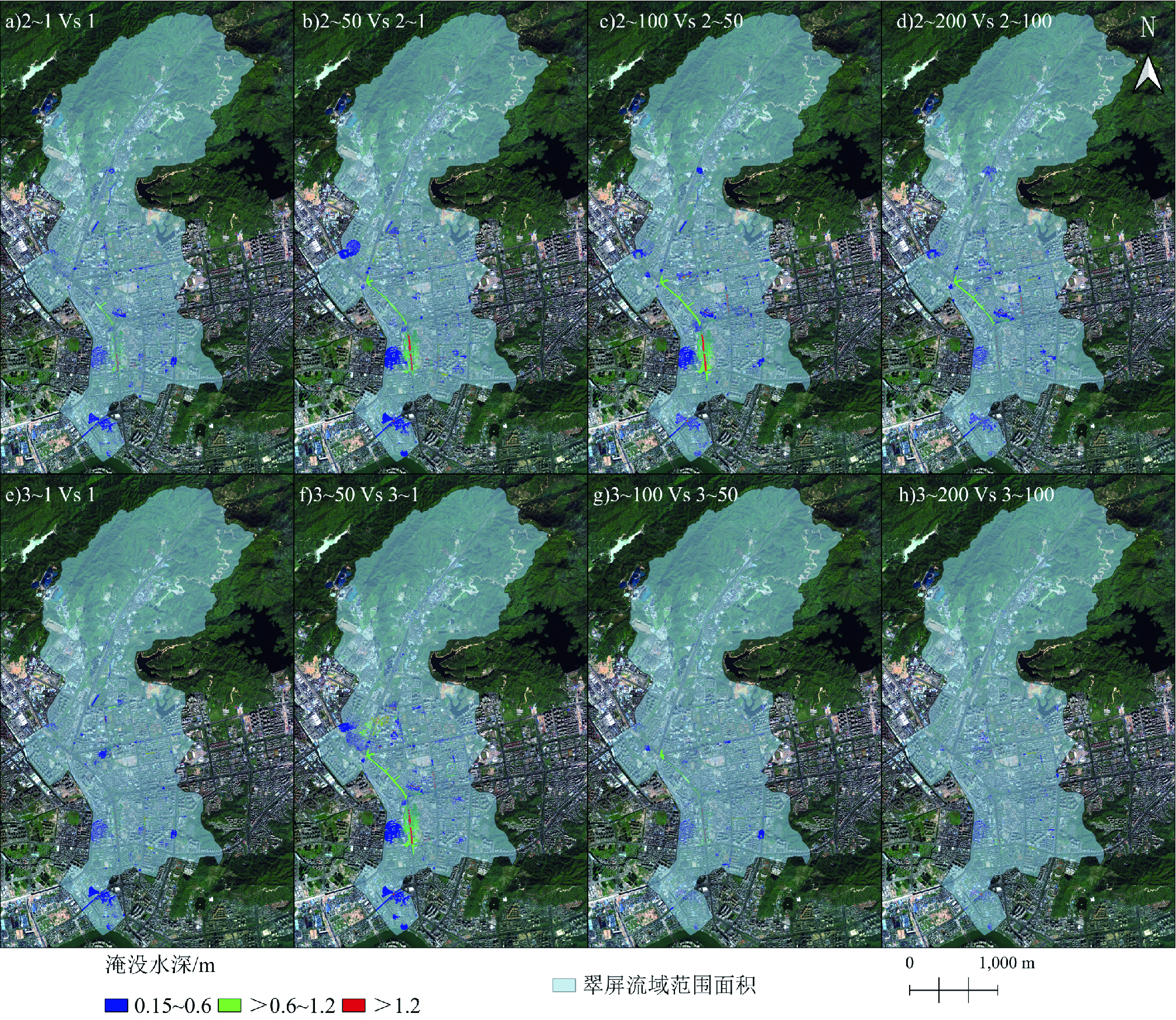
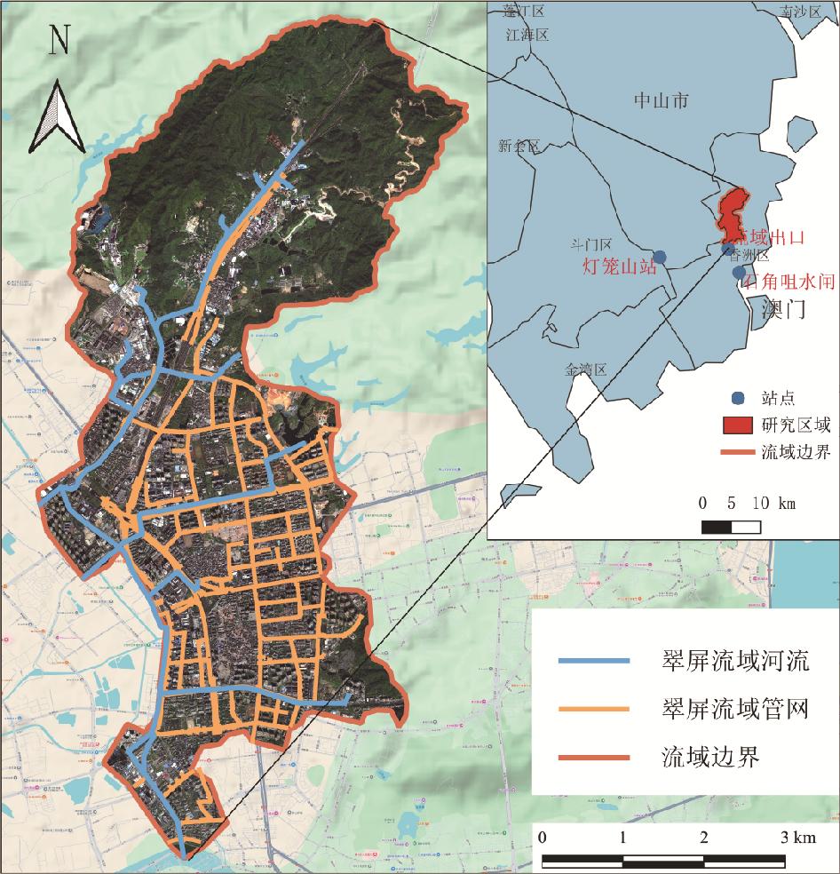
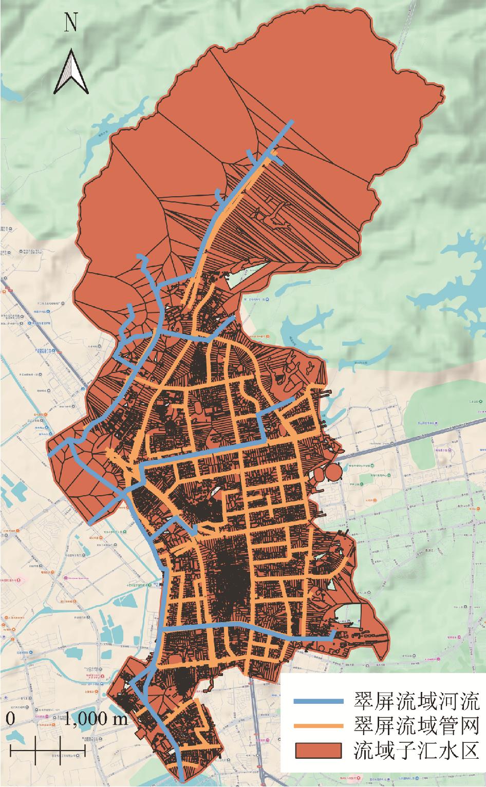
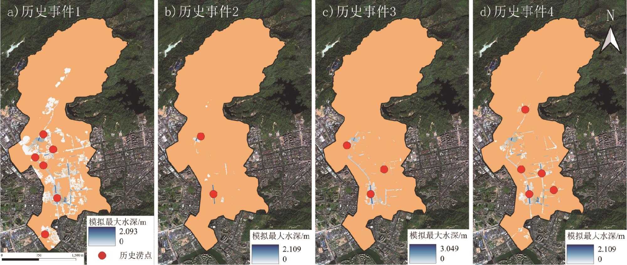
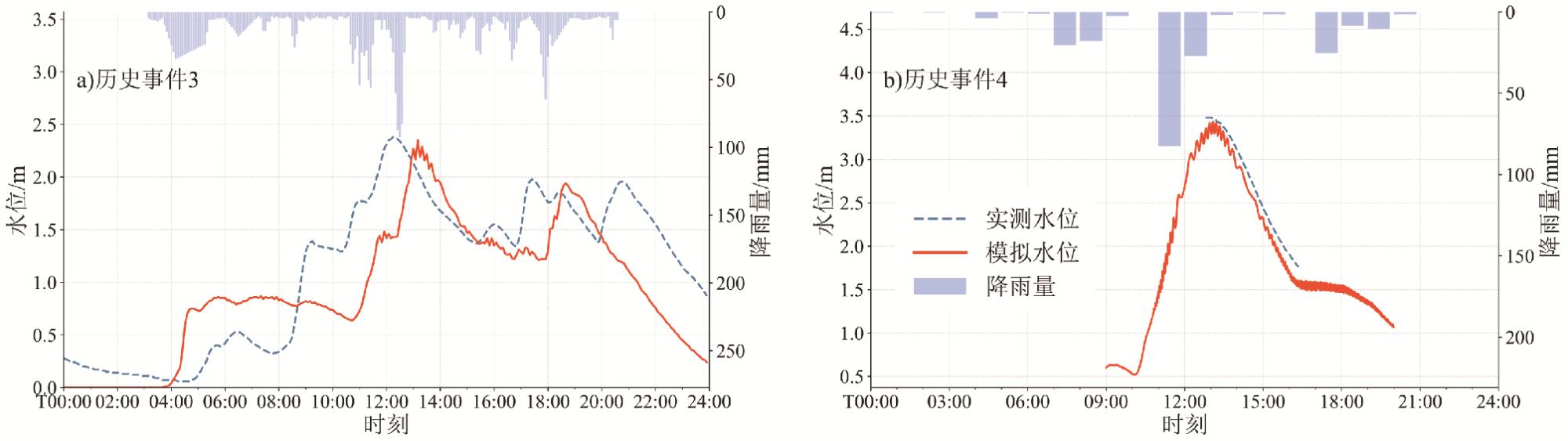
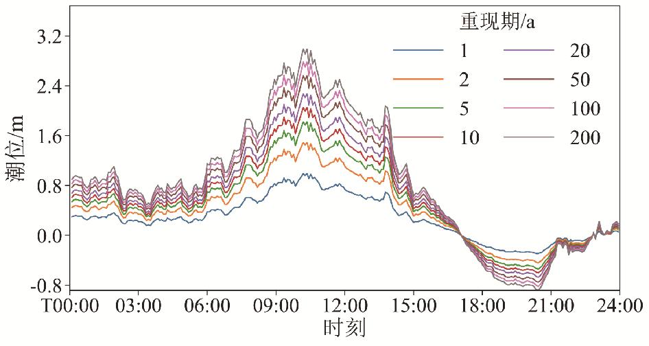
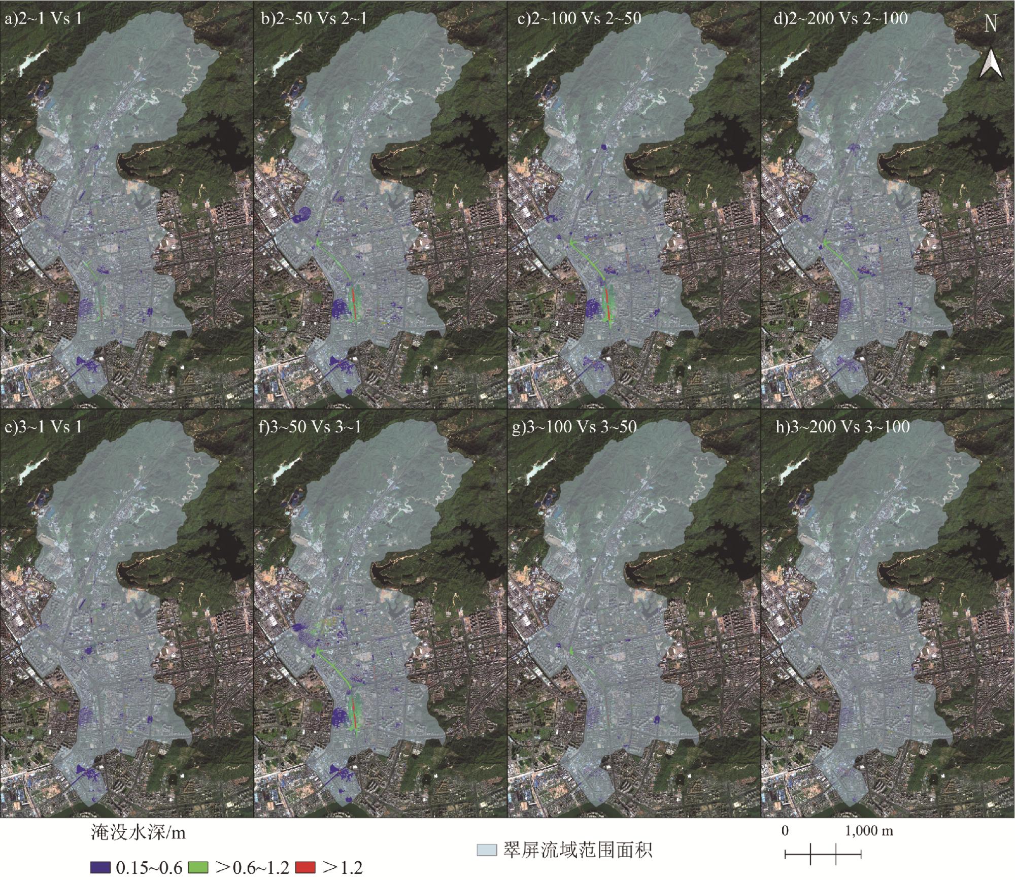
以珠海市金凤—翠屏片区为研究区,采用最大熵方法拟合潮位频率分布,并基于潮位相关性实现设计潮位由灯笼山站向石角咀闸的映射迁移;在此基础上构建SWMM与LISFLOOD-FP松散耦合的一维−二维模拟框架,设置“降雨−潮位−闸控”多情景开展滨海城市内涝响应分析。结果显示:1)在2024-05-04强降雨无闸控条件下,自由出流情景溢流节点占比为43.46%,在200 a潮位情景下升至46.35%,高满流管段比例达到52.41%,排水系统呈明显超载;2)潮位顶托显著放大内涝风险,200 a情景最大淹没水深增至2.85 m(较自由出流增加约40%),总淹没面积扩大至3.62 km2(增加129%),高风险区面积增加约39%;3)分级闸控可有效削减极端潮位下的峰值淹没风险,在200 a情景下,流域出口下游边界采用分闸门调控可使最大淹没水深降低26.18%,总淹没面积由3.62降至3.0 km2(减少17.1%),但对溢流历时与系统性超载的改善相对有限。研究表明,潮位顶托是滨海城市内涝的重要放大机制,科学闸控运行可在极端条件下发挥削峰与减灾作用。
关键词: 潮位顶托; 河网区; 内涝模拟; "降雨−潮位–闸控"情景; SWMM–LISFLOOD-FP耦合模型; 最大熵算法; 珠海市
潘骆颖 , 陈晓宏 , 张瓅丹 , 孙伊贝 . 河网区潮流顶托对滨海城市内涝影响——以珠海金凤—翠屏片区为例[J]. 热带地理, 2026 , 46(3) : 458 -470 . DOI: 10.13284/j.cnki.rddl.20250610
Coastal cities are increasingly exposed to compound pluvial-coastal flooding under climate change and sea-level rise. When intense rainfall coincides with elevated downstream water levels, tide-induced backwaters suppress gravity drainage and can rapidly escalate sewer surcharges and surface inundation. This study quantifies the amplification effect of tidal backwater on urban waterlogging in a tidal river-network system and evaluates the mitigation potential of graded sluice operation under extreme conditions. The Jinfeng-Cuiping area in Zhuhai, southern China, was selected as a representative low-gradient coastal catchment. A designed tide frequency curve was derived using a maximum entropy framework and fitted with multiple candidate probability distributions. The goodness-of-fit was evaluated using the Kolmogorov-Smirnov (K-S) test, and the selected distribution was used to obtain the design high-tide levels for typical return periods. Because long-term observations at the target downstream boundary (Shijiaozui sluice) are limited, design tide levels were transferred from the long-record Denglongshan gauge to Shijiaozui through an empirically established relationship based on overlapping water-level observations, thereby enabling long-series-based boundary design while maintaining local representativeness. A loosely coupled 1D-2D urban flood model was then built by linking the U.S. EPA Storm Water Management Model (SWMM) for drainage hydraulics with LISFLOOD-FP for surface inundation. The SWMM-simulated node overflow hydrographs were converted into boundary-condition files and imposed on the corresponding grid cells in the 2D model to reproduce the spatiotemporal evolution of surface flooding. The coupled workflow was calibrated and validated against multiple historical waterlogging events using both inundation extent and water-level processes, ensuring that the model can be used for mechanism identification and scenario comparison. Scenario simulations were conducted for the heavy rainfall event of 4 May 2024 under three classes of downstream boundary conditions: (i) free outflow (no tidal constraint), (ii) rainfall encountering 1-, 10-, 50-, 100-, and 200-year design tides with direct imposition of tide levels at the downstream boundary, and (iii) the same tide scenarios with graded sluice operation driven by the head difference between the inside and outside water levels. Key response metrics included overflow-node count and proportion, overflow duration and depth indicators, sewer surcharge classification, and inundation depth/area statistics. Results indicate that tidal backwater substantially increases system overload and surface waterlogging. Under the 4 May 2024 rainfall, the overflow-node proportion reached 43.46% in the free-outflow case and increased to 46.35% under the 200-year tide, with the proportion of highly surcharged pipes increasing to 52.41%, indicating severe drainage stress. The tide backwater also amplified surface flooding, with the maximum inundation depth increasing to 2.85 m (approximately 40% higher than free outflow) and the total inundation area expanding to 3.62 km2 (129% larger than free outflow). Graded sluice operation provided measurable peak-reduction benefits in the 200-year tide scenario: compared with directly imposing tide levels as the downstream boundary, the maximum inundation depth decreased by 20.7%-26.2%, the total inundation area was reduced from 3.62 km2 to 3.0 km2 (a 17.1% reduction), and the high-risk zone area decreased by 13.5%, although improvements in overflow duration and system-wide surcharge conditions remained limited. Overall, downstream tide levels are confirmed as a dominant external amplifier of pluvial waterlogging in coastal river-network cities, and tide-aware sluice operation provides a practical avenue for peak reduction and disaster mitigation under extreme compound conditions. The proposed design-tide-to-model workflow supports tide-aware drainage assessments, sluice operation designs, and compound flood risk management in similar coastal urban settings.
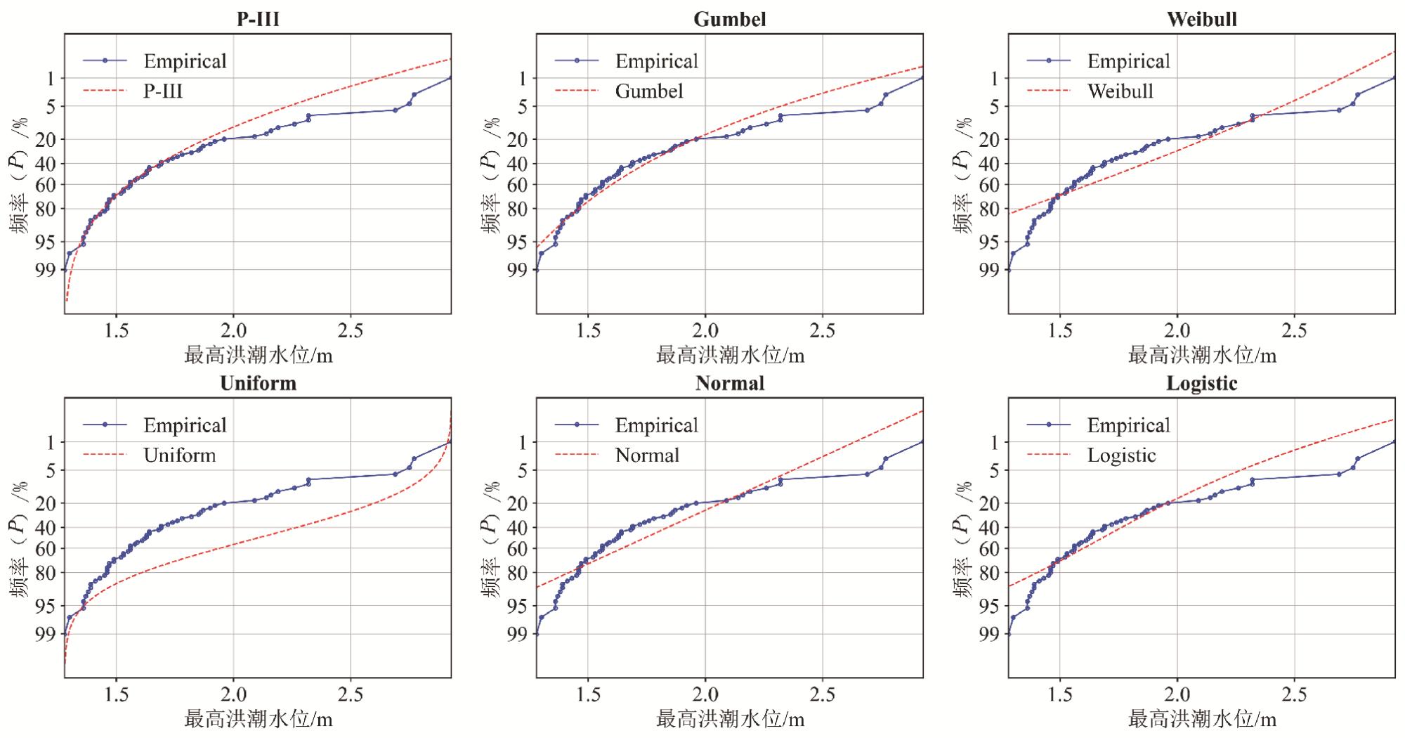
表1 六种概率密度函数参数Table 1 Parameters of six probability density functions |
| 概率密度函数 | 尺度参数 | 形状参数 | 位置参数 |
| Pearson-Ⅲ型 | 0.299 6 | 1.573 2 | 1.270 5 |
| Gumbel型 | 0.250 4 | — | 1.579 9 |
| Weibull型 | 1.900 1 | 4.332 | — |
| Uniform型 | 1.28(下界) | 2.93(上界) | — |
| Normal型 | — | 0.384 3 | 1.741 9 |
| Logistic型 | 0.200 4 | — | 1.680 9 |
表2 6种概率密度分布函数KS检验P值Table 2 KS test statistics of six probability density distribution functions |
| 分布函数 | KS检验P值 |
| Pearson-Ⅲ型 | 0.854 541 |
| Gumbel型 | 0.412 726 |
| Weibull型 | 0.050 700 |
| Uniform型 | 0.000 000 |
| Normal型 | 0.051 676 |
| Logistic型 | 0.232 367 |
表3 模型主要参数取值范围及率定结果Table 3 Ranges of the main model parameters and calibration results |
| 土地类型 | N(曼宁系数) | f0(初始下渗率) | fc(稳定下渗率) | β(下渗衰退系数) | ||||||||
| 率定结果 | 取值范围 | 率定结果 | 取值范围/(mm·h-1) | 率定结果 | 取值范围/(mm·h-1) | 率定结果 | 取值范围 | |||||
| 道路 | 0.015 | 0.01~0.02 | 60 | 50~100 | 10 | 5~15 | 1 | 0.800~1.085 | ||||
| 树木覆盖 | 0.600 | 0.50~0.70 | 100 | 80~100 | 10 | 5~15 | 1 | 0.832~1.085 | ||||
| 灌木地 | 0.400 | 0.50~0.70 | 100 | 80~100 | 10 | 5~15 | 1 | 0.832~1.085 | ||||
| 草地 | 0.300 | 0.28~0.40 | 100 | 80~100 | 10 | 5~15 | 1 | 0.832~1.085 | ||||
| 农田 | 0.300 | 0.28~0.40 | 100 | 80~100 | 10 | 5~15 | 1 | 0.832~1.085 | ||||
| 建筑 | 0.050 | 0.04~0.07 | 100 | 50~100 | 1 | 0.1~1 | 1 | 0.832~1.085 | ||||
| 稀疏植被 | 0.300 | 0.20~0.40 | 100 | 50~100 | 10 | 1~10 | 1 | 0.832~1.085 | ||||
| 水体 | 0.030 | 0.02~0.04 | 10 | 5~15 | 5 | 1~10 | 1 | 0.832~1.085 | ||||
| 湿地 | 0.300 | 0.25~0.45 | 60 | 50~100 | 10 | 5~15 | 1 | 0.832~1.085 | ||||
表4 灯笼山站与石角咀闸设计潮位Table 4 Design tide levels at Denglongshan station and Shijiaozui sluice |
| 重现期/a | 潮位/m | |
| 灯笼山站 | 石角咀闸 | |
| 1 | 1.270 5 | 1.131 5 |
| 10 | 2.242 0 | 2.047 0 |
| 50 | 2.786 6 | 2.560 3 |
| 100 | 3.015 0 | 2.775 5 |
| 200 | 3.240 9 | 2.988 5 |
表5 节点溢流情况统计Table 5 Statistics of node overflow |
| 设计情景 | 重现期/a | 溢流节点 | 时长高于 0.5 h/个 | 深度> 0.5 m/个 | 溢流开始 时间 | |
| 数量/个 | 占比/% | |||||
| 情景一 | 自由出流 | 977 | 43.46 | 552 | 189 | T 11:02 |
| 情景二 | 1 | 1 012 | 45.01 | 572 | 208 | T 11:02 |
| 10 | 1 019 | 45.33 | 587 | 226 | T 11:02 | |
| 50 | 1 027 | 45.69 | 599 | 235 | T 11:02 | |
| 100 | 1 030 | 45.82 | 606 | 242 | T 11:02 | |
| 200 | 1 042 | 46.35 | 615 | 250 | T 11:02 | |
| 情景三 | 1 | 1 006 | 44.75 | 567 | 198 | T 11:02 |
| 10 | 1 013 | 45.06 | 573 | 203 | T 11:02 | |
| 50 | 1 019 | 45.33 | 585 | 211 | T 11:02 | |
| 100 | 1 024 | 45.55 | 592 | 223 | T 11:02 | |
| 200 | 1 030 | 45.82 | 607 | 231 | T 11:02 | |
表6 管道满流情况分级统计Table 6 Classification statistics of pipeline surcharge conditions |
| 设计 情景 | 重现期/a | 满流分级 | 满流时长>0.5 h | ||
| (0,0.5)(低) | [0.5,0.8)(中) | [0.8,1](高) | |||
| 情景一 | 自由出流 | 634 | 322 | 1 131 | 501 |
| 情景二 | 1 | 656 | 353 | 1 143 | 527 |
| 10 | 667 | 362 | 1 159 | 531 | |
| 50 | 672 | 379 | 1 168 | 538 | |
| 100 | 683 | 380 | 1 175 | 551 | |
| 200 | 690 | 387 | 1 186 | 559 | |
| 情景三 | 1 | 653 | 338 | 1 141 | 515 |
| 10 | 664 | 345 | 1 153 | 521 | |
| 50 | 673 | 357 | 1 167 | 533 | |
| 100 | 679 | 363 | 1 172 | 541 | |
| 200 | 685 | 379 | 1 181 | 549 | |
表7 不同情景下的淹没统计Table 7 Inundation statistics under different scenarios |
| 设计情景 | 重现期/a | 最大淹没 水深/m | 淹没面积/km2 | ||
| [0.15, 0.6] m | (0.6, 1.2] m | (1.2, ∞)m | |||
| 情景一 | 自由出流 | 2.034 | 1.017 4 | 0.464 1 | 0.102 5 |
| 情景二 | 1 | 2.717 | 1.226 7 | 0.506 7 | 0.106 6 |
| 10 | 2.704 | 1.614 5 | 0.580 1 | 0.115 9 | |
| 50 | 2.78 | 2.000 1 | 0.660 6 | 0.126 0 | |
| 100 | 2.761 | 2.486 5 | 0.742 4 | 0.141 0 | |
| 200 | 2.848 | 2.688 2 | 0.787 0 | 0.142 5 | |
| 情景三 | 1 | 2.126 | 1.192 4 | 0.490 2 | 0.103 7 |
| 10 | 2.261 | 1.683 7 | 0.590 4 | 0.110 3 | |
| 50 | 2.216 | 1.920 7 | 0.659 2 | 0.118 1 | |
| 100 | 2.252 | 2.032 5 | 0.675 9 | 0.121 5 | |
| 200 | 2.257 | 2.083 7 | 0.694 3 | 0.122 5 | |
|
Chang T Y, Chen H, Fu H S, Chen W B, Yu Y C, Su W R, and Lin L Y. An Operational High-Performance Forecasting System for City-Scale Pluvial Flash Floods in the Southwestern Plain Areas of Taiwan. Water, 2021, 13 (4): 405.
|
|
Chen J, Hill A A, and Urbano L D. A GIS-Based Model for Urban Flood Inundation. Journal of Hydrology, 2009, 373 (1): 184- 192.
|
|
丁洁晨. 2024. 基于雨潮遭遇情景的沿海城市内涝模拟及风险评估研究. 西安: 长安大学.
Ding Jiechen. 2024. Modeling and Risk Assessment of Coastal Urban Flooding Based on Combined Rainfall and Tide Scenarios. Xi'an: Chang'an University.
|
|
广州市水务局, 广州市水务工程技术中心. 2021. 广州市海绵城市建设——洪涝安全评估技术指引. (2024-10-01)[2026-02-05]. https://swj.gz.gov.cn/attachment/7/7722/7722042/9983905.pdf.
Guangzhou Municipal Water Affairs Bureau, and Guangzhou Water Affairs Engineering Technology Center. 2021. Technical Guideline for Sponge City Construction in Guangzhou: Flood Safety Assessment. (2024-10-01) [2026-02-05]. https://swj.gz.gov.cn/attachment/7/7722/7722042/9983905.pdf.
|
|
Javan K, Banihashemi S, Nazari A, Roozbahani A, Darestani M, and Hossieni H. Coupled SWMM-MOEA/D for Multi-Objective Optimization of Low Impact Development in Urban Stormwater Systems. Journal of Hydrology, 2025, 656, 133044.
|
|
Karimi N, Sheshangosht S, Rashtbari M, Torabi O, Sarbazvatan A, Lari M, Aminzadeh H, Abolhoseini S, and Eftekhari M. An Advanced High Resolution Land Use/Land Cover Dataset for Iran (ILULC-2022) by Focusing on Agricultural Areas Based on Remote Sensing Data. Computers and Electronics in Agriculture, 2025, 228, 109677.
|
|
李路, 宫辉力, 郭琳, 朱琳, 陈蓓蓓. 水文时间序列分析方法研究进展. 地球信息科学学报, 2024, 26 (4): 927- 945.
Li Lu, Gong Huili, Guo Lin, Zhu Lin, and Chen Beibei. Research Advances on Hydrologic Time Series Analysis Methods. Journal of Geo-information Science, 2024, 26 (4): 927- 945.
|
|
刘爱丽. 2024. 城市洪涝模拟模型构建及其应用研究——以北京市凉水河流域为例. 郑州: 华北水利水电大学.
Liu Aili. 2024. Research on the Construction and Application of Urban Flood Simulation Model: Taking the Liangshui River Basin in Beijing as an Example. Zhengzhou: North China University of Water Resources and Electric Power.
|
|
Liu Q, Xu H, and Wang J. Assessing Tropical Cyclone Compound Flood Risk Using Hydrodynamic Modelling: A Case Study in Haikou City, China. Natural Hazards and Earth System Sciences, 2022, 22 (2): 665- 675.
|
|
刘青, 吴国凤, 姚前, 许瀚卿, 牛怡莹, 魏旭辰, 王军, 李梦雅. 气候变化下沿海城市极端复合洪涝灾害危险性预估——以海口市为例. 热带地理, 2025, 45 (4): 527- 539.
Liu Qing, Wu Guofeng, Yao Qian, Xu Hanqing, Niu Yiying, Wei Xuchen, Wang Jun, and Li Mengya. Hazard Assessment of Extreme Compound Flood Hazards in Coastal Cities under Climate Change: A Case Study of Haikou City. Tropical Geography, 2025, 45 (4): 527- 539.
|
|
马杰. 2018. 基于最大熵原理的平原水库波高分布研究. 济南: 山东大学.
Ma Jie. 2018. Research on the Distribution of Wave Height in Plain Reservoir Based on Principle of Maximum Entropy. Jinan: Shandong University.
|
|
Santiago-Collazo F L, Bilskie M V, and Hagen S C. A Comprehensive Review of Compound Inundation Models in Low-Gradient Coastal Watersheds. Environmental Modelling & Software, 2019, 119, 166- 181.
|
|
Shi S, Yang B, and Jiang W. Numerical Simulations of Compound Flooding Caused by Storm Surge and Heavy Rain with the Presence of Urban Drainage System, Coastal Dam and Tide Gates: A Case Study of Xiangshan, China. Coastal Engineering, 2022, 172, 104064.
|
|
汪海航, 李帆, 吴兴祥, 秦志琼, 孟萌, 蒋晓蕾. 基于Copula函数的区域雨潮遭遇风险概率分析. 中国水利水电科学研究院学报(中英文), 2024, 22 (4): 425- 435.
Wang Haihang, Li Fan, Wu Xingxiang, Qin Zhiqiong, Meng Meng, and Jiang Xiaolei. Research on the Joint Probability of Rainstorm and Tidal Level Based on the Copula Function. Journal of China Institute of Water Resources and Hydropower Research, 2024, 22 (4): 425- 435.
|
|
王尚伟. 2023. 中珠联围雨潮遭遇风险概率及内涝灾害危险性分析. 广州: 华南理工大学.
Wang Shangwei. 2023. Encounter Risk of Rainstorm and Tide Level and Waterlogging Hazard Analysis in Zhong-Zhu Catchment Area. Guangzhou: South China University of Technology.
|
|
徐卫红, 李娜, 王艳艳, 王静, 俞茜. 基于城市洪涝仿真模型的天津中心城区内涝特征分析. 水利水电技术(中英文), 2022, 53 (6): 20- 33.
Xu Weihong, Li Na, Wang Yanyan, Wang Jing, and Yu Qian. Urban Flood-Waterlogging Simulation Model-Based Analysis on Waterlogging Characteristics of Central Urban Area of Tianjin. Water Resources and Hydropower Engineering, 2022, 53 (6): 20- 33.
|
|
曾照洋, 王兆礼, 吴旭树, 赖成光, 陈晓宏. 基于SWMM和LISFLOOD模型的暴雨内涝模拟研究. 水力发电学报, 2017, 36 (5): 68- 77.
Zeng Zhaoyang, Wang Zhaoli, Wu Xushu, Lai Chengguang, and Chen Xiaohong. Rainstorm Waterlogging Simulations Based on SWMM and LISFLOOD Models. Journal of Hydroelectric Engineering, 2017, 36 (5): 68- 77.
|
|
张卡, 刘丙军, 胡仕焜, 曾慧, 张明珠, 李丹. 珠江河口区复合洪水事件多要素非一致性的时变遭遇分析. 热带地理, 2024, 44 (1): 143- 151.
Zhang Ka, Liu Bingjun, Hu Shikun, Zeng Hui, Zhang Mingzhu, and Li Dan. Multi-Element Non-Coherent Time-Varying Encounter Analysis of Complex Hazards Contributing to Pearl River Estuary Flooding. Tropical Geography, 2024, 44 (1): 143- 151.
|
|
郑杨坤, 王锋, 韦秋莹, 张云, 杨芳, 胡茂川. 广州市雨潮遭遇组合风险及其空间分布特征. 热带地理, 2025, 45 (4): 567- 574.
Zheng Yangkun, Wang Feng, Wei Qiuying, Zhang Yun, Yang Fang, and Hu Maochuan. Spatial Distribution Characteristics and Co-Occurrence Risk of Rainstorms and High Tide Levels in Guangzhou. Tropical Geography, 2025, 45 (4): 567- 574.
|
|
郑茂辉, 姚帅, 周念清, 刘俊兵. 一维管网与二维地表双向耦合的城市暴雨内涝模拟. 同济大学学报(自然科学版), 2024, 52 (2): 223- 231.
Zheng Maohui, Yao Shuai, Zhou Nianqing, and Liu Junbing. Simulation of Urban Rainstorm Waterlogging with Bidirectional Coupling of One-Dimensional Sewer Network and Two-Dimensional Surface. Journal of Tongji University(Natural Science), 2024, 52 (2): 223- 231.
|
|
中国工程建设标准化协会. 2019. 城镇内涝防治系统数学模型构建和应用规程(T/CECS 647-2019). (2019-12-06)[2026-02-05]. https://ebook.chinabuilding.com.cn/c/2019-12-09/83898.shtml.
China Association for Engineering Construction Standardization. 2019. Code for Construction and Application of Mathematical Model for Urban Waterlogging Prevention and Control System (T/CECS 647-2019). (2019-12-06) [2026-02-05]. https://ebook.chinabuilding.com.cn/c/2019-12-09/83898.shtml.
|
|
中国经济网. 2013. 菲特致浙江874.25万人受灾直接经济损失275.58亿元. (2013-10-12)[2026-02-05]. https://district.ce.cn/newarea//roll/201310/12/t20131012_1611196.shtml.
China Economic Net. 2013. Typhoon Fitow Affected 8.7425 Million People in Zhejiang; Direct Economic Losses 27.558 Billion Yuan. (2013-10-12) [2026-02-05]. https://district.ce.cn/newarea//roll/201310/12/t20131012_1611196.shtml.
|
|
中华人民共和国应急管理部. 2018. 应急管理新机制助力台风“山竹”应对. (2018-09-19)[2026-02-05]. https://www.mem.gov.cn/xw/zhsgxx/201809/t20180919_242519.shtml.
Ministry of Emergency Management of the People's Republic of China. 2018. New Emergency Management Mechanisms Support Response to Typhoon Mangkhut. (2018-09-19) [2026-02-05]. https://www.mem.gov.cn/xw/zhsgxx/201809/t20180919_242519.shtml.
|
|
中华人民共和国国家质量监督检验检疫总局, 中国国家标准化管理委员会. 2008. 水文情报预报规范(GB/T 22482-2008). (2008-11-04)[2026-02-05]. https://openstd.samr.gov.cn/bzgk/gb/newGbInfo?hcno=9A1A51DA9FAD3B785C239A1FC2C5CAF3.
General Administration of Quality Supervision, Inspection and Quarantine of the People's Republic of China, and Standardization Administration of China. 2008. Specification for Hydrological Information and Forecasting (GB/T 22482-2008). (2008-11-04) [2026-02-05]. https://openstd.samr.gov.cn/bzgk/gb/newGbInfo?hcno=9A1A51DA9FAD3B785C239A1FC2C5CAF3.
|
|
中华人民共和国住房和城乡建设部. 2021. 室外排水设计标准(GB 50014-2021). 北京: 中国计划出版社.
Ministry of Housing and Urban-Rural Development of the People's Republic of China. 2021. Code for Design of Outdoor Wastewater Engineering (GB 50014-2021). Beijing: China Planning Press.
|
/
| 〈 |
|
〉 |