In recent years, countries in the Global South have increasingly engaged in marine ecological governance in response to mounting environmental pressure and the increasing prominence of sustainable development agendas. Against this backdrop, this study examines the evolution of marine ecological governance thinking and the logic of international cooperation in Brunei, a maritime member of the Association of Southeast Asian Nations (ASEAN). This study provides a systematic and dynamic analysis of how a small Global South state has transformed its governance approach, thereby integrating it into regional and global governance frameworks. This study adopted a qualitative research design based on policy analysis, literature review, and case study methods. It constructed an analytical framework centered on governance pathways and examined marine ecological governance in Brunei across institutional, organizational, and cooperative dimensions. This study identified the structural features and operational logic of Brunei’s governance model by synthesizing official documents, international cooperation initiatives, and existing academic research. The findings indicate that Brunei has undergone a profound transformation from a traditional experience-based governance approach to a modern model characterized by institutionalization and scientific management. Since the beginning of the 21st century, Brunei has gradually established a comprehensive governance system supported by five key pathways: 1) legal regulation has been strengthened by improving legislation on marine pollution prevention and environmental protection, and fisheries resource management, thereby forming an institutional framework that covers critical aspects of marine ecological protection; 2) organizational management has been advanced through cross-departmental coordination and a whole-of-government approach, enabling integrated governance of marine affairs; 3) international cooperation has been expanded by actively participating in bilateral and multilateral mechanisms, thus constructing a multilevel and multidimensional network for marine ecological governance; 4) scientific and technological support has been enhanced by promoting research incentives and industry-academia-research collaboration, thereby strengthening the knowledge base and technical capacity of governance; and 5) public participation has been fostered through education and multi-actor engagement, thereby improving societal awareness of, and involvement in, marine ecological protection. Through interactions between these pathways, Brunei has developed a relatively systematic and coordinated governance model. This model has enabled the country to actively engage in regional and global marine ecological governance agendas, promote environmental restoration, and generate positive socioeconomic outcomes. The results further suggest that Brunei’s governance practice reflects a distinctive "small-state pathway" within the Global South, characterized by institutional consolidation, external cooperation, and capacity-building strategies. However, the study also found that Brunei continues to face several constraints, including limited natural and financial resources, increasingly complex governance issues, and the persistent tension between economic development and environmental protection. These challenges may affect the sustainability and scalability of the governance model. This study contributes to existing literature in several ways. It enriches the Global South perspective by highlighting the role of small states in global marine ecological governance. These findings offer empirical support for understanding how governance capacity can be enhanced through multipathway coordination. Moreover, the study provides policy implications for advancing regional cooperation, particularly in promoting the construction of a China-ASEAN maritime community with a shared future and a China-ASEAN blue partnership. By doing so, it can help to strengthen the voices and participation of Global South countries in global marine ecological governance.
Sea-level rise has induced two principal legal responses, fixed and ambulatory baselines, developed to address changes in the natural geographical conditions of territorial sea baseline points. However, the implications of submarine volcanic eruptions, which may cause either the emergence or disappearance of maritime features that serve as baseline points, have received far less attention. The current fixed-baseline theory is not equipped to address scenarios in which volcanic activity exposes new maritime features that could outwardly extend a state’s territorial sea baseline, nor can it resolve whether fixed baselines can be invoked when volcanic eruptions destroy maritime features, thereby extinguishing existing baselines. Similarly, the ambulatory-baseline approach fails to clarify whether it is constrained by the principle of the immutability of boundaries when confronted with the unique geological dynamics of submarine volcanism, which often involve both gradual accretion and sudden avulsive changes occurring simultaneously. This analytical lacuna is particularly striking given that approximately 85% of Earth’s volcanoes are located underwater, with 466 submarine volcanoes situated in Southeast Asia and adjacent waters in proximity to China. Volcanic eruptions and their accompanying earthquakes and tsunamis have multifaceted impacts on territorial sea baselines. Not only may eruptions generate natural accretion through a combination of gradual effusive lava flows and sudden explosive activity, they may also lead to the destruction or submergence of existing maritime features, such as coral reefs. Although international law maintains a well-established distinction between gradual accretion and sudden avulsive change, dynamic interweaving of the effusive and explosive phases during submarine volcanic events renders these categories difficult to delineate. Consequently, existing criteria derived from natural accretion jurisprudence cannot be directly analogous to volcanic contexts, underscoring the need to clarify the scope of ambulatory baselines when eruptions modify coastal or seabed morphology. Legal uncertainty becomes increasingly acute when the eruptions eliminate maritime features. A mechanical application of the "land dominates the sea" principle under such circumstances would cause states to lose territorial sea baselines and the maritime entitlements derived from them, thereby contradicting the UNCLOS objectives of legal stability, certainty, security, and predictability. In contrast, the fixed-baseline doctrine, developed to safeguard states against baseline loss caused by climate change and sea level rise, remains formally limited to these contexts and is not currently applicable to baseline loss caused by volcanic activity. This limitation creates a significant conceptual gap in existing legal frameworks. To address this gap, this study argues that the fixed-baseline regime should be interpreted more expansively so that it applies not only in cases of sea-level rise but also in situations where volcanic eruptions threaten established baselines or legally delimited maritime boundaries. The objectives underpinning fixed baselines align with the customary principles of boundary immutability and permanent sovereignty over natural resources, all of which seek to preserve the maritime rights of states and ensure the stability and continuity of existing boundaries. Accordingly, extending the applicability of fixed baselines to volcanic scenarios reflects the stability and predictability objectives embedded in UNCLOS. In cases where eruptions create new land and expand baselines outward, the applicability of ambulatory baselines depends on whether natural accretion is restricted by the immutability-of-boundaries principle. However, no authoritative guidelines exist regarding whether this principle applies when gradual and sudden volcanic processes interact to reshape maritime features, indicating the need for further doctrinal clarification and comprehensive legal development.
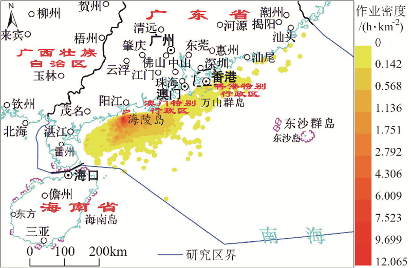
The Automatic Identification System (AIS) provides extensive vessel-tracking data for monitoring illegal fishing, forecasting central fishing grounds, quantifying fishing efforts, and protecting the marine environment. Existing research on AIS data has mainly focused on vessel movement patterns and spatiotemporal activity intensity; however, vessel type classification and activity analysis have rarely been associated with voyages. Focusing on the importance of voyages in vessel behavior analysis, this study proposed a voyage-based ship classification method wherein a multidimensional feature set was constructed to integrate the overall shape of the voyage, motion characteristics, and geographic background information, enabling a more accurate and interpretable classification and facilitating the pattern discovery of fishing vessel behaviors. Using soft voting based on probability averaging to integrate the XGBoost and LightGBM models, a better balance between accuracy and minority class recognition capability was achieved. Based on the distinction between fishing and non-fishing vessel voyages, the spatial and temporal characteristics of fishing vessel voyages on Hailing Island in Guangdong Province were systematically analyzed. The following results were obtained: 1) the accuracy of the voyage-based ship classification model reached 0.930. The model's decisions mainly rely on the ship size, sailing speed, trajectory shape, water depth, distance from the shore, and time preference. Among these, the contribution of ship size and speed to make the decision exceeded 63%, rendering them the most important features; meanwhile, spatial environment, trajectory patterns, and time-related behaviors played a supplementary role. 2) The number of fishing vessels and voyages showed evident monthly variations: the lowest numbers were observed during the South China Sea fishing moratorium, while the primary and secondary peaks occurred in the month before the moratorium began and in the first month after it ended. 3) The departure times of fishing vessels were relatively concentrated between T 03:00−05:59 and T 16:00−16:59, while return times were concentrated between T 13:00−15:59 and T 06:00−06:59; consequently, two short-duration operation patterns were established: early morning departure with same-day return in the afternoon, and evening departure with an early morning return the next day. 4) Voyages mainly involved nearshore fishing, and those lasting 6-12 hours and involving sailing distances of within 100 km accounted for more than 46.82% and 72.20% of the total number of voyages, respectively. 5) More than 75% of such voyages were local trips between Hailing Island and other parts of Yangjiang City, with only a small number travelling to neighboring cities; this indicated that the fishery network was highly localized. 6) The fishing operation areas were concentrated in the nearshore region south of Hailing Island, with water depths up to 40 m and a maximum operation density of 12.065 h/km2. From the core area outward, the operation density decreased rapidly with increasing distance. This study reveals that fishing vessels on Hailing Island are highly dependent on nearshore resources and significantly affected by fishing moratorium policies, suggesting that current fishery management policies have begun to show positive effects on resource protection; however, there exists a need to further promote structural adjustments in the fisheries industry and encourage the development of distant-water fishing and marine aquaculture to alleviate the pressure on nearshore resources.
Satellite-based single-photon measurements from ICESat-2 (Ice, Cloud, and Land Elevation Satellite-2) are used to extract bathymetry data as training samples or constraints. In conjunction with the extensive spatial coverage provided by multispectral imagery, facilitating the development of a fused active-passive optical remote sensing water depth inversion model. This integrated methodology has emerged as a mainstream solution for efficient and large-scale water-depth remote sensing, particularly in regions where traditional in situ data acquisition is challenging or impractical. Despite the promising capabilities of this approach, the accuracy of water depth inversion is predominantly constrained by the precision of extracting bottom single-photon signals. Conventional clustering algorithms employed for photon signal extraction often suffer from limitations, such as the generation of discontinuous underwater photon point clouds or production of point clouds with excessive thickness. Such deficiencies compromise the spatial continuity and boundary clarity of the reconstructed underwater topographic profiles, adversely affecting the subsequent water depth inversion accuracy. To address these challenges, this study introduces a novel methodology based on terrain profile fitting for shallow water depth optical remote sensing detection without in-situ data. The proposed method begins by acquiring bottom single-photon signals using an advanced clustering algorithm. Subsequently, local weighted regression and spline interpolation techniques were applied to the extracted photon-point cloud data. This dual-step process facilitates the reconstruction of underwater photon point clouds and effectively compensates for data gaps, yielding a continuous and coherent underwater topographic profile that represents bathymetric features more accurately. Following the enhancement of the underwater topographic data, water depth correction was performed. This correction accounted for various environmental and sensor-specific factors, ensuring that the derived depth values were both accurate and reliable. The corrected water depth data were then integrated into Sentinel-2 multispectral imagery, leveraging the extensive spectral and spatial coverage of the imagery to further refine the bathymetric inversion process. In this integration phase, we constructed a water depth inversion model based on band ratio analysis, which exploited the spectral reflectance properties of water to determine water depth with higher precision. The efficacy of the proposed method was rigorously evaluated using experimental datasets from Sentinel-2 and ICESat-2 collected over three distinct study regions: Molokai Island, Crooked Island, and Quanfu Island. Using the results of the widely employed DBSCAN clustering algorithm, comparative analyses was conducted. Experimental results demonstrate that, for Molokai Island, the proposed approach achieved a coefficient of determination (R2) of 0.98 and root mean squared error (RMSE) of 0.70 m, compared with that of the ICESat-2 bathymetry validation set. Regarding Crooked Island, the model validation accuracy was further enhanced, with R2 reaching 0.94 and RMSE decreasing from 0.28 to 0.22 m, representing a 21% improvement. Similar improvements in water depth inversion accuracy were noted for Quanfu Island. These findings substantiate the feasibility of the terrain profile fitting-based method. By enhancing the continuity and clarity of underwater photon-point cloud topographic profiles, the robustness of water-depth inversion models can be significantly improved. Accordingly, this study offers robust technical support for optical active-passive shallow water depth inversion, thereby facilitating more precise and extensive bathymetric mapping in coastal and shallow-water environments.

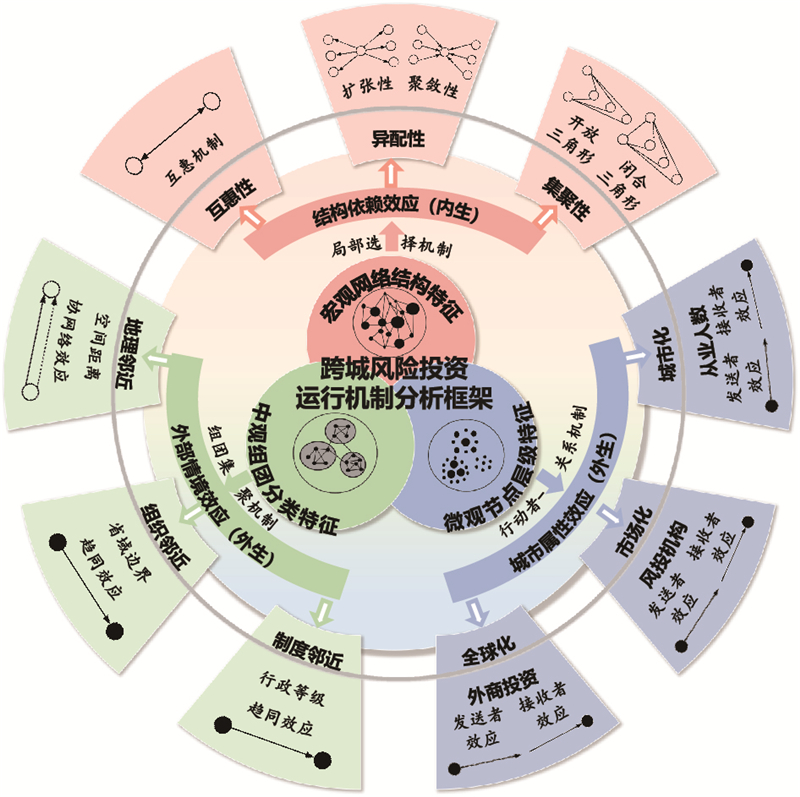
Cross-regional venture capital investments are crucial drivers for reshaping urban and regional economies, and their structural characteristics and operational mechanisms are popular topics in economic and urban geography. Based on intercity venture capital flows in the Yangtze River Economic Belt from 2006 to 2022, directed and weighted networks were constructed at six time points, and the network structural characteristics were analyzed from the perspectives of micro-node hierarchy, meso-cluster classification, and macro-topological attributes. Subsequently, the underlying operational mechanisms of intercity venture capital flows were further explored through the lenses of endogenous structural, urban attribute, and external contextual effects using exponential random graph models. The results showed that (1) Shanghai has consistently remained the core of venture capital networks in the Yangtze River Economic Belt, followed by Hangzhou, Nanjing, Wuhan, Chengdu, and Chongqing. Investment clusters are highly aligned with provincial or regional administrative boundaries, forming a strong cluster in the Yangtze River Delta, a dual-core cluster in Chengdu and Chongqing, a multicenter cluster in the middle reaches of the Yangtze River, and emerging clusters in Yunnan and Guizhou. (2) The core-periphery differentiation of intercity venture capital networks in the Yangtze River Economic Belt is prominent. The overall investment scale and intercity investment intensity of the networks increased, reciprocity and small-world characteristics were continuously strengthened, and network structures were gradually optimized. (3) The endogenous operational mechanisms of intercity venture capital flows in the Yangtze River Economic Belt evolved from reciprocal and preferential attachment mechanisms in the early stage to a later triadic closure mechanism driven by multiparty games. Regarding the exogenous operational mechanisms, the globalization, marketization and urbanization of cities promoted intercity venture capital flows, however, the roles of globalization and urbanization were decreasing whereas the role of marketization was increasing; the driving force of geographical and organizational proximity between cities to intercity venture capital flows was also decreasing. Based on these empirical findings, this study proposes policy recommendations for optimizing financial resource allocation and promoting coordinated regional development through network agglomeration and diffusion, urban functional division and interaction, and intercity barrier breaking and integration. Departing from existing research, this study systematically aligns network structural analysis with operational mechanisms across the micro-, meso-, and macro-levels, constructing an integrated multiscale analytical framework and a simulation methodology for complex networks. The applicability of this framework is validated through empirical investigation of intercity venture capital networks in the Yangtze River Economic Belt with the aim of deepening our understanding of intercity venture capital investment mechanisms while providing insights for research on other urban networks.
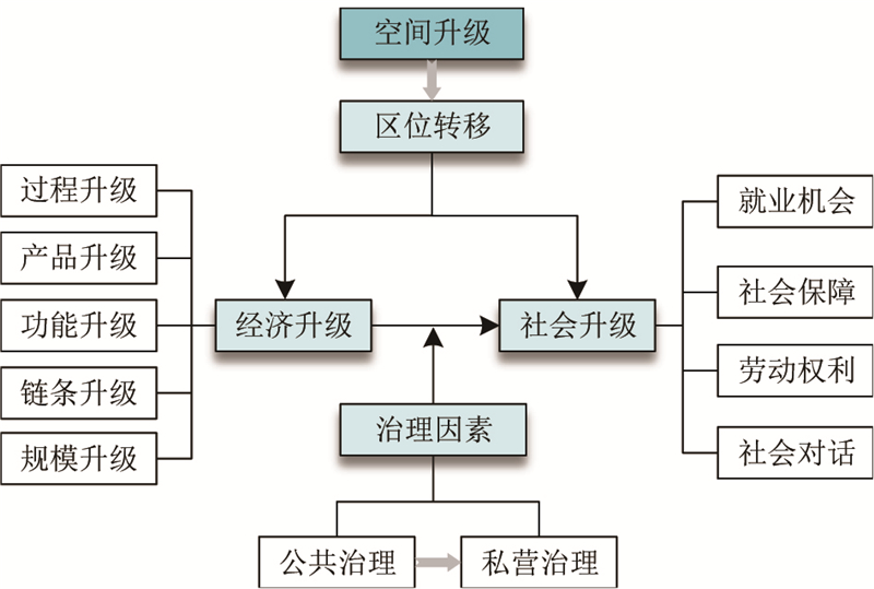
Against the backdrop of industrial relocation in China, enterprise migration is reshaping production organizations and labor structures, making the relationship between Economic Upgrading (EU) and Social Upgrading (SU) increasingly complex. Existing studies have paid limited attention to how the institutional changes triggered by regional relocation influence SU at the micro level. To address this gap, this study uses S Enterprise, a furniture manufacturing firm that relocated from Shenzhen to Anji in Zhejiang Province, as a case study. Based on in-depth interviews, participant observations, and internal enterprise materials, this study investigated the mechanisms through which the EU affected SU under regional relocation and examined the differentiated roles of public and private governance in this process. The findings showed that enterprises achieved multiple forms of EU during relocation, including process, product, functional, chain, and scale upgrades. However, the social consequences of these upgrading processes are characterized by the coexistence of social upgrading and downgrading. Automation, managerial optimization, and supply chain integration improve production efficiency and generate positive SU outcomes, including job creation, wage growth, expanded training opportunities, and broader career development channels. However, technological substitution reduces low-skilled positions, whereas product diversification and increasing orders intensify labor pressure and transform the original wage system, leading to a decrease in income among some experienced workers. Therefore, EU did not automatically translate into SU but instead involved an unequal distribution of upgrading benefits and costs. This study further demonstrated that regional relocation reshapes the institutional environment in which the enterprise is embedded, becoming a key condition for differentiated SU outcomes. In the destination region of Anji, relatively comprehensive public governance arrangements concerning wage standards, industrial support, talent recruitment, and living conditions provide institutional support for improving workers’ employment quality and living standards. For example, the enterprise maintained Shenzhen-level wage standards after relocation, enabling formal workers to earn wages above local market levels. However, such institutional benefits were unevenly distributed across labor groups. Temporary workers, largely controlled by third-party labor agencies, lack stable protection and promotion opportunities and become particularly vulnerable during industrial fluctuations, facing a higher risk of social downgrading. Compared to public governance, private governance primarily reflects adaptive responses to the new institutional environment rather than proactive social responsibility initiatives. Although the enterprise improved wages, performance bonuses, and dormitory conditions for some workers, efficiency-oriented strategies such as dual-track employment systems, extended working hours, and intensified performance management further widened the disparities between permanent and temporary migrant and local workers. Overall, the primary driving force behind SU during the early stage of relocation stemmed from institutional provisions within the public governance system, whereas corporate governance amplified the differentiated outcomes among labor groups. This study reveals the "asymmetry between the benefits and costs of upgrading" during the process through which EU influences SU, demonstrating that SU is not an automatic outcome of EU but is jointly shaped by spatial restructuring, institutional environments, and governance arrangements. By incorporating spatial restructuring and governance differentiation into EU and SU analysis, this study provides micro-level evidence for understanding labor transformation and industrial relocation in contemporary China.
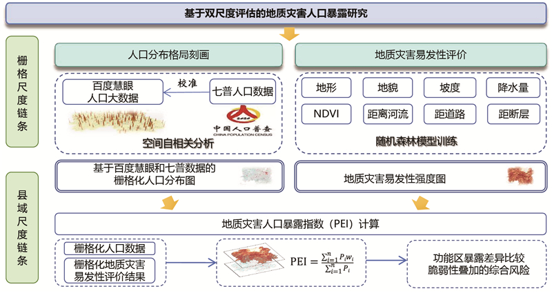
The accurate identification of population exposure to geological hazards is an important prerequisite for disaster risk prevention and territorial governance. In published studies in the literature, the main focus was on the assessment of susceptibility to geological hazards, whereas the spatial coupling of fine-scale population distribution, population vulnerability, and territorial planning has received relatively limited attention. Based on the theoretical perspective of human-environment relationships in territorial planning, a grid-county dual-scale assessment framework was constructed in this study to evaluate population exposure to geological hazards. Taking Hunan Province, China, as the study area, we first used Baidu Huiyan population big data calibrated with county-level data from the Seventh National Population Census to characterize the 1-km-gridded population distribution. Then, using the landform, slope, precipitation, NDVI, land use, distance to rivers, distance to roads, lithology, and distance to faults as factors, a random forest model was trained to assess the susceptibility to geological hazards. On this basis, a Population Exposure Index for geological hazards was constructed using a population-weighted spatial overlay, and county-level exposure patterns were further analyzed in relation to population vulnerability and territorial spatial planning units. The results showed that the population of Hunan Province is distributed in an “east-high, west-low, core-outward” pattern. Areas with a high population density are mainly concentrated in the Changsha-Zhuzhou-Xiangtan urban agglomeration and extend toward the Dongting Lake Plain and central Hunan Basin, whereas the western and southern mountainous areas are characterized by a relatively low population density. However, the population vulnerability is not fully consistent with the population density. Some mountainous and hilly areas have a relatively low population density but high social vulnerability, indicating that the social basis of disaster risk is spatially uneven. The results of the geological hazard susceptibility analysis showed a clear pattern of “high in mountainous and hilly areas and low in plains and urban areas.” Areas with high susceptibility are mainly distributed along the Wuling, Xuefeng, and Nanling mountain ranges, whereas those with relatively low susceptibility include the Dongting Lake Plain and Changsha-Zhuzhou-Xiangtan urban region. The county-level Population Exposure Index further revealed a spatial pattern different to that of population density alone. Overall, population exposure is higher in mountainous areas and lower in plains, suggesting that geological hazard exposure is not simply determined by population concentration but is the result of the spatial overlay between population distribution and geological hazard susceptibility. Although the Changsha-Zhuzhou-Xiangtan urban agglomeration and Dongting Lake Plain are densely populated, their exposure levels are relatively limited because of their lower susceptibility to geological hazards. By contrast, although parts of western and southern Hunan have smaller populations, settlements are often located in valleys, piedmont zones, and other local areas with higher susceptibility to hazards, resulting in higher population exposure. Additionally, the analysis of the main functional zones revealed differentiated exposure structures. National key ecological function zones showed the highest and relatively stable exposure levels, whereas provincial urbanization areas showed stronger internal variation despite also showing relatively high exposure levels. After controlling for natural background conditions such as elevation, slope, landform, and lithology, the main functional zone types still showed significant explanatory power for the Population Exposure Index, indicating that exposure differences across functional zones cannot be fully explained by natural conditions alone and may also be related to territorial development patterns and functional zoning arrangements. This study extends the assessment of geological hazard susceptibility from the identification of hazardous environments to the evaluation of population exposure and vulnerability-informed risk representation. It also links gridded exposure measurements with county-level territorial spatial governance units, thereby improving the applicability of exposure assessments to territorial spatial planning. These findings provide quantitative support for identifying priority governance units, improving geological hazard prevention, and promoting differentiated territorial spatial management.
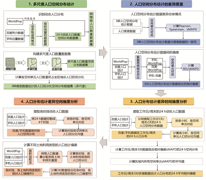
Accurate spatial population distribution data are indispensable for socioeconomic development, urban planning, and public policymaking. With the proliferation of diverse data sources, including statically modeled datasets and dynamic real-time feeds, a systematic and quantitative evaluation of their characteristics, biases, and optimal application scenarios is urgently required to inform reliable, data-driven decisions. This study aimed to address this gap by conducting a comprehensive spatiotemporal analysis of three representative data sources and comparing them with authoritative census data to elucidate their strengths, limitations, and complementary roles. This study employed Quanzhou City, a major coastal urban center in China, as a case study. We constructed two core metrics, Relative Difference and symmetric Mean Absolute Percentage Difference (sMAPD), to quantify the discrepancies. Three data sources were analyzed: static WorldPop data representing modeled long-term distribution; hourly dynamic Baidu Heatmap data reflecting location-based service demand; and mobile phone location data capturing passive device presence. These datasets were subjected to pairwise comparisons across multiple spatial and temporal scales and systematically compared with national population census data. This analysis yielded several key findings. First, regarding scale-dependent performance, all datasets showed high correlation with census data at the township level and above, confirming their utility in capturing broad spatial patterns. At the district scale, static WorldPop data demonstrated superior overall consistency, establishing its strength for macroscale assessments. At the township level, dynamic data showed slightly higher correlation coefficients than those of WorldPop; however, WorldPop and mobile data exhibited lower sMAPD values than those of Baidu data, highlighting a divergence between pattern similarity and numerical accuracy. Second, dynamic data exhibited systematic spatial differences, overestimating populations in central urban areas and underestimating populations in rural zones. sMAPD values were also temporally volatile, with intraday fluctuations reaching significant levels. Between the dynamic sources, Baidu Heatmap data displayed greater temporal volatility and spatial polarization than those of mobile location data. Third, data accuracy was strongly influenced by land use type. Relative Difference values were minimal in residential areas but significantly larger in commercial and public service zones. Fourth, the differences stem from distinct data generation logic: static data reflect institutional population frameworks, mobile data capture the presence of ambient activity, and Baidu data sense explicit demand intensity. This study concludes that no single data source is optimal. Static data are most suitable for macroscale and long-term strategic planning and resource allocation because of their stability. Dynamic data are essential for monitoring short-term population mobility and fine-grained spatial patterns. Specifically, mobile location data are preferable for understanding overall activity patterns and commuting behaviors, whereas Baidu Heatmap data excel in real-time sensing of demand-intensive areas for applications, such as commercial planning or emergency response. We propose a synergistic framework for practical applications using census data as the fundamental benchmark, static data to delineate the macropopulation structure, and dynamic data to monitor and analyze spatiotemporal changes. This study provides a replicable methodological framework for multisource population data evaluation and offers concrete, scenario-specific guidance for data selection, thereby enhancing the scientific basis for urban governance and planning.
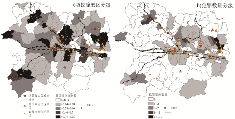
Tomb robbery poses a severe threat to cultural heritage preservation, necessitating precise prevention strategies adaptable to grassroots grid-based governance. This study examines the spatial differentiation characteristics and influencing factors of tomb robbery in City B. Using 150 crime records (2011-2019) from the China Heritage Crime Information Center, it aims to identify vulnerable localities for targeted control. The "township" served as the basic analytical unit, aligning with grassroots local administrative and policing units in China. At this scale, we integrated multi-source data including demographic/economic statistics, points of interest, and transportation networks. Methodologically, spatial patterns were first identified using kernel density estimation (KDE) and Standard Deviational Ellipse (SDE) analysis. Subsequently, to build a vulnerability assessment model, we tested several machine learning classifiers (Random Forest, XGBoost, CatBoost) predicting crime occurrence (binary: 0=no crime, 1=crime occurred) based on theoretically derived environmental, guardianship, and population indicators. XGBoost demonstrated superior performance (Accuracy ≈ 75.83%, AUC ≈ 80.02%) and informed the selection of eight key factors. Critically, we improved the traditional Vulnerable Localities Index (VLI) method by employing Shapley Additive exPlanations (SHAP) analysis on the trained XGBoost model to objectively derive data-driven weights (contributions) for these factors, replacing subjective expert scoring. The results highlight distinct spatial patterns and dynamics: (1) Tomb robbery crimes display a "broad coverage, local concentration" pattern. While 41.8% of the 122 townships recorded incidents, high-frequency townships (≥2 incidents) constituted nearly 20%, concentrated in relic-rich central/eastern regions. SDE analysis confirmed a strong spatial association between the overall crime distribution and the concentration of both national and provincial Key Protected Heritage Sites (KPSs), particularly aligning with provincial KPSs. (2) A multi-scale target selection strategy emerged: Macro-level KDE hotspots are spatially adjacent to dense clusters of KPSs. However, micro-level SHAP interpretation reveals criminals tend to bypass the well-protected core areas of these KPSs, shifting instead towards selecting more vulnerable, less-monitored targets situated in surrounding fields, reflecting rational risk-reward assessment. (3) SHAP quantified key factor impacts, identifying significant inhibitors and facilitators of crime: low population density, geographical remoteness (evidenced by negative contributions from total road length and railway presence), and low economic activity (negative from per capita industrial output) are associated with higher vulnerability, aligning with reduced guardianship. Water bodies significantly inhibit crime, likely by restricting accessibility. Conversely, farmland/forest influence was indistinct. Notably, the geographical distribution of public security authorities and cultural heritage administrations showed negligible impact on location selection at the township scale. Building upon these SHAP-derived weights, the study generated a township-level graded Prevention and Control Vulnerability Map, classified into five distinct levels using the Jenks natural breaks method. This map provides actionable intelligence directly serving grid-based governance. It offers scientific support for implementing tiered responses and dynamic adjustments based on vulnerability levels, facilitating differentiated resource allocation: prioritizing enhanced monitoring in high-vulnerability zones while maintaining standard protocols elsewhere. This data-driven framework aims to enhance the overall efficiency of regional cultural heritage protection, extending crime geography applications to rural heritage crime and offering empirical insights for optimizing policing and heritage management strategies.
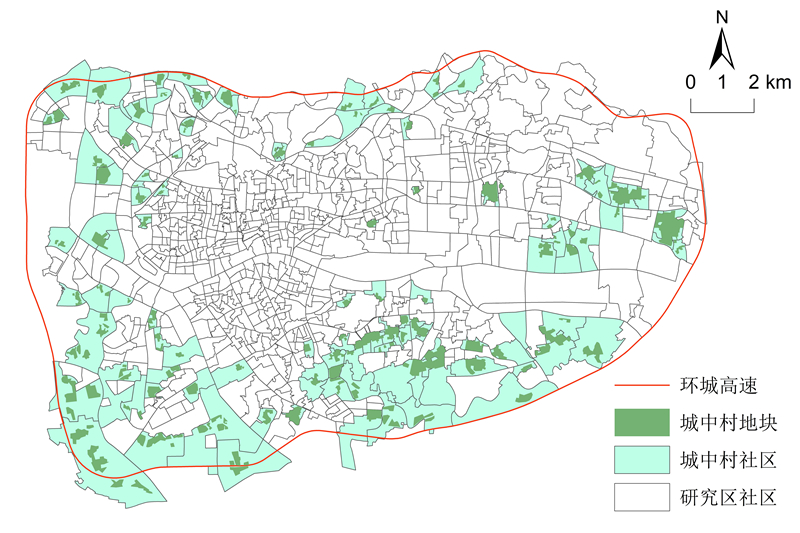
Crimes in villages in the city (ViCs) seriously affect social stability, with the unique residential segregation phenomenon serving as an important entry point for analyzing crime issues. However, the current research lacks systematic studies based on spatial statistics on the relationship between residential segregation and burglary in ViC communities. This study aimed to fill this gap. The study area consisted of 123 ViC communities within a ring expressway in ZG City, China. We extracted ViC plots using satellite imagery and estimated the ViC population using the building footprints and heights provided by Amap. Neighborhood and local segregation indexes were developed. These indices and the traditional segregation index were used to test the relationship between residential segregation and burglary. The covariates were selected with the guidance of social disorganization theory, rational choice theory, and crime pattern theory. The results of the negative binomial regression models show that, first, none of the traditional segregation index, neighborhood segregation index, or local segregation index has a significant impact on burglary, indicating that residential segregation in ViC communities is not a statistically significant factor in explaining burglary in ViC communities. This finding contradicts those of Western local-scale studies that show significant effects of residential segregation on crime. This contradiction may be due to the essential differences in the formation of residential segregation between China and the West, leading to markedly different effects on residents' daily activities. Western research has found that residential segregation tends to confine people’s activities to residential neighborhoods, thereby amplifying segregation effects. However, residential segregation in ViC communities does not affect residents' daily activities outside of their residences, and the high mobility of daily activities among ViC residents may weaken the effects of residential segregation. Meanwhile, the proportions of the elderly and population and the proportion of highly educated populations have significant negative effects on burglary because of their informal social control in communities. The number of catering and convenience stores, the number of bus stops, and the ViC area had significant positive effects on burglary, indicating that communities with more facilities acting as crime generators, better accessibility, and larger ViC areas were more susceptible to burglary. By introducing neighborhood effects to enrich segregation measurements, this study overcame the limitations of the traditional index that ignores spatial associations. However, none of the indices showed a significant association with burglary. This study provides empirical evidence for the lack of a relationship between residential segregation and burglary in the Chinese context at the community level. The findings also offer insights that may help improve policing practices and crime prevention in ViC communities, and contribute to enhancing the effectiveness of public security management in urban villages.
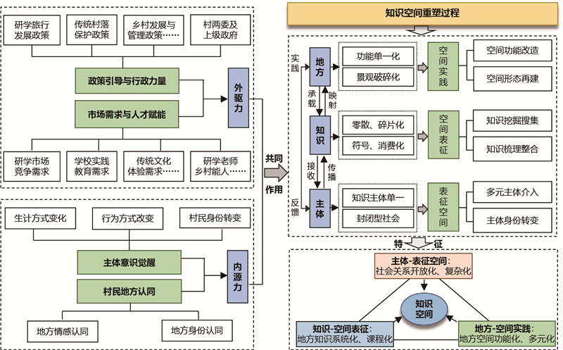
The ongoing march of urban-rural integration is placing traditional villages in an unprecedented predicament characterized by the erosion of locality. The preservation of local knowledge is increasingly being threatened by a discontinuity in inheritance and dissolution of values. Consequently, ensuring the continued transmission of local knowledge in traditional villages has recently become a focal issue of scholarly concern. To address this issue, in this study, we adopted the theory of spatial production as an analytical foundation and employed qualitative research methods, including participant observation and in-depth interviews, to construct a three-dimensional theoretical framework of knowledge space, encompassing "knowledge-place-subject". Taking Dayuan Village in Suining County, Hunan Province, as a case study, we examined the logical mechanisms underlying the evolution of knowledge space. The findings indicated that the evolution of knowledge space in Dayuan Village can be divided into three stages, namely, the initial, development, and rapid development stages. stages, The initial stage involves the adoption of a villager self-organization model, whereas the developmental stage is dominated by village committees with villager participation, and the rapid development stage is characterized by a multi-collaborative model involving enterprises, village committees, and villagers. Overall, the evolutionary process is characterized by a clear transition from a single-subject governance mode to multi-stakeholder collaborative governance. With respect to the evolutionary characteristics of knowledge space, from the perspective of spatial practice, cooperation between the village and enterprises has enabled the revitalization of idle and abandoned houses within the village and the reactivation of farmland water channels. This in turn has contributed to realizing the functional and diversified utilization of local space, transforming this from a single function of production and living to a combined function of "production, living, and education" In terms of spatial representation, local resources are being utilized to empower local knowledge, which involves transforming the scattered oral transmission of practical knowledge into a systematic and curriculum-based knowledge system. With respect to representational space, different entities, including the government, enterprises, villagers, and study tour groups, have contributed to the evolution of knowledge space, and social relations have shifted from traditional reticence to openness and diversity. In this context, the discourse game has made social relationships increasingly complex. With regard to the mechanisms underlying the evolution of knowledge space, external factors (policy, administration, market, and talent) and internal forces (awakening of subjective consciousness and villagers’ local identity) have been found to synergistically promote the development of knowledge space. In this context, policies and administration provide institutional guarantees and resource support, whereas the market and talent stimulate the internal vitality of the village through optimized resource allocation and value realization, thereby supplying dynamic support for the evolution of knowledge space, and transformation of villagers’ subjective agency promotes the reconstruction of spatial value. In addition, the interaction and mutual influence of internal and external factors have facilitated the dynamic evolution of the "knowledge-place-subject" dimension, jointly advancing the evolution of the knowledge space. From a micro-level perspective, we also examined the mechanism underlying the evolution of knowledge space in traditional villages within the context of tourism development. Specifically, with respect to study tourism, we sought to augment the existing body of research on traditional village space through a novel analytical lens and, within the framework of the rural revitalization strategy, provide new insights for industrial transformation and economic development in similar traditional villages, which we believe will have significant practical implications.
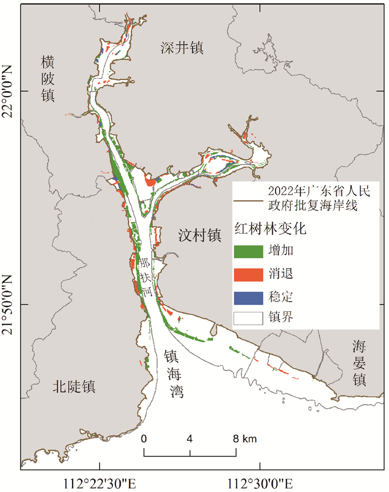
Clarifying the long-term evolutionary patterns and underlying driving mechanisms of mangrove landscape structures is a fundamental prerequisite for the scientific conservation and targeted restoration of coastal wetlands globally. In this study, in which we focused on the Zhenhai Bay mangrove ecosystem in Guangdong Province, a representative site within the rapidly urbanizing Pearl River Delta, we utilized a comprehensive long time-series of Landsat remote sensing imagery spanning the period from 1993 to 2025. By integrating robust analytical frameworks, including land-use transfer matrices, a suite of landscape pattern indices, such as Patch Density, Landscape Shape Index, and Cohesion, and centroid migration trajectory analysis, we systematically decoded the complex spatiotemporal dynamics of mangrove landscapes over more than three decades. Furthermore, we quantitatively identified the core driving factors and their shifting relative importance at distinct evolutionary stages. The results revealed that during the past 30 years, the Zhenhai Bay mangroves have transitioned through three distinct phases, namely, an initial “sharp decline,” followed by a gradual “recovery,” and subsequent “expansion,” which has been accompanied by a pronounced transformation in the dominant driving mechanisms. The period from 1993 to 1998 was characterized by a sharp decline, during which, there was a marked contraction in the area of mangrove vegetation at an annual rate of 9.6%. This shrinkage was primarily attributable to the direct encroachment and potential habitat blocking from expanding aquaculture pondst, leading to severe landscape fragmentation and a significant loss of ecological functions, such as carbon sequestration. From 1998 to 2014, the ecosystem entered a phase of gradual recovery. During this period, in response to the stringent implementation of targeted conservation policies and establishment of nature reserves, the human-induced degradation was effectively halted and subsequently reversed, primarily through natural regeneration and the accretion of sediment. This era marked a pivotal turning point, during which, passive protection enabled natural processes to slowly restore landscape connectivity, although the rates of expansion remained moderate. The most substantial changes occurred during the phase of rapid expansion from 2014 to 2025. Promoted by national strategies, including the “Blue Bay” restoration project, the total area of mangrove increased by an unprecedented 162.6%. Notably, this recovery coincided with a fundamental shift in the underlying mechanisms from a predominance of natural regeneration to a more synergistic process combining large-scale artificial restoration with accelerated natural expansion. Notably, artificially planted mangroves accounted for over 235 hectares of the restored coverage, representing 53% of the total increase. This massive afforestation effort, predominantly utilizing the exotic pioneer species Sonneratia apetala, augmented by natural colonization, promoted the development of landscape patterns characterized by a higher degree of aggregation and substantially enhanced connectivity, effectively reversing the patten of degradation observed during the 1990s. Our findings in this study reveal how restoration of the Zhenhai Bay mangroves has transitioned from passive damage control to a new era of high-quality, institutionalized ecological restoration. However, despite the impressive achievements, this rapid human-assisted expansion also raises concerns regarding potential long-term ecological risks associated with large-the scale introduction of exotic species. Although planting Sonneratia apetala represent an effective approach for accelerating land reclamation, the competitive dominance of this plant may threaten native biodiversity and potentially alter soil biogeochemical cycles. Future management should accordingly take into consideration the need to balance the desire to meet rapid greening goals with biodiversity conservation. In summary, this study has enabled us to identify key evolutionary processes and multi-stage driving mechanisms underlying the changing pattens in mangrove landscapes in response to intense anthropogenic pressure. These findings provide targeted theoretical foundations and actionable decision-making support for scientific conservation, precision restoration, and enhanced coastal ecological resilience. These insights are vital not only for Zhenhai Bay but also for the broader Guangdong-Hong Kong-Macao Greater Bay Area. Accordingly, this investigation represents a valuable and replicable case study for global mangrove management strategies aimed at mitigating the adverse impacts of climate change under the background of urbanization.
Cross-border transportation integration is a critical foundation for implementing the Guangdong-Hong Kong-Macao Greater Bay Area (GBA) strategy and promoting regional functional integration. To address limitations in existing research—particularly the insufficient characterization of cross-border vehicle flows and the limited interpretability of complex driving mechanisms—this study utilizes a comprehensive dataset comprising 623,133 valid origin-destination (O-D) records of Hong Kong- and Macao-licensed vehicles obtained from Guangdong’s expressway toll system in September 2023. By integrating network analysis, kriging interpolation, and an Optuna-optimized XGBoost model combined with SHAP (Shapley Additive Explanations), this study systematically explores the spatial flow patterns and multidimensional driving mechanisms underlying these vehicle movements. The results indicate the following: (1) The spatial distribution of Hong Kong and Macao vehicles exhibits a pronounced “core-periphery” structure characterized by strong polarization. The Pearl River Delta (PRD) functions as a high-intensity agglomeration core, whereas Eastern, Western, and Northern Guangdong constitute peripheral zones. Cities such as Shenzhen, Dongguan, and Zhuhai have emerged as key hubs with the highest betweenness centrality, effectively linking the PRD with non-core regions. (2) SHAP dependency analysis reveals significant nonlinear threshold effects and spatial heterogeneity among the driving factors. Spatiotemporal distance functions as a universal inhibitory factor, with a critical threshold occurring at approximately 130 minutes (or 110 km). Within this threshold, flow intensity declines sharply as distance increases; however, beyond this point, the marginal inhibitory effect of distance gradually weakens, producing a “long-tail” effect for medium-to-long-distance travel. Furthermore, the number of residents with Hong Kong, Macao, or overseas backgrounds five years earlier represents the primary promoting factor across the province, exhibiting a distinct "spatial gate effect," whereby positive influence increases exponentially only after surpassing a certain concentration threshold. Regionally, flows within the PRD are predominantly driven by industrial clusters, those in Western Guangdong are primarily influenced by scenic tourism resources, whereas Northern and Eastern Guangdong are more strongly shaped by per capita GDP and ancestral social networks. (3) Interaction analysis reveals differentiated coupling pathways: the PRD relies on the synergistic effects of industrial and economic drivers, whereas non-PRD regions are primarily influenced by the combined effects of tourism resources and commercial facilities. This study contributes an interpretable machine-learning framework that effectively decodes the "black box" of complex spatial interactions underlying cross-border mobility flows. From a practical perspective, the identification of a 130 minutes non-linear threshold provides a quantitative basis for optimizing transportation planning within the GBA. Accordingly, the implementation of "cross-border business commuter lanes" within the 130 minutes core zone and the enhancement of "ancestral tourism corridors" in peripheral regions are recommended to mitigate distance-related friction and support the GBA’s transition from “physical connectivity” to “functional integration.”
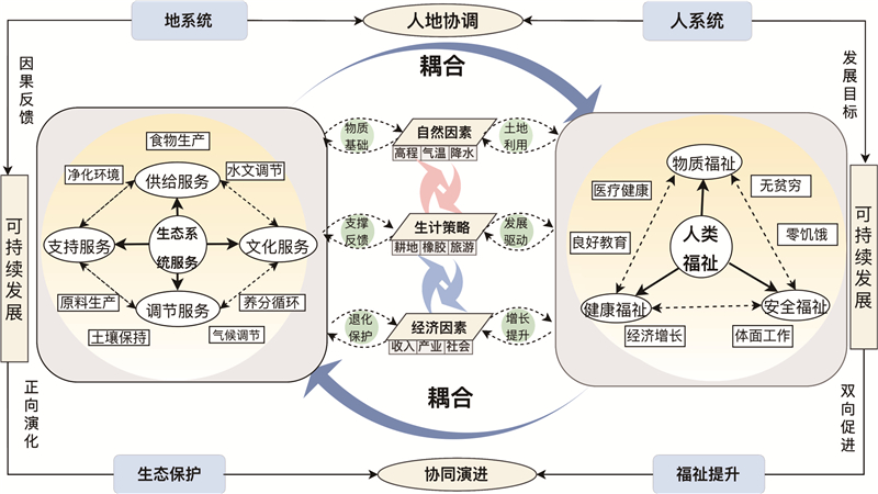
During the transition from prioritizing growth speed to emphasizing development quality, the tension between declining ecosystem services and growing demand for human well-being has become increasingly acute. Identifying pathways to enhance human well-being within ecological carrying capacity represents a key frontier in human-land systems research. Xishuangbanna, a vital tropical ecological barrier in China and gateway to Southeast Asia, has undergone a marked transition from traditional farming and rubber cultivation to ecotourism. This transformation makes it an insightful region for examining the dynamic interplay within human-land systems. However, intertwined pressures, such as border location, ethnic diversity, and geopolitical context, expose the area to the risk of ecological degradation and well-being disparities, potentially hindering the coupling mechanism between ecology and well-being. Consequently, there is an urgent need to explore pathways for synergistic development between ecology and well-being under livelihood transition; disentangle intrinsic linkages among livelihood, ecology, and well-being; and provide a theoretical reference for achieving sustainable livelihoods and coordinated ecology-well-being development in border regions, ultimately supporting the core objectives of strengthening regional ecological security and advancing human well-being. This study uses Xishuangbanna, a border area adjoining China, Laos, and Myanmar, as a representative case. The study applied ecosystem service value assessment, a human well-being evaluation system, and a coupling coordination degree model to analyze the spatiotemporal evolution characteristics of ES and HWB and their coupling coordination relation from 2000 to 2023. Furthermore, key factors influencing the ES-HWB coupling system were identified. The main findings are as follows: (1) From 2000 to 2023, the total value of ES generally exhibited a fluctuating trend. Spatially, areas with concentrated populations and large areas of cultivated and construction land generally have low ES values. By contrast, the composite HWB score shows an overall upward trend, especially from 2010 to 2015, with a notably rapid growth rate. At the county scale, clear disparities in HWB levels were observed, with Jinghong City scoring the highest. (2) From 2000 to 2023, the degree of coupling coordination between ES and HWB in Xishuangbanna improved, indicating an overall trend toward coordinated development. In 2023, Jinghong City and Mengla County achieved relatively high levels of coupling coordination, whereas Menghai County remained in the adjustment phase. (3) The coupled ES-HWB system is jointly driven by natural factors, livelihood strategies, and economic development. Natural factors, such as elevation, temperature, and precipitation, exerted relatively limited influence on the degree of coordination. Livelihood and economic factors emerged as the most critical drivers of changes in the coordination level. Moreover, interactions among different factors produced varied effects on the degree of coupling coordination, demonstrating nonlinear enhancement characteristics.
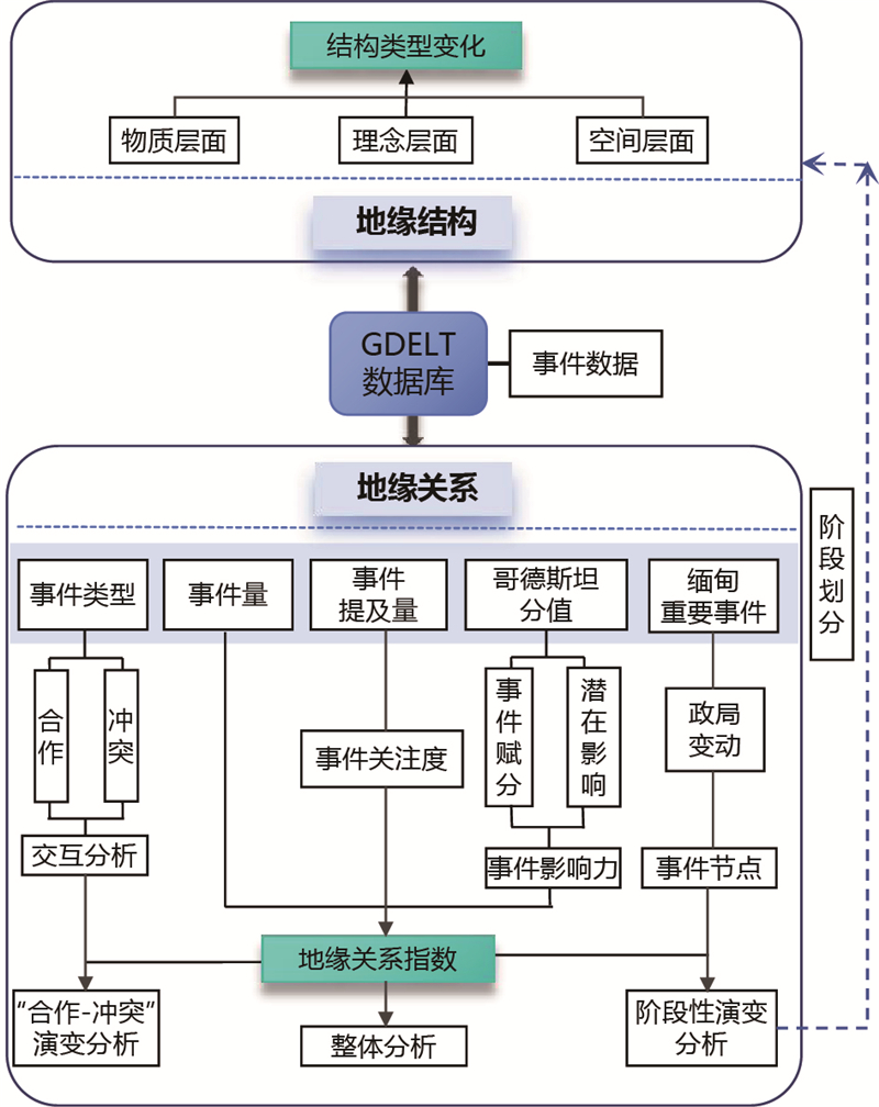
Amid intensifying great-power competition, Myanmar is situated in a "shattered zone" and has experienced profound transformations in its geopolitical relations and spatial structure. Clarifying the evolution of its geopolitical relationships and structures with major world powers is of great significance for understanding both the dynamics of Myanmar’s internal situation and the broader regional geopolitical landscape. This study aims to systematically examine the changes in geopolitical interactions, structural characteristics, and underlying mechanisms between Myanmar and major powers from 2013 to 2024. Methodologically, this paper draws on the GDELT event database to construct a multi-level analytical framework of "event-relationship-structure-mechanism." First, international events are identified and classified; second, geopolitical relationships are measured and divided into stages; third, the evolution of geopolitical relationships and structures is analyzed; and finally, a framework of "supporting forces-driving forces-friction forces" is introduced to explain the internal mechanisms shaping these changes. The results show that: 1) Myanmar’s geopolitical relation index exhibits an overall downward trend over the study period. After peaking in 2013, the index gradually declined, with a short-lived "V-shaped" rebound around 2016. However, the 2021 military coup represents a critical turning point, triggering a sharp collapse of the index. Since then, Myanmar’s external relations have displayed a pronounced divergence characterized as "cold in the West, hot in the East"; 2) In terms of geopolitical structure, Myanmar has gradually shifted from an early pattern of “multilateral connectivity” to one of "eastward dependence," characterized by reduced diversification of diplomatic ties and a significantly increased asymmetric dependence on Eastern countries.; 3) The evolution of Myanmar’s geopolitical relationships and structures is the result of the combined effects of multiple forces: on the one hand, supporting forces mainly consist of external support, on the other hand, driving forces propelled by external diversity, diplomatic autonomy, and developmental anxiety, while frictional forces emerge from the interaction between domestic political instability and external international pressure. The interplay between these forces jointly determines Myanmar’s geopolitical transformational trajectory. This study makes two major contributions to the literature. First, it introduces event data analysis into geopolitical research, constructing an integrated analytical pathway that links "events, relations, and structure," thereby enriching the field's methodological approaches. Second, the proposed multi-dimensional framework demonstrates broader applicability and can serve as a reference for analyzing other shatterbelt regions or small states under great-power competition. Overall, the study suggests that under intensifying great-power competition, Myanmar faces increasing structural constraints and external dependence. The case of Myanmar provides highly valuable insights for China. In its engagement with Myanmar, China should maintain stable interactions and respond flexibly to border security issues arising from internal changes in Myanmar. For small states in a complex, multipolar international system, foreign strategies should focus on enhancing structural autonomy, reducing the risks of single dependence through diversified diplomatic arrangements, and strengthening strategic choice capacity amid great-power competition.