With the accelerated transition of the global energy structure and expansion of the renewable energy sector, critical materials such as rare earth elements are becoming increasingly important in the wind power industry chain. However, the current complex geopolitical environment, constrains the free flow of the global wind power supply chain. Therefore, the trade network structure and evolutionary characteristics of critical products must be analyzed from a segmented industry chain perspective. Simultaneously, the Belt and Road Initiative (BRI) provides a multinational cooperation framework to systematically assess its role in promoting the integration of participating countries into the wind power industry chain trade network, enhancing their trade network positions, and alleviating resource and technology constraints. This study constructed a segmented global trade network for the wind power industry chain and quantitatively examined how BRI affects the trade network positions of participating countries, along with the underlying mechanisms. The study draws on trade data from 52 major countries and regions for the 2009-2022 period. Rare earth ores, rare earth permanent magnets, and direct-drive wind turbines were selected to represent the upstream, midstream, and downstream segments of the industry chain, respectively. A directed and weighted trade network was constructed to capture the structural characteristics and evolutionary trends of the network. A multi-period difference-in-differences model was employed to evaluate the impact of the BRI on the trade network positions of countries along the initiative’s route, and mechanisms such as policy coordination, infrastructure connectivity, and trade facilitation were incorporated to assess the channels through which the initiative affects trade network embedding. First, the results indicate that the global wind power industry chain trade network has become increasingly complex, with a growing scale, enhanced connectivity, and significant small-world properties across all segments, reflecting the networked nature of the global supply chain. Among the segments, the midstream permanent magnet network exhibited the highest connectivity and clustering, the upstream rare earth network was sparse, and the downstream complete turbine network was constrained by market access limitations and standardization levels. Second, Germany, the United States, and China are core countries across different segments, whereas the networks of major participating countries are becoming increasingly diversified, with resource-rich European countries such as Denmark and Belgium gaining greater importance over time. China’s position exhibits a composite pattern of "strong downstream, stable midstream, weak upstream," and through systematic cooperation under the BRI, its network position has improved. Despite certain bottlenecks in key technological control, China has become a key component in the global wind power industry chain, significantly influencing the production and application of wind power equipment. Finally, BRI significantly enhanced the trade network positions of participating countries in the wind power industry chain. The initiative’s effects exhibited pronounced heterogeneity across industry chain segments, levels of national development, and spatial corridors, with particularly strong effects observed for resource- and technology-intensive segments, developed countries, and countries along the Silk Road. The mechanism analysis indicates that policy coordination enhances network embedding through intergovernmental cooperation and foreign aid, whereas infrastructure and trade facilitation improve shipping connectivity and reduce tariffs, thereby indirectly enhancing the trade position of the countries. The contributions of this study are twofold. First, it constructs a global wind power trade network from a segmented industry chain perspective, revealing heterogeneous characteristics across segments. Second, it systematically evaluates the effects of the BRI on the policy, infrastructure, and trade dimensions, providing theoretical and practical guidance for formulating international renewable energy cooperation policies and optimizing the industry chain layout for participating countries.
Amidst the global transition toward renewable energy, China has emerged as the world leader in solar photovoltaic (PV) capacity and generation. However, the climatic risks and operational stability of this extensively deployed PV infrastructure under future climate change remain insufficiently assessed. Previous studies have primarily focused on the theoretical PV power-generation potential (PsolarPV) across terrestrial areas, overlooking the specific climatic risks of existing operational PV facilities. This study addresses this critical gap through a comprehensive, multi-dimensional risk assessment for China's deployed PV systems. We developed a high-resolution hourly PsolarPV model driven by a multi-model ensemble from the NASA Earth Exchange Global Daily Downscaled Projections (NEX-GDDP-CMIP6) under three greenhouse gas (GHG) emission scenarios from 2015 to 2060. Focusing on China’s existing deployed PV infrastructure and seven representative regions, we quantified future changes in annual PsolarPV and their driving factors, the frequency of extreme PV power events (energy "surplus" and energy “deficit” days), and intra-annual variability (short-term fluctuations and seasonal variations). Our results reveal that future trends in PsolarPV across China’s PV deployments are shaped by the opposing effects of increasing solar radiation (positive effect) and rising surface temperatures (negative effect). Under the low-emission scenario (SSP1-2.6), enhanced solar radiation dominates, leading to a nationwide increase in annual PsolarPV of 3.4%±0.4% (multi-model mean ± standard error). In contrast, under the high-emission scenario (SSP5-8.5), thermal-induced efficiency losses offset these gains, resulting in a slight increase of 0.6%±0.4% in PsolarPV and a rise in the frequency of poor-power days by 0.1 d per decade. Moreover, climate-induced impacts exhibited pronounced spatial heterogeneity. With increasing GHG emissions, deployed PV systems in northwestern, northern, and eastern China are projected to be the most climate-sensitive, experiencing greater changes in power-generation potential and more frequent extreme power-generation events. Northwest China, where PV deployments are concentrated, is projected to experience a decline of -0.5%±0.2% in PsolarPV and an increase of 1.0 d per decade in extreme poor-power days under the high-emission scenario. Conversely, the deployed PV systems in South and Southwest China exhibited stronger climate resilience. Furthermore, higher GHG-emission scenarios are expected to intensify seasonal and short-term PsolarPV fluctuations, especially in northern regions (e.g., Northeast, North, and Northwest China), posing greater challenges to grid stability and power dispatch management. In conclusion, this study provides the first location-specific, forward-looking climate risk assessment of China's existing PV infrastructure. These findings highlight that stringent GHG mitigation is critical for safeguarding solar energy assets and ensuring the long-term sustainability of PV power generation. They also emphasize the need for spatially differentiated climate adaptation strategies, including optimizing future deployment in climate-resilient regions, strengthening grid capacity with advanced energy storage, and enacting policies that enhance the climate resilience of China’s solar power system.
Driven by the “double carbon” goal, photovoltaic power generation has become a key pathway for the low-carbon transformation of energy. Focusing on Guangdong Province, a major energy-consuming region, this study constructs a multi-system coordinated evaluation framework and index system that integrate “resource endowment-development demand-bearing constraints” to evaluate the suitability and emission reduction benefits of photovoltaic land. Spatial clustering analysis of power demand and development potential was innovatively introduced to address the mismatch between supply and demand in photovoltaic development and to provide a scientific basis for the optimal layout of regional photovoltaic land. The results show that (1) the potential for photovoltaic land development in Guangdong Province is substantial, and the highly suitable photovoltaic area is 13,292 km2 (accounting for 7.3 % of the total land area). When the highly suitable area is fully developed (Q4 development scenario), the annual photovoltaic power generation in Guangdong Province reaches 960.5 billion kWh, which can meet the electricity demand of the entire province. (2) The spatial differentiation of photovoltaic land development potential in Guangdong Province is significant. The highly suitable and suitable areas account for 38% of the assessed area and are mainly distributed in the hills of eastern Guangdong and the Leizhou Peninsula. The low-suitability areas (generally suitable, less suitable, and unsuitable areas) account for 62% of the assessment area and are mainly distributed in the mountainous areas of northern Guangdong and the core area of the Pearl River Delta. Photovoltaic development in northern Guangdong is limited by undulating terrain, while available space in the Pearl River Delta is insufficient due to dense construction land. (3) Clustering results of suitable photovoltaic areas and electricity demand indicate that the mismatch between supply and demand of photovoltaic power generation in Guangdong Province is significant. The clustering results identify a conflict pattern of "supply less than demand" in the Pearl River Delta and "supply greater than demand" in eastern Guangdong. Huizhou City, as a high-high agglomeration area, demonstrates both local consumption capacity and radiation capacity toward the Pearl River Delta, indicating high priority for development. (4) The potential emission reduction benefits of photovoltaic power generation in Guangdong Province are significant. The development of all highly suitable areas could save 293 million tons of standard coal per year and reduce 781 million tons of CO2 emissions, corresponding to an emission reduction value of 53.29 billion yuan. At the same time, emissions of SO2, NOₓ, and TSP could be reduced by 6.46 million tons, 2.94 million tons, and 4.99 million tons, respectively. Vegetation under photovoltaic panels provides an additional carbon sink of 27,900 tons, contributing non-negligible emission reduction and ecological benefits. This study provides a decision-making paradigm of "potential assessment-spatial optimization-benefit quantification" for the precise allocation of provincial photovoltaic land. It proposes establishing differentiated land-use rules strictly linked to development potential levels, incorporating spatial synergy elements into the photovoltaic land planning system, and ultimately achieving a win-win outcome between energy transformation and land space optimization.
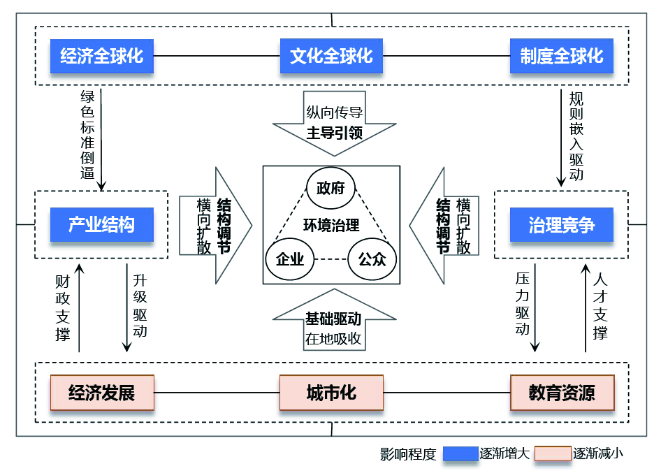
In the context of ecological civilization construction and high-quality development, exploring the mechanisms of local environmental governance transformation under globalization is of substantial academic significance for understanding regional sustainable development. Existing studies on environmental governance in the Pearl River Delta (PRD) have mainly examined the driving forces from a single perspective, such as economic development, industrial structure, and globalization. However, relatively limited attention has been paid to identifying the hierarchical roles and evolutionary dynamics of multiple factors from a multi-scalar interaction perspective, particularly the intermediary roles of institutional spillovers from Hong Kong and Macao in regional governance. To address this gap, this study develops an analytical framework of "globalization input-local response-environmental governance" from the perspective of the geography of sustainability transitions. Using the GeoDetector method, this study systematically examined the spatiotemporal evolution of environmental regulation intensity and its driving mechanisms across nine cities in the PRD from 1990 to 2018. The main findings are as follows. First, environmental regulation intensity in the PRD has increased continuously over time, exhibiting distinct stage-based transitions and forming a spatial gradient centered on highly open cities such as Shenzhen and Guangzhou. Second, the driving forces of local environmental governance evolved from an endogenous, development-driven stage dominated by economic growth and urbanization to a multi-scalar governance mode characterized by interactions between globalization inputs and local institutional responses. Lastly, institutional opening channels play a critical bridging role in governance transition. In particular, the number of first-class ports demonstrates the strongest explanatory power, indicating that global environmental rules and governance concepts are primarily embedded in local governance systems through institutional channels of opening. Under the influence of Hong Kong’s and Macao’s institutional spillovers, these processes further promote local institutional innovation and improve governance capacity. This study suggests that, in highly open regions, environmental governance transformation is driven jointly by global rule diffusion, local institutional absorption, and cross-jurisdictional institutional interactions. By revealing the evolutionary mechanisms of environmental governance from a multi-scalar interaction perspective, this study extends the explanatory power of the geography of sustainability transitions in the context of cross-border institutional interactions and regional institutional diversity. It provides new theoretical insights and empirical evidence for understanding environmental governance transformation in open regions.
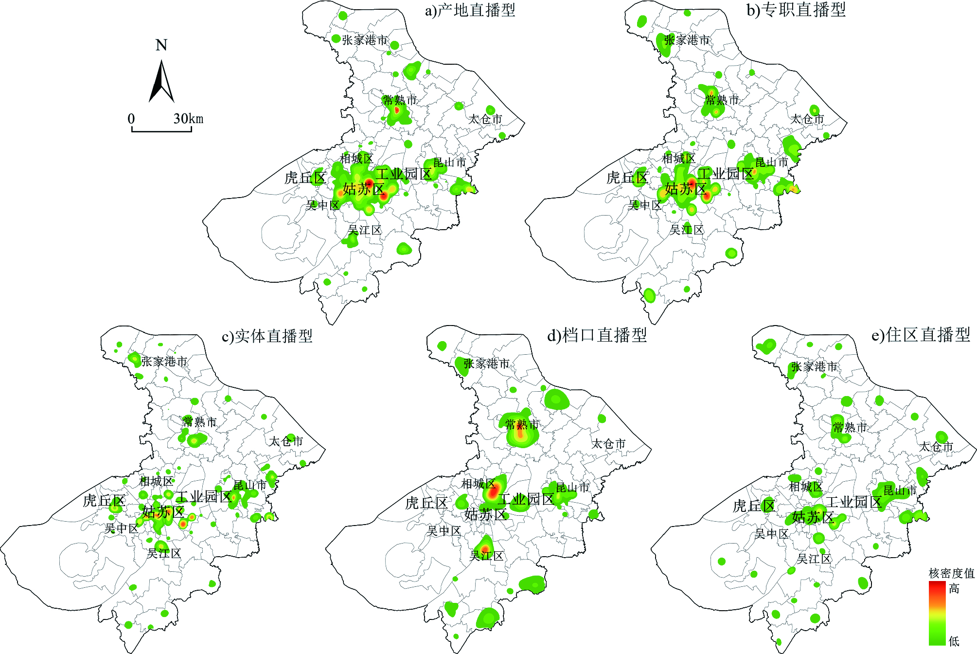
With the rapid advancement of the internet and digital communication technologies, particularly the widespread adoption of mobile internet and short-video platforms, e-commerce has undergone a new wave of transformation, giving rise to live-streaming e-commerce. As an emerging business model that integrates platform-based live streaming with online retailing, live-streaming e-commerce has, through its distinctive interactivity and immediacy, profoundly reshaped consumer purchasing behavior in China and has become a major driver of the urban digital economy. Against this backdrop, the spatial distribution of live-streaming e-commerce has become an increasingly important topic in geography, particularly in economic geography. However, existing research largely relies on single theoretical perspectives and seldom integrates the analytical logic of path dependence and path creation. In particular, a systematic theoretical explanation and empirical evidence remain lacking regarding how live-streaming e-commerce in cities anchored in the real economy develops distinctive locational patterns through interaction with pre-existing industrial structures. To address this gap, this study draws on the economic-geographical perspectives of path dependence and path creation and considers Suzhou, where the real economy and live-streaming e-commerce are closely intertwined, as a case study. Based on the spatial coordinate data on anchors engaged in live-streaming e-commerce, this study investigates the locational patterns and differentiated determinants of different types of live-streaming e-commerce on the urban scale. The results show that, first, live-streaming e-commerce in Suzhou exhibits a spatial pattern characterized by a high concentration in the urban core and multiple clusters in suburban areas. It also reveals a distinctive dual orientation towards both production bases and industrial service functions, indicating that the development of live-streaming e-commerce in Suzhou is a composite outcome of strong path dependence rooted in traditional manufacturing and path creation enabled by digital technologies and policy intervention. Second, significant heterogeneity exists in the locational patterns of different types of live-streaming e-commerce: production-based live streaming exhibits a“clusters plus dispersed points”pattern; professional live streaming exhibits a“pole plus multiple zones”pattern; brick-and-mortar live streaming an“axis plus dispersion”pattern; stall-based live streaming exhibits a“core plus nodes”pattern; and residential live streaming exhibits a“multiple zones plus dispersion”pattern. Third, the determinants showed both hierarchical and type-specific differentiation. Overall, manufacturing base, institutional policy, industrial foundation, and logistics conditions are the principal factors shaping the locational distribution of live-streaming e-commerce. By type, production-based live streaming is mainly influenced by manufacturing base and logistics; professional live streaming by institutional policy and producer services; brick-and-mortar live streaming by transport and logistics; stall-based live streaming by wholesale markets and logistics; and residential live streaming by producer services, transport, and the cultural environment. This study shows that the digital economy does not disrupted the locational logic of traditional industries; rather, it evolves through deep interaction with and restructuring of local industries, institutions, markets, and socio-spatial environments. Therefore, the locational distribution of live-streaming e-commerce results from the joint operation of path dependence and path creation. These findings enrich the theoretical implications of economic geography in the digital era, and offer a new perspective for understanding the synergistic relationship between inherited local development trajectories and emerging innovation paths in urban digital economic development.
In the context of rural revitalization, rural tourism has emerged as a pivotal driver of regional development. However, the spatial differentiation patterns and synergistic mechanisms underpinning characteristic rural tourism in the Yangtze River Delta Urban Agglomeration (YRDUA) remain inadequately characterized. To address this gap, we analyzed 1,526 national-level characteristic villages across 213 counties in the YRDUA, leveraging comprehensive datasets encompassing environmental, socioeconomic, and tourism-specific variables. Our methodological framework integrates kernel density estimation, the XGBoost-SHAP machine learning model, and location entropy analysis. Three principal findings emerge: (1) Characteristic villages exhibit a pronounced“denser in the east, sparser in the west” spatial distribution, with resource-type-driven agglomeration. Cultural villages, including traditional villages and historical-culturally famous villages, are concentrated along the Anhui-Zhejiang border, where a deep-rooted cultural heritage prevails. Ecological villages clustered in the mountainous areas of western Zhejiang and southern Anhui underscore the decisive role of natural endowments. Tourism-oriented villages, such as national key rural tourism villages, are predominantly situated near core urban centers (e.g., Shanghai), reflecting market accessibility as a primary locational determinant. (2) The XGBoost-SHAP model identified elevation, slope, population density, road density, and the number of A-level scenic spots as the five most influential predictors. Crucially, it uncovered significant nonlinear effects and strong interaction effects among these variables, demonstrating that tourism development potential arises not from isolated factors but from the interplay between biophysical constraints and socioeconomic enablers. (3) By integrating the assessments of development potential and location matching degree, we propose a four-zone functional classification for the YRDUA: the Characteristic Development Zone (7.5%), Collaborative Optimization Zone (10.8%), Quality-Efficiency Enhancement Zone (46.5%), and Potential Exploration Zone (35.2%). Each zone is assigned a targeted, evidence-based optimization strategy aligned with its structural attributes and developmental stages. For instance, the Characteristic Development Zone, located proximate to high-demand urban cores, should prioritize short-haul leisure offerings and cross-regional thematic tourism corridors, while the Potential Exploration Zone, endowed with abundant natural resources yet constrained by underdeveloped infrastructure and public services, requires strategic investment to activate latent assets and upgrade foundational service capacity. This study advances the methodological rigor by introducing XGBoost-SHAP to capture complex nonlinearities and interactions, which are limitations inherent to conventional regression- or rule-based approaches, thereby generating generalizable, statistically grounded insights beyond case-specific inference. It further contributes to a unified, empirically calibrated synergy framework for heterogeneous characteristic villages and delivers a spatially explicit, policy-actionable zoning scheme. However, this study had several limitations that warrant further investigation. First, data availability confines our scope to national-level designated villages, omitting local-level inventories and institutional dimensions, including designation categories and policy funding mechanisms, which may shape village trajectories, and therefore affect assessment comprehensiveness. Second, the natural break classification method introduces some subjectivity in threshold selection; therefore, practitioners should apply the zoning results flexibly, informed by local contextual knowledge. Future research should integrate multi-tiered village registries, incorporate institutional variables, and benchmark alternative machine learning models and spatial partitioning techniques to strengthen the robustness and transferability of the findings.
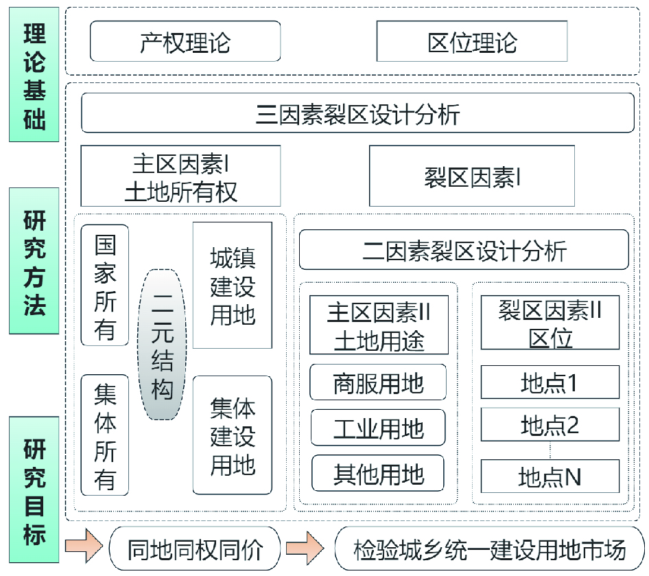
To test whether the collective construction land market and the state-owned construction land market in Nanhai District of Foshan City, the leading demonstration area of rural collective operational construction land, are integrated at different stages, this study collected a total of
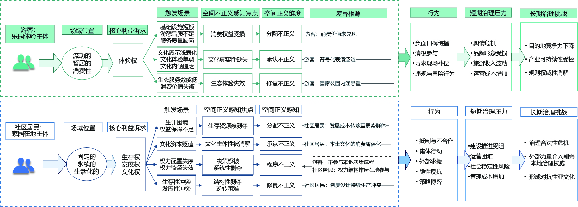
This study proposed a theoretical framework of "spatial justice perception-psychological transformation-behavior formation." Using multisource data, including semi-structured interviews, participatory observations, and secondary materials, the research applied a constructing grounded theory approach involving a four-level coding analysis: initial coding, focused coding, axial coding, and theoretical coding. By deconstructing individuals’ perceptions of spatial injustice, this study reconstructed the dimensions of spatial justice and examined the differences in perceptions and behavioral mechanisms between tourists and local residents. The key findings are as follows: (1) Both tourists and residents derive their spatial justice perceptions from issues of spatial injustice, which are reconstructed in four core dimensions: distributive justice, procedural justice, recognition justice, and restorative justice. For tourists, the psychological transformation mechanism operates as follows: perceptions of distributive, recognition, and restorative injustice trigger disappointment in service value, alienation in the cultural experience, and a sense of lack of ecological education, leading to imbalanced spatial value perception. Perceptions of distributive and recognition injustice shape cognitive biases such as deviation from group preferences and a lack of cultural respect, resulting in conflicts with spatial discipline. Perceptions of distributive and restorative injustice weaken behavioral confidence and decision-making autonomy, causing diminished spatial agency. For residents, perceptions of distributive, recognition, and restorative injustice induce survival anxiety, cultural anxiety, increased economic burden, reinforced doubts about fairness, and a heightened sense of deprivation, leading to perceived spatial survival pressure. Perceptions of procedural injustice foster intergroup opposition, intensify value conflicts, and erode group trust, resulting in a torn spatial identity. Perceptions of procedural and restorative injustice jointly reduce decision autonomy and undermine developmental confidence, leading to reduced spatial empowerment. (2) Structural differences exist between tourists and residents in spatial justice perception and behavior, rooted in the profound tension between two spatial attributes—"paradise" vs "homeland"—and their respective subject positions. Tourists who occupy transient, consumption-oriented positions prioritize experiential rights. They often expressed dissatisfaction through negative word-of-mouth, passive participation, on-site compensation, or rule-breaking adventures. Their negative behaviors generate short-term public opinion and operational pressure, whereas their long-term effects can undermine destination attractiveness. Residents situated in fixed livelihood-dependent positions emphasize their rights to survival, development, and culture. They tend to adopt resistance measures, such as boycotts, collective action, external appeals, covert resistance, and strategic gaming. Their negative actions easily provoke governance conflicts and social risks, potentially undermining the legitimacy of governance in the long term. This study contributes theoretically by deconstructing differences in spatial justice perceptions between tourists and residents of Potatso National Park, and deepens the connotation of spatial justice theory in ecological conservation contexts, complementing existing research focused on urban development. Second, it innovatively proposes "restorative justice" as a key dimension in ecological conservation, defining it as "dismantling structural roots of injustice through systematic intervention to halt the reproduction of spatial conflicts and achieve sustainable reconciliation of eco-social relations." Finally, moving beyond macro-structural perspectives, this study constructed a micro-level analytical framework, offering new theoretical tools to analyze the psychological formation of spatial justice and advance national park governance. Practically, this study systematically identifies real-world issues in Potatso National Park’s conservation and management, analyzes the underlying mechanisms, and proposes targeted, multi-dimensional governance strategies tailored to different stakeholders. This study provides concrete pathways for enhancing park governance effectiveness.
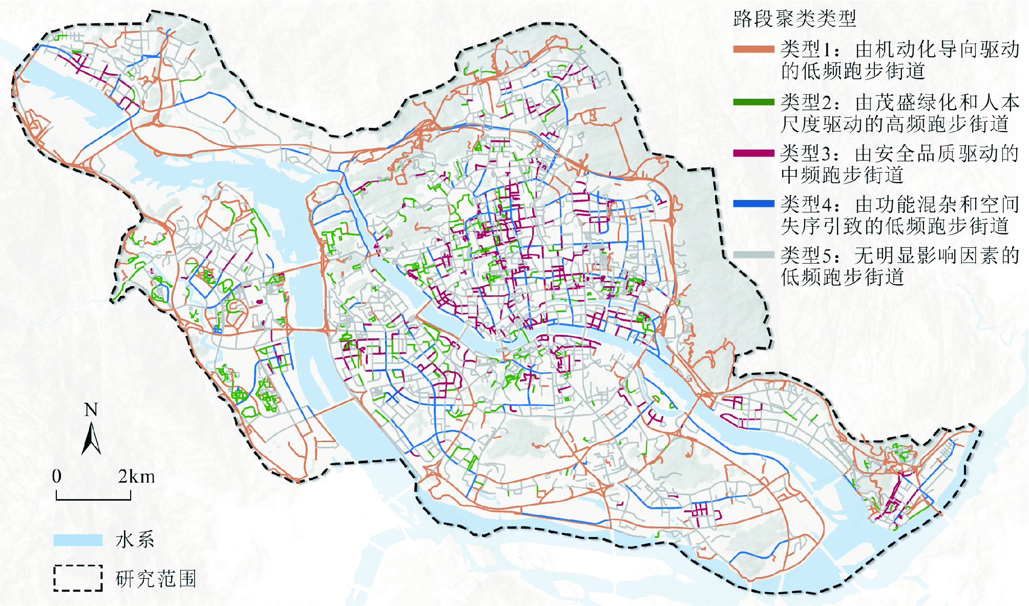
This study aims to address limitations in existing healthy city research, such as the failure to comprehensively measure environmental features (including spatial quality) and the reliance on assumptions of linear relations. It intends to reveal nonlinear and spatially heterogeneous relations between built environmental attributes and running activities. The study area covers the main urban area of Fuzhou. Multisource data, including building profile data, road network data, points of interest, and street-view images, were used. These data were analyzed using spatial statistics and deep learning algorithms, such as semantic segmentation, object detection, and image regression, to develop a comprehensive framework for evaluating urban built environment attributes. This framework incorporates two- and three-dimensional environmental elements as well as spatial quality characteristics. We then employed the Extreme Gradient Boosting algorithm and SHAP explainers to summarize the types of nonlinear relations between built environment features and residents’ running activities. Combined with K-means clustering analysis, we classified street types according to local and spatial heterogeneity in the built environment’s impact on running activity. The results indicate that (1) there are limited differences in the influence of two-dimensional and three-dimensional physical environmental features, environmental subjective perception, and physical disorder of the built environment on running activity. This finding suggests that analyses confined to conventional physical environmental features alone are inadequate for examining environmental effects on health behavior. Notably, factors, such as building density, POI density, POI mixture, greenery visibility, sidewalk visibility, and safety perception, ranked highly in terms of influence intensity. (2) Six types of nonlinear relations emerged between built environment factors and running density. These include: (I-1) a positive relation with an increasing marginal effect (including sky openness and blue visibility); (I-2) positive relation with a decreasing marginal effect (including POI density and street furniture); (I-3) positive relation with a marginal effect that first increases and then decreases (including POI mixture and safety perception); (II-1) negative relation with a decreasing marginal effect (including garbage and distance to parks and green spaces); (II-2) negative relation with a marginal effect that first increases and then decreases (including building density and aesthetic perception); and (III) U-shaped relation with an initially negative effect followed by a positive effect (including street aspect ratio and greenery visibility). Different types of nonlinear relations require different environmental optimization strategies. (3) There is also spatial heterogeneity in the influence of the built environment on running activities. Based on this spatial heterogeneity, street segments in the study area were classified into five types: low-frequency running streets driven by motorization-oriented design (17%), high-frequency running streets driven by lush greenery and human scale (10%), medium-frequency running streets driven by safety quality (12%), low-frequency running streets induced by functional diversity and physical disorder (7%), and low-frequency running streets with no significant influencing factors (51%). The dominant factors influencing or inhibiting running differed substantially across street types. Strategies targeting specific regions should be implemented based on the spatial heterogeneity of the environmental factors.
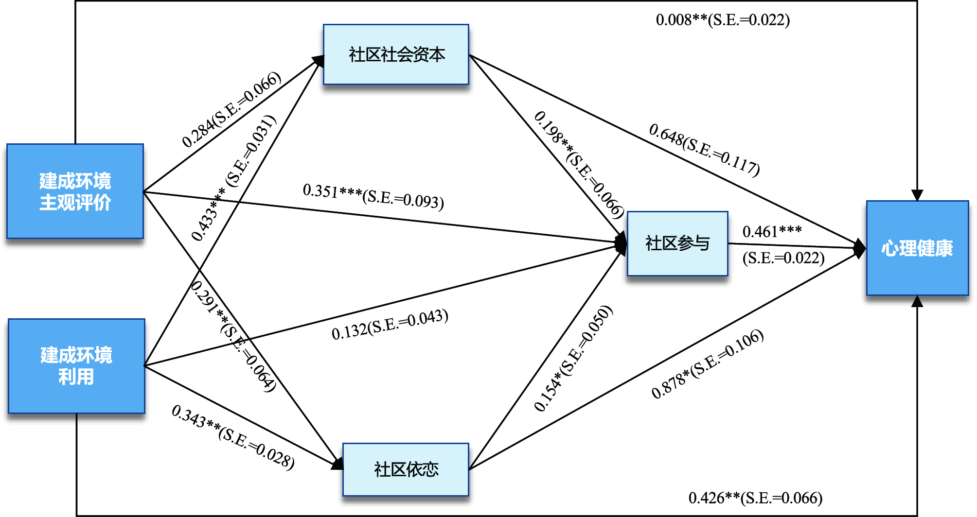
China is currently experiencing an aging population. Moreover, the overall health status of older adults in China remains a concern, with mental health issues becoming increasingly prominent. Early research on older adults’ mental health focused mainly on environmental determinants, particularly the objective characteristics of the built environment. Recently, the impact of the Built Environment Subjective Evaluation (BESE) on mental health has gradually attracted scholarly attention. Most studies have neglected the influence of Built Environment Utilization (BEU) or actual activities occurring in these spaces on mental health outcomes. To address this gap, this study uses data from older adults in 20 communities in Guangzhou, China, and applies structural equation modeling to examine the relationships between BESE, BEU, and mental health among urban older adults, with a specific focus on the mediating roles of social capital, place attachment, and community participation. The results indicate that (1) older adults’ BESE levels show a significant positive correlation with their mental health status, with those with a more positive BEP exhibiting a tendency for better mental health. BEU also demonstrated a significant positive association with mental health among older adults. The BEP significantly affected mental health across all income levels. However, the BEU significantly affected mental health only in the low-income group. (2) Structural equation modeling results showed that both BESE and BEU have significant positive correlations with older adults’ mental health. Notably, compared with the objective features of built environments, older adults’ actual activities in community environments have a more significant impact on their mental health. This indicates that improving older adults' satisfaction with and frequency of using community environments effectively enhanced their mental health. (3) Mediation analysis revealed that place attachment is essential in mediating role between BESE and mental health. Specifically, older adults with higher BESE and BEU scores, potentially because of the intrinsic protective mechanisms of place attachment, were more likely to actively participate in community activities, thereby reporting better psychological states. We found no evidence that strengthening social capital alone can mediate the association between BESE and mental health. (4) The impact of BESE and BEU on the mental health of older adults varied according to age group, education level, and income level. These findings provide practical guidance for developing aging-friendly communities in China. This study revealed significant associations between BESEs/BEUs and older adults' mental health, with utilization behaviors showing more prominent effects. Thus, social capital, place attachment, and community participation play significant mediating roles. This study highlights the need to address internal heterogeneity among older adult populations. Particularly for low-income older adults, planners, designers, and policymakers should prioritize the provision of physical exercise facilities and ensure the safety and comfort of public open spaces.
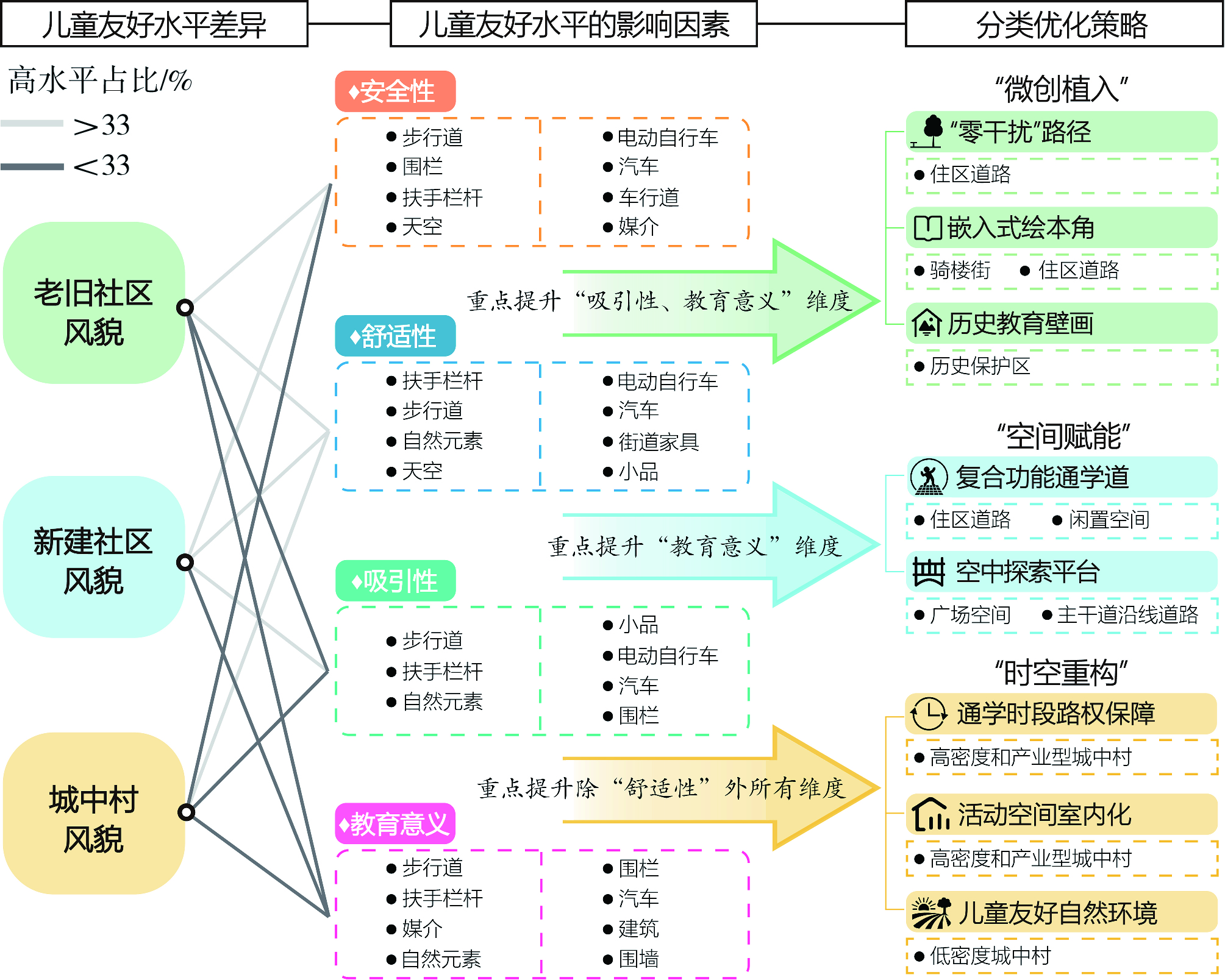
In high-density urban environments, school routes serve not only as essential traffic corridors but also as critical spatial arenas for children’s socialization and urban perception. Existing urban studies largely rely on traditional Google Street View or car-centric perspectives, which inevitably lead to a significant "scale deviation" that fails to capture children’s authentic pedestrian experiences. To address this gap, in this study, a novel micro-environmental assessment framework integrating self-photographed pedestrian views (SPPV) with a method of empathy-based stories was developed. Using advanced semantic segmentation to extract microscale environmental features and integrating random forest with elastic net regression, a large-scale assessment and analysis of driving mechanism underlying child-friendly school routes in Guangzhou were conducted. The analysis yielded significant empirical findings. First, the child-friendliness of school routes in Guangzhou exhibited pronounced spatial differentiation driven by distinct community spatial characteristics, ranking from highest to lowest as follows: newly built communities, old communities, and urban villages. Each community typology exhibits distinct structural shortcomings: newly built communities establish high safety baselines but suffer from rigid car-centric layouts and underutilized spaces lacking educational stimulation; old communities maintain basic comfort but fail to translate historical heritage into interactive assets because of excessive commercial clutter; urban villages function as safety sinks, characterized by extreme high-density “handshake buildings” and severe vehicle-pedestrian conflicts. Second, analysis of micro-element driving mechanisms indicated that high-quality sidewalks and diverse natural elements were the primary positive drivers for enhancing child friendliness. Conversely, micro-level nuisances, such as pervasive e-bike encroachment, chaotic parking, and excessive spatial enclosure, create significant visual pressure and negatively affect children’s perceived safety and comfort. This study offers crucial theoretical and practical contributions. Theoretically, this study addresses the structural bias inherent in adult-centric and vehicle-oriented urban sensing, providing a low-cost, high-precision methodological framework for capturing children’s authentic perspectives. Practically, the findings highlight a pronounced mismatch between adult-led macroplanning and children’s developmental needs. The study concludes that reliance solely on macro-level road network optimization is insufficient. Urban policy and planning must transition from traditional engineering-oriented approaches to human-centric governance. Policymakers are encouraged to adopt a pedestrian-scale perspective by implementing differentiated spatial improvement strategies and enhancing affordance-based design of micro-scale street furniture. Ultimately, this paradigm shift is essential for transforming utilitarian transit corridors into multifunctional public spaces that comprehensively support children’s needs for safe mobility, natural exploration, and dynamic social interaction.
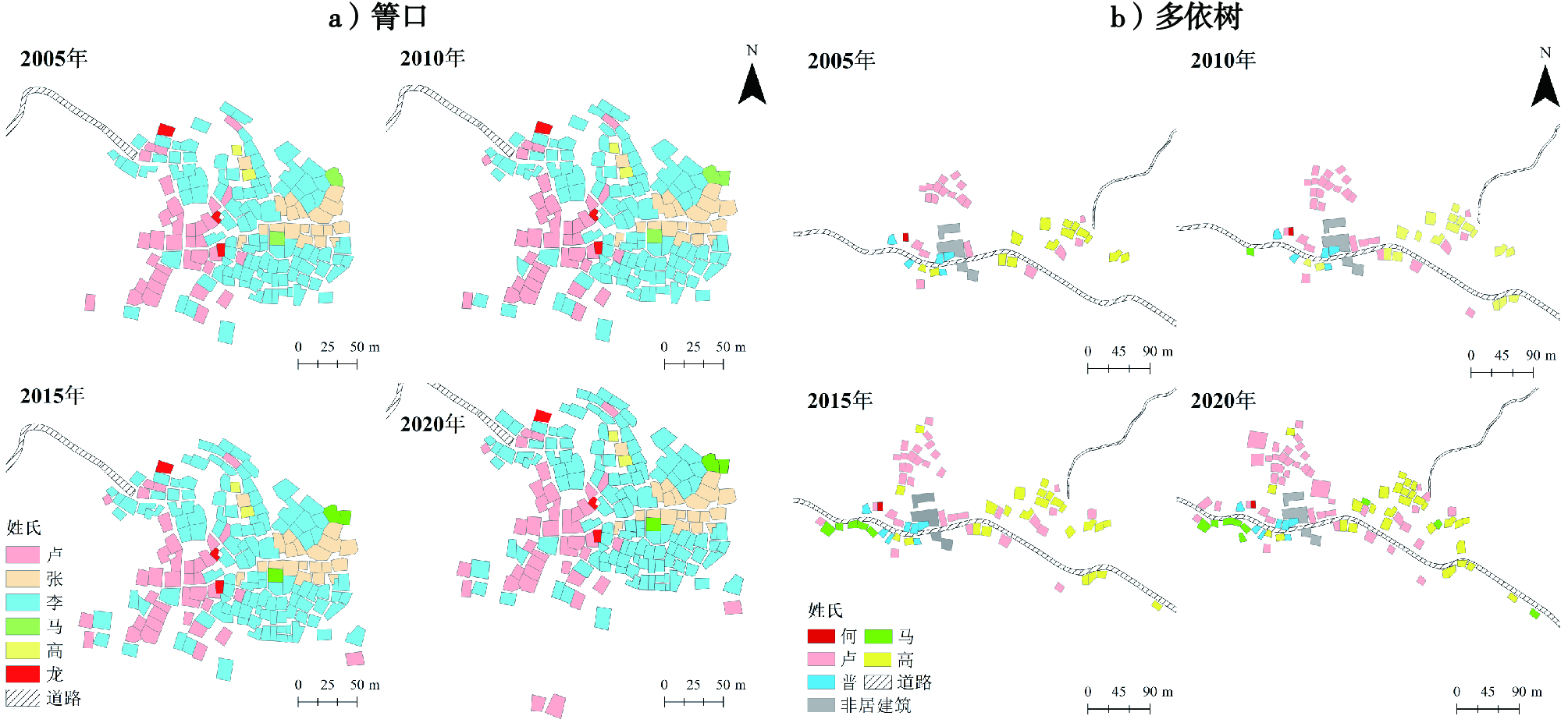
Recently, the roles of social and cultural factors in the spatial evolution of rural settlements have received increasing attention. However, in heritage sites, especially in the Hani terraced areas under the background of tourism development, quantitative research on the influence of clan structure on the settlement space is still limited This study quantitatively verified the role of clan structure and traditional concepts conducted by Hani villages in the core area of the Honghe Hani Terrace Heritage Site in the evolution of settlement space, revealed the internal relationship between clan composition and spatial patterns, and provided a new theoretical basis and differentiated governance path for the sustainable governance of heritage sites. Taking 41 Hani villages in the core area of the heritage site as the research object, four quantitative indicators were used to measure: (1) surname richness, which describes the quantitative characteristics of clans in villages; (2) surname information entropy, which describes the uniformity of clan composition; (3) spatial nearest neighbor index of surname settlements, which characterizes the degree of spatial agglomeration or dispersion of surname settlements; and (4) information entropy of the surname settlement area was used to characterize the degree of equilibrium of the residential land area occupied by different surnames. Correlation analysis revealed a relationship between the clan structure and settlement space indices. Our results demonstrated, as follows: (1) a significant positive correlation between surname richness and the nearest neighbor index of surname settlements. Specifically, the smaller the richness of surnames, the smaller the nearest neighbor index, and the more concentrated the settlement space. In contrast, in villages with rich surnames, the settlement space tends to be scattered. (2) A significant positive correlation between surname information entropy and surname settlement area information entropy. The smaller the surname information entropy of the village (that is, the more single the surname composition), the more unbalanced the settlement area of each surname—manifested as the single clan occupying most of the settlement land. In villages with larger surname information entropy, the area distribution of each surname is more balanced. (3) Although tourism development has a certain impact on the settlement pattern of villages, villages with a single clan composition can still maintain significant spatial aggregation characteristics. Additionally, villages with balanced clan composition are more susceptible to external factors, such as transportation facility construction, thus breaking through the traditional spatial pattern and changing from an aggregation mode to a decentralized mode. Research conclusions: Clan structure is a key factor affecting the evolution of village settlement space in the Hani Terrace heritage site. The traditional concepts of cohabitation, village identity, and degree of integration between clans have jointly shaped and continued the evolutionary path of the spatial pattern. Single-clan villages show strong spatial resilience, whereas clan-balanced villages are more sensitive to external intervention. This study quantitatively reveals the correlation between clan structure and spatial pattern of settlements, and provides an operable analytical tool and empirical basis for the differential governance of heritage sites.
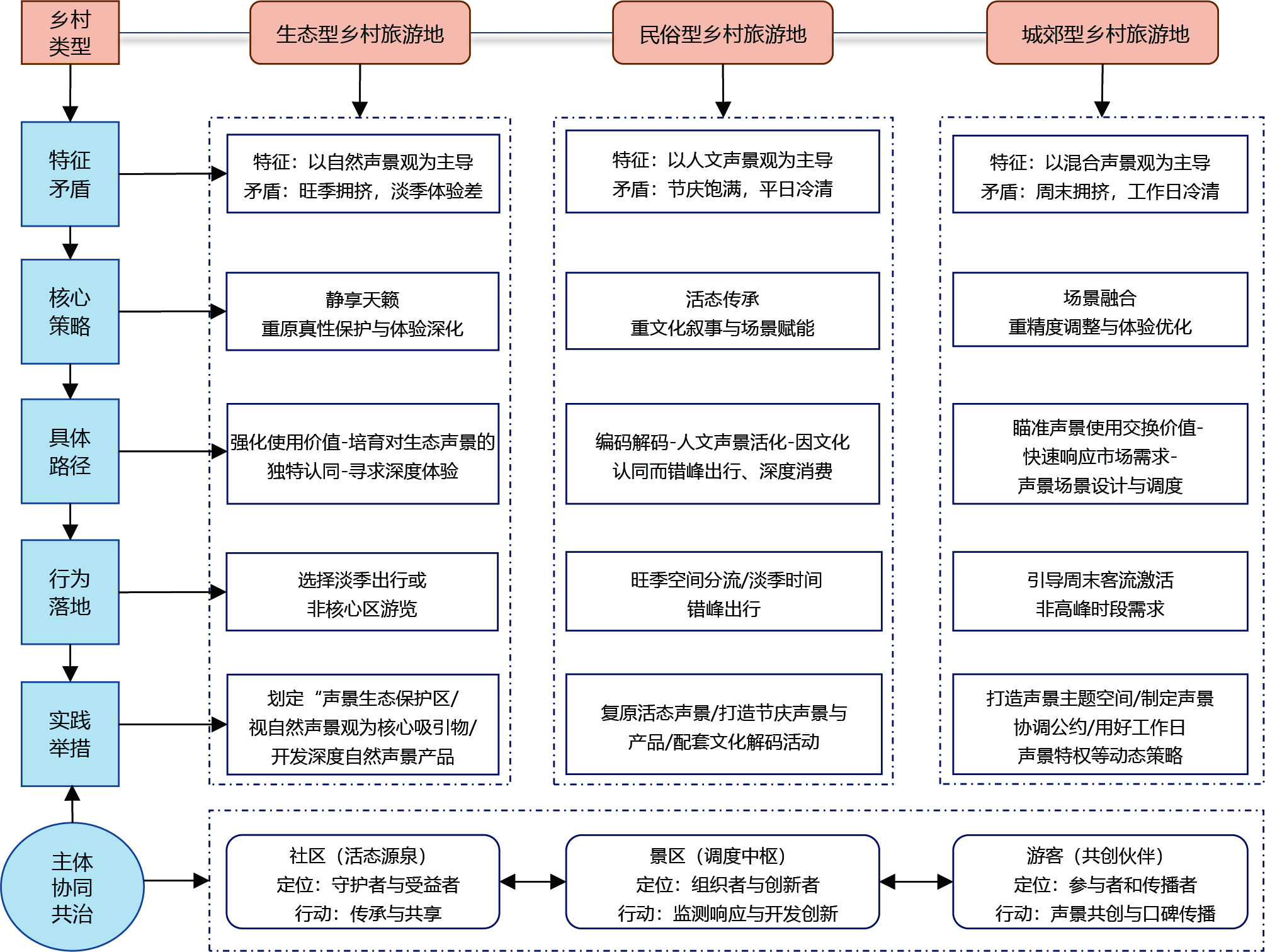
The "tidal phenomenon" of tourist flows in rural destinations—characterized by peak-season overcrowding and off-season stagnation—poses a critical barrier to sustainable development. Conventional hard strategies, such as capacity expansion and price regulation, are often inefficient and may undermine local authenticity. The soundscape, as a largely overlooked form of sensory capital, offers potential to flexibly guide tourists’ spatio-temporal behavior; however, its underlying mechanisms remain unclear. This study integrates sensory capital, cultural acoustics, and spatio-temporal fix theories to construct a "value-meaning-practice" framework, aiming to elucidate the core pathways and differentiated strategies for soundscape-based mitigation. A multi-case qualitative design encompassed six rural destinations in China: Yuantang Terraces and Libo Zhangjiang (ecological), Yongding Tulou and Dangjia Village (cultural-heritage), and Moganshan and Zhanqi Village (suburban). Data were collected through participant observation (7-15 days per site), in-depth interviews (80 respondents; approximately 120,000 words), and textual analyses (327 User-Generated Content (UGC) items and official documents). The analysis followed a three-stage coding process using NVivo 12 until theoretical saturation was achieved. The results revealed a three-stage progressive pathway—sensory capital activation, cultural acoustics empowerment, and spatio-temporal fixation—embedded within a self-reinforcing feedback loop. At the sensory capital activation level, natural soundscapes generate use value through stress reduction and attention restoration, extending tourists’ average dwell time at Yuantang Terraces by 20 min. Humanistic soundscapes generate symbolic value through nostalgia and participatory engagement. Elderly tourists in Dangjia Village planned winter return visits triggered by traditional peddlers’ calls, while younger tourists developed a sense of belonging through interactive drum performances. Soundscapes also carry exchange value as information carriers: the "rice paddy frog calls" short video in Zhanqi Village directly prompted off-season bookings, while off-season mountain singing in Yongding Tulou encouraged off-peak recommendations. At the cultural acoustics empowerment level, local communities encode productive and everyday soundscapes (e.g., rammed earth chanting symbolizing solidarity and morning pestle sounds reflecting a grain-cherishing philosophy). Tourists decode these sounds through generational, urban-rural, and cultural distance lenses, thereby fostering deep place attachment. Drum sounds initially perceived as "noisy" were reinterpreted as “powerfully beautiful” after tourists learned about their historical military and harvest functions. This internalization translates into three behavioral outcomes: off-season intention (e.g., Moganshan winter bamboo-listening participants expressed a willingness to revisit during the off-season), consumption desire (e.g., purchasing soundscape-themed teaware as memory vessels), and enhanced sharing motivation (e.g., UGC related to weaving sounds achieved significantly higher interaction rates than conventional landscape photographs). At the spatio-temporal fixation level, spatial diversion during peak seasons achieves a geographical fix: zoning of Yuantang Terraces into quiet listening and interactive areas reduced core-area crowding by an estimated 28%, while drum sounds in Dangjia Village acted as an "acoustic lighthouse," guiding tourists toward peripheral alleys. Temporal staggering during the off-season achieves a temporal fix: Libo Zhangjiang’s "summer night firefly stream soundscape" narrative increased off-season visitation by 35%, while Moganshan’s soundscape membership system (off-season points redeemable for peak-season privileges) cultivated stable off-season visitation habits. This process forms a self-reinforcing loop—"deep experience → identity reinforcement → active off-peak behavior"—providing endogenous momentum for long-term visitor balance. The mechanism exhibits differentiated emphases across rural types: ecological villages prioritize use value and restorative experiences; cultural heritage villages emphasize symbolic value and cultural authenticity; and suburban villages prioritize exchange value and flexible scene construction. The essence of soundscape mitigation lies in a systematic socio-cultural process of "sensory activation → cultural identification → spatio-temporal restructuring," with its feedback loop ensuring sustainability. The theoretical contributions are twofold: first, the study introduces an auditory dimension into sensory capital theory by operationalizing a three-dimensional value system and demonstrating how soundscapes guide spatio-temporal decisions through physiological, emotional, and cognitive pathways, thereby challenging the visual-centric bias in tourism geography; second, it establishes a cultural interpretative pathway for spatio-temporal fixation theory by demonstrating that soundscape-based cultural narratives constitute a non-economic fix, thereby extending the theory’s application from capital logic to sensory-cultural governance.
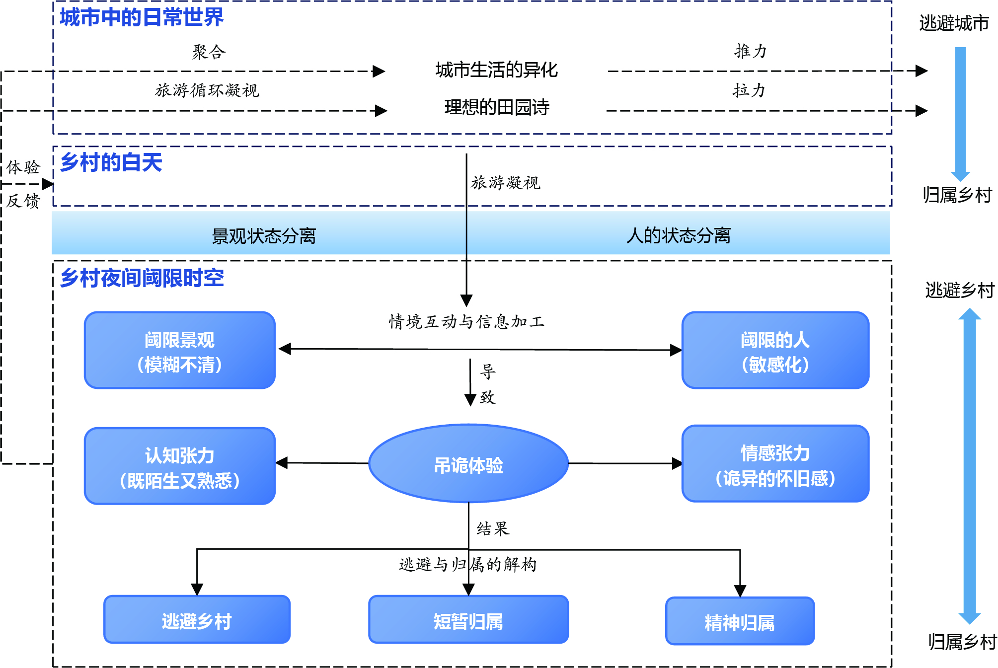
The advancement of modern industrialization and urbanization has intensified survival pressure and existential crisis among urban residents, causing alienation and estrangement, alongside convenience. These conditions generate motivations to temporarily leave cities and pursue belonging. Rural tourism has emerged as an attractive option to counter urban alienation, yet existing research largely treats rural tourism as a whole or emphasizes daytime settings, focusing on positive impacts while neglecting day-night differences. Despite growing popularity, rural nighttime tourism remains underdeveloped, with many tourists departing after daytime activities. Understanding experiential patterns is therefore essential before advancing rural nighttime tourism products. This study examines the nighttime dimension of rural tourism, analyzing urban tourists’ experiencing as the primary consumer groups. Data were collected from online texts (travelogues and reviews) and semi-structured, in-depth interviews and then analyzed using grounded theory coding Findings reveal that rural nights constitute a liminal spatiotemporal process, marked by dual transformations: spatial (urban→rural) and temporal (day→night). Specifically: 1) At nightfall, rural landscapes shift as natural features gain prominence while cultural landscapes and conveniences diminish, producing ambiguous spaces distinct from urban cycles and rural daylight. Tourists, in turn experience heightened multisensory perception, anonymization, and subconscious exposure, becoming sensitized "liminal beings". 2) Within this liminal space-time, cognitive tension arises through simultaneous familiarity and unfamiliarity, forcing trade-offs between adventure/risk and safety/boredom. Emotional tension combines nostalgia and fear, expressed through nostalgiacore (nostalgia-oriented), dreamcore (ambiguous), and weirdcore (fear-oriented) sensations. 3) These dual tensions generate both positive and negative outcomes, deconstructing the initial "escape-from-city, belong-to-countryside" motivation. The objects and intensity of escape/belong motivations dynamically transform, creating a paradoxical desire to both escape from and belong to rural settings. Outcomes include temporary belonging through utilitarian or flow experiences, spiritual belonging through identity reinforcement and poetic creation, and escape driven by negative encounters and reliance on urban modernity. The paradoxical orientation of rural night experiences represents a distinctive form of liminal experience. Ambiguity in rural nightscapes serves as the source of meaning, while tourists’ sensitized states provide the cognitive pathway. Perception of tension is the core process of the paradoxical orientation, while the deconstruction of escape and belonging is the final experiential result. By developing a theoretical model, this study highlights the fluidity of liminal space-time, reveals paradoxical orientations, and deepens the understanding of the multidimensional nature of rural tourism experiences.
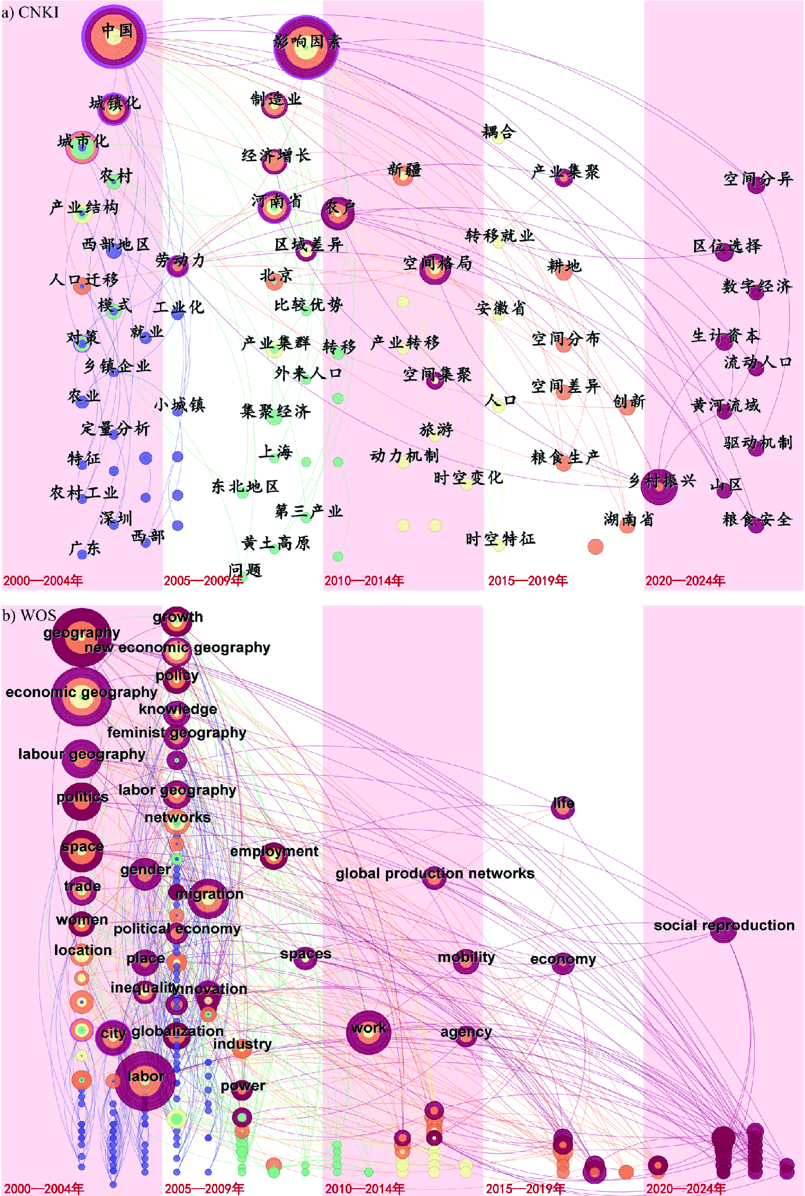
Labor geography has become a focal point in geographical research because of its unique analytical lens on the spatial dynamics of labor and its interaction with economic geographical patterns. However, existing studies lack a systematic review of research hotspots in this field, both domestically and internationally, and fail to conduct in-depth comparisons of their differences or explore their underlying causes. To address this gap, this study employs CiteSpace to map research hotspots and the evolutionary trajectory of labor geography by analyzing high-quality Chinese and international literature since 2000, while comparing the similarities and differences between domestic and international research in this field. The results show that research in China has primarily examined the spatial distribution and migration trends of the labor force at the national, regional, and urban scales. It also focuses on mechanisms by which labor influences regional development during industrial upgrading, how industrial segmentation shapes the labor market, and disparities in employment characteristics. Owing to the distinctive urban-rural dual structure in China, issues related to the rural labor force have become research hotspots. Foreign labor geography also focuses on the spatial distribution of the labor force and emphasizes the key concept of "labor mobility," that is, behaviors of adaptation, resistance, and reshaping exhibited by the labor force at different spatial scales during economic activities. Foreign research also examines local governance of the labor market and considers immigrant and refugee labor in the process of globalization as important research objects. Additionally, issues of employment inequality affecting female and ethnic minority laborers have received close attention. Although Chinese and foreign research exhibit convergence in certain thematic hotspots, differences in academic environments, market mechanisms, and data foundations have led to divergence between Chinese and international scholarship. Research in China demonstrates characteristics typified by a practical emphasis with relatively limited theoretical grounding, a policy-driven thematic orientation, and a predominant reliance on quantitative methods. By contrast, foreign research is characterized by a critical stance in theoretical foundations, diversified thematic development, and a methodological approach integrating qualitative and quantitative techniques. Since 2000, Chinese and international labor geography research has shown clear evolution across four key dimensions: research participants, thematic foci, analytical scales, and methodologies. Concurrently, intellectual exchange and mutual learning between these research communities have intensified. Against the backdrop of globalization entering a phase of adjustment, future research in labor geography needs to balance Chinese and international perspectives, strengthen theoretical dialogue, explore the applicability of Western theories to specific domestic issues in China, deepen understanding of interactions between global production networks and local labor markets, and investigate the impact of social networks and technological transformations on labor spatial patterns. This study provides not only an informed frame of reference for comprehending the far-reaching influence of labor on development and its spatial dimensions but also a significant basis for fostering a more globally dialogic research paradigm in labor geography.