This paper situates Chinese human geography in the context of a decentering and globalizing world in which China has been firmly integrated. It is believed that the recent disturbing interventions of protectionism and Sino-American disputes have had the effect of slowing down but not reversing the long-term trend of intellectual globalization. Chinese human geographers should never be discouraged from entering the world stage and should instead take on the new challenges and opportunities for critical theoretical engagements and research innovation. A comparative assessment of Chinese human geography and its Western counterparts has identified common traditions and shared heritage in terms of subject matter, research frameworks, and routes of explanation. Whereas Chinese human geography is found to be more disciplined, organized, coherent, and supportive of state developmental agenda, human geography in the West is characterized by individual freedom, greater diversity, blue-sky enquiry, and a critical perspective free from any mandate that serves the interests of governments. Three ideological positions are identified for Chinese human geographers to use as important perspectives to engage in theoretical critique. Other possible ways of theoretical engagements include situating the problem in a different time and space, reassessment using different data and methods, challenging the basic assumptions upon which the theory is built, questioning cause-effect relationships, and (re) examining the issue on a different scale. Research innovation can be facilitated by a better understanding of three different kinds of geographic knowledge; establishing a research assessment system conducive and sufficiently stimulating; working at international research frontiers and interdisciplinary interfaces; promoting comparative studies; and utilizing research methods of different fashions. Three possible scenarios are envisioned for Chinese human geographers to venture into a future filled with new challenges and opportunities.
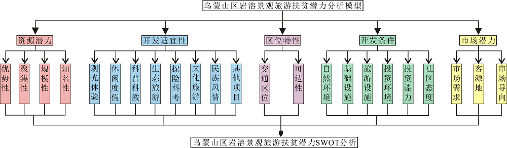
Wumeng Mountains is a short term for the continuously and particularly impoverished area in the Wumeng Mountain region. More than 200 important and typical karst landscape resources, which are widely distributed in different karst areas, have been discovered to present in the Wumeng Mountains. There is a complete range of karst landscapes in their typical forms, including mountains (peak clusters, peak forests, cuestas, hills, pictographic mountains, dome mountains, etc.), gorges (including Difeng), mountain gorges, natural bridges, stone forests, pillar-like peaks, cliffs, platforms, denudation surfaces, depressions (valleys), dolines, plains, basins, poljes, caves and various speleothems, light-through caves, tiankeng, karst windows, shafts, underground rivers, waterfalls, lakes, springs, wetlands, forests, cultural landscapes, and more. This study analyzed and examined many factors of the Wumeng Mountains, including the social economy, poverty alleviation status, natural environment, and regional geological settings, as well as the karst features, to discuss the karst landscape types and distributions systematically, assess the karst tourism potential for poverty alleviation through an analysis of the resources potential, suitability for development, regional features, development conditions, and market potential, and finally define the correlation between karst tourism potential and karst features. The study reached the following conclusions: 1) The Wumeng Mountains region includes numerous karst landscapes, with typical forms, that cover all of the types of karst landscapes and comprise 118 individual karst landscapes or karst landscape areas with different levels of advantages (including 78 provincial-level and 32 national-level and international-level karst landscape areas and many county-level individual karst landscapes or karst landscape areas). These individual karst landscapes or karst landscape areas form a stable pyramidal resource structure and are distributed in county-karst areas with different characteristics of solubility (that is, strong, easy, and weak solution conditions) that are located in three karst districts of Yunnan, Guizhou, and Sichuan Provinces and are classic concentration areas and outstanding representatives of plateau karst landscapes in the world. They present different types of landscapes and reflect obvious regional features and advantages. 2) In general, with gradual lowering of the karst landscape distribution density (from 39.13 to 19.58 and 4.91 items per ten thousand square kilometers), weakening of solubility (from strongly soluble to easily soluble and weakly soluble areas), and reduction of landscape area level (from international level to national level, provincial level, and county level), the three continuous karst areas in Guizhou, Yunnan, and Sichuan and each county-level karst region, as well as each individual karst landscape or landscape area, have progressively lower advantages, concentrations, scales, and popularities, which accordingly result in gradually diminishing tourism potential for poverty alleviation. 3) The most suitable and dominant tourism products with the greatest number of advantages and greatest development potential for the Wumeng Mountains are sightseeing and leisure, and the Wumeng Mountains could be established as a sightseeing and leisure tourist destination for caves, mountain gorges, Difeng, karst windows, natural bridges, tiankeng, waterfalls, and lakes, which has international-level advantages. 4) The regional features, development conditions, and market potential of the Wumeng Mountains are obviously inferior to those of other similar karst regions. Finally, the study proposed five karst tourism modes for poverty alleviation, i.e., sightseeing and leisure tourism, ecological tourism, scientific tourism, cultural tourism, and scientific exploration. Additionally, the study evaluated guaranteeing mechanisms of karst tourism for poverty alleviation through aspects such as government, infrastructure, regional tourism development, regional cooperation, and development concept.
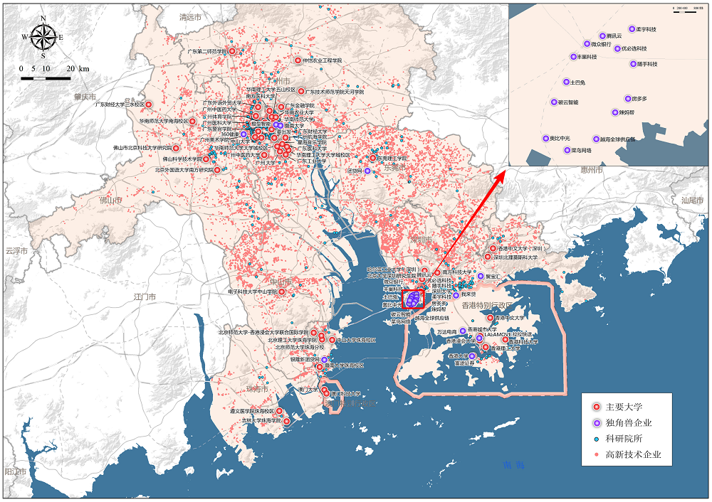
As capital’s pursuit of knowledge has become an increasingly significant global trend, scientific and technological innovations have gradually replaced the development mode of factor-driven and resource consumption, supporting as the driving force of economic development in the new era by influencing the industry transformation and promoting new formats, along with fundamentally guiding the transformation of the leading functions of cities or regions toward scientific and technological innovation. Furthermore, the economic competition among cities or regions around the world is more prominently manifested in the competition of science and technology. As the embodiment and core support of a country’s comprehensive scientific and technological strengths, a scientific and technological innovation center could play a significant value-added role by occupying a leading, dominant position in the global value grid. This is an important measure for many countries and regions to cope with the challenges of each new round of scientific and technological innovations. Moreover, it also enhances national competitiveness. Based on the discussion of global innovation patterns and trends, as well as the interpretation of the connotation and characteristics of international technology innovation centers, this paper analyzes the advantages and challenges that the Guangdong-Hong Kong-Macao Greater Bay Area might face in constructing a global technology innovation center, and some strategies are suggested for the future development. At present, the Guangdong-Hong Kong-Macao Greater Bay Area are in a period of entering knowledge economy as a whole, wherein innovation elements are highly concentrated geographically, and innovation ecological conditions are constantly improved. The impact of innovation globalization is emerging in this region, and the demand for innovation is as strong as the manufacturing industry foundation within this area. The basic conditions for the construction of an international science and technology innovation center are sufficient. However, owing to institutional obstacles in integrating Guangdong-Hong Kong-Macao Greater Bay Area and the huge intra-regional gap, some practical challenges in innovation development of this region still exist, such as the disconnection of innovation elements, the unsmooth internal flow of innovation elements, the difficulty of system-mechanism transformation, and the dilemma of relying on importation of core technologies. To take benefit from the favorable characteristics of Guangdong, Hong Kong and Macao, and mitigate any inherent shortcoming, the construction should be based on the establishing of a hotbed of international industrial innovation. In the meantime, this region should choose the construction of an international industrial science and technology innovation center as its core priority. This will accelerate institutional innovation and consider the construction of collaborative innovation demonstration zone as the key to breakthrough. Boost industrial innovation by enhancing the ability of original innovation, promote collaborative innovation by institutional reform, and finally realize the coordinated and integrated development of Guangdong-Hong Kong-Macao Greater Bay Area’s innovation.
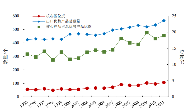
China’s foreign trade has developed rapidly since the reform and opening up. After joining the WTO in the early 21 st century, China’s export economy has risen to unprecedented levels. In the past few decades, processing trade and “compressed industrialization” have changed China’s comparative advantages and export structure. However, with the increase in production costs, China's traditional industrial pattern can no longer sustain its development. Exploring China’s industrial evolution and studying its internal influence mechanism have great significance in responding to the challenges. Different from traditional research that studied export evolution by describing its quantity and structure at the macro level, the popular evolutionary economic theory “Product Space” adopts a network perspective to study industrial evolution at the micro level and thus, makes a breakthrough in economic geography. Product upgrade is essentially a process wherein a region shifts to new, related products in the product space. Therefore, this article uses global customs data for 2000-2011 to construct a dynamic product space. Some scholars have proposed the idea that developed countries tend to produce core products, and products located in the core area of the product space can move to nearby regions more easily than those in the periphery. However, there is no unified quantification to measure countries’ core-periphery location in the product space yet. Many existing proxy variables are related to economic attributes and there may exist endogeneity problems in measuring productivity. First, our article proposes an exogenous indicator, “core location,” based on the topology structure of the space network. The regression model indicates that our indicator is reasonable and confirms that a country’s location in the product space does indeed affect its economy. Then, we analyze China’s evolution in terms of the overall export pattern and export location in the dynamic product space. Results show China has changed its traditional specialized pattern to an increasingly balanced pattern, and its “core location” is becoming bigger, which means it is gradually crawling toward the core area. Compared to other countries, China ranked at the top on the changing range of “co-location”. Finally, we analyze the influence mechanism of China’s location evolution in the product space. We find that human capital is the dominant impact factor of China’s location evolution. Education and R&D investment, as the main aspects of human capital, can increase knowledge spillovers and promote innovation, which in turn generates technology progress and industrial upgrading. It is interesting that foreign investment does not really have significant potential to help China move to the core area in global trade.
Urban spatial layouts with leaping disorderly growth and far too compact shrinkage conflict with scientific and sustainable urban development processes to a certain extent. How to realize reasonable and moderate urban smart development has become a popular research topic in several disciplines in recent years. Using a data source retrieved from “China Knowledge Resource Integrated Database” and “Web of science,” we analyze literature published between January 2000 and May 2019 that focused on urban smart development using the visual analysis tool CiteSpace V. We also drew corresponding maps of knowledge structure in domestic and foreign countries using co-occurrence and cluster analysis of key words, identification and analysis of burst words and frontier paths, analysis of collaborative networks of authors and institutions, and network analysis of publication periodicals. Moreover, we analyze and provide detail on comments related to aspects such as theoretical connotation, quantitative measurement, and practical application of urban smart development research. The findings of this study demonstrate the following: First, a research network for a whole new field of urban smart development study has come into existence, and in contrast, knowledge structure network tightness needs to be further strengthened in domestic and foreign countries. Second, many clustering knowledge groups of research themes exist around the world, and the yearly evolution path of key word co-occurrence clustering is relatively long and occurrence times are relatively scattered, which does not indicate powerful flowing time zones and succession venation. Third, research hot spots and forward positions gradually revert to the application of microscopic aspects and urban shrinkage tendencies from a macroscopic theoretical analysis in China. Researchers worldwide cover a widespread subject background but have loose inter-citation, thus communication and discussion must be strengthened urgently. Research institutions in China have detailed and extensive discipline divisions, and in addition to this, there are significant regional scientific research ability differences when taking the eastern region and municipality of Beijing as a priority. Lastly, urban smart development research in economic management, sustainable development, geography, architectural science, and engineering in China has achieved remarkable results. We suggest that strengthening the definition of connotation and construction of judgment frameworks and taking deep consideration of multi-angle forward positions while further promoting academic communications between authors and research institutions is greatly significant to improve the degree of correlation of research networks. As a result, these changes would form a more extensive research network and knowledge structure system.
With the deepening of urbanization, new-generation migrants are returning, leading to backflow population. Few studies have explored this emerging phenomenon in urban China. However, majority of the researchers have focused on return behavior based on the “pull-push forces” theory defined by national and urban macro-factors. Less attention has been paid to the individual factors that cause migrants’ return, e.g., social ties and capital, perceived discrimination and exclusion, social integration, and place attachment. To fill this gap, this study examines the determinants of the new-generation migrants’ return intentions and location choices based on the following two micro-level aspects: “objective attributes” and “subjective perceptions.” Using the data collected from the 2014 National Floating Population Dynamic Monitoring Survey and binary and multiple nominal logistic regression models, this study focused on three types of new-generation migrants (born after 1980): skilled migrants, business migrants, and labor migrants in four cities (Beijing, Shenzhen, Chengdu, and Zhongshan). The results can be given as follows. 1) New-generation migrants in urban China exhibited a strong intention to return, and their location choices differed based on their types. Further, 40% of migrants returned to their household region. Labor migrants exhibited the strongest intention (43.7%), followed by business migrants (36.0%) and skilled migrants (27.9%). Proportionately more skilled migrants planned to return to provincial capitals or prefectural cities when compared with the other two cohorts. 2) Binary logistic models identified return determinants; new-generation migrants’ returning intentions were influenced by both the “objective attributes” (demographical and economic condition) and “subjective perceptions” (economic position perception and sociopsychological perception). Males exhibited a greater probability of returning when compared with that exhibited by females. Age, education level, monthly income, and years of leaving hometowns were negatively related with the migrants’ return intentions. Long working hours per day contributed to their return. No evidence has shown that the marital status, number of children under the age of 18, or contract form were significantly related. As for the subjective factors, migrants with high family-related mental burdens and strong native cultural identification were increasingly likely to return. Strong social acculturation caused new-generation migrants to settle down in their destination cities. Importantly, there was no direct link between the migrants’ return intentions and perception of economic position. 3) Regarding determinants in local choices, education level was the most significant factor associated with migrants’ backflow to provincial capitals. Sociopsychological perceptions strongly influenced their backflow to prefectural cities. Demographic factors, such as gender, age, and years of leaving hometowns, exhibited a close relation with returning to counties or townships. Notably, migrants with high monthly incomes exhibited a greater probability of returning to urban settlements when compared with rural areas. This study confirmed that individual factors, particularly sociopsychological perceptions, have an important effect on the new-generation migrants’ return behaviors in urban China. Therefore, we initially call for the government to articulate the significance of social acculturation and integration, targeting the new-generation migrants to avoid “reverse culture shock” in backflow settlements, notably in prefectural cities. Second, the improvement of public services, such as medical care, pension, and children enrollment opportunities, as well as favorable policies and practices should be considered in urban development and planning and established to relieve the migrants’ family burden.
In recent years, the driving force behind PM2.5 concentrations has been extensively investigated. Most existing literature has focused on the socioeconomic impact factors that contribute to PM2.5 concentrations; however, the importance of institutional background is ignored. During the period of economic transformation, marketization, decentralization, and globalization were the three important institutional processes in China; these processes were considered as the key factors that contributed to pollution. Therefore, the existing literature separately focuses on the socioeconomic activities and institutional background. However, the interaction effect of these factors on air pollution remains understudied. Therefore, the interaction effect of socioeconomic activities and institutional background on PM2.5 pollution in Guangdong Province, which is the frontier of China’s economic reforms and transformation, must be investigated. Using the PM2.5 concentration data obtained from remote sensing images, spatial Markov chain analysis was performed herein using a spatial econometric model to analyze the spatial- temporal pattern of PM2.5 concentrations and its driving factors. Following results were obtained: 1) the PM2.5 concentrations in the Guangdong Province first increased and then decreased. Over the past 18 years, the PM2.5 concentrations have increased by an average of 55.47%. PM2.5 concentrations in the seven prefecture-level cities in the Pearl River Delta region were within the first-level standard of 35 μg/m 3 according to the Ambient Air Quality Standards. 2) The PM2.5 concentrations showed a spatial distribution structure circling around the Pearl River Estuary and presented a diffusion pattern, followed by concentrating spatial-temporal evolving trend whose variation core is situated in Foshan, Guangzhou, and Dongguan cities. Spatial Markov chain analysis result identified a spatial spillover effect of PM2.5 concentrations in Guangdong Province. If a region is adjacent to the regions with high PM2.5 concentrations, then the probability of PM2.5 concentrations increasing in that region will be high. However, if a region is adjacent to the regions with low PM2.5 concentrations, the probability of PM2.5 concentrations decreasing in that region will be high. 3) Based on the Spatial Lag Model, we examined the interaction effect of institutional background and socioeconomic activities on PM2.5 concentrations after controlling the spatial spillover effect. Empirical results indicate the existence of an environment Kuznets curve during the economic development in Guangdong Province. Overall, pollution-intensive industrial production is one of the most important factors promoting PM2.5 emissions; energy-related technological improvement can significantly lower the PM2.5 concentrations. Marketization has a positive relation with PM2.5 concentrations because the ratio of non-state owned industry rose remarkably and reached 96.8% in 2015; however, regions with a high degree of marketization can weaken the positive effects of industrial production on PM2.5 concentrations. The reason is that a better market order has more stringent environmental standards and requires enterprises to have higher resource-utilization efficiency, which enable to emit relatively few pollutants during the industrial production. Excessive amounts of PM2.5 pollutants can be generated via industrial production during decentralization and the PM2.5 discharge from pollution-intensive industrial production can be reduced because of the “race-to-the-bottom” effect. PM2.5 pollution was reduced because of the introduction of clean technologies during globalization. Based on environmental regulations and global market demands, PM2.5 concentration can be reduced by reducing industrial emissions and incentivizing technological progress.
A study on the spatial distribution and the format difference of large-scale retail business facilities is always essential to the optimization of urban business resources, and using POI (Point of Interest) data instead of traditional survey data increases the preciseness and reliability of the results of such a study. Therefore, taking Guangzhou as an example, based on large-scale retail business facilities POI data and using spatial econometric methods, this paper analyzes spatial distribution characteristics and the influencing factors of the overall distribution and the different format distribution of large-scale retail business facilities to improve relative studies of large-scale retail business facilities and to promote the targeted planning of large-scale retail business facilities further. The results of the case study are as follows: 1) Regarding the spatial distribution characteristics, generally, large-scale retail business facilities in Guangzhou form a multi-central agglomeration, and the degree of agglomeration decreases from the downtown area to the periphery. In addition, large-scale retail business facilities are distributed along the main roads, connecting important business areas to each other. Moreover, they are obviously adjacent to the metro stations in the city center but are not so obvious in the whole city because the city metro system is incomplete. There are differences in the distribution of the three different retail formats. Large-scale shopping malls are distributed mainly in the city center and in the sub-centers of the city and are more adjacent to the metro stations than the other two formats are. The distribution of large-scale supermarkets diffuses from the downtown area to the periphery. Large-scale specialty stores are distributed mainly in the periphery of the downtown area and are more adjacent to the main roads than the other two formats are. 2) Regarding the influencing factors, population, economic development, and rent have a significant effect on the overall distribution and the distribution of the three retail formats. The factors influencing the different formats also have differences. Distance to the city center has a positive impact on both the distribution of large-scale supermarkets and large-scale specialty stores, meaning that their distribution prefers farther location from the city center. Rent has a positive effect on the overall distribution and the distribution of large-scale shopping malls. Road density and proximity to life centers have a positive influence on the distribution of large-scale supermarkets, while proximity to industrial parks and specialized wholesale markets has a positive effect on the distribution of large-scale specialty stores. According to these results, the planning of large-scale retail business facilities should make efforts to meet the different demands of the different retail formats. The efforts include building more large-scale shopping malls in the periphery area with a growing population and rich land resource, building more large-scale supermarkets in the neighborhood of new life centers, and building more specialty stores near relative industrial parks and specialized wholesale markets properly. Through these efforts, the planning of large-scale retail business facilities can be promoted in a more detailed and more effective way.
The fine-scale spatial distribution of a population can provide assistance for decision-making regarding research, such as urban planning, economic decision-making, disaster prevention, and crime management, which is of considerable importance to the study of human activities. Considering Guangzhou as an example, this study constructed a population spatialization index system based on NPP/VIIRS night light intensity, land use, points of interest (POI), and other natural geographical and socio-economic factors. Further, the principal component weighting method was used to calculate the weight of the population distribution. According to which, geographic information system (GIS) technology was used to assign census data to each pixel. Finally, an accuracy test was performed by comparing the result of the population spatialization with the real population of townships of Guangzhou. The result of the population spatialization, considering natural geography and socio-economic factors, is consistent with the real population spatial pattern, and the spatial resolution is 30 m. The accuracy test result showed that the absolute relative error of 62 townships was less than 25%, which accounted for 36.47% of all townships in Guangzhou, indicating that the result of the population spatialization is highly accurate. The population spatialization result without POI data showed that the absolute relative error of 33 townships was less than 25%, which accounted for 20% of all townships in Guangzhou, showing that the accuracy of population of the spatialization result was significantly reduced. Compared with other studies on population spatialization, this study included the following characteristics: 1) a comprehensive consideration of NPP/VIIRS night light intensity, land use, POI, and other natural geography and socio-economic factors, which are helpful for achieving high-precision results of population spatialization and 2) POI data that can reflect surface features, such as urban land use types and population activity preferences. Additionally, POI data are easy to acquire, rich in data volume, have a high positioning accuracy, and have a better resolution regarding micro details. Introducing POI data into population spatialization research can expand the data source of population spatialization and improve the accuracy of population spatialization results.
Major Function Oriented Zoning (MFOZ) is a part of the national land space development and protection system and is the main basis for other special space development and layout plans; further, it plays a role in strategic planning and target transmission in the spatial planning system. The study area is the city of Guangzhou, China, and based on a 96.6% matching rate for the interest point (POI) data, the village-level administrative unit is selected as the basic calculation unit of the study. Functional land type identification is performed using a deep network convolutional neural network, and semantic extraction of the remote sensing images is conducted. The extraction results and the POI data function land obtained by the sample density method undergo data reclassification and are assigned to an assignment model. The result is supplemented and verified. In accordance with the relevant policies and planning documents, an association is established between the functional land and the MFOZ, and the rules of interpretation for the functional area and MFOZ are developed. As the POI data is peculiar, an information entropy method with quantitative metric elements is used to analyze the degree of mixing of functional land use in Guangzhou, and the road network data is used to determine the regional traffic development to assist in judging the MFOZ. A cluster analysis of the functional land of the village-level administrative unit from the geographical space is performed by dividing Guangzhou City into five functional areas: core promotion zone, adjustment optimization zone, key expansion zone, moderate development zone, and prohibited development zone. The resulting zone map is compared with the draft of the Guangzhou Major Function Oriented Zoning Planning (2008-2020) document and the Guangzhou City Master Plan (2017-2035). We observe that the proposed method has a high accuracy and appropriately reflects the Major Function Oriented Zoning. The actual distribution of the functional area reflects the spatial pattern of Guangzhou: a core upgrading area dominated by the main urban area, an adjustment and optimization area mainly in the Panyu and Baiyun Districts, a large-scale expansion area dominated by the Huadu District and Huangpu, a moderate development zone dominated by the Conghua and Zengcheng Districts, and a prohibited construction zone.
Through the construction of a corresponding index system, the competitiveness of cities in the middle reaches of the Yangtze River in 2015 was measured using principal component analysis, and based on their road traffic layers, the accessibility of cities was measured using GIS grid cost distance spatial analysis technology. Then, the entire spatial field strength was simulated using the field strength model, and the hinterland of the cities was extracted according to the maximum principle. This was done to effectively define the spatial scope of the urban agglomeration in the middle reaches of the Yangtze River. The spatial distribution of urban competitiveness in the middle reaches of the Yangtze River was found to be quite different, and the difference between the maximum and minimum values was 5.84, which is related to the administrative level. In terms of accessibility, the 1-h circle mainly concentrates in the vicinity of the central part of the city, and the 3-h circle and above mainly distributes in the periphery far from the provincial capital city as well as in the Yue-Jiu-Xian provincial boundary area. There is a lack of unified planning and coordination regarding inter-city traffic development in the middle reaches of the Yangtze River, and internal traffic links are relatively weak. Regarding spatial field energy, the high field energy area was concentrated in the central city and its surrounding areas, while the low field energy area was distributed in the marginal and peripheral areas with poor traffic accessibility, particularly in the provincial border areas. The spatial distribution of field strength was in good agreement with the distribution of urban competitiveness and traffic accessibility; However, the degree of inter-provincially coordinated development was low. From the perspective of urban hinterlands, the hinterlands of most cities in Hubei Province are smaller, the hinterland of Jiangxi Province is relatively vast, the hinterland of Hunan City is medium sized, and the hinterland of the three provincial capitals is much larger than those of other cities, which means that the urban agglomeration in the middle reaches of the Yangtze River has formed a complex polar nuclear development pattern with the provincial capital cities as the multi-center However, the degree of internal integration is weak. From the overlapping results of the hinterland and administrative scope, the consistency between the urban hinterland and the municipal administrative scope is poor. Cities with an expansion rate that is greater than 1.1 were mainly Wuhan, Changsha, Nanchang, Yichang, Changde, Pingxiang, Xinyu, Jingdezhen, and Yingtan. Cities with an expansion rate above 0.9 and less than 1.1 mainly included Hengyang, Loudi, and Yueyang. In Xiangyang, Tianmen, and Qianjiang, the expansion rate of other cities was less than 0.9. In addition, the proportion of extraterritorial hinterland of the three major provincial capitals was found to be much higher than that of other cities. The proportion of extraterritorial hinterland of Jiujiang, Yueyang, Yichang, Changde, Xinyu, and Jingdezhen was also higher. Generally, urban agglomeration in the middle reaches of the Yangtze River has stayed consistent at the stage of integration within the sub-circle and has not yet realized integration of the three circles or highly integrated development. This study attempted to identify the spatial range of urban agglomerations by using GIS quantitative analysis technology, and we provide reference for optimization and integration of the urban spatial structure of urban agglomerations in the middle reaches of the Yangtze River.
This study reexamines the role of tourism marketing in the case of travelers with varied purposes and hypothesizes that only tourists interested in leisure and sightseeing are affected by tourism marketing. Furthermore, in this study, we provide effective guidance to implement tourism marketing through a scientific analysis of the number of inbound leisure travelers. This paper presents an analysis of the spatial and temporal characteristics of the foreign tourist market in China using the foreign leisure tourist data for 2001-2006. This analysis was conducted from the perspective of sources of tourists, with consideration paid to geographic concentration, market convergence, and market competition. We found that in recent years, the foreign tourism market in China has become more dispersed and market diversity has improved. However, market concentration is still comparatively high. Nearly 60% of foreign tourists come from Asia, and Chinese tourism relies mainly on core markets such as South Korea, Russia, the United States, and Malaysia. Consequently, market diversity is a persistent challenge, and the remote intercontinental market has made little contribution to the growth of China's inbound tourism. Among the core markets, South Korea has a competitive edge and therefore outperforms in the foreign tourism market. Meanwhile, Mongolia has the most development potential. Russia, the United States, Malaysia, Japan, and Thailand have high market shares; however, their market growth rate competitive potential in the Chinese foreign tourism market is relatively weak. Other countries’ China-bound tourism markets are relatively uncompetitive and need further development. When the results of leisure tourism data were compared with overall tourism data, the findings revealed that previous research that was based on overall inbound tourism data was biased. The market shares of Japan, Mongolia, the Philippines, and India have been overvalued, while the market shares of Thailand and Indonesia have been underestimated. Market contributions from Italy, Switzerland, the Netherlands, and Canada have been overvalued, while market contributions from Malaysia, the Philippines, Thailand, Singapore, and the United States have been underestimated. Moreover, the competitive positions of Mongolia, the Philippines, and India in the tourism market have been overestimated, while the competitive position of Thailand in this market has been underestimated. The aforementioned conclusions have two implications for the marketing and management of the foreign tourist market in China. First, the market must be further developed and diversified. Second, differentiated marketing strategies that are specific to local conditions should be deployed. Finally, we propose two initiatives. First, researchers should seek to rationally apply the principle of scientific truth-seeking to tourism data, and further, they should study the structure of the tourism market obtained from pure tourism data rather than generalized travel data. Second, government departments should provide more detailed tourism statistics for the purpose of developing standard service practice, such as providing monthly data on inbound tourists that are categorized by nationality and purpose. This will help scholars to conduct a more specific classification study of travelers for different travel purposes.
We studied the Global Positioning System (GPS) Precipitable Water Vapor (PWV) and moderate resolution imaging spectroradiometer (MODIS) PWV in Hong Kong (using the data from 2010) and hierarchically stacked the sounding data based on the MATLAB platform because a monthly model of MODIS PWV products corrected by the ground-based GPS data has not yet been established and the accuracy evaluation of the corrected MODIS PWV products has not yet been conducted. We relied on the sounding dry delay calculations performed using the vertical integration method and compared and analyzed three universal dry delay models (Saastamoinen, Hopfield, and Black). The results denote that the Mean Relative Error (MRE), Root Mean Square Error (RMSE), and Percent BIAS (PBIAS) values calculated using the Hopfield model are the smallest, and the R values are slightly higher when compared with those calculated using the remaining two models. Therefore, for our Hong Kong study, we selected the Hopfield model as the most appropriate to invert the zenith dry delay and to solve the zenith hydrostatic delay. Further, we calculated the zenith total delay using the high-precision software GAMIT. The difference between the zenith total delay and zenith dry delay is referred to as the zenith wet delay, which can be used to obtain the GPS PWV. By considering the water vapor calculated by sounding as the true value, the comparison of GPS PWV and sounding PWV denotes that the water vapor retrieved by ground-based GPS is close to the sounding PWV and can reveal the characteristics of high water vapor in summer and low water vapor in autumn and winter. By calculation, we determined the MRE, RMSE, PBIAS, and R of the two methods to be 6.96%, 2.79 mm, -2.37%, and 0.98, respectively, indicating that ground-based GPS inversion is feasible and that the changes in local water vapor can be used to revise the MODIS near-infrared water vapor products. The obviously underestimated water vapor value inverted by MODIS is considerably different from the sounding PWV and GPS PWV. By calculation, the MRE between MODIS PWV and GPS PWV is 21.12%, RMSE is 15.29 mm, PBIAS is 19.22%, and R is 0.63. The proposed model is constructed to revise the MODIS water vapor products monthly by fitting the linear relation between GPS PWV and MODIS PWV monthly. The results denote that the MODIS PWV and GPS PWV exhibit a certain linear fitting each month. The fitting degree in January, March, May, July, August, and December is slightly better than that in the remaining six months. The MODIS water vapor products obtained by ground-based GPS exhibit improved MRE, RMSE, and PBIAS every month, and their accuracy has significantly improved. Therefore, they can be reliably used for water-vapor monitoring in Hong Kong.
Although precipitation in the Beijiang River Basin has been discussed in many previously conducted studies, precipitation structure has been rarely investigated. Therefore, this study analyzes the spatial-temporal variation characteristics of precipitation structure in the rainy season (from March to August) using 50 years of daily precipitation data for the Beijiang River Basin. The precipitation duration and precipitation grade are specifically addressed using the precipitation incidence rate and precipitation contribution rate indexes.The results show that 1) the precipitation incidence rate decreases exponentially with an increase in the precipitation duration and increases with an increase in the precipitation grade. As the precipitation duration increases, the precipitation contribution rate initially increases and then decreases. 2) The spatial difference of incidence rate for different durations appears as a local high or low spatial difference (island distribution) for durations of 1-2 days and≥10 days. The spatial difference of contribution rate for different durations can be observed as a reverse change in the north and southeast directions that appear at durations of 2-4 days and≥10 days. 3) Regionally, the incidence rate of the events graded as light rain and torrential rain were mainly reflected in the reverse changes in the north (including Lechang, Shixing, and Nanxiong) and the southeast (including Fogang, Qingyuan, and Yingde). The contribution rate of heavy rain was high in the west, and the contribution rate of torrential rain in Qingyuan and Fogang in the southeast was about 39%, making the torrential rain center in Beijiang river basin. 4) Short and medium duration events (1-6 days) did not significantly decrease, and the contribution rate did not significantly increase. However, the incidence and contribution rates for long duration events (≥7 days) decreased. No change was observed across all the precipitation grades; the incidence and contribution rate of light rain and moderate rain did not significantly decrease, whereas the incidence and contribution rate of heavy rain and torrential rain did not significantly increase. 5) The relative locations of land and sea (which affected the continuous water vapor supply) and differences in topography (which affected the moving path and speed of the weather system) were important factors that affected the spatial difference of the precipitation structure. The background of global warming also affected the regional precipitation structure change trends.To completely understand the specific physical mechanism associated with the precipitation structure changes, further study into large-scale circulation and the underlying dynamic influence mechanisms is advised. However, this study provides a scientific basis to guide regional production activity and disaster prevention as well as reduction construction.
Due to the comprehensive effect of a number of factors, the interaction mechanism between tourism industry agglomeration and regional tourism economic growth is becoming increasingly complex. It is thus crucial to explore the relationship between them from a spatial dimension so as to promote the coordinated development of the regional tourism economy. This study used composite location quotient to judge the level of regional tourism industry agglomeration to bring the variable of tourism industry agglomeration into the spatial lag term. Using the spatial autocorrelation analysis method, the spatial correlation characteristics regarding tourism economic growth of China’s 30 provinces from 2001 to 2017 was comprehensively researched. A spatial Durbin model was constructed to explore the influencing factors of regional tourism economic growth and categorically analyze the spatial spillover effect of tourism industry agglomeration on regional tourism economic growth. The results showed that: 1) The agglomeration of the tourism industry in Beijing, Tianjin, Shanghai, Hainan and Yunnan has always been at a high level, while the opposite applies to Qinghai, Jilin, Ningxia, Inner Mongolia and Xinjiang, which are essentially at a low level. The agglomeration of China’s overall tourism industry shows a fluctuating upward trend and the gap among provinces is gradually decreasing. 2) Tourism economic growth has a significant spatial correlation in China. Local spatial distribution is dominated by H-H and L-L types. The provinces of Yangtze River Delta, Pearl River Delta and Bohai-sea Rim basically belong to the “H-H” and “H-L” types, while the northwest and northeast provinces are mostly distributed in the “L-L” category. The central and southwest provinces are mainly distributed in the first and second quadrants. Some southwest provinces have transformed from “L-H” to “H-H,” while the provinces of Anhui, Jiangxi and Hainan always fall into the “L-H” category. 3) The level of regional economic development, urbanization, industrial structure, and regional innovation capability in the province and its adjacent provinces are important factors to promote tourism economic growth. Although the agglomeration of tourism industry significantly promotes the growth of tourism economy in the province, it negatively affects the adjacent provinces. Transport facilities have a negative effect on tourism economic growth in the province but have no significant effect on adjacent provinces. The effect of regional openness on tourism economic growth is not significant. According to the research results, some targeted recommendations are proposed to promote the coordinated and symbiotic development of the regional tourism industry. This study avoids the limitations of traditional panel models in spatial analysis and strengthens the influencing of regional spatial correlation and spatial “spillover effect” on the research results. However, due to space constraints, only some factors that affect the economic growth of tourism are discussed and the paper fails to specifically consider the differences in tourism development among provinces. Due to the spatial heterogeneity of the tourism industry, it is recommended that the spatial spillover effect and the differences of influencing factors in different types of tourism economic growth regions are further explored in the future.
The domestic demands of coastal tourism have increased rapidly in recent years, stimulating the development and utilization of coastal areas. At the same time, unreasonable development patterns bring a series of resource and environment problems that require scientific evaluation of coastal tourism value to guide regional sustainable development. This paper constructs a coastline tourism value assessment model with three dimensions: coastline natural attributes, tourism development factors, and location factors. Combined with the particularity of coastal tourism, indicators such as coastline type, sea water quality, tourism infrastructure, land use, and scenic spots are selected. The model focuses on the Pearl River Delta to quantitatively assess the tourism value and its spatial distribution on the mainland and island coastlines. The results show that in the Pearl River Delta, the advantageous coastline for tourism accounts for 25.50%, the middle value coastline for 40.67%, and the low and lowest value coastlines for 30.52% and 3.31%, respectively. From the perspective of spatial distribution, the tourism value of the eastern part of the Pearl River Delta is higher than the western part. The highest tourism value of mainland coastline is concentrated in Huizhou Xunliao Bay, Shenzhen Daya Bay, Dapeng Bay, and Shenzhen Bay. These areas have excellent water quality, long sandy coastlines, superior natural conditions, and better tourism infrastructure. The lowest tourism value of mainland coastline is concentrated in the west of Huangmaohai, mainly because most of its coastline is artificial and estuarine and the location advantage is insufficient. The tourism value of the central part of the Pearl River estuary is medium. There is a big spatial difference in the tourism value of island shoreline. The highest value is concentrated in Sanmen Island, Xizhou Island, Jixin Island, Dalajia Island in Daya Bay, Neilingding Island in the Pearl River Estuary, and the north of Shang Xiachuan Island; the lowest value is concentrated in Wanshan Island and Dangan Island in Zhuhai. On the county scale, the tourism value of the Pearl River Delta coastal area has a significant spatial autocorrelation. The coastlines with higher comprehensive value are concentrated in Bao’an District, Longgang District, Futian District, and Yantian District of Shenzhen; the coastlines with lower value are concentrated in Jinwan District and Doumen District of Zhuhai. This research has made some exploration in the scientific evaluation of the tourism value of the coastal zone and enriched the theory of tourism resources development of the coastal zone. It also has reference value for clarifying the development orientation of different coastal areas and regions, giving full play to the advantages of tourism resources, making reasonable development strategies, and providing policy support for the development of the coastal region tourism in the Pearl River Delta.