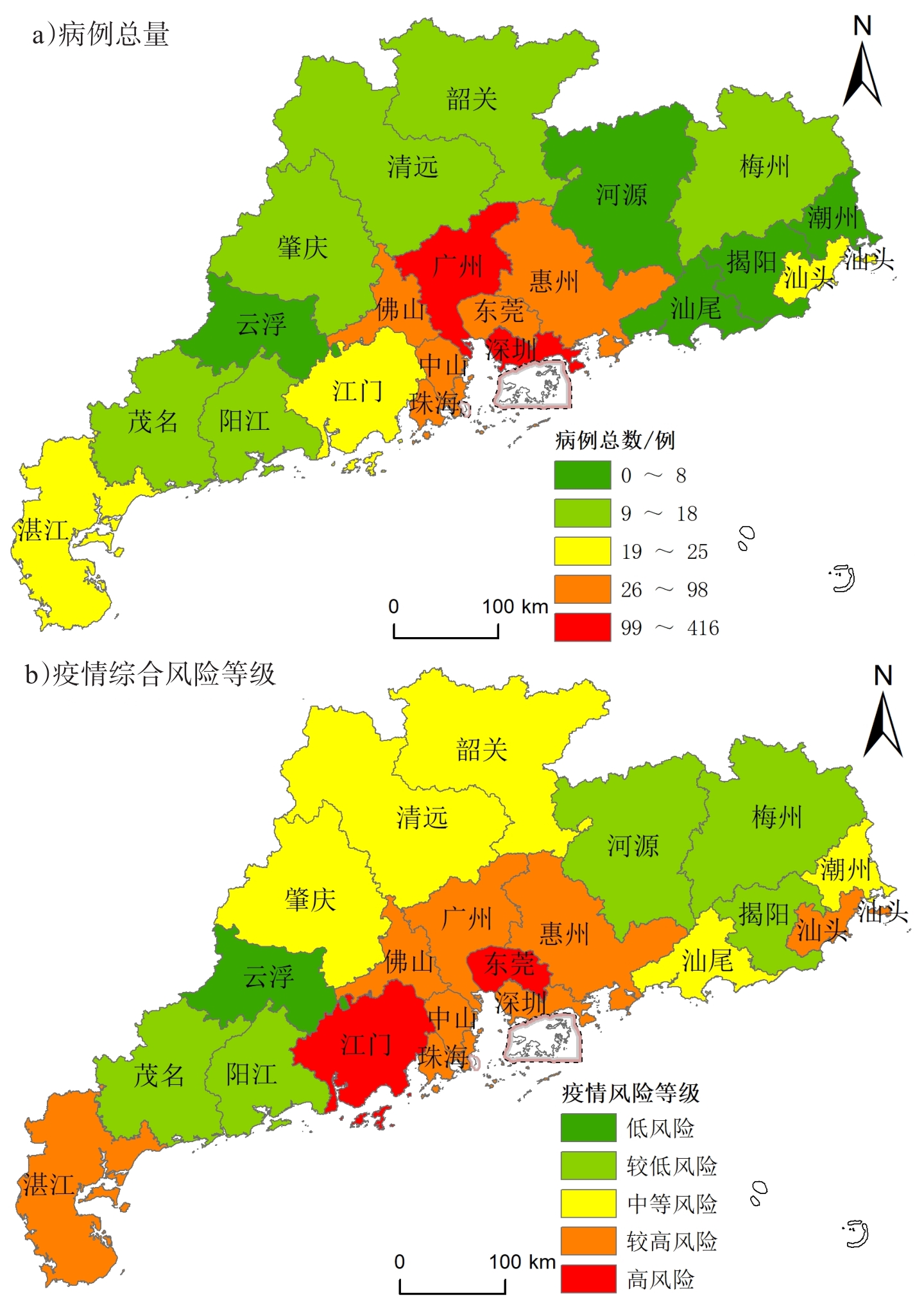
This report analyzes the spatiotemporal spread characteristics and the spatial variation of the coronavirus epidemic based on detailed information of confirmed COVID-19 cases released by the city health commissions in Guangdong Province. The report finds that: 1) the confirmed cases in Guangdong Province maintain certain age distribution characteristics. Middle-aged people represented the largest number of cases, followed by young people, and lastly, the elderly. These results are similar to national statistics; 2) the epidemic spread ratio in Guangdong is 0.198, which indicates that the anti-epidemic measures in Guangdong have effectively suppressed the spread of the epidemic; 3) the difference between the epidemic spread pattern and comprehensive risk pattern in Guangdong Province is significant. Medium-sized cities (third and fourth tier) have higher diffusion risk and medium comprehensive risk. Developed cities have lower diffusion risk but higher comprehensive risks, whereas undeveloped areas in eastern and western Guangdong are safer. Medium-sized cities are apparently weak areas that can be easily overlooked in anti-epidemic work; therefore the control of such areas should be strengthened; 4) the results of Guangdong's epidemic prevention measures can be actively promoted in the future to reduce public anxiety. The current priority should be the prevention of a second epidemic shock caused by returning workers and school students. In the middle-late stages of epidemic prevention, the implementation of risk management should be differentiated according to the epidemic risk levels among different cities for the sake of restoring social production and avoiding the negative impacts towards society stemming from the over use of anti-epidemic measures, especially for vulnerable and underdeveloped areas.
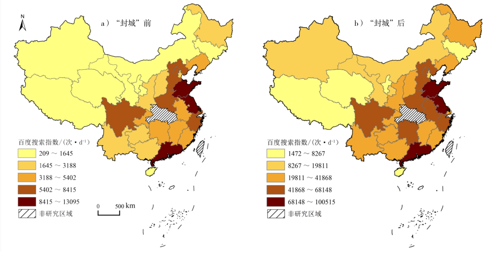
The rapid spatial spread of the Corona Virus Disease (COVID-19) in China during the Spring Festival has seriously endangered human health and garnered tremendous public attention via the Internet and social media. Although public attention plays a critical role in risk surveillance and epidemic prevention, there is a lack of comprehensive discussion related to its spatial-temporal differences and influence mechanism. This study focused on Internet public attention on COVID-19 using spatial analysis, spatial-temporal visualization, regression analysis of panel data, and other methods to investigate provincial spatial-temporal differences and possible influence factors of public attention in China from January 9 to March 2, 2020. In terms of data collection, the Baidu Index (BDI) was used as the measurement of public attention, disease-related data were recorded from the National Health Commission of PRC, and the population movement of Wuhan was based on geographic services of Baidu Qianxi. As per the findings 1) The spatial distribution pattern of public attention can be described as “large differences between east and west regions, higher in coastal areas than inland areas, and consistent with the areas of epidemic distribution.” In terms of temporal characteristics, there was a significant increase in the daily average of public attention in all provinces after the “Wuhan Lockdown,” and the same distribution pattern of overall levels of public attention was observed before and after the “Wuhan Lockdown.” Public attention reached its peak during the Spring festival and subsequently experienced a fluctuating decline with the periodic routine (incubation-outbreak) of the development of the epidemic. The themes of public attention moved from “searching information on related viruses in the early stage”, to “focusing on clinical diagnosis” and “the recent status of the development of the epidemic.” 2) Public attention is influenced by daily dynamic levels, including disease factor and population movement related to Wuhan, and economic/social development levels with fixed regional features. 3) Different phases of the issue—attention cycle receive different levels of attention. The effect of influence mechanisms on public attention before and after the virus outbreak is significantly different. Prior to the outbreak, information disease-related factors of confirmed cases and deaths could increase the public’s awareness and satisfy their fact exploration. After the outbreak, public attention was focused on population outflows from Wuhan. Compared to the first stage, the effect of regional factors on public attention increased after the outbreak, indicating that as the epidemic becomes gradually controlled, regional factor may have a sustainable and stable impact on public attention. 4) Media technology indirectly affects the public’s searching behavior during the epidemic. Higher amounts of available online information correspond to less searching behavior as the public becomes more informed. 5) The announcement of the “Wuhan Lockdown” did not cause a massive population movement as compared to the travel rush (Chunyun) during the Spring Festival. This indicates that the role of the incubation period may have had a negative impact of population movement on public attention before the epidemic outbreak, and that the media agenda and intervention from state authorities could arouse public attention on population outflow from Wuhan after the outbreak. Based on the findings, it is suggested that the government should focus on public searching volumes and enforce timely measures to surpass the speed of epidemic spread.
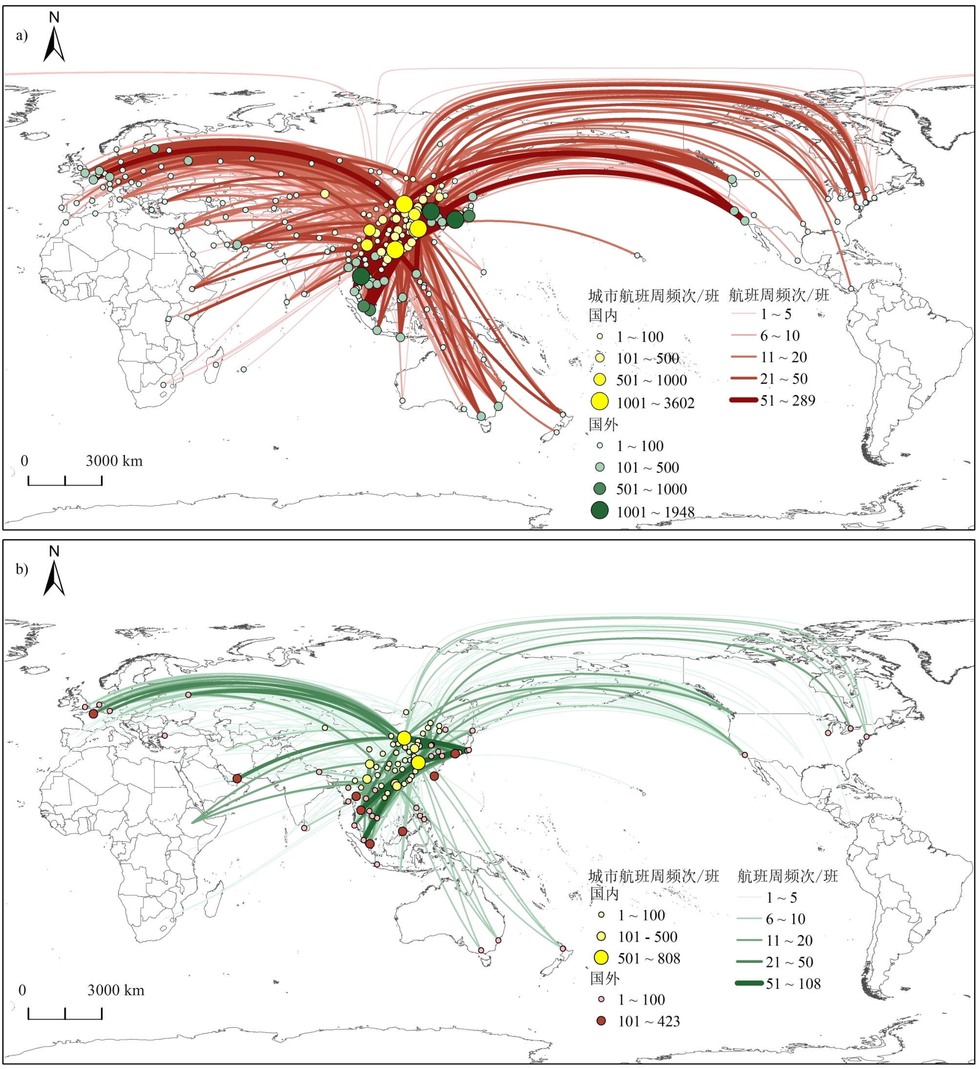
Air transportation plays an important role in connecting countries and promoting global economic development. Recently, China’s international air transport network expanded rapidly in terms of navigable countries and cities and the number of air routes and flights. In this context, the connectivity and stability of the air transportation network attracted significant attention, which could be threaten by many factors such as public health emergencies, poor weather conditions, policies, etc. Focusing on COVID-19, this paper depicted the spatial patterns of canceled flights after the spread of the COVID-19 pandemic across Chinese cities and the impact on connected countries and cities overseas. Next, this paper investigated the impacts of public health emergencies on the connectivity of China’s international air transportation network by comparing the changes of the average shortest path and weighted average shortest path before and after the outbreak of the COVID-19 pandemic. The results could be summarized as follows. First, the spread of this pandemic has significantly impacted the connectivity of China's international air transport networks. The number of navigable cities, routes and flights has substantially reduced, as has the efficiency of China's international air transportation. However, the COVID-19 pandemic has not significantly influenced the worldwide air transport network in this period. Additionally, the degree of effect of COVID-19 on air transportation connection was various across regions. For example, the air route suspension has the greatest impact on China's aviation network connectivity with Central Asia, West Asia and Oceania, while flight reduction has the greatest impact on China's aviation network connectivity with Northeast Asia, Central Asia and Southeast Asia. Second, there are no significant differences between the spatial patterns of the connectivity of China’s international air transportation network before and after the outbreak of the COVID-19 pandemic; the connectivity between China and Northeast Asia, Southeast Asia, North America, and Europe remains better than other areas. The findings indicate that labor mobility, economic communication, and trade are vital in shaping the spatial pattern of the connectivity of China’ international air transport network. However, the flight aggregation degree for international flights has increased. The proportion of flights among the top 5 countries has increased from 58.1% to 67.2%, which is also closely related to factors such as the proximity and necessity of personnel, economy, and trade links. The international route networks in Beijing, Shanghai and Guangzhou are more reliable than other cities. Thus, following the outbreak of COVID-19, the distribution of China’s international routes and flights has been concentrated in these major cities. The proportion of international air routes increased from 28.8% to 38.9%. Moreover, the concentration of international flights increased from 46.6% to 76.4%, which is a higher concentration than international air routes. While expanding its focus on the depth and breadth of international air transport links, China should focus on strengthening the reliability of international air transportation networks to cope with the impact of various emergencies and ensure basic connectivity and stable operation of international air transportation networks.
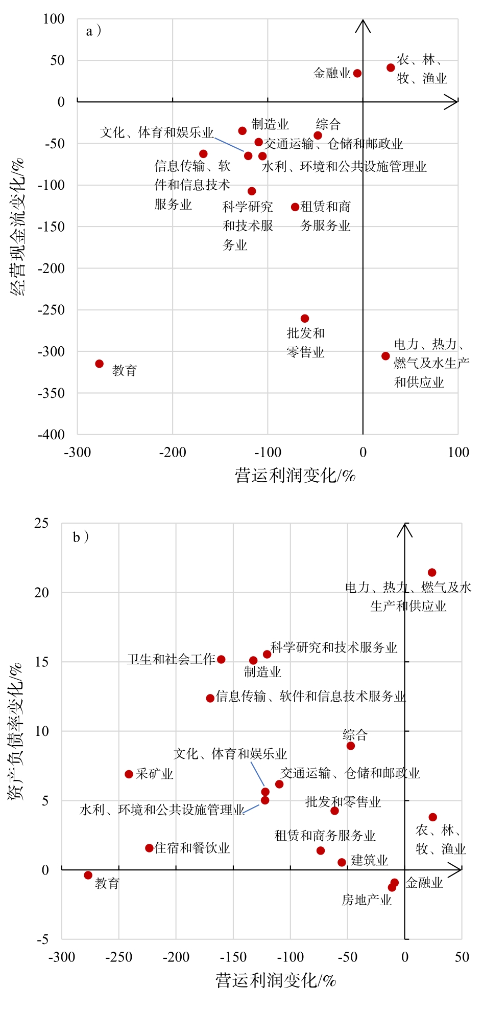
The Corona Virus Disease 2019 (COVID-19) has collapsed the world’s economy. A discussion of the reaction to structural and regional policies is imperative for the Chinese government because the implementation of policies is limited. As the state of the stock market indicates the direction of the economy, the financial reports of some enterprises from China’s Stock market for the first quarter of 2020 were collected and analyzed. This was the period in which the productivity of the enterprises were severely impacted by the coronavirus pandemic with respect to industry, actors’ scale, and region. The results show: 1) Except agriculture, forestry, animal husbandry, and fishery, all other industries had lesser profit and limited operating cash flow, and their balance sheets had deteriorated. The services industry faced more challenges than the others. The behavioral decisions made by individuals, the governmental policies for lock-down, and the nature of industries were responsible for these detrimental changes; 2) The companies with small and medium market value were affected more than big enterprises. In Q1, big companies made more profits, optimized their operating cash flows, and stabilized their balance sheets. This is mainly because of the difference of operating ability among actors and the Matthew effect; 3) Owing to the differences in the population structure and land price in different regions, the manufacture, service, and building and estate industries faced greater challenges in the developed provinces than in the less developed regions. The pandemic adversely affected the finance industry in Beijing, Shanghai, and Guangdong; however, it showed improvement in Jiangsu. It has been observed that the financial structure in regions, and operating ability of companies were the main reasons for the negative impact on the finance industry. The medical industry was affected but progressed in areas with better industrial basement. This was because the demand for certain medicines and devices peaked during the period and the areas with better industrial base played more important role in fighting the virus. In this context, the authors discussed the two approaches: “Adopting a more proactive fiscal policy and deeply optimizing financial environment of enterprises,” and “Choosing policies implements regionally.” It can be argued that unilateral expansion of demand will result in a larger gap between demand and supply. This is disadvantageous because the global production system mainly depends on the manufacturing industry in China. The government should not only focus on resumption, but also start investment of new or traditional infrastructures. Moreover, owing to the uncertainty of the market, the factors that improve the balance sheet are few. Therefore, helping more entities by financial market and making the social capital more active have become the priorities for the government. In order to improve the manufacturing and service industry, undeveloped regions are encouraged to expand job opportunities, and the residents in developed regions are encouraged to consume more services and decrease the operating costs of the service industry. This can positively contribute to restoring the economy. Some measures adopted to benefit financial and building and estate industries are encouraging local commercial banks in medium-sized and small cities to provide loans to Small and Medium-Sized Enterprises (SMEs), boost infrastructure construction in developed regions, and loosen control of estate development. The policy makers of the medical industry were advised to focus on long-term development. Optimizing the financial environments for SMEs in medical industry and developing a multi-core, nation-wide distribution of industry are necessary for China.
Population mobility affects the spread of the new coronavirus and of risk. Based on Baidu migration big data and provinces and municipalities’ health committee data, combined with geographic information technology, this paper studies the spatial relationship between the spread of Corona Virus Disease 2019(COVID-19) in 136 cities from January 1st to March 5th, 2020, and the outflow of population in Wuhan, which impacted urban public health management in China. The following results were obtained. The spread of COVID-19 in China has the following stages and characteristics: occurrence and recessive spread, rapid spread and outbreak, diffusion containment, and diffusion attenuation. From January 1st to March 5th, 2020, it was observed that the population flow of Wuhan City mainly extends to the Hubei Province and its surrounding provinces and cities, as well as Beijing, Shanghai, Guangzhou, Shenzhen and other first-tier cities, with geographical proximity and characteristics similar to regional central city population inflow. Influenced by geographical distance, time cost, social and economic connection, overseas input, and so on, the spatial distribution of COVID-19 is evidently unbalanced. The urban agglomeration in the middle reaches of the Yangtze River, the Beijing-Tianjin-Hebei urban agglomeration, the Yangtze River Delta urban agglomeration, Guangdong-Hong Kong-Macau Greater Bay Area, and the Chengdu-Chongqing urban agglomeration have become key areas for the concentrated distribution of COVID-19. Additionally, some key entry and exit port cities present a higher risk of spreading. A strong positive grade correlation between epidemic spread and population outflow is observed with COVID-19. The spatial relationship between the two can be divided into eight regulation types. Nearly 90% of cities have the characteristics of large population inflow, high numbers of confirmed cases or small population inflow, and low numbers of confirmed cases. Among these, cities with large population inflow and high numbers of confirmed cases are mainly concentrated in the Hubei Province and central cities of key urban agglomerations in China. The pressure of prevention and control stems from the risk of epidemic spread, caused by a large population inflow and high number of confirmed cases. The urban distribution, with a small population inflow and low number of confirmed cases, is scattered, and the difficulty involved in prevention and control is the improvement of the precision of such countermeasures. Although China’s strategies for epidemic prevention and control have achieved remarkable results, considering the evolution of the global epidemic situation, rebound uncertainty still exists, and external defense input as well as internal defense rebound pressure are still very heavy. Currently, and in the future, the prevention and control of the epidemic situation will become the “new normal” with the economic and social development of our country. Improving the capacity for urban public health management is necessary for the prevention and control of the epidemic situation in China, especially in the future. Chinese epidemic prevention and control should still consider local conditions and formulate targeted prevention and control strategies. In particular, it is necessary to consider the relationship between the spread of COVID-19 and population flow, economic ties, transportation costs, international exchanges and other factors, and set specific classifications and control plans. To facilitate the joint prevention and control strategy to formulate full coverage, and “Not One Less,” we should not only approach the current epidemic prevention and control it from a dynamic perspective, but also consider epidemic prevention and control work in specific types of cities. Urban agglomeration areas and port cities often have a large population inflow, frequent economic ties, high economic development pressure, and high-risk epidemic prevention and control. They bear the dual responsibility of economic and social development, stability, epidemic prevention, and control and management. In the context of resuming production, work, and economic and social recovery, special attention should be paid to the regular prevention and control of the epidemic situation as well as the improvement of urban public health management capacities.
On the eve of the 2020 Spring Festival, an epidemic of COVID-19 broke out in Wuhan and spread quickly across the country through population movements, posing a serious threat to Zhuhai and other large cities. In this paper, epidemiological survey data for 98 cases of COVID-19 published by the Zhuhai Municipal Health Bureau were used to analyze the spatio-temporal characteristics of 26 epidemic clusters, conduct case analyses of four types of typical transmission routes, and determine the spatio-temporal patterns and transmission routes of the virusin Zhuhai, with three main results. 1) The epidemic’s spread in Zhuhai was affected by timely population management and control in Wuhan, which restricted it to a limited range. 2) There were four different transmission paths: imported family cluster units, imported non-family cluster units, imported and local family cluster units, and imported and local non-family cluster units. The first unit was most important, though the path of non-family cluster transmission was especially complex; epidemiological investigations should be strengthened along with prevention and control measures. 3) For imported cases, given the lag time from importation to onset and the longest time interval between the onset of cluster units, a small number of cases or carriers can break the 14-day isolation limit currently in use, such that caution should be exercised regarding possible risks associated with this measure. Based on these, three recommendations can be made for the prevention and control of COVID-19. 1) It is necessary to fully estimate the risk of future epidemic spread that may be brought about by the movement of people returning to work following initial quarantine, while strengthening epidemiological studies, actively exploring the spatio-temporal law of population flow and epidemic spread, and using science-based methods to prevent and control further viral spread. 2) It is necessary to persist in the prevention and control of population movements from Hubei and other high-risk epidemic areas. The 14-days quarantine currently in place throughout the country is effective for the vast majority of cases or carriers of the virus, but the results show that a few can break this limit, suggesting that the isolation time should be prolonged by up to 24 days. 3) The combined use of epidemiological investigation and geographic information technology should be strengthened to improve the timely tracking of epidemic occurrence and spread, accurately identify the activities of high-risk groups, and conduct accurate and effective source tracing, prevention, and control. In short, for a major public health crisis like the COVID-19 outbreak, emergency management and control should involve many scientific fields (including medicine, geographic & information technology, computer science, psychology, and behavioral science) in order to achieve timely and effective prevention and control measures that rely on such multi-disciplinary joint action.
The sudden outbreak and spread of the Corona Virus Disease 2019 (COVID-19) has posed great challenges to the society as well as the academia of not only China but the whole world. The occurrence of epidemic has obvious time and space attributes. Analysis of the spatiotemporal diffusion pattern and process of the epidemic reflects the dynamics of the interaction between humans and the COVID-19, it is worth discussing from the perspective of geography, which is very important for measures for prevention and control of this public health emergency. Based on the confirmed COVID-19 cases’ details manually extracted from the official reports and the relevant Point Of Interest (POI) data, this study aims to reveal the spatiotemporal evolution and risk profiling of the COVID-19 epidemic in Shaanxi province. The results are as follows: Firstly, the age-gender structure of the confirmed cases was diamond-shaped, where more males than females are confirmed, and the overall age trended to be medium-old aged, especially the age group of 40-49. Both non-local and local infections were dominantly caused by the flows of people between cities. Most of the infections belonged to small clusters of core families due to imported cases from Wuhan City, while other large mixed cluster infections in special places may have a deep influence. Secondly, the epidemic evolution process can be roughly divided into three stages, namely wave development stage (Jan.23rd-Feb.6th, 2020), low-speed recession stage (Feb.7th-20th), and stable clearance stage (Feb.21st-Mar.15th). There were lag periods between the cases’ confirmed dates and the onset or initial diagnosis dates. Moreover, the initial reporting dates of confirmed populations were synchronized with the overall evolution of the epidemic. Thirdly, the spatial flow of the epidemic to Shaanxi province was different from that to other provinces around Hubei. That is, it had a unique spatial pattern of only a single cluster center. The overall spatial distribution of the epidemic presented an inverted T-type pattern concentrated in central and southern Shaanxi with significant spatial differentiation. The spatial evolution at the city level was three-pronged. Here, the Wuhan-Xi'an path was the most frequent flow path, exhibiting the flow pattern of "from one source to many sinks, and from Wuhan to central and southern Shaanxi". Finally, the high risk areas were these key cities, for example Xi'an, as shown by the "one big cluster with three small collections" pattern, with the risk level in urban areas being higher than that in the surrounding counties.
Malaria is an insect-borne infectious disease transmitted by anopheles. It was widespread in China about 3,000 years ago and continues to pose a severe threat to human life and health. Taking the Malaria epidemic during the Qing Dynasty as the research object, and using Excel, Geographic Information System (GIS), MaxEnt, and BounderSeer, the following results were obtained: 1) Malaria was one of the most common diseases during the Qing Dynasty. During fifty-nine of the total of 268 years of the Qing Dynasty, Malaria was widespread, with a frequency of 22.01%. The disease spread to 17 provinces, leading to an epidemic situation in a total of 210 counties, covering an area of 340,400 km2. This area accounted for approximately 2.69% of the total malaria-epidemic area during the Qing Dynasty. Malaria outbreaks frequently during the seasons of autumn and summer. These two seasons account for 85.23% of the total pandemic years and 92.47% of the pandemic-struck counties. Consequently, autumn and summer are targeted for the prevent and control of the Malaria pandemic. 2) Genetic adaptations to Malaria parasites is highly adaptable in China, with the southeast being the most optimal place for the mosquitoes to thrive. As per the distribution pattern, the risk of Malaria decreases from the southeast to northwest, of which, the Jiangsu, Anhui, Shandong, Henan, Hubei, and Hunan provinces have higher risks of Malaria. Various environmental factors affect the prevalence of Malaria with altitude, minimum temperature, and annual temperature difference as the main factors, with respective contribution rates of 44.4%, 16.3%, and 10.6%. 3) The geographical boundaries of Malaria were clearly established. The Malaria epidemic during the Qing Dynasty presented the boundary characteristics of "two horizontal and three vertical." The first horizontal boundary at the 40°N line and the second at the Nanling line were, respectively, the northern boundaries of Malaria and falciparum Malaria (pestilence). The first vertical boundary was an arc with Huoshan at its center. Using the straight-line distance between Huoshan and Hongya (approximately 1,250 km) as the radius, this area accounted for 96.67% of the Qing Dynasty Malaria pandemic. The second vertical boundary was the boundary line of the highly adaptable area of the Malarial mosquito, which included the eastern and central provinces of China. The third vertical boundary was the enclosure area based on the main Malaria network, covering the Yangtze River Delta region. However, the risk levels and boundary characteristics of the Malaria pandemic were not invariable and changed based on the natural and social environments. For example, the high-risk Malaria-endemic areas of the Qing Dynasty included Hubei and Hunan, with lower levels of risks in Sichuan, Yunnan, and other provinces, which still continue have low levels of risk. Investigating the temporal and spatial characteristics, risk levels, and boundary characteristics of the Malaria epidemic during the Qing Dynasty is expected to provide a historical basis for the improvement of the present Malaria control system, as well as a historical reference for dealing with sudden Malaria outbreaks.
Social mobility is transforming the way we survive , as well as our place of residence and production. Studies in mobility have evolved from a dispersive and independent mode to a multi-disciplinary form, led by geography and sociology , and have become a new multilevel interdisciplinary paradigm. Peter Adey’s Mobility (2nd Edition) is a classic textbook sorting out the evolutionary research path of mobility, interpreting its theories, and citing cases and methods from previous studies. This study summarizes main aspects of this book based on the background for the mobility research, its main contents, research methods, etc. Instead of dualism, future work could adopt networking and dialectical approaches to contemplate the world before conducting research on mobility. Additionally, future studies need to be grounded in a thorough understanding of the meaning, politics and practice of mobility, and related media. This study further suggests the conduction of future studies within the context of the politics of mobility, the spatiotemporal dimension of mobility, its relation to tourism, etc.
The relationship between protection of an outstanding universal value and regional development and utilization has always been an important aspect of World Heritage protection and management. As an important component of South China Karst, the Libo-Huanjiang karst World Heritage property was listed on the World Heritage list for its outstanding geomorphologic and aesthetic value, meaning that it should be protected by all the world. Its outcropped carbonate rocks developed in different geological ages and formed remarkable fengcong (cone karst) and fenglin (tower karst), which shows the change and evolution of landform between fengcong and fenglin. Guinan Railway, from Guiyang to Nanning in China, which will pass through the buffer zone of Libo-Huanjiang karst, is planning to be constructed for the display and community development of the world heritage property, as well as the poverty alleviation of the buffer zone (as peripheral coordination area of a world heritage property to reduce the adverse effects caused by human activities outside the area). The area of the property and its buffer zone are 366.47 km2 and 479.28 km2, respectively. This study used 3S technology and field studies to assess the impact of Guinan Railway construction on the hydrology, geology, and landforms of the area with regard to its geomorphologic value and the potential effects of the buffer zone. The results indicated that: 1) Carbonate rocks are continuously distributed throughout the property and its buffer zone; karst systems are obvious and support many springs. Underground rivers are mainly distributed in fengcong-valley, fenglin-valley, and depression landscapes. The area’s special hydrogeological conditions are represented by typical geomorphological types such as fengcong karst and fenglin karst as well as active groundwater features. 2) The Guinan Railway will pass through the buffer zone of the property, though not through the property itself, so will not directly influence its geomorphological value. The Chaoyang Tunnel will be located within the upper reach of the buffer zone, and the its capture rate of the Di’e River during construction is expected to be 0.88%. Although this is predicted to have little effect on groundwater flow diversion from the Di’e River, monitoring and management of the Chaoyang Tunnel will be indispensable. 3) The railway route is designed to cross the buffer zone via bridges, tunnels, and subgrades. All the bridges are designed to cross rivers without support piers, avoiding impacts to water quality and quantity. The Jiuwandashan No.2 Tunnel may reduce the groundwater level within its cone of depression, but would have little influence on the property’s hydrogeological conditions and karst processes. The exposed subgrades will cross non-karst landforms, having no effect on karst landforms within the property. 4) The hydrogeological units of the Da-xiaoqikong and Maolan-Huanjiang components, the two parts of Libo-Huanjiang karst, are different, with no unified groundwater hydraulic connection, so the Guinan Railway would not affect groundwater hydraulic connections and karst processes. 5) The railway route would affect 13 fengcong-depression sites with an area of 5.32 km2, accounting for 1.22% of the total area of the buffer zone. Therefore, it would have little influence on the zone’s buffering effect.6) The existence of the buffer zone protects the geomorphologic value of the property from potential impacts of Guinan Railway construction, as a buffer zone is meant to do. However, due to unique connections between changes in karst water environments and karst landform evolution, further research on the hydrogeological processes at karst-related natural World Heritage sites and the evolution of karst landforms is still needed. In addition, the monitoring and management of railway projects during the construction and operation periods should be strengthened.
Landslides are the fourth leading natural hazard that threaten human survival after floods, earthquakes, and drought. The frequency and density of landslides are increasing with the intensification of climate change and human activities. For World Heritage Sites around the world, landslide risk affects their integrity, aesthetic value, and sustainable development. The study of the spatial and temporal distribution patterns of landslides could aid in understanding the factors influencing landslide and provide guidance for disaster prevention and mitigation and heritage conservation. The Honghe Hani Rice Terraces World Heritage is an important cultural landscape located in the mountainous area of Yunnan Province, China, where landslides frequently occur during the annual rainy season. To investigate the spatiotemporal pattern of landslides in the heritage core area, a landslide database was established based on the remote sensing images of Google Earth at a resolution of 0.55 m in 2005, 2009, and 2015, combined with a field survey. The nearest neighbor index, K function, and kernel density function of the landslides are calculated and analyzed with ArcGIS 10.2. The results are as follows: 1) The number of landslides of study area in 2005, 2009, and 2015 are 184, 337, and 285 respectively. The nearest neighbor index indicates that the landslides are spatially clustered, and their aggregation decreased over time. The K-function analysis shows that the most significant spatial scale of landslide aggregation is 1 km. The thresholds from aggregation to discrete distribution are 2.9, 3.9, and 3.6 km in 2005, 2009, and 2015, respectively. 2) In terms of spatial distribution, the analysis of the kernel density function shows that the high-density area of the landslides in the heritage core area contains multiple centers, such as forest areas on the western and eastern sides of the study area; the villages of Duoyishu, Dongpu, Mengpin, and Shuibulong; and terraced fields in the Amengkong and Bimeng river basins. 3) During the period studied, the proportion of high-density landslide areas increased from 2005 to 2015 (2.3%→5.8%→8.3%). The proportion of medium-density areas also increased (15.7%→21.8%→27.9%), while the proportion of low-density areas decreased (82.0%→72.5%→66.8%). On the scale of administrative villages, the proportion of high, medium, and low-density landslides in each village varied over time. The villages with increased high-density areas over time are Dongpu, Shuibulong, Duoyishu, Baoshan, and Xinjie, which need to reduce landslide risks significantly. The detailed analysis of the occurrence mechanism, influencing factors, monitoring, and early warning of landslides is beyond the scope of the present study. In the future, we will explore the potential interactions between geographical conditions and landslides. In particular, we will quantify the contribution of human activities to landslide risks to improve our understanding of the mechanisms of landslide occurrence in similar regions as well as the accuracy of landslide risk prediction. In summary, the spatial pattern of landslides in the study area changed significantly from 2005 to 2015. The risk of landslides has become more unpredictable as human interventions increase on the surface landscapes.
The rapid increase in the overweight rate among Chinese residents is accompanied by a complex overweight differentiation characteristic. However, little is known about the causes of the differentiation at a community level. Thirty years of housing system reform has led to China's housing pattern evolving into a variety of types. It will be of theoretical and practical value to study the mechanism of the influence of residential type on the rate of residents’ overweight under the specific policy and social background of China. Based on 962 questionnaires from 25 typical communities in Guangzhou (categorized into four residential types), we used chi-square analysis and a binary logistic regression model to analyze the residents’ overweight differentiation characteristic and its mechanism on a community level. The results showed that the overweight rate of residents and its differentiation characteristic varied between residential types. Demographic features and community environment were the core variables that explain the above-mentioned differentiation by residential type. 1) The incidence of overweight in the order of highest to lowest was as follows: historical district, indemnificatory housing, unit community, and commercial housing community. Commercial housing communities attract young people with high education, high income, a generally better health awareness and community resources availability leading to the lowest overweight rate. Due to long-term housing isolation, poor marketability and earlier construction, unit communities and historical districts drew residents with low education and income, in addition to which historical districts had a large proportion of the elderly. Consequently, both residential types had a higher overweight rate. Indemnificatory housing tended to support low-income groups, and usually had a poor community environment so although residents had a higher education level, there was less opportunity to use physical activity resources, therefore this residential type had a higher overweight rate. 2) Age and marital status were important influencing factors of overweight for all residential types which indicates that this is of concern for both the elderly and married population. With regard to other aspects of demographic and socioeconomic attributes, as well as leisure-time physical activity levels, overweight differentiation among the residential types had varied characteristics and mechanisms. An increase in income provided individuals with more access to social resources including physical activity facilities and food facilities, resulting in an overweight differentiation for both indemnificatory housing and unit communities. Moreover, in respect of indemnificatory housing, non-agricultural residents from other cities had higher income levels than other hukou types, so they tended toward higher physical activity and diet resource acquisition ability or a higher intensity physical activity (physical work) which reduced the overweight level. Education levels affected the leisure-time physical activities and other health behaviors of people in historical districts, leading to an overweight differentiation. Commercial housing communities consisted of higher income residents whose unhealthy work practices contributed to an overweight differentiation at the community level. This study revealed the characteristics and mechanism of overweight differentiation in Chinese residential patterns and proposes a number of community optimization measures to alleviate overweight, which may help improve the health of residents living in these communities and promote the implementation of the “healthy China” strategy. Further research might be needed to establish the mechanism of overweight differentiation in terms of gender and leisure-time physical activity.
Along with environmental problems that constantly emerge due to rapid industrialization and urbanization, human settlement, an ancient and new field in the man-land relationship research, is attracting increasingly wider attention in academia. Taking the China National Knowledge Internet (CNKI) and Chinese Science Citation Database (CSCD) as the literature search engines, and based on the platform of CiteSpace, this paper analyzes and summarizes the general characteristics and the mapping knowledge domain of human settlement research from 1992 to 2017 in China. The results show the following: 1) There has been a significant increase in the number of published articles on Chinese human settlements, and the Architectural Journal, City Planning Review, and Urban Development Studies are the main journals for publication. 2) The most competitive research institutions and teams are mainly found in the Institute of Geographic Sciences and Natural Resources Research, Chinese Academy of Sciences (CAS), as well as in other architectural & planning and normal universities, such as Liaoning Normal University, Tsinghua University and others. 3) As for the funding sources, there is an obvious diversification trend with national funding being the primary source of research grants. 4) In terms of key research areas, human settlement, residential environment, livable city, human environment, sustainable development, living space, and the like have been focused on for a long time. 5) In terms of the research topics and intellectual base, the research content on human settlement is relatively broad, and there is no focus on any specific topic. Based on 31 classic articles, "Urban human settlements”, “livable city”, “rural human settlements”, “residential environment”, “nature suitability”, “residential satisfaction”, “sciences of human settlement”, and “population development” are 8 hot topics. 6) As for the evolution route, the development of research on human settlements in China has shown a clear evolutionary process and has a strong problem orientation and policy research orientation. Stages and dynamics of socio-economic development, as well as problem and policy orientations of research are the main driving forces for its evolution. In addition, the cooperation and exchange among scholars, interdisciplinary integration, and the innovation and application of new technology and methods can also promote its evolution. Throughout the history of Chinese human environment research, scholars have always focused on the nation's requirements, focusing on the two central elements (i.e. human and environment) of human settlements and their relationship. However, the understanding of related studies of theoretical cognition, research object and content, and research scale and method should also be further deepened and expanded. This paper clarifies the context of the development of the science of human settlements in terms of time, deepens the understanding and grasp of the human settlement research, as well as provides scientific reference for subsequent research.
This study examined the spatial diffusion of golf courses in mainland China from 1984 to 2016 through the application of spatial analysis and mathematical statistics. We found that since the early 1990s, the central government has introduced policies to limit course expansion. However, it was not until 2014 that the rapid national expansion of course construction was brought under control. Overall, the number of courses experienced a low-rate expansion period in 1984—1994, a steady expansion period in 1995—2004, an accelerated expansion period in 2005—2013, and a contraction period in 2014—2016. The spatial distribution of courses has also experienced expansion and contraction periods, with the most significant spreading occurring northward and westward. Golf courses are clearly clustered in China. The Yangtze River Delta, Pearl River Delta, Bohai Rim region, and capital cities in central and western China that feature relatively high levels of economic development, more outward-looking economies, and dense populations have larger numbers of courses, indicating that the spatial distribution of golf courses in China is affected by socioeconomic factors. Correlation analysis further showed that socioeconomic factors such as per capita GDP, population size, regional openness, and transportation dominance are significantly positively related to the spatial distribution of courses, with transportation dominance having the greatest impact. There were 115 golf courses in six transport hub cities, accounting for 25.96% of the total. It is worth noting that despite the scarcity of land resources in China, local governments are interested in building courses to develop tourism and leisure industries and attract foreign investment. There is also a significant positive relationship between the scarcity of land resources and the spatial distribution of courses. The spatial diffusion model of courses was characterized by a degree of regularity. Specifically, courses first appeared in the coastal areas with developed economies and a high degree of openness to the outside world, and then spread to surrounding and inland areas, demonstrating obvious contact diffusion characteristics. In addition, metropolitan areas first built courses, and then surrounding lower-level cities also built courses in Bohai Rim and the Yangtze River Delta regions. The spatial state model further confirms that golf courses in China present obvious contact and hierarchical diffusion characteristics. This study’s findings promote a better understanding of the spatial diffusion patterns of golf courses in China since the reform and opening up and further enrich the theoretical study of the spatial diffusion of sports culture in Chinese human geography.
The economic and social transformation and reconstruction in China has prompted the government to focus its attention on the role and influence of vocational education on the development of the manufacturing industry and improvement of social equity. Secondary vocational education is an important part of popularizing high school education and developing modern vocational education in China. It is the foundation of constructing a modern vocational education system. It is of great significance for the cultivation of middle-level skilled technical talents and the improvement of the labor market. Based on statistical data of the development of secondary vocational education in 31 provinces and regions in mainland China from 2000 to 2016, this study focuses on the spatial clustering characteristics and factors influencing the development of secondary vocational education. The study adopts methods such as geographical concentration, spatial autocorrelation analysis, geographical detector, etc., to explore the following issues: How will China’s secondary vocational education change in a spatiotemporal context? Is there spatial agglomeration? What are the factors that cause the spatial agglomeration of secondary vocational education? This study shows that the development of secondary vocational education in China followed an inverted "U" trend from 2000 to 2016, and the geographical concentration of students in the provincial level is gradually increasing. The provinces with large-scale secondary vocational education include Guangdong Province, Henan Province, and Shandong Province. The development of secondary vocational education in more than one-third of the provinces in China is characterized by small scale and slow growth, as seen in Beijing, Tianjin, Shanghai, Fujian, Hubei, Shaanxi, Shanxi and Northeast China, while the "growth" provinces are all distributed in southern China, including Anhui, Jiangxi, Hunan, Guangdong, Guangxi, Yunnan, Guizhou, Sichuan, etc. From the perspective of spatial relationship, there is a significant spatial autocorrelation between the level and growth of secondary vocational education from 2000 to 2016, but the degree of spatial agglomeration has declined; this indicates that the spatial balance of secondary vocational education is constantly improving. In addition, the overall level of secondary vocational education shows a trend of "moving south." The hotspots have moved from North China to Southeast, Central, and South China. Shandong, Henan, and Anhui provinces are always included as hotspots of secondary vocational education. The hotspots of secondary vocational education growth are mainly distributed in the western region, and show a transfer process from northwest to southwest. Tibet is always in a hotspot of growth. The main factors influencing this pattern of change are the population of school-age children and secondary vocational education development conditions, while the role of regional economic development level is relatively small. The interaction between different factors significantly affects the changes in the spatial pattern of secondary vocational education, mainly through interactions between the number of junior high school graduates and other factors.
Based on a variety of Spatial Analysis techniques, this study examines the museums in Shanghai and discusses their time-space characteristics and the influences of space-time evolution mechanisms on them. The results show that the development of the said museums can be divided into three phases: exploration development (1978-1985), steady development (1986-1997), and high-speed development (1998-2016); and that the internal types of museums considerably differ from one another. Museums were also found to be primarily concentrated in the central city and along the Huangpu River, showing a typical “core-edge” diffusion feature. Additionally, their spatial distribution in the central city area followed a complex fractal structure radial trend and their development can be described as being gradually rich and diverse. At the same time, the spatiotemporal evolution of museums was discovered to result from the interactions between multiple factors: 1) The regional difference in historical and cultural resources, the most important factor affecting the development of Shanghai’s museums frames the basic pattern and main types of museum spatial distribution and limits the evolutionary trend of the aforementioned development. 2) The strategic orientation of government policies is also a key factor leading to the phased development and changes in these museums. This overall guidance and regulations gradually gave them a logical layout. 3) The financial support for regional development is a prerequisite to ensure the continuous improvement of the museums. 4) Spatial differentiation of regional population is an important influencing factor that causes differences in the museums’ spatiotemporal patterns. 5) And traffic access is the primary location condition that determines the spatiotemporal evolution trend of museums. These have all further strengthened the uneven distribution of museums. As a result, this article arrived at the following findings In terms of the process of benchmarking the construction of an “excellent global city” at a development level, Shanghai should work on further improving the indicators of the museum’s public service, cultural, and creative product revenue. It should insist on building museums to contribute to the cause of cultural preservation and growth as well as optimize its museum business model at the levels of incremental expansion and rational planning. With respect to quantity, it should actively explore museum resources and encourage the participation and investment of nongovernmental forces in museums. In terms of spatial layout, it should consider the balance of the geographical distribution in the various types of museums, break through the unipolar development model that focuses on the central urban area, specifically strengthen the construction of museums in the suburbs, and fully tap surrounding historical and cultural resources. In addition, it must promote the proper allocation of public cultural resources and the localization of its urban culture, thereby fostering the balanced development of museum spatial distribution.
At present, along with rapid urban-rural transformation, rural development faces a new round of challenges. Under the progressive drive of urban-rural integration development, new countryside construction, and the rural revitalization strategy, rural development has been gradually receiving attention. Since 2013, many nationwide rural construction practice explorations have been carried out. Among them, local practices represented by beautiful village construction have achieved staged results. In this context, based on four batches of 160 village construction pilots published by Guangzhou from 2013 to 2016, the research attempts to explore spatial differentiation characteristics of the beautiful village in Guangzhou and its influencing factors using GIS spatial analysis methods such as the nearest neighbor index, multi-distance spatial clustering analysis based on Ripley’s function, kernel density analysis, and overlay analysis. Based on a geospatial perspective, this study attempts to provide a phased assessment of the current spatial distribution of beautiful village, to expand the spatial dimension of this kind of village and “village cluster” study. First, since 2013, the number of beautiful village in Guangzhou has increased year by year and the growth rate is on the rise. At the same time, their spatial distribution presents obvious concentrated characteristics. Nuclear density analysis shows that high-density areas of these villages are mainly distributed in the south and northwest of Guangzhou, including one hotspot main core area of Panyu-Nansha and two hotspots sub-core areas of Conghua and Huadu-Baiyun. The density distribution shows a multi-core imbalance. Second, the main factors affecting the spatial distribution of these villages include topography, hydrology, human population, history, transportation, location, policy, and planning. Among them, topography and hydrology constitute the basic motivation for rural development; deep historical and cultural resources are the spiritual driving force to support the continuous development of rural areas; transportation and location are a key positive factors affecting rural development; policy and planning factors have a decisive influence on the "beautiful village cluster" spatial pattern, which is manifested in government efforts to promote the concentration of village space through the formulation of selection criteria, post-construction evaluation and acceptance mechanisms, construction action plans, and "beautiful village cluster" planning. Guangzhou beautiful village planning and construction has achieved initial results and gradually formed “beautiful village clusters” based on the hotspot core areas. This kind of government-led village pilot construction has promoted village spatial concentration but has exacerbated uneven development among villages. Therefore, under the strategy of rural revitalization, we should strengthen the diversity and locality of the selection of village pilots, push forward the transformation of "village cluster" from spatial concentration to industrial agglomeration, pay attention to the pluralistic value of these villages, and explore new models of governance led by communities, to explore new directions for rural development.
Dike-ponds are a type of ecological agricultural land formed by man-made depressions in ponds where silt is accumulated as dikes to farm fish and grow crops such as mulberry and sugarcane; they are mainly distributed in the Pearl River Delta. Ecosystem services refer to the living environment they provide for human beings, as well as the various types of ecosystem products and functions that are beneficial to human beings. In recent years, Ecosystem Service Value (ESV) has become a hot topic for scholars in China and abroad. Using the Pearl River Delta’s birthplace, Foshan City (FS), as a case study, the Millennium Ecosystem Assessment (MA) framework, which combines the characteristics of a dike-pond ecosystem and the social and economic conditions of the study area, is used to adopt the market price method, replacement cost method, and shadow engineering method to estimate the ESV of dike-ponds in FS in 2000, 2009, and 2017. Additionally, Dike-pond’s ESV in FS law of change was discussed and the influencing factors of ESV changes in dike-ponds were analyzed. The results show that during the study period of 2000-2017: 1) a few towns (streets) such as Lubao Town and Hecheng Street in the west and north, respectively, of FS have increased their dike-pond area, while Beijiao Town and Lecong Town in the east and south, respectively, have significantly decreased their dike-pond area to 19,244.47 hm2, which have been mainly transferred to construction land. 2) In 2000, 2009, and 2017, the ESV of dike-ponds in FS first decreased and then increased to 1,661.91×108 and 978.60×10⁸, and 1,166.37×108 yuan, respectively. The overall trend is a declining one, with a total decrease of 495.54×10⁸ yuan. In the three years, the proportion of adjustment functions in the total ESV is higher than 86%, which is the core function. Among the individual functions, the value of tourism and leisure increases the most, with an average annual growth rate of 19.36%. The value of climate regulation decreases significantly, by 589.37×10⁸ yuan. 3) The ESV of dike-ponds in the southeast of FS is the highest. The western and northern regions are less affected by human activities and the ecological environment is suitable in this region; thus, the ESV of the dike-ponds increases accordingly. While the high level of industrialization and urbanization in the eastern and southern regions, serious pollution in the dike-ponds, and shrinkage of the dike-ponds all caused the ESV to decline, the material production and tourism and leisure values of the dike-pond of each research unit generally increased. The value changes of the remaining individual functions show strong consistency in space, i.e., the value of the towns (streets) in the northwest and southwest has increased significantly and the value in the southeast has decreased. 4) The results of a Geodetector probe show that a change in the Gross Domestic Product (GDP) of primary industries is the principal factor affecting the spatial distribution of the ESV of dike-ponds in FS, followed by the change in GDP, population density, population, investment in fixed assets, GDP of the secondary industries as well, and impact of policy factors, none of which should be ignored. Measures such as controlling the scale of development, restoring green vegetation, and giving importance to the advantages of the dike-pond landscape to increase the ESV of the dike-pond are all recommended.