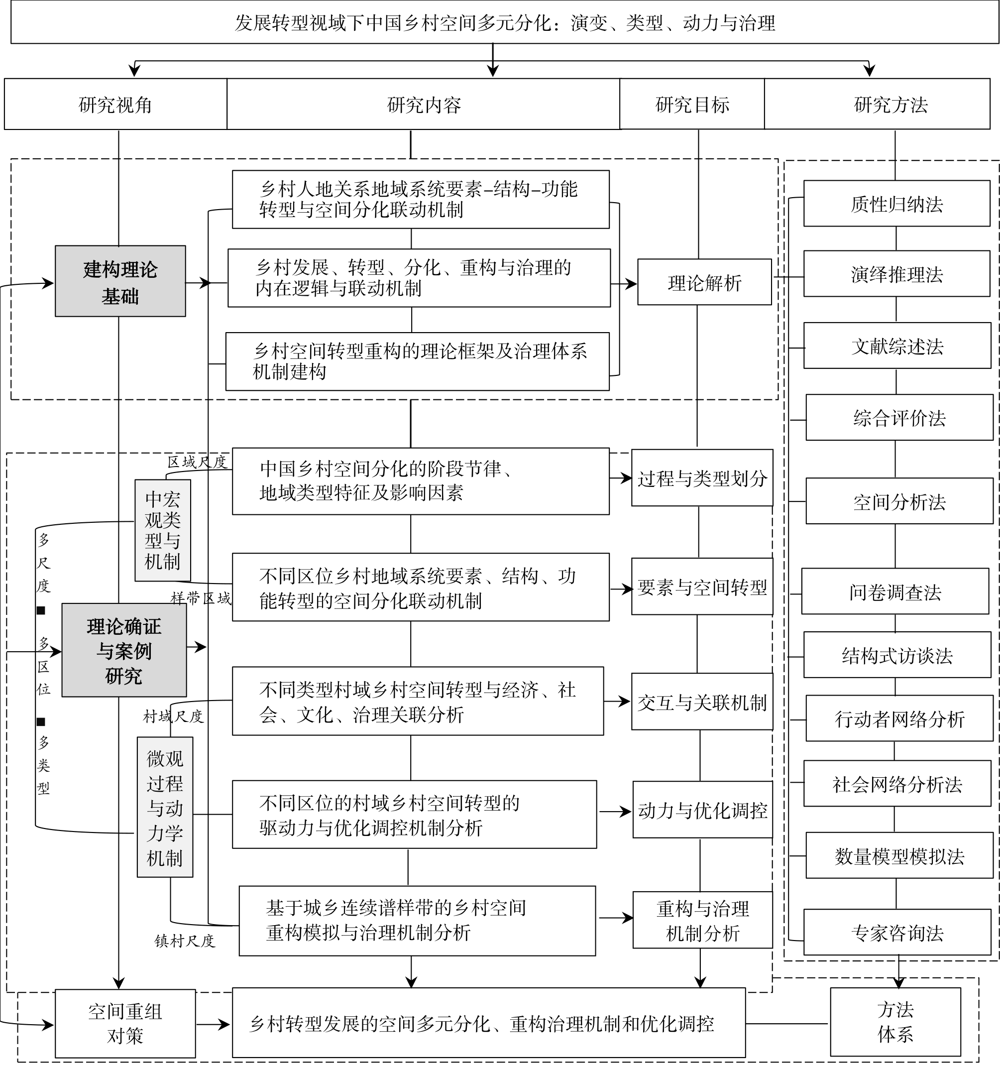
With industrialization, urbanization, informatization, and economic globalization, there is significant diversification in rural areas, including the social and economic devolopment and rural landscape, land-use structure, urban—rural relationship, consumption structure, and governance pattern. Development and evolution are types of spatial transformation, and their differentiation is significant in rural areas. With changes in the relationship between human beings and the environment in rural areas, problems such as the gradual disappearance of traditional villages, loss of regional identity, precariousness of villagers’ development prospects, and loss of autonomy tend to arise. The renaissance and revitalization of rural areas have become the core target of regional and rural development in this new era. Development, together with the theoretical construction of rural geography, now faces a critical period of opportunity. The mechanism of interaction between the internal and external motivations of rural spatial differentiation needs to be clarified, and geographic parameters concerning the reconstruction of rural multidimensional space need to be examined carefully, as they take a scientific approach in exploring comprehensive rural governance. These are beneficial in strengthening both rural construction and the framework of governance theory. This paper systematically reviews the progress of research on rural spatial differentiation, reconstruction, and governance both at home and abroad. We found that, internationally, research on rural geography is more diverse, and theories and methods from the field of political economics and sociology are widely used. These research methods are mainly qualitative, focusing on the theoretical interpretation of the construction and translation of the actor-network of cognition, differentiation, and reconstruction of rural space. Further, the main body and framework of rural community governance are analyzed deeply. Domestic research, in contrast, focuses on the differentiation and reorganization of rural material space, but the content framework and methodology of rural spatial differentiation, reconstruction, and governance remain insufficient. Accordingly, this paper—guided by the theory of territorial system of human—environment interaction on a macro scale—systematically examines the spatial differentiation types and dynamic mechanism of rural development and transformation under multiple external environments in China. On a medium-micro scale, the comprehensive study of the rural human—environment relationship in a regional system is implemented, focusing on element structure, function change, element reconstruction, and space governance. We performed a space gradient analysis using urban—rural continuous spectrum geographic transects, which analyzed internal multidimensional space differentiation and reconstructed the scientific logic of governance in different locations and with different types of rural space. By integrating geography, sociology, politics, management, and other subjects, we constructed a unique theory framework for the transformation of rural space in China. Rural space governance is an important part of territorial space control and social governance, and is of interest across multiple academic disciplines. The collaborative mechanism between the governance of space and the participating community, as well as the approaches and models of village construction management and spatial governance used, needs an urgent conclusion and summary.
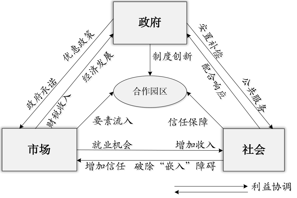
As a means of inter-regional resource complementarity and win-win cooperation, cooperation zones play an important role in promoting coordinated regional development, narrowing regional gap, enhancing the regional whole competitiveness, and achieving high-quality regional integration. Cooperation zones are a significant topic in trans-regional cooperation research. Correlational research employs the enclave economy theory, the space production and space restructuring theories, the social capital theory, growth alliance, and the cross-border region theory to explore the type, cooperation impetus, and effects of cooperation zones through the lens of collaborative agents, management systems, spatial governance, and benefit sharing. This research adopts the relevant theories of geography to promote innovative research in cooperation zones. The research methods for the classification of cooperation zones mainly include stakeholder, organizational behavior, and empirical case comparison analyses. The diverse types of cooperation zones form a hierarchical classification system, according to the main body of participation, the form of cooperative governance, and the industrial functions of a park. The cooperation impetus includes government-driven, market-driven, social-driven, and benefit sharing driven, and the driving forces interact. The combination of government and market factors is the key driving force for cooperation. The driving force of government gradually gives way to market-driven forces. Common interests are the core element of cooperation, and benefit sharing is the prime power for the development of cooperation zones. Benefit coordination is the key to their sustainable development, while benefit compensation mechanisms among cooperating subjects constantly innovate. The cooperation effect is various and comprehensive. By fostering regional economic growth poles, cooperation zones can promote regional economic growth and speed up the free flow of elements and industrial transfer between regions. This, in turn, promotes industrial layout optimization, transformation, and upgrading. In addition, the cooperation effect also manifests in narrowing the gap in regional economic development, promoting regional coordinated development, accelerating urbanization progress, strengthening inter-regional economic cooperation, and improving regional comprehensive competitiveness. However, problems persist. The classification criteria of some types are not unified; the quantitative research and coupling relationship studies on cooperation motivation are insufficient; the research on cooperation effect lags behind and lacks scientific and objective systematic evaluation systems. Therefore, this paper makes a prospect of innovative research on cooperation zones that can focus on three aspects. 1) Few studies have covered the types, dynamics, and effects of cooperation. The systematic and comprehensive study of cooperation zones should be further strengthened and innovated. 2) Regional cooperative governance’s reflection in cooperation zones has been preliminarily discussed; however, in-depth theoretical research on the driving mechanism of trans-regional cooperation governance must be further explored. 3) Current research focuses on the development of cooperation zones. At the macro level, cooperation zone research can also be extended to the evaluation of regional integration policies. Future in-depth theoretical and empirical studies on evaluating regional integration policies should be carried out based on the case of cooperation zones.
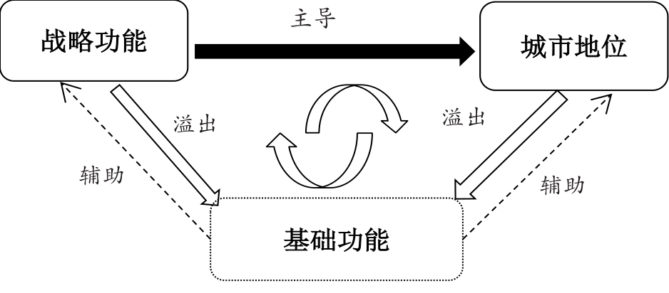
Since the beginning of the 21st century, informationization and globalization have greatly impacted the development of cities. This was not the rapid growth of all cities within the national urban system, but the development of certain key cities linked to the process of globalization. In other words, the functions undertaken by cities determined their future development potential and status. The topic of “first-tier cities” is presently being debated in all sectors of society. Several media and research institutions have been racing to release series of rankings such as “new first-tier cities” and “quasi-first-tier cities,” in an attempt to continually re-rank the major cities in China. Behind such public opinion is a comprehensive consideration of the functions of a city, with an empirical understanding of its development potential and status. However, although different evaluation indexes directly affect the score of a city, there is currently no set or recognized system by which to conduct the evaluation of a city. This study explores the mechanism that influences urban status via a “theory to empirical” approach. By sorting the research on cities globally, this study extracted the internal logic by which urban functions drive the change in the status of big cities and constructed a role model for “strategic function–basic function-city status.” This study suggests that the functions of international cities can be classified as strategic and basic, of which the former is the fundamental force driving the status changes of big cities. Big cities play the role of a control center in national economies and regional layouts and can create a regional influence in areas including economic, financial, political, trade, information, and scientific innovation functions. The basic function of such a city is an important external manifestation of its strategic function and guarantee of the maintenance and betterment thereof. Big cities play the role of a hub and node, that can provide highly modernized infrastructure and international service functions that will simultaneously and indirectly impact the effect of their strategic functions and the transformation of their status. Using this logical framework, this study demonstrates the path by which the urban status of Hangzhou is being upgraded, identifies the functioning of a digital economy as the strategic function of this city, confirms the rapid development of the former and the promotion of the urban status of the latter, and responds to public opinion that Hangzhou is now a “first-tier city.” By introducing the concept and characteristics of strategic functions, this study highlights and emphasizes the importance for the rapid development and status upgradation of big cities in China. The development of such cities need to judge other cities worldwide, based on their own advantages. With a leading edge such cities can join the globalized system, conform to the scientific and strategic function of global development trends in a reasonable way, and stand out from others. Furthermore, with new “city business card”, such cities can enter the fast lane of benign development.
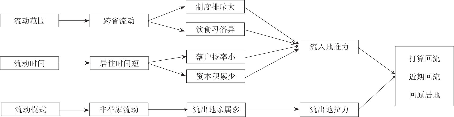
Drawing on data from the 2016 "Migrants' Dynamic Monitoring Survey", using descriptive analysis and three multinomial logistic regression models, this paper describes the latest status and characteristics of return migration intentions, and explores the relationship between migration characteristics and return migration intentions. Findings showed that migrants’ return intentions is particularly weak; more than 40% of migrants plan to return in the near future; the return regions are diverse and dispersed. They present a multi-location interactive mode of "destination place, namely the original location as the main part and administrative townships and counties (districts) as the auxiliary part." Among the migrants who return to their administrative townships and counties (districts), the proportion of those who return to their administrative county is higher than that those who return to their administrative township. The results of the models show that migration characteristics have a significant influence on return migration intentions. Intra-provincial migrants are more likely to return than inter-provincial migrants. Compared with migrants with shorter migration times, migrants with longer migration times are more likely to return; to do so within 2 years; and return to their point of origin. Migrants within the category of non-whole family migration are more likely to return; to do so within 2 years; and return to their point of origin than in the case of whole-family migration. Compared with migrants who have no children left behind, migrants who have left children behind are more likely to return and to do so within 2 years than those who have not. Migrants' return intentions is obviously influenced by characteristics such as career, income, education level, age, and other variables. Relatively speaking, those with lower occupational prestige, income and education levels and those of older age are more likely to return. Based on the above results, it is suggested that the government should implement the strategy of “holding local citizenization as essential, with reflux citizenization as a supplement”; continue to deepen systemic reform to clear up institutional barriers and provide equal public service to migrant workers; and promote the economic and social development of the Central, Western and Northeastern regions, formulating preferential policies to encourage farmers to return.
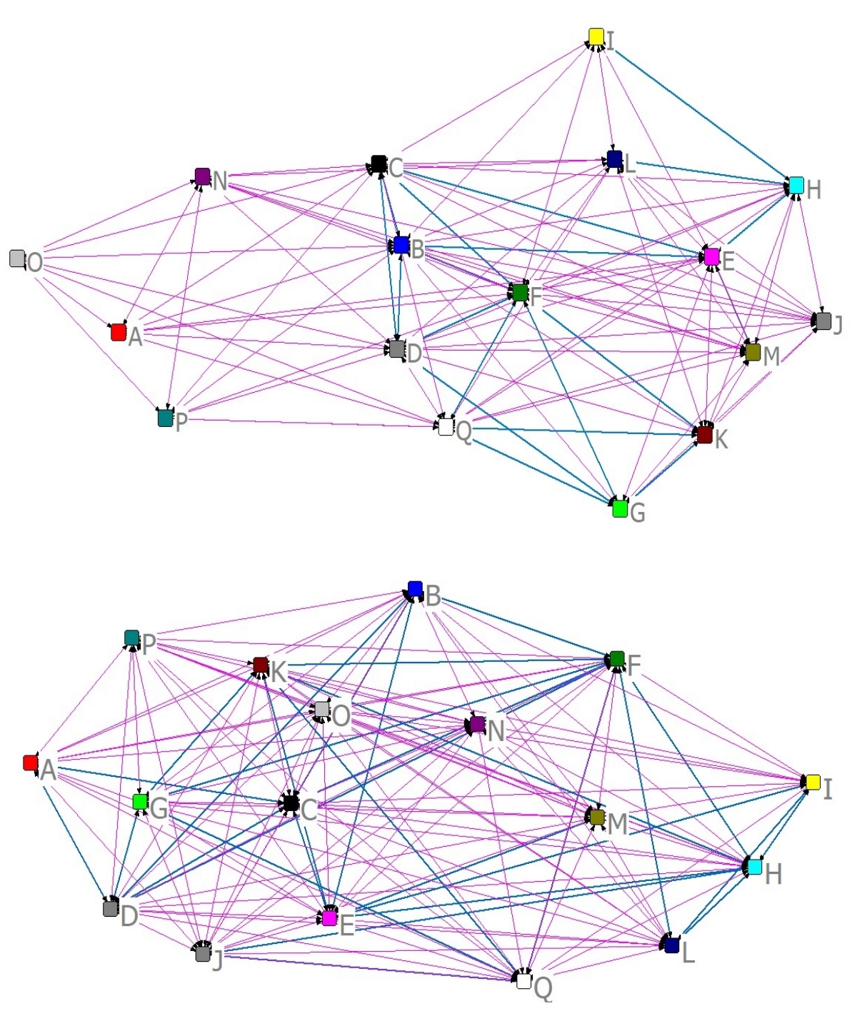
Hani Rice Terraces in Yunnan Province of China is listed as UNESCO world Cultural Heritage in 2014 and also Globally Agricultural Heritage Systems in 2010 as the marvelous human wisdom and its outstanding universal value to the human beings. Located in the core area of Hani Rice Terraces, Dayutang Village (DYT) and Pugaolaozhai Village (PGLZ) are small towns where the Hani nationality live. They are also typical agricultural and ecological tourism destinations attracting visitors from all over the world. However, interest disputes and governance among stakeholders have always been challenges to maintaining the sustainability of tourism at world cultural heritage sites. Consequently, it is of great significance to assess the governance of the village interest relationships from the perspective of stakeholders. Social Network Analysis (SNA) provides a good tool for explaining stakeholder relationships, though this has rarely been applied to studies of stakeholder relationship networks in tourism villages related to world heritage sites. This study used SNA to assess two typical tourism villages (DYT and PGLZ) in the Hani Rice Terrace core area with respect to stakeholders including local government agencies, businesses, communities, and pressure groups. Stakeholder relationships in the two villages were then analyzed from five aspects: network cohesion, network reciprocity, network core edge, network transmission, and network broker. The results are as follows. Firstly, the reciprocity between communities and local government agencies, communities and pressure groups is lower than the overall average level. Secondly, the marginal structure in the interest network is more obvious than the core structure, leading to the imbalance of interest relationships. Thirdly, the local government agencies of the two villages have relatively lower transitivity, while the local communities have the highest transitivity. Finally, the interest groups in two villages lack liaison roles. Based on these results, the corresponding suggestions were put forward. Firstly, shape a close interest relation among interest groups to form effective interest coordination mechanism. Secondly, strengthen the internal relationship among the interest groups to form the effective conservation and development force. Thirdly, make full use of the high reciprocity and high transmission feature of interest network. Fourthly, focus on decision-making power and voice power in the interests relation network in local communities to increase the power of the local communities. Last but not the least, cultivate liaison roles such as coordinator, consultant inside and among the interest groups.
With the fast pace of life in modern society, people are under pressure from work and life, so we should pay attention to the mental health problems of individuals. However, both daily living environments and tourist destinations can provide an opportunity for individuals to recover, and the attributes of different environments lead to different degrees of recovery. Are individual restorative effects in the tourism destination higher than those in the daily life environment? Further, are there significant differences in the restorative effects between urban and rural tourism destinations? Does the length of stay regulate the relationship between the environment and the restorative effects? All these questions are worth thinking about and discussing further. For these reasons, this study adopts a questionnaire survey method, using the paired sample t-test and mixed design analysis of variance, to explore the restorative effects of tourists in different environments and to provide a psychological explanation for this phenomenon. Firstly, the four dimensions of recovery experience, that is, relaxation experience, psychological disengagement, mastery experience, and control experience, scored higher in the tourism destination category than in the daily life environment category. On the basis of Goffman’s dramatic framework and organizational behavior theory, the macro-restorative effects brought about by the liminal experience function of tourism destinations are stronger than the meta-restorative effects of non-working leisure experience in daily life. Secondly, under the influence of traditional Chinese cultural values and Confucianism, the restorative effects of the urban environment as perceived by Chinese tourists are higher than those of the natural environment. This study differentiated between urban and rural tourism destinations from the perspective of tourists’ perception, and beginning with the two aspects of restoration experience, that is, effort-restoration and resource conservation, and taking into account the role of the environment, then found that the attributes of tourism destinations and the separation between daily life are perceived by tourists as a social situation with backstage functions,so the tourism destinations could promote individual recovery better than daily living environment. Additionally, the study found that the threshold function of the destination has a time limit, and tourists’ psychological response to the environment will change at different stages. The difference in threshold experience between urban and rural tourism destinations has an impact in the first few days. When the length of stay is extended, tourists are more familiar with rural tourism destinations, and the restorative effects brought about by destination attributes that are more inclined to natural environment characteristics are highlighted. Moreover, the intersection between urban tourism destinations and daily living environment is becoming more and more obvious. Under certain circumstances, the effects of effort-restoration of urban tourism destinations may be lower than those of rural tourism destinations. Therefore, the type of destination does not independently affect the restorative effects of tourists; it is regulated by the length of stay and related to the degree of tourists’ adaptation to the environment. This study enriches the research on environmental restorative effects from the perspective of experience and also helps to deepen the understanding of the strategies to improve restorative effects for academia and industry. At the same time, it provides a comprehensive research perspective for understanding the relationship between restorative effects, type of environment, and length of stay.
A detailed investigation of land use status is the basis of spatial planning conducted on National Land and the core of the producing basic map . Research towards creating a detailed investigation method for determining land use status can provide technical support for the converting land use statuses, which is favorable for promoting the scientific, rational, and operational results of conducting spatial planning of National Land. Presently, detailed investigations of land use are still in the stage of manual visual interpretation and data exploration, and there is practically no attempt to apply the method with a higher efficiency and accuracy. Therefore, this study proposes an image information extraction technique based on a combination of highly scoring remote sensing images and class attribute information of point of interest , kernel density analysis and object-oriented methods (for information extraction), and the current detailed method used to investigate land use types. eCognition 9.0 and ArcGIS 10.2 software are used to extract buildings and link POI attributes in two study areas, the town center and town edge, to identify the functional classes of each building. Information on the attributes of the POI is extended from point to area before the land types, based on the results of the Third National Land Survey, are used for a spatial overlay analysis that completes the classification of land in the study area. The results show that the overall accuracy of the training samples extracted by eCognition 9.0, when combined with the POI information-assisted land classification survey results, reaches 100% after the confusion matrix is tested for accuracy; when compared with the visual interpretation method, the method is useful in the study area. The accuracy of the segmented survey results reached 86.2%. In addition, the buildings in the town center are mainly high-rises, and their functions are mainly residential, scientific, educational, cultural, and related to health and commercial services whereas the function of buildings on the town edge are mainly residential, meant for logistics or storage, or are related to industrial and transportation services. In the future research, the central area of the town can be studied using a variety of methods to improve the accuracy with which high-rises are extracted; for the town edge, it is necessary to improve the discrimination and precision of the extraction of exposed land and concrete buildings while simultaneously increasing the extraction of roads and other shape objects to aid the determination of the function of buildings adjacent to them. The application of this method can greatly improve the efficiency of work and provide a new method and way of thinking about the precision, efficiency, and intelligence of basic spatial planning work conducted on National Land. Moreover, it will be of great significance for other applications and further research.
Coastal zone of Hainan is one of the most valuable areas of natural resources and also forms a good ecological environment. Based on a 30-years coastal data derived from satellite imagery, which includes coastline, mangrove, nearshore aquaculture ponds, artificial islands, and ports, this study analyzed the coastline changes and other spatial elements in the coastal zone of Hainan Island. The human activities that impacted on the coasts of Hainan were also evaluated. The indices used for the analysis were: Length Change Intensity (LCI), Index of Coastline Type Diversity (ICTD), and Index of Coastline Utilization Degree (ICUD). In this study, we found that: 1) the length of the coastline increased steadily from 1,655 km (in 1987) to 1,890 km (in 2017). In contrast, the natural coastline length decreased continuously from 1,565 km (in late 1980s) to 1,140 km (in 2017), with a proportion drop from 94.6% to 60.3%. The length and proportion of artificial shoreline increased remarkably, from 90 km (in late 1980s) up to 750 km (in 2017) and a proportion changed from 5.40% to 39.7%. 2) The diversity of coastline types decreased while the coastline utilization degree increased. From 1987 to 2017, the ICUD increased continuously from 237.34 to 285.03, indicating that human activities had an increasing effect on coastline changes. 3) Land and sea pattern changes were complicated, with the coastline expanding into the sea. Overall, the coastal land area increased by 107.49 km. A variety of human factors contribute for the continuous changes of the coastline. The change in the biotic coastline is mainly the result of competition between mangroves and aquaculture ponds, and the construction of ports and offshore artificial islands, which are also responsible for the land sea pattern reform. Since 2000, the length of the coastline of Hainan Island has increased largely due to the coastal construction projects that have augmented the artificial shoreline. Currently, it is still necessary to strengthen the protection and control of coastlines and promote their sustainable utilization. With the increase in general awareness about environmental protection laws and the implementation of coastal zone management and ecological restoration protocols, the coastal ecological environment will be largely protected and restored. This study contributes to a better understanding of the ecological environmental changes in the coastal zone of Hainan and provides scientific basis for the protection and restoration of its ecological environment. The study provides a scientific application paradigm for the effective use of coastal datasets to conduct research on the coastal environment.
Remote sensing technology for monitoring of water pollution has the advantages of wide monitoring range, fast monitoring speed, low cost, and long-term dynamic monitoring. To explore the applicability of the GF-2 earth observation satellite in the monitoring of organic pollution delivered to water bodies, this study extracted water body information from the normalized difference water index based on GF-2 earth observation multi-spectral data and used the Ratio Vegetation Index (RVI) to obtain the water quality classification and organic pollution distribution of six major rivers in the Guangdong-Hong Kong-Macao Greater Bay Area in March 2019. To reflect the water quality classification and water pollution distribution more clearly and intuitively, this study used ArcGIS software to visualize the water pollution information. According to their different degrees of organic pollution, the water bodies were categorized into the four levels of pollution-free, light pollution, moderate pollution, and heavy pollution, respectively, corresponding to the blue, green, yellow, and red colors in the figure, and the classification results of each river section were developed using area statistics. Finally, the water quality indexes of measured data were classified and evaluated according to the single water-quality parameter evaluation standard of surface water. The classification map of organic pollution was verified by comparing it with the remote sensing analysis results. The results of the study are as follows.: 1) The water quality of the study area is generally good. The Jitiemen and Jiaomen watercourses mainly have light pollution, whereas the Modaomen watercourse, Dongjiangnan tributary, Hengmen watercourse, and Hongqili watercourse are mainly pollution-free, with generally good water quality. 2) The distribution of organic pollution shows a spatial pattern. The main channel of the river is mainly a pollution-free water body; the two sides of the river have mainly light pollution, and the closed water body away from the main river has mainly medium pollution and heavy pollution. Timely and effective water pollution prevention and control measures need to be taken according to local conditions. 3) The extraction of organic pollution information from GF-2 multispectral data is feasible. The water bodies of JiTimen bridge, MoDaomen bridge, HongQili, and Jiao Men belong to the pollution-free class of water bodies. The ShatianShisheng is a water body of four types, with dissolved oxygen and ammonia nitrogen parameters exceeding the limit, and the ZhongShan port wharf is a water body of three types, with ammonia nitrogen parameters exceeding the limit. Both of these are mildly polluted water bodies with respect to organic pollution. The pollution levels of the six monitoring sections analyzed by remote sensing are consistent with the evaluation results of the actual monitoring sites in March 2019. The study concluded that GF-2 earth observation satellite multi-spectral data are accurate and reliable as a remote sensing data source for water pollution monitoring. These data can provide auxiliary information for decision-making pertaining to water pollution prevention and control in China. The research method of water body classification using the RVI implemented in this study is a semi-quantitative analysis method, which cannot be used to analyze specific water quality parameters quantitatively. The next step is to establish a chlorophyll concentration inversion model, which would allow the specific chlorophyll concentration data of each detected water body to be obtained quickly.
There are up to 44 islands and reefs illegally occupied by foreign countries in the Spratly Islands, that is a serious threat to China's national security. Therefore, the strategic value of the occupied islands and reefs in the Spratly Islands region should be evaluated. Previous studies concentrate on the period before large-scale construction in the region. Additionally, they lack consideration of the islands development potential. Considering this potential, radiation capacity, and carrying capacity, the present study investigated 26 influence factors, their respective assessment values were calculated. The subjective and objective integrated method was used to determine the weight of each factor. The linear weighting method was used to obtain the evaluation results of the strategic value of 44 islands and reefs occupied by Vietnam, Philippines, Malaysia, and Brunei. The results were spatially interpolated to identify their spatial pattern characteristics. The main results are as follows: 1) The strategic value evaluation of islands and reefs shows the gradient distribution characteristics. The Danwanjiao reef occupied by Malaysia, Nanweidao Island occupied by Vietnam, and Zhongyedao Island occupied by the Philippines are the ones with highest strategic value, and their evaluation values are 100, 98.42, and 97.09, respectively. The islands and reefs with lower strategic value were mainly sandbars and hidden shoals, such as the Orleana Shoal and Bombay Castle, with scores of less than 40. 2) The strategic value, radiation capacity, carrying capacity, and construction potential of islands and reefs all have a multi-core spatial distribution pattern, in which the spatial distribution pattern of their radiation capacity is the "NW-SE band", the areas of highest and high grades extend from northwest to southeast of the study area and decrease to both sides (northeast and southwest). There are two core regions and two secondary core regions in the pattern of radiation capacity. The spatial distribution pattern of carrying capacity shows a "horizontal strip", which decreases from north to south, in which there is one core region and two secondary core regions. There are three core regions and two secondary core regions in the spatial distribution pattern of island potential and strategic value of islands and reefs. 3) Vietnam occupies the most islands and reefs and has a wide spatial distribution. In the spatial distribution pattern of strategic value of islands and reefs, there is one core region and two secondary core regions closely related to Vietnam. Bishengjiao, Liumenjiao, Nanhuajiao, Wumiejiao, and West reefs are occupied by Vietnam and have a great potential for building islands and reefs, as their geographical location is of great strategic significance. Further construction would support the core areas of islands and reefs occupied by Vietnam, which could lead to a pincer attack on China's garrison islands and reefs, thereby requiring close attention.
Coral shingle cays are distributed widely around coral reefs and islands in the South China Sea; however, their formation and evolution are little understood. A Digital Elevation Model (DEM) of three coral shingle cays at the Yongshu, Ximen, and Anda reefs, respectively, in the Nasha Islands had been built after they were investigated in 2017. Based on the modern DEMs of the shingle cays, different DEMs of the shingle cays were reconstructed at the past four intervals of 2011 (2009), 2013, 2015 and 2017 by remote sensing analysis; thus, the geomorphic features and evolution that the cays underwent from 2009-2017 was revealed. During this periods, the shingle cay at the Anda Reef experienced near constant erosion, shrinking continuously and showing losses of 50%, 70%, and 72% in average height, area, and volume, respectively, as part of a general declining trend. The shingle cay at the Yongshu Reef was dominated by horizontal and vertical accretions; its average height, area, and volume increased by approximately 21%, 62% and 103%, respectively, from 2011-2017. The area of the shingle cay at the Ximen Reef showed horizontal accretion, with an increase of approximately 160%, but its average height declined by approximately 31% and changes in its volume were insignificant. At both the Yongshu and Ximen reefs, the shingle cays moved eastward or southeastward into the lagoon or inner reef flat, with the centroid being displaced 41.18 m and 55.71 m, respectively; the average rates of movement were 0.6 m/month and 0.8 m/month, respectively. In contrast, the shingle cay at the Anda Reef moved northwestward towards the outer reef flat for a larger distance (193.1 m) and at a greater velocity (2.1 m/month) than the other reefs moved. The evolution of three shingle cays was controlled mainly by monsoon- and typhoon-driven waves, and was influenced by differences in hydrodynamics based on their locations and the shapes of the reef flat. As a result, the three shingle cays showed two different modes of evolution: migration and shrinking towards the outer reef flat and migration and extension into the lagoon or inner reef flat. The geomorphic evolution of these coral shingle cays in the Nansha Islands provides an important scientific basis for extensive study of the geomorphic development, and the dynamic mechanism thereof, of coral islands in the South China Sea. Further research will combine long-term remote sensing analysis and regular field observations of the ecology, sedimentology, and hydrodynamics of the coral shingle cays and neighboring reef areas, and focus on the long-term processes of coral shingle cay formation and evolution to reveal the key environmental factors thereof and the mechanisms affecting them.
Financial inclusion is important for all sectors of society, and ensuring that both urban and rural residents have access to various types of financial services is the cornerstone to developing an optimum financial system. Based on data obtained from commercial bank branches (provided by the China Banking and Insurance Regulation Commission), this study aims to analyze the spatial and temporal differences between areas with respect to financial inclusion within China, determine whether establishing physical bank branches can increase financial service usage, and ultimately determine whether geographical inclusion can lead to business inclusion. The findings are as follows: different types of commercial banks have distinct spatial distributions. In this respect, compared to the prevalence of Large State-owned Commercial Banks (LSCBs), Joint-Stock Commercial Banks (JSCBs) and Foreign Commercial Banks (FCBs) are preferentially located in eastern areas before spreading to inner regions and then from the middle to western regions. City Commercial Banks (CCBs) have much fewer branches than LSCBs and their branches tend to be established in eastern China, because only relatively developed cities are capable of opening their own CCBs. Rural Commercial Banks (RCBs) are more common than CCBs and are mainly located in rural areas within counties and townships; RCBs are more usually established in such areas because the degree of urbanization in western areas is much lower than that in eastern and central regions. Based on the distribution, a system GMM model is adopted to determine whether geographical inclusion promoted business inclusion during the period from 2005 to 2017; the findings are as follows: 1) the establishment of physical branches typically increased the use of financial services, but there were variations in the promotional effects of the different commercial bank types throughout the various economic areas and during different periods. 2) In the eastern region, JSCBs and FCBs were major forces that continuously promoted usage, whereas the effect of LSCBs was unstable and they only exerted a positive influence between 2009 and 2012. 3) LSCBs and CCBs played key roles in the northeastern area, but the promoting effect of the latter only emerged from 2009 (slightly later than that of the former). 4) LSCBs and JSCBs significantly improved business inclusion in the central region throughout the research period, whereas both LSCBs and RCBs improved business inclusion in the western area; the promoting effect of RCBs occurred in 2013 (which was significantly later than that of LSCBs). The spatial and temporal disparities are related to two factors: first, the geographical differences between promoting effects relate mainly to the spatial distribution of bank branches and the service preferences of customers. For example, it is possible that LSCBs are more popular in the northeastern area because the risk-adverse characteristics of customers drive them to adopt services provided by state-backed and controlled agencies. Second, the temporal variations relate to the banks being established in different periods and the timing of guidance policies.
Urban metro is increasingly becoming the most important component shaping sustainable urban spatial structure and daily life in China; consequently, the number of studies conducted on urban metro network planning has increased rapidly during the last decades. These studies have primarily focused on enhancing operational efficiency to achieve certain keytechnical objectives. However, little attention has been paid to studying the spatial synergy between the urban metro network and public amenities, even though this is crucial to the promotion of social equity intransportation and facilities planning. Improving the role of metro networks to facilitate greater access to public amenities could encourage better utilization by the urban population. The importance of leveraging metro networks to promote the use of and access to leisure amenities would subsequently result in a higher quality of life. Therefore, it is essential to incorporate spatial synergy to the planning and evaluation of urban metro networks. Using the city of Shenzhen to conduct the case study, this research aims to evaluate the spatial synergy between urban metro networks and leisure amenities indifferent network construction phases. The Shenzhen metro planning and construction project involved three phases, i.e., PhaseⅡ(2004-2011), PhaseⅢ-1 (2011-2016), and PhaseⅢ-2 (2016-2020). Using the ArcGIS 10.4 software platform, an optimized two-step floating catchment area method was used to build an evaluation model. The results were analyzed using spatial visualization and graphical representation in the form of a Lorenz Curve. First, the findings show that the accessibility of metro-based leisure amenities in urban metros has been continually improving over time. The accessibility there of in suburban areas has been decreasing, but this trend is gradually being reversed with the renewed focus on metro networks in suburban areas.The synergy gap has been widening particularly during phaseⅡand phaseⅢ-1 butis expected to narrow in the upcoming Phase Ⅲ-2. Second, the top 50% of communities ranked onthe basis of accessibility of metro-based leisure amenitiesaccount for 25% of the total municipal territory and 40% of the residential population. Urban metro network expansion will facilitate more equitable access and better quality of life forthe population. The root cause of the inequality is primarily the spatially unbalanced population distribution across urban spaces. Third, it is essential to highlight areas which exhibitthe largest mismatch in terms of the metro station networks, leisure amenities, and population distribution. For instance, the Luohu district facilitates significantly better accessibility to metro-based leisure amenities compared to that available via the metro network coverage across the urban area. This implies that the majority of leisure amenities in the Luohu district have been connected by metro lines. On the contrary, a large portion of the leisure amenities in the Nanshan district were not previously accessible by metro. This changed when new metro lines extending to the southern part of the Nanshan district were built, enabling access to sufficient leisure amenities. This study clarified thespatial synergy between urban metro construction and leisure amenities. Understanding this synergy will facilitate better accessibility, efficiency, and equity among different segments when the station locations are decided, network planning is conducted, and sites are selected for new leisure amenities.
In the vast rural areas of southern China, ancestral halls, being material space carriers with common historical culture and value identification as the core, play an important role in the cultural shaping and governance of rural society. However, with the rapid spread of modern elements and modern culture, many Chaoshan rural areas are facing the dilemma of cultural identity and cultural confidence. What kind of cultural identity, local affiliation, and emotional expression do Chaoshan ancestral halls bearing local culture and local significance have in the daily practice of local subjects? How to construct the local meaning around Chaoshan ancestral hall and then realize the cultural space with multiple connotations? On the path of seeking cultural confidence in rural areas, what is the internal logic of Chaoshan ancestral hall and rural governance, and how to achieve the revitalization and co-governance of rural regional space? These are questions worth thinking about and exploring further. In view of the same, this article researches the breakthrough point, with Chaoshan ancestral hall and its links to the local villagers, ancestral hall management personnel, and grass-roots workers as the research objects. We used the network file analysis, in-depth interview, and questionnaire-based survey research methods, exploring the Chaoshan ancestral hall where the construction process and the culture mechanism to better resolve the Chaoshan multi-agent ancestral hall and the village of dialogue and interaction. First, Chaoshan ancestral hall, as a material entity connecting and maintaining rural social network, plays a significant role in shaping the sense of place of rural spatial subjects. To be specific, Chaoshan ancestral halls have formed rooted cultural identity and shaped common symbols, cultural concepts, and behavioral norms in the long-term historical evolution, which act on local cognition, emotion, and intention, making Chaoshan ancestral halls continuously strengthen local perception and local practice of rural subjects. Additionally, Chaoshan ancestral hall has become a very local physical landscape in rural areas through localization and stability of architectural form, highlighting local characteristics, and local significance in increasingly homogeneous rural areas. The construction of locality is a process from material to spiritual, the “time and space” of Chaoshan ancestral hall represents the transformation from materiality to spirituality, and the meaningless place is shaped into a place with roots and attributes. The cultural confidence in rural areas is in an urgent need of the construction of local identity and local attachment so as to realize the transformation of rural areas from being culturally “lost” to culturally “rooted”. The interaction between Chaoshan ancestral hall and many subjects in rural areas forms a sense of place, which provides an emotional and cultural basis for rural governance. Admittedly, rural regional space has its own complexity, so rural governance is bound to be multi-subject, multi-dimensional consultation, and co-governance. Based on local culture and material function, multi-subject creation is an important mode of rural governance. Clan council derived from Chaoshan ancestral hall plays an irreplaceable role in coordinating and dealing with rural affairs.
Rainfall leads to significant impacts on urban road traffic, such as traffic congestion and traffic accidents, resulting in detrimental effects on traffic efficiency. Exploring the changes in road traffic efficiency and their influencing factors in rainy weather is of great significance for urban traffic planning, management, and traffic information release. Due to the complexity of urban road network and diversity of transportation demands, rainfall, on one hand, causes flooding on the road and reduces visibility, both of which reduce the driving speed; on the other hand, rainfall also reduces unnecessary trips, resulting in reduced traffic flow, which increases road speed. However, most previous studies focused on changes in the average traffic efficiency of all roads and ignored the differences among different road types. Moreover, there is a lack of related literature analyzing the influencing factors of road speed changes on rainy days. Therefore, this study uses the rainfall monitoring data and large-scale taxi GPS data of Shenzhen as the data source to analyze the differences in speed change on large-scale urban roads and their influencing factors. First, the percentage difference in road speed between sunny days and rainy days was calculated. It was found that rainfall did not always reduce road speeds: approximately 30% of the road speeds in the study area increased. Then, a multivariate linear regression model was applied to analyze the different effects of certain influencing factors, such as rainfall intensity, traffic volume, road grade, and the speed on sunny days, on two types of roads (i.e., speed decrease and speed increase). The results show that for the roads with reduced speed, the rainfall intensity, traffic volume, speed on sunny days, and coefficient of vehicle speed variation on rainy days have significant negative correlations with the speed decline rate. For example, the heavier the rainfall is, the faster the road speed drops. The number of bus stops has a positive correlation with the speed decline rate. For roads with increased speed, the rainfall intensity and coefficient of vehicle speed variation on rainy days have significant positive correlations with the speed increase rate, while the speed on sunny days is negatively related to the speed increase rate. For the two types of roads, the road grade is not a significant influencing factor. This research expands our understanding of the impact of rainfall on urban road traffic efficiency and can provide useful insights for the operation and evaluation of various road facilities in urban areas.
From August 27 to September 1, 2018, there was persistent heavy rainfall in Guangdong, which was one of the top ten weather events in Guangdong Province during 2018. We analyzed this rainstorm process by using the ECWMF global reanalysis ERA-Interim data, encrypted data from the Guangdong Province automatic observation station, China's surface annual value dataset (1981—2010), and daily and long-term mean average long-wave radiation data from the NOAA along with wavelet analysis, band-pass filtering, and regression analysis methods. We discuss the impact of atmospheric oscillation at low latitudes on the process of this continuous rainstorm in order to provide reference for forecasting this type of rainfall event. The results showed that the rainstorm lasted for a long time and affected a large area. The main weather system that affected the rainstorm was monsoon depression, accompanied by a shear line and low-level jet. Tropical low pressure named 92W on August 25 made landfall in Fujian after a westward shift, and then formed a monsoon low pressure. Due to the sub-high block, the warm and humid airflow brought by the southwest monsoon could not move northwards; hence, the monsoon low pressure was maintained and continued to develop, gaining long-term control of most of the southern coast whilst moving slowly westwards. The mid-level of the troposphere strengthened and extended to the northern part of the South China Sea. The southwest rapids intensified, the low pressure center appeared to the northeast—southwest—turning trough, the water vapor flow reached its maximum, and the coastal areas experienced a wide range of extreme precipitation. After the monsoon low pressure moved westwards and weakened, together with the northwest high pressure of the South China Sea, extreme precipitation peaked along the coast of Guangdong. The precipitation across Guangdong from July to September 2018 had a significant 6-13 days oscillation feature, which was mainly affected by convective oscillation in the west Pacific Ocean and the tropical north Indian Ocean. After convection formed in the west Pacific region, it continued to spread northwestwards and reached the coastal areas of southern China. The airflow from the tropical north Indian Ocean reached the coastal areas of south China via the Bay of Bengal and the Indo-Chinese Peninsula, thus forming a vertical circulation with a low frequency oscillation, which was conducive to water vapor transport and convective development in the coastal areas of south China. The combination of the two was more conducive to the occurrence of continuous heavy rainfall in Guangdong.