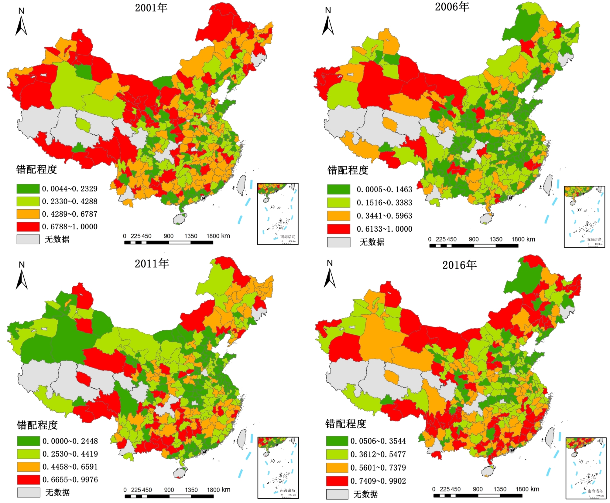
China's social and economic development is currently transitional. There is great incompatibility between the traditional construction land allocation model and the requirements of social and economic development, marked by a prominent contradiction between the supply and demand of construction land that has severely restricted the sustained and healthy development of China's social economy. Improving the efficiency of land resource allocation has become a new driving force for economic growth. With the limited driving power of this factor input for economic development, it is important to explore the occurrence and mechanism of rare construction land resource misallocation to secure the structural benefits of construction land allocation and sustainable economic development, as correcting construction land misallocation would greatly advance land supply-side reform and improve the efficiency of land resource allocation. To explain the mechanism of construction land misallocation, the article builds models for the measurement of both construction land misallocation and its mechanism, applying methods such as spatial autocorrelation model and the spatial Dubin model (SDM). Using these models, we focus on the space-time characteristics, driving factors, and spatial effects of construction land misallocation in China from 2001 to 2016. The sample data in this article come from 235 prefecture-level cities in China. The results show that the misallocation of construction land in China tends to decrease, followed by an increase, with a spatial distribution high in the West and low in the East. There were obvious spatial agglomeration and association features of construction land misallocation and its influencing factors in China, but the spatial correlation effect has weakened. Land financial dependence, industrial structure optimization, and market development have a significant negative impact on construction land misallocation, while government corruption and economic development have a significant positive impact and exert a space spillover effect. We find that the misallocation of construction land in our country is widespread and shows an upward trend. Changing the mode of economic development, increasing government governance, and improving market mechanisms and regional integration can effectively alleviate the misallocation of regional construction land. This paper is significant in discussing the driving factors of construction land misallocation from both theoretical and empirical perspectives, and in analyzing their spatial effect for the first time. It provides research directions and ideas for quantitatively exploring the problem of land resource misallocation, and indicates a feasible way to correct the misallocation of land resources.
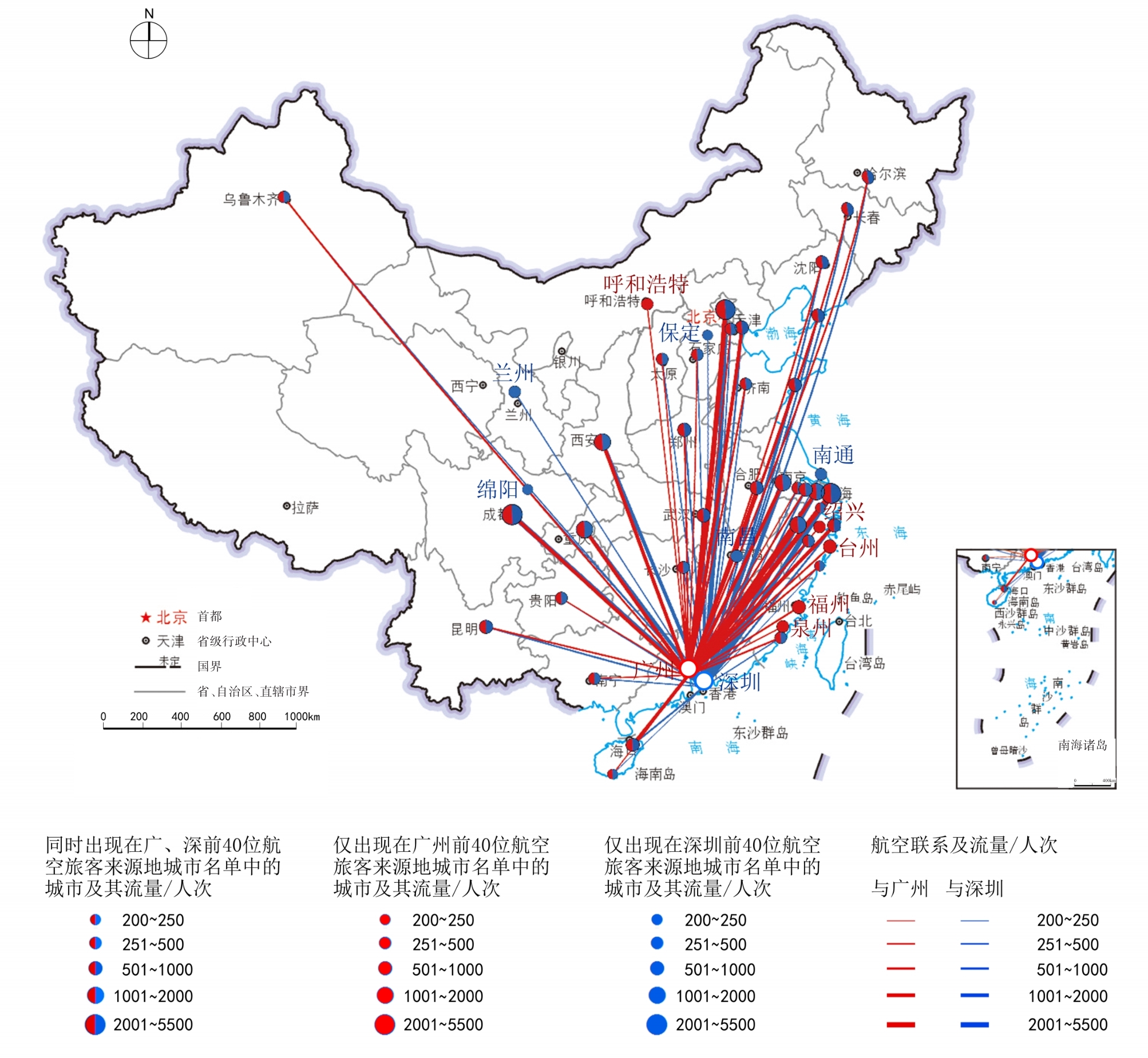
Over the past forty years of reform and opening up, the urban center system in the Pearl River Delta Region has been rapidly restructured. Its two central cities, Guangzhou and Shenzhen, have been fiercely competing in the field of economic development. Dealing with the functional positioning of the two cities has constituted a long-term concern for regional planning and policy making. Under the new circumstances of the Guangdong-Hong Kong-Macao Greater Bay Area, there is an urgent need to clarify the functional positioning of the two central cities of Guangzhou and Shenzhen. Further, there is a need to coordinate the relationship between competition and cooperation, the premise of which lies in the dynamic and accurate identification of urban functional characteristics. Previous studies directly used economic and industrial statistical data to study and analyze urban functions. However, due to the relative low frequency and high cost of data collection and analysis, it is difficult to carry out real-time analysis using these data. Based on the theoretical understanding of the projection of city functions to the city network, this article uses inter-city air passenger flow as its research medium. Further, it uses the air passenger flow data extracted from Baidu location-based services (LBS) big data. Taking the Chinese city network as its overall scope, it adopts the following two approaches. First, it compares the functional characteristics of the cities where the air passenger flows toward Guangzhou and Shenzhen are sourced. Second, it compares the functional characteristics of the employment places in the two megacities of Beijing and Shanghai, where the air passenger flows toward Guangzhou and Shenzhen are sourced. Therefore, the functional attributes and the functional areas of the source cities are used as the basis for identifying the comparative functional features of Guangzhou and Shenzhen to judge their overall functional characteristics in the Chinese urban network. The research results show the following. 1) First, compared with Shenzhen, Guangzhou's network connection with cities across China and Beijing and Shanghai focuses on administrative management and business functions. It plays the role of an administrative and business center within the spatial scale of the Pearl River Delta urban agglomeration. 2) Second, compared with Guangzhou, Shenzhen focuses on technological innovation, finance, and high-tech manufacturing functions, and plays the role of a technological innovation and financial center and high-tech manufacturing base under the scale of the Pearl River Delta. 3) Third, as the two major service industry centers in the Pearl River Delta region, Guangzhou focuses on public and general producer services, and Shenzhen focuses on advanced producer services such as finance and technological research and development. Shenzhen has a higher status within the Chinese urban network system based on the producer service industry. The method provided by this article, which involves locational big data to flexibly extract urban functional characteristics from the city network, is novel. Further, it can serve as a supplementary approach to the studies on urban functions which relied on traditional economic and industrial statistics. Meanwhile, the research results of this article provide evidence for deepening the theoretical understanding of the urban function-space-network mapping relationship.
A highly educated workforce is an important driving factor for urban innovation and development. A better understanding of spatial patterns and location determinants of highly educated workers is valuable for designing policies to attract them. The existing literature has investigated the impacts of economic variables and urban amenities on the patterns of highly educated workers. However, the relationship between urban amenities and highly educated workers needs to be investigated further. Moreover, few studies have examined the impact of urban size on the agglomeration of highly educated workers. Thus, this study employed a spatial analysis method to examine the pattern of highly educated workers across 300 cities in China, based on 2010 census data. We used a negative binomial regression model to identify the determinants of highly educated workers' locations. The results are numerous. First, the size of highly educated workers varied greatly among cities of different ranks, and its rank-size distribution was consistent with power function characteristics. It was characterized by spatial convergence and zonal differentiation from East to West. Highly educated workers were distributed mostly across the eastern coastal area, the central-southern area of Liaoning peninsula, the Harbin-Changchun urban agglomeration, and in inland provincial capitals. Second, the share of highly educated workers in total employment in the resource-dependent cities of north China and eastern coastal urban agglomeration was significantly higher, while it was obviously low in central and southwest China. Comparing the rank-size distribution characteristics of highly educated workers along with their total employment, the cities with rich attractions for highly educated workers were mainly located in Inner Mongolia, Northeast China, the Beijing-Tianjin-Hebei metropolitan area, the Shandong Peninsula, the Yangtze River Delta, the Pearl River Delta, and inland provincial capitals. Third, the estimated results show that the spatial pattern of highly educated workers was affected by urban amenities, economic opportunities, and the agglomeration effect. At the national level, economic opportunities, city size, and housing prices dominated the spatial pattern of highly educated workers, while the cool summer climate, high quality education resources, and recreation and transportation resources also played important roles. Fourth, the distribution of highly educated labors was affected by both economic opportunities and amenities, but the role of amenities was quite different in different size-ranked cities. The main amenity factors for the disparities of highly educated workers in large cities were found to be those of temperature in January and July, high-quality early childhood education resources, recreation resources, and traffic conditions. For the medium-sized cities, the dominant amenities included high-quality primary and secondary education resources and cultural and artistic services. Regarding the disparities of highly educated workers among small cities, the main contributing amenity factors were high-quality preschool and middle-school education resources, high-quality medical resources, recreation resources, and air quality. This study supports previous opinion that the amenities contribute to attracting talent. It also reveals the role of the agglomeration effect in the spatial distribution of the highly educated labors, which enriches our understanding for the location choice of highly educated workers in economic geography. This study enlightens us in the sense that the policies to attract talent should not only take labor market into account but also work to improve the amenities that such people work in.
China is comprehensively advancing the reform of land and space planning. The delineation of urban development boundaries is an important measure to scientifically guide the adjustment of land and space structures, and realize high-quality space development. At present, no scholar has used the knowledge map method to conduct a comprehensive analysis of the research on the development boundary of Chinese cities and towns. Therefore, based on the data on HowNet from 1996 to 2019, we use CiteSpace to create a knowledge map of China's urban development boundary research, and systematically categorize the research trends and development context. This article is expected to provide a new research perspective for the improvement of delineation accuracy and control effectiveness of urban development boundaries in the new era. The results show that the domestic development boundary research has gradually prospered, and cooperation among scholars has shown "integrated dispersion and partial closeness." However, there is inadequate cooperation among the relevant research institutions. In addition, the research hotspots are diverse and are guided by different national policies and regulations and time zones. This article divides China's development boundary research into four stages: theoretical exploration, deepening understanding, delineation exploration, and management. It shows that domestic development boundary research has evolved from focusing on controlling urban sprawl, to protecting cultivated land, ensuring ecological security for shaping beautiful land, controlling urban forms, promoting urban transformation, taking into account equal development rights, and ensuring sustainable urban development. Finally, we conducted an in-depth study and discussion on the delimitation and management of future development boundaries, adjustment and evaluation, and humanism. Based on our findings, we make the following five policy recommendations: improve the ecological compensation mechanism, delimit the development boundary based on the principle of ecological priority; unify the boundary delineation accuracy of each planning level; formulate diversified development and protection management and control models; implement the boundary trial period system to strengthen the flexibility of boundary management; and improve the people-oriented. The boundary of the center delimits the management system.
In the past ten years, public-related economic crimes have shown an explosive and blowout development trend along with the rapid development of the financial market. A Pyramid Selling Crime (PSC) is a public-related economic crime and a social problem that needs to be solved urgently. PSC includes a strong spatial decision-making process. Whether its spatial distribution is related to specifically built environmental elements is a typical geographic issue and is worthy of being included in the study of criminal geography. However, research on PSC is relatively scarce, and more analyses of its causes, methods, and legal issues are needed. There is little research on the temporal and spatial pattern evolution and its influencing factors from a geographical perspective. This study took Wuhan city as an example and was based on the PSC data of the China Judgment Document Network and the Point of Interest (POI) data related to the urban built environment. The nearest neighbor index method and nuclear density estimation method were used to study the changes in the spatial patterns of PSC sites in Wuhan from 2012 to 2019. Thereafter, the geographic detector method was used to analyze the built environment factors influencing the distribution of PSC sites to grasp the temporal and spatial laws of Wuhan PSC sites and their relationship with the built environment. In addition, this method provided a reference for the efficient prevention and control of PSC in Wuhan. The results were as follows: 1) PSCs in Wuhan were concentrated and distributed spatially presenting a characteristic concentration in the city center and having three centers in Dongxihu District, Huangpi District, and Hongshan District. These centers were mainly urban commercial centers, transportation hubs, urban villages, and urban-rural junctions, which are basically similar to the distribution characteristics of high-risk areas of robbery, snatch and theft crime in Wuhan. PSCs had the same characteristics as general crimes and conformed to the "law of concentration of crimes." However, the spatial distribution of PSCs also had its particularity. For example, PSCs included places associated with science, education, culture, financial insurance, etc., showing a trend of high-quality and high-yield. 2) During the 2012-2019 period, the distribution of PSC sites in Wuhan changed from a small number and constant change in the early stage to a large number and relative stability in the later stage, stably concentrating in transportation hubs, commercial centers, or universities surrounding suburban areas where there is a large flow of people and a complex social environment. At the same time, with the expansion of the city, PSC presented a trend of moving from the city center to periphery areas. The urban-rural fringe area also became a high incidence area of PSC. 3) The spatial pattern of PSC sites in Wuhan correlated with multiple built environmental factors, especially the facilities of sports and leisure, shopping malls, companies and enterprises, and commercial residences. The interaction and influence among the various facility factors were greater and more significant, indicating that the formation of the spatial pattern of PSC sites in Wuhan was the result of the combined effects of multiple factors. Based on these conclusions, some suggestions and measures were proposed for Wuhan to effectively prevent PSC.
With the continuous increase in the rate of urbanization, more attention is being paid to quality of life in cities. At present, China's major cities are facing multiple challenges, including resource shortages, environmental pollution, population congestion, traffic congestion, and inequality of public service facilities, all of which have become controversial issues affecting the development of high-quality human settlements. Taking Changsha City as an example, this study attempts to solve the problems of incomplete physical examination elements, slow data update, and previously inconsistent evaluation standards. Under the guidance of problems and objectives, a scientific, comprehensive, applicable, and operable urban physical examination index system was built to provide effective support for the comparative analysis and accurate evaluation of urban development positioning. Based on remote sensing images, social open big data, and statistical data, this study constructed an urban physical examination index system from eight aspects: ecological livability, health and comfort, safety and resilience, convenient transportation, style and features, tidiness and order, multiple inclusiveness, and innovation vitality. The evaluation standard value was determined from the perspective of vertical national standards and planning references, along with a horizontal comparison of cities at the same level. The normalization method and analytic hierarchy process were used to calculate and evaluate the urban natural background and operational signs. The findings were as follows: 1) The overall human settlement of Changsha is good, and the comprehensive score of each aspect above 0.7. The city has a high degree of ecological livability and cleanliness, but the aspects of traffic convenience and safety resilience need to be improved. There is still room for improvement in style and characteristics, health and comfort, innovation and vitality, and diversity and inclusiveness. 2) The level of thematic development in each district and county is uneven. Yuelu District has the highest average score, while Kaifu District and Tianxin District have the most balanced development levels in terms of different aspects. On the basis of retaining the regional functional characteristics, each district and county should focus on solving development and narrowing the gap with other districts and counties. 3) The indicators of population density in the central urban area, number of days with good air quality, and mortality rate of 10,000 vehicles are at the highest level, but there is still a certain gap with the urban development demand in terms of complete coverage of convenience service facilities, residential building renewal and development, and group inclusion, among other aspects. According to the results of urban physical examination based on multisource data, in the future Changsha City needs to be solutionoriented, accurately manage "urban disease," and strive to improve the life satisfaction, happiness, and sense of belonging of urban residents. This study could provide reference research ideas for the fusion of static statistical data and dynamic emerging data derived from urban physical examination, the construction of a scientific and comprehensive index system, and the establishment of horizontal and vertical evaluation standards. At the same time, it could provide decision support for the diagnosis of prominent urban disease problems in Changsha and the better management of the city.
Pakistan is a influential country in South Asia and an important fulcrum of "The Belt and Road Initiative." The study of its urban system can promote the understanding of Pakistan and provide references for related cooperation. This paper conducts a more comprehensive empirical analysis of the scale structure, spatial structure, and functional structure characteristics of the urban system, based on existing research and on the census data, natural environment, economic industry, and traffic network and other public data. It uses the analysis methods of the urban system pyramid, Gini coefficient of urban scale and nuclear density analysis, and analyzes the endogenous and exogenous factors of the urban system. The results were as follows: 1) First, regarding scale structure, the overall distribution of the urban scale is relatively concentrated, showing characteristics of both "large urbanization" and "small urbanization." The development of intermediate-level cities is delayed, and the urban population pyramid is roughly shaped as an hourglass. Regarding spatial structure, the urban system of Pakistan embodies the coexistence of differentiation and integration, forming different urban density patterns in the East and the West and a provincial urban system with its own characteristics. However, the spatial structure of towns in the southeast-northwest region shows an integration trend. The eastern region gradually formed the urban agglomeration core areas of Karachi and Lahore, and the urban agglomeration areas of the Islamabad-Rawalpindi metropolitan area, Peshawar, Multan, Sukkur, and Hyderabad, with a "seven"-axis distribution in the southeast-northwest. Regarding the functional structure, there are three national centers, two regional centers, and some important industrial and transportation node cities. 2) The urban system is formed under the influence of endogenous and exogenous factors. Regarding endogenous factors, natural environment factors constitute the basis of urban system evolution; the intensity of the economic industry and spatial agglomeration determine the basic pattern of the urban system. The joint effect of terrain and traffic transforms the space-time distance, resulting in the difference of urban systems between the East and the West. The relatively independent social and administrative factors of each province cause the differentiation of the urban systems in each province. This process is indirectly affected by exogenous factors such as international investment and trade, geopolitics, and the China-Pakistan Economic Corridor. 3) The China-Pakistan Economic Corridor will strengthen the motivational force of urbanization in Pakistan, promote the transformation of the "seven" urban development axis into the "two vertical and three horizontal" urban development axis system, and promote the development of western cities. Suggestions for the overall policy of Pakistan's urban system include: (1)promoting the industrialization process, strengthening the power of urbanization, and promoting the development of cities at all levels, especially the intermediate level cities. (2) Further, it proposes strengthening integration development with the world market, promoting the development of cities in the southern coastal areas and the transportation links with inland cities, as well as the development of cities along the line. (3) Finally, it suggests reducing the administrative and social system barriers between provinces, reducing the distance and division of factor flow, and accelerating the process of urban system integration.
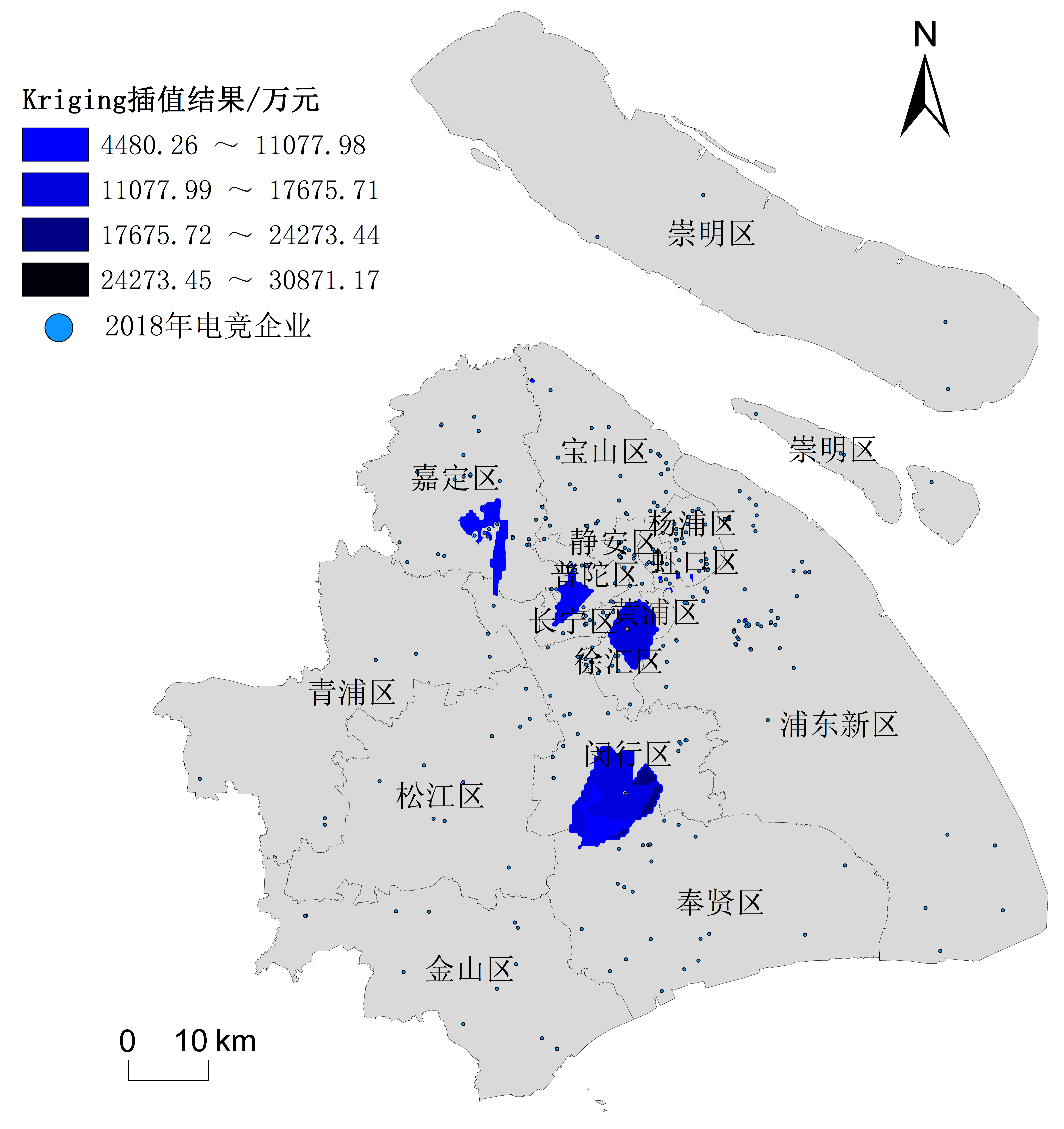
As an emerging industry formed by the integration of multiple industries, the e-sports industry contributes to urban development, economic growth, and promotion of urban image owing to the characteristics of low pollution, strong driving effect, and high social influence. However, the e-sport industry is a new industry with limited studies about the general features, evolutionary mechanism, and spatial dynamics. As an e-sports industry center in China, Shanghai has the most complete e-sports industry chain and the largest industrial scale. This study takes Shanghai as a classical case to explore the spatial evolution process, features, and influencing factors of the e-sports industry using the spatial analysis methods, including the kernel density estimation, nearest neighbor index, and the Kriging spatial interpolation analysis based on the data mining of Shanghai e-sports enterprises from 2006 to 2018. The results show that, first, according to factors such as historical background, policy support, and development characteristics, the e-sports industry in Shanghai can be divided into the initial stage from 2006 to 2010, the rapid development stage from 2010 to 2014, and the explosive growth stage from 2014 to 2018. Second, the spatial distribution of the e-sports industry in Shanghai has evolved from a dual-core aggregation to a multi-core aggregation with the characteristics of central aggregation and simultaneous outward expansion. The south and north are the main directions of the expansion of e-sports enterprises. Third, high-capital e-sports enterprises tend to focus on software parks and universities in the surrounding area. There are currently four high-capital hotspots, namely, Zizhu Science Park in Minhang District, Zhaojiabang Road in Xuhui District, Lantian Enterprise Development Industrial Park in Jiading District, and Tiandi Software parks in Putuo District. These hotspots will have more opportunities to extend more competitive e-sports enterprises in the future because spin-off firms can inherit excellent capabilities from the parent firms. Fourth, based on the analysis framework of agglomeration economy—enterprise spin-off—institutional environment, this study analyzes the evolution mechanism of e-sports industry cluster in Shanghai. The agglomeration economy plays a centripetal role, the enterprise spin-off enables new enterprises to inherit successful routines from the parent company, and the institutional environment is conducive to the formation and management of industries. Compared with previous studies which showed that the government plays a smaller role in promoting the cultural industry, the development of the e-sports industry is affected more by the institutional environment. Finally, at an urban scale, government policy planning has a guiding effect on the location selection of the e-sports industry. High-quality human resources, economic development level, e-sports market environment, and transportation convenience are the key factors for the aggregation of e-sports enterprises. In addition, compared with traditional industries, the e-sports industry has the characteristics of competition as a sporting activity. Furthermore, the excitement of competition and the holding of big e-sports events will have a significant impact on the development of the e-sports industry. This study explores the spatial-temporal pattern, evolution process, influencing factors, and evolution mechanisms of the e-sports industry in Shanghai from the perspective of evolutionary economic geography. This study verifies and enriches the theory of evolutionary economic geography from an empirical perspective, providing a theoretical basis for optimizing the spatial distribution of the e-sports industry, developing an e-sports industry cluster district, and enhancing the urban cultural brand. It also provides a decision-making reference for other cities to develop the e-sports industry.
The urban-rural transition zone has obvious characteristics such as urban expansion transition, dynamic spatial structure, and a diversified human environment. It is of great significance to study the spatial interaction intensity between urban and rural transition zones. It will strengthen the cohesion of the Urban-Rural Transition Zone, promote the circulation of various elements between cities and villages, and improve the regional development capacity and competitiveness of urban and rural areas. There exists research on the change of urban spatial characteristics, the expansion of the urban outer circle, and its motive force. However, little research has been conducted on the spatial interaction and cohesion of the Urban-Rural Transition Zone. This is not helpful in coordinating the internal competition relationship between urban and rural areas, nor is it conducive to regional integration and high-quality development. Therefore, it is important to explore and analyze the spatial interaction that could form the foundation of urban and rural network cohesion. In this study, the light intensity of night light data in 2012, 2015, and 2019 was used to extract the inner boundary of the Urban-Rural Transition Zone. The light fluctuation was calculated to extract the outer boundary of the Urban-Rural Transition Zone, and the threshold value of light intensity. Light fluctuation of each phase was adjusted constantly to fit the intensity of land-use development activities in the same period. Based on existing gravity model modification ideas, this study used the proximity and traversal parameters of the improved spatial syntax sDNA model as the influence coefficient to modify the traditional gravity model. It integrated the spatial structure, road network morphology, and human activities into the influence coefficient. Further, it used night light intensity to characterize the quality of urban and rural areas and measured the Urban-Rural Transition of Guangzhou from 2012 to 2019. Finally, the study analyzed the relationship between the spatial evolution characteristics and social and economic development. The results are three-fold. First, the Urban-Rural Transition Zone in Guangzhou had a significant effect on spatial evolution-the influence of the central city spread outwards, and the rural construction effect was obvious. The Urban-Rural Transition Zone area expanded by 291.26 km2 from 2012 to 2019. The small patch area was further integrated into a baseband area, and the spatial form continuity of the transition zone was enhanced. In the direction of expansion, the urban-rural transition zone generally extended from north to east, and the transition zone boundary of Conghua zone and Zengcheng district was greatly promoted. The driving force of the Urban-Rural Transition Zone Development in each region was mainly due to the growth of investment in the development of secondary and tertiary industries and real estate. Second, the interaction intensity of the Urban-Rural Transition Zone in Guangzhou showed heterogeneity in space, from large to small distribution from the inside to the outside of the transition zone. The spatial interaction network structure between urban and rural transition zones presented the characteristics of "multi direction." From the beginning, the single line network structure of the southwest had gradually developed into a multi-directional closed network connection structure. Today, the overall northeast area has been gradually developed. This multi-directional evolution is due to the improvement of people's quality of life, more convenient transportation, and continuous improvement of urban and rural land use space in the Urban-Rural Transition Zone. In terms of the total intensity of spatial interaction in the Urban-Rural Transition Zone, the northern region, represented by the Baiyun District, and the southern region, represented by the Panyu District, have higher influence and attraction. The Panyu-Baiyun spatial interaction dual-energy pole has significant characteristics, which is an important strategic node of the Guangzhou Urban-Rural Transition Zone. Third, the social and economic superiority of the Urban-Rural Transition Zone in Guangzhou is represented by three spatial hierarchies, which are driven by the radiation of the core area of the city and have developed into the Urban-Rural Transition Zone in the north, northeast, and southeast. Except for Yuexiu, Liwan, Haizhu, and Tianhe, with high urbanization rates, the unbalanced development speed of the Urban-Rural Transition Zone in other regions is obvious. Therefore, to improve the comprehensive development capacity of urban and rural areas and strengthen the cohesion of the network, each urban-rural transition zone should take the road of co-existence of joint and complementary development, attach importance to the regional development engine of the Urban-Rural Transition Zone, and enhance its potential of connecting with surrounding areas.
The integrated development of urban and rural areas has become an important development strategy in China in the new era. Its ultimate goal is to jointly improve the well-being of urban and rural residents and reduce the gap in well-being that exists between them. Drawing from the 2019 Human Development Index evaluation framework from a comprehensive subjective and objective perspective, this study constructed an objective development index, a subjective well-being index, and a well-being difference coefficient between urban and rural residents. Taking the Yangtze River Economic Belt as the research area, this study explored the dynamic development process and spatial differentiation characteristics of urban and rural residents' well-being and revealed the influencing factors and mechanisms behind them. It is expected to help understand the process of urban–rural integrated development from the perspective of well-being as well as provide guidance for promoting the integrated development of urban and rural areas in the Yangtze River Economic Belt. The main conclusions reached were as follows: 1) The well-being of urban and rural residents in the Yangtze River Economic Belt gradually increased, from 0.665 3 and 0.570 4 in 2005 to 0.761 5 and 0.683 0, respectively, in 2015. The upper, middle, and lower reaches of this region showed a gradient change from low to high, while the overall spatial difference decreased. 2) The well-being level of urban residents was slightly higher than that of rural residents, and the gap gradually narrowed from 1.166 3 in 2005 to 1.114 8 in 2015. The well-being gap of urban and rural residents in the upper, middle, and lower reaches showed a high to low gradient change; Among them, the gap in the lower reaches has narrowed relatively greatly. 3) The well-being levels of urban and rural residents and the gap between them were greatly affected by economic factors, and the pulling effect of economic growth on the well-being of rural residents was more obvious than that of urban residents, while the spatial distribution of urban and rural residents' well-being was generally positively correlated with the economic pattern. At the same time, it was found that the level of well-being was also related to factors such as urban and rural infrastructure, cultural construction, social management, basic housing security, and ecological environment. Therefore, the well-being level of regions with high economic levels was not necessarily high. 4) The gap in economic, social public services, and security levels between urban and rural areas, as well as the gap in income, health, and social status of urban and rural residents, are the main reasons why this gap between the two types of residents has always existed. The implementation of China's new socialist countryside and beautiful countryside construction, targeted poverty alleviation strategies, urban-rural integration development strategies, and a series of "supporting farmers" and "benefits" policies have effectively promoted the improvement of the well-being of rural residents and narrowed the gap between that of their urban counterparts.
Based on 2005-2018 statistical data, this study analyzes the spatial and temporal dimensions of the interaction between the air passenger industry and the regional economy in the Yangtze River Delta region. A GW correlation, EOF and spatial correlation analyses are employed as research methods. The findings of this study are summarized as follows. The interaction between individual cities is more intense within a region, and the bond between the air passenger industry and the regional economy is more strong compared to that existing between other regions. However, its direction of influence shows an intrinsic regional heterogeneity, with characteristics that may change over time. The degree of interaction between the air passenger industry and regional economic development in the Yangtze River Delta region presents an inverse "core-periphery" distribution feature, which shows a negative spatial correlation with spatial inhibition. Affected by the Shanghai siphon effect, Nantong, Wuxi, Changzhou and other cities located in the core circle of the Yangtze River Delta have a lower interaction than those in the outer circle such as Huangshan, Quzhou, Xuzhou, Jinhua, and Wenzhou. As cities surrounding the Yangtze River Delta are relatively closer to Shanghai in terms of space, the Shanghai air passenger transport represents an obvious substitute for these cities, and it can provide additional services otherwise impossible to obtain; As far as the temporal dimension is concerned, the degree of interaction of 18 cities in the Yangtze River Delta has been fluctuating from 2005 to 2018. The degree of interaction of cities in the core circle of the Yangtze River Delta is still at a low level, though it has gradually increased. Cities in the peripheral area present divergent characteristics. Interactions in Huangshan and Anqing in Anhui Province, Xuzhou and Lianyungang in Jiangsu Province is generally decreasing, while the degree of interaction in cities such as Wenzhou, Jinhua and Quzhou in Zhejiang Province has been increasing significantly. There is a certain degree of lag in the interaction between the air passenger industry and the regional economic development of the 18 cities in the Yangtze River Delta. In the two years after 2008 and 2012, as the global economic crisis and the slowdown of China's economic growth were experienced, the abovementioned relationship was severely affected, with sudden volatility changes, and a general decrease in the degree of interaction. Compared with changes in the global economic situation, the degree of interaction between the air passenger industry and regional economic development has nevertheless maintained a stronger influence on the slowdown of domestic economic growth. Based on that, we propose the following recommendations: (1)The construction of new airports in the region should not only consider the natural factors of air transportation and the economic characteristics of the city where it is located, but should be positioned after taking into account the context of the entire region. (2) These choices should not simply pursue the evaluation of economic profit, but also comprehensively evaluate the overall social welfare. (3) A coordinated and orderly airline system characterized by its differentiated and special service should be established in order to improve the overall efficiency of the airline transport system, promote coordinated development and make better use of regional advantages within the region.
With the acceleration of urbanization, the relationship between an area's population and its economy has become the main indicator of regional differences. Therefore, a comprehensive study of population-economy spatial dispersion changes and their influencing factors will help identify the driving force of population change and economic development. Moreover, it will facilitate measurement of the coupling and coordination relationship between industrial layout and the environment. Accordingly, based on the 2018 population and economic data of Anhui Province, China, this study used a land use impact model to spatialize socioeconomic indicators, and considered the population–economic spatial relationship of Anhui Province with its terrain. By doing so, the study hopes to promote the construction of new urbanization in Anhui Province and provide a reference for the development of central provinces in China. The results indicated that: 1) The predicted population and economic densities of the study area fit well with the actual statistical values, which suggests that the spatialization results could reflect the actual situation of population and economic distribution. Based on the simulation data, the spatial relationship between the population and economy can be divided into three types: leading, lagging, and coordinating. The overall distribution characteristics of the spatial relationship between population and economy in the study area were as follows: in the mountainous area of Southern Anhui, the lag type was dominant, and economic agglomeration lagged behind that of population; in northern Anhui, the coordination type was dominant, and population and economic development were in balance; finally, in central Anhui, the lead type was dominant, and economic agglomeration was greater than population agglomeration. 2) The correlation between terrain factors and the population was higher than that with the economy, with changes in the terrain factors strengthening the influence of terrain on population, compared to on the economy. The areas with an altitude gradient of > 100 m, a slope > 6?, and a relief of > 50 m can be considered focus areas, where economic agglomeration lags behind population agglomeration. They are mainly distributed in the core areas of the Dabie Mountains such as Jinzhai County, Huoshan County, Yuexi County, and Taihu County, and the mountainous areas of Southern Anhui, such as Chizhou City, Huangshan City, and Xuancheng City. In the future, efforts should be made to improve the economic level of this area. 3) The spatial relationship between the population and economy had a certain spatial correlation with topography. In general, with an increase in altitude, slope, and topographic relief, the proportion of leading-type areas reduced, while that of lagging-type areas grew, with the proportion of coordinating-type areas remaining stable. Specifically, with a rise in elevation from 0 m to 1,800 m, the proportion of leading-type areas increased from 54.46% to 58.06%, and then decreased to 4.17%; that of lagging-type areas increased from 26.11% to 79.17%; while the ratio of coordinating-type areas remained stable. With an increase in slope from 0? to 60?, the proportion of leading-type areas increased from 48.66% to 50.31%, and then decreased to 23.77%; that of lagging-type areas increased from 37.45% to 64.83%; while that of coordinating-type areas remained stable. With a topographic relief increase in fluctuation from 0 m to 450 m, the proportion of leading-type areas decreased from 49.69% to 18.03%, that of lagging-type areas increased from 36.66% to 72.13%, and the proportion of coordinating-type areas remained stable. Combined with the economic development of the primary, secondary, and tertiary industries, the undulating surface characteristics could have a significant barrier effect on agricultural mechanization, reducing the convenience of farming and restricting the development of the primary industry. Moreover, due to the dependence of enterprise profits and industrial layout on location, the secondary and tertiary industries are mostly reluctant to invest in regions with complex terrain. A complex terrain, thus, has a significant impact on infrastructure construction, investment, and industrial layout; hinders the development of the secondary and tertiary industries; and weakens regional economic advantages.
The formation and evolution of agricultural industrial clusters experience a life cycle comprising different stages, accompanied by different paths, networks, and institutional characteristics. Foreign capital-driven agricultural industrial clusters and local endogenous clusters show different development characteristics at different life cycle stages. This study aims to provide a useful reference for promoting the local embeddedness and innovation network construction of clusters, thus strengthening the cooperation and co-innovation evolution between foreign capital-driven clusters and local endogenous clusters. Taking Zhangping City, Fujian Province, as the research area, combined with field research and a semi-structured interview, this paper establishes the research framework of "path-network-institution" evolution. Further, it attempts to analyze the evolution process of their co-development based on the comparative study of the evolution paths and essences of Zhangping Yongfu High-mountain tea and the Narcissus tea industrial cluster. In doing so, it adopts the perspective of the life cycles of cluster evolution. The results showed that the trigger mechanism of the Yongfu High-mountain tea cluster drives by the Taiwanese agricultural investment. Therefore, the Yongfu High-mountain tea cluster shows stronger initial kinetic energy and institutional dependence than the Narcissus tea industrial cluster. Driven by Taiwanese agricultural investment, it experienced the embryonic stage of original path transplantation by both ends of the outside world. It has entered its growth stage by superimposing multi-level policy forces, and gradually accomplished the path breakthrough of the integration of the three industries. During this period, it was accompanied by the evolution process from the original relationship network to the local production network and was gradually embedded into the global production network. However, its local spillover effect is limited and there are risk factors that engender path locking. The development history of the Narcissus tea industry in Zhangping can be traced back to the early 20th century. As it was affected by war and other factors, this industrial development was interrupted in the 1950s. Hence, the trigger mechanism for the formation of the Zhangping Narcissus tea industrial cluster is the path repair of the original agricultural cluster. It includes the inheritance of traditional technology, the advantages of local resources, and the promotion of the market and government in the new era. The Zhangping Narcissus tea industrial cluster shows stronger "initiative" and social system dependence than the Yongfu High-mountain tea cluster. On the basis of the original historical accumulation and regional endowment, it has achieved government-sponsored path restoration. With the path extension and dependence, the local production network has gradually formed, and the prototype of the innovation network of the cluster has developed. However, certain path locking risks remain, such as the limited scale of enterprise and the insufficient external force. The two clusters evolved from an independent symbiosis in their incubation stage to co-competition in the early stage of growth. Finally, they formed a relationship of "competition-cooperation," which indicates the potential and path of the development of "co-location clusters." To promote the development of a regional agricultural "co-location cluster", regional institutional arrangement is critical, in which leading enterprises, minor enterprises, and farmers' organizations are instrumental.
Citrus is an important agricultural product in China and globally, and citrus production in China plays a vital role in global citrus patterns; specifically, spatial changes in these patterns affect the supply of citrus in China and have an important impact on the international citrus trade. In this study, the industrial concentration, exploratory data analysis, industrial gravity model, and spatial Durbin model were used to analyze the spatial evolution characteristics of and factors driving citrus production in China. The results showed that, from 1978 to 2015, China's citrus production space showed an expanding trend, which could be divided into a rapid growth period (1978-1991), low growth period (1992-2000), and steady growth period (2001-2015). The citrus production space in China is mainly concentrated in Southwest, Central South, and East China, with a spatial structure of "cold in the north and hot in the South." Citrus production space has a significant positive spatial autocorrelation on the provincial scale, showing a significant geographical agglomeration; the agglomeration first drops sharply, following which it fluctuates and rises. Since 2000, the center of the production space has continuously moved to the Southwest; the trend of "moving to the West and expanding to the South" is evident. China's citrus production space has gradually changed from the original natural drive to the "natural society" drive. The endowment of natural resources determines the basic space of citrus production in China, where social and economic factors are important reasons for changes in citrus production space. Among the market location factors, road transportation and fruit consumption significantly affect the citrus production space positively. The increase in road network density improves the economic location of the production area, and the increase in residents' incomes expands the demand for citrus consumption; therefore, for each 1% increase in road network density and income, the citrus area increases by 0.192% and 0.107%, respectively. Among the production factors, labor input and water conservancy irrigation have positive effects on citrus production space; with a 1% increase in these factors, the citrus area increases by 0.934% and 0.094%, respectively. Regarding social and economic factors, the loss of rural labor as a result of non-agricultural employment opportunities has a strong negative effect on the production space of citrus. The citrus area is reduced by 1.365% for each 1% increase. New varieties and new technologies brought about by scientific and technological progress positively affect citrus production space, and the citrus area increases by 0.058% for every 1% increase in this factor. The direct effect of per capita grain possession is negative, and the indirect effect is positive, indicating that with regard allocating limited land resources, local land must first meet the food security and inhibit the increase in citrus area. The increase in the per capita share in neighboring areas can meet the local food security and promote the increase of citrus area through food circulation.
As an important global cultural heritage, terraced fields are currently facing abandonment and being transformed into dry land. This study explores the influence of a foreseeable external intervention on terrace protection measures by using the Honghe Hani Terraces in Yunnan, which are a world cultural heritage site, as an example. According to the land use vector data obtained by the Yuanyang County Natural Resources Bureau, the land-use information of Yuanyang County and the core scenic area of the terraced fields during 2013-2018 were extracted through the geographic information system technology to further explore the influence of external forces on the protection of paddy fields in the core area of terraced fields. This paper uses extreme rent theory to explain the evolutionary logic of terrace farming, explaining the effect of external force intervention by the government through field research. This study has two primary results. First, the proportion of cultivated land in the core area of terraces was larger than that in Yuanyang County; the paddy field section in the core area is twice the size of the dryland area, indicating that the paddy field in the core area is better protected than that in the non-core area. In terms of the spatial and temporal dynamic evolution of land types, the area of dry and construction lands increased the most in Yuanyang County from 2013 to 2018, while that of the paddy fields and garden land showed a decreasing trend. It can also be concluded that the intensity of farming activities on the paddy fields decreased throughout Yuanyang County, with paddy fields drying to some extent. However, the land type in the core area of the terraced fields was relatively stable; it is speculated that the large-scale traditional agricultural production mode has been retained. Second, according to the current land-use situation, the influence of external force intervention on terrace farming was analyzed by consulting different theories, field studies, and interviews. Differential rent theory summarizes the two forms of land rent model without outside intervention and under natural conditions. Land value is only included in differential rent Ⅰ as financially rational male villagers prefer the more economical dry land crops (non-core), while OuDeGai drought or migrant workers prefer abandoned crops (core). The land value is only reflected in the differential rent I. As a rational economic man, the villagers prefer to grow dry land cash crops (to change drought in non-core areas) or to go out for work (abandon farming in core areas). When considering urbanization, internal national cultural forces (local attachment and insecurity) show inertia resistance and vulnerability, rendering it difficult to guarantee the long-term cultural inheritance of terraced fields when relying on traditional forces. In contrast, based on its political responsibilities and the demand of the people, the government intervened in the core area in a prescient way. By hosting major events applying for World Cultural Heritage to attract investment, the land value in the core area has been increased, terraces in the core area are being successfully protected and managed, and disappearance or alteration of this cultural heritage has been effectively delayed. However, in the non-core area, there is no foreseeable external force intervention, and the terraced fields show a trend of gradual disappearance.
To explore the distribution, accumulation, and migration characteristics of mangrove soils and mangrove plants, the mass fraction of heavy metals (Cu, Zn, Pb, Cd, Cr, Ni, and As), the source thereof, and factors influencing their presence in the surface soil and different parts of mangrove plants (roots, branches, and leaves) were determined via inductively coupled plasma mass spectrometry (ICP-MS) in the Sea Promenade mangrove wetland in Xiashan District of Zhanjiang. The potential ecological risk index proposed by Hakanson was employed to evaluate the soil risk level. The influencing factors and sources of heavy metals were investigated using correlation and cluster analyses. The enrichment and migration ability of the heavy metals in soil plants were analyzed using the bioconcentration and translocation factors. The results showed that: 1) The order of concentrations (in mg·kg-1)of seven heavy metals in surface soil of the mangrove wetland was Zn (57.48) > Cr (29.31) > Pb (19.23) > Cu (16.62) > Ni (8.18) > As (6.00) > Cd (0.20). Moreover, the average mass fraction of the seven elements did not exceed the risk screening values for soil contamination regarding soil environmental quality, according to the risk control standard for soil contamination of agricultural land (GB15618-2018) (pH ≤ 5.5). The average values of Cu, Zn, Cd, and As were 2.08, 2.74, 6.75, and 1.11 times higher than the soil background values in Guangdong Province. Compared with the results of the investigation on heavy metals in 2015, the present results indicated increases in the concentrations of Cr, Cd, and Ni by 47%, 32%, and 6%, respectively; conversely, the concentrations of Cu, As, Zn, and Pb decreased by 15%, 14%, 13%, and 3%, respectively. 2) The highest potential ecological risk coefficient(Eir) values of Cd were in the range of 70-370, with an average value of 202, indicating a strong degree of potential ecological risk. The Eir values of the other elements were less than 40, indicating a slight degree of potential ecological risk. The mean value of the total potential ecological risk index (RI) of soil heavy metals investigated in the study area was 236, with a medium potential ecological risk degree. 3) The correlation analysis of heavy metals and soil physical and chemical properties showed that, except for Cd and As, there was a significant positive correlation between the heavy metal and organic matter contents, while a correlation between heavy metals and pH was negative but not statistically significant. Heavy metals were positively correlated with clay and silt but negatively correlated with sand. Organic matter, pH, and particle size are important factors that affect heavy metal accumulation in soil. 4) Concentrations of heavy metals in different mangrove plants were different. The order of heavy metal concentrations in Aegiceras corniculatum and Aegiceras corniculatum was Zn > Cr > Cu > Ni > Pb > As > Cd. The order of heavy metal concentrations in Sonneratia apetala was Zn > Cu > Cr > Ni > Pb > As > Cd. 5) The bioconcentration and translocation factors of heavy metals were less than 1 in Aegiceras corniculatum, Sonneratia apetala, and Bruguiear gymnorrhiza, indicating that the enrichment and translocation capacity of heavy metals was not high, except for the root-leaf translocation factor of Zn in Sonneratia apetala, which was greater than 1. Most of the toxic heavy metals were mainly accumulated in the roots, which reduced the risk of their delivery by the food chain.
Since the 1980s, the Pearl River Delta has undergone rapid development on economic and social fronts. Owing to the impacts of large-scale and intensive human activities, the river discharge and sediment loads entering the Pearl River channel networks along with its morphology have changed drastically, leading to substantial alterations in spatial-temporal tide-river dynamics. Accordingly, the estuarine water surface profile has also experienced stepwise evolution. However, little attention has been paid to the mechanisms underlying water-level profile dynamics. In this study, the characteristics of and factors influencing the spatiotemporal evolution of the water surface profiles and residual water level curvature in the Dongping Channel were systematically explored based on the abrupt change in the Sanshui and Makou hydrological stations' flow diversion ratio in 1993, with the Dongping Channel considered as a case study. The obtained results are useful for setting scientific guidelines for evaluating morphological changes, adjusting flood control strategies, preventing saltwater intrusion, and constructing large-scale water conservancy projects. First, according to the abrupt change in the Sanshui and Makou hydrological stations' diversion ratio at the apex of the Pearl River channel networks, the evolution of the surface water profile dynamics in the Dongping Channel was divided into two phases: the pre-human period (1960-1992) and the post-human period (1993-2016). Subsequently, the dependence of the residual water level slope or tidal damping rate on discharge before and after the abrupt change in diversion ratio was studied using the double accumulation curve method. The residual water level curvature before and after human intervention was used to understand the dynamics of the residual water level slope and the resulting water surface profiles; in particular, the larger the curvature, the faster was the change in the residual water level. Meanwhile, the change in curvature from positive to negative (or vice versa) indicated a change in the shape from concave to convex (or vice versa). The results showed that: 1) The slope of the double cumulative curve of the residual water level slope or the tidal damping rate with regard to the river discharge decreased, indicating that the dependence of the residual water level or the tidal damping rate on the river discharge decreased; 2) the water surface slope of the Dongping Channel decreased as a whole, and the water surface slope upper reaches (Zidong-Sanshui reach) decreased the most. The rate of change of the gradient among the four seasons decreased by 4% to 67%. Meanwhile, the curvature fluctuation amplitude decreased, ranging from 2×10⁻¹⁰ to 5.48×10⁻¹⁰ before 1993, and from -0.9×10⁻¹⁰ to -0.07×10⁻¹⁰ after 1993; and 3) the main reason for the substantial change in the water surface profile was that sand excavation occurred in the middle and upper reaches of the Dongping Channel, leading to a substantial deepening of the river bed, a decrease in the water level, and an increase in water discharge. The lower reaches were mainly affected by tidal flat reclamation, resulting in channel deposition. Owing to the geometric changes, both the river discharge and tidal discharge increased in the middle reaches, leading to conversion of the water surface profile into an upward convex shape. Meanwhile, owing to the regulations for the Feilaixia Reservoir in the upper reaches of the Beijiang River and the seasonal regulation for cross-sectional width-depth ratio and sea-level change, the variation in the water surface curvature of the Dongping Channel in winter was much more significant than that in summer.
Color is a vital characteristic of soil. It is also an important index to reveal the sedimentary environment and climate change of soil in a certain period. A quantitative description of color by the CIELAB color system can effectively avoid the significant influence of the human visual system on color perception. Additionally, it can be more intuitively used in the study of stratigraphic correlation, mineral content, and environmental change, and can help in explaining the changes in material sources and paleoclimate environment and revealing the remarkable characteristics of climate change during periodic glacial and interglacial periods. There are several loess-paleosol sedimentary sequences in the north of the Shandong Peninsula that contain abundant paleoenvironmental information. This study considered a typical section in the Zhifu District of Yantai City as a research object to explore the climate change characteristics of the northern Shandong Peninsula during specific periods. A chronological framework was built by collecting samples, dividing strata, and optically-stimulated luminescence dating, Moreover, the chromaticity was measured, the characteristics of chromaticity changing with section depth was analyzed, and the climate characteristics and change law of the last interglacial period was discussed. The results showed that 1) the bottom age of the profile was 124.9 ka, while the top age was approximately 62.85 ka, indicating that the main body belongs to the last interglacial deposit. The stratigraphic age-depth framework was constructed based on the piecewise sedimentation rate interpolation method, with a significant correlation between age and depth. This indicates that the new and old relationships between stratigraphic age and sequence are consistent, with no sedimentary fault or stratigraphic inversion. The chromaticity parameter results showed that the average value of L* was 52.13, which is higher in the loess layer than that of the paleosol layer; its high value indicated cold and dry climate conditions. The average values of a*, b*, C*, and h* were 11.18, 25.03, 27.43, and 0.421, respectively, indicating that the paleosol layer is higher than the loess layer; its high value indicated warm and humid climate conditions. A correlation analysis was carried out on the chromaticity parameters, indicating a significant correlation between L* and a* and between a* and b*, where a* and b* are controlled by the same substance and are the main factors affecting L*. 2) The following results were obtained by comparing the color saturation, hue angle, magnetic susceptibility of Chaona loess, and deep-sea oxygen isotopes. The chromaticity parameters showed three cycles of alternating peaks and valleys in the vertical direction of the profile. Their variation trend reflected the climate change characteristics of the last interglacial period, which was dominated by a summer monsoon, with a warm and humid climate, and more precipitation (MIS5e: 118.5?124.9 ka). Subsequently, the intensity of the summer monsoon wind weakened, the intensity of the winter monsoon wind increased, and the air temperature dropped (MIS5d: 105.2?118.5 ka), with the climate becoming hot and humid (MIS5c: 94.7?105.2 ka). The monsoon intensity increased, and the temperature dropped (MIS5b: 83.4?94.7 ka), becoming warm and humid (MIS5a: 70.18?83.4 ka) and finally dry and cold (MIS 4: 62.85?70.18 ka).
The State Council of China has proposed the development and implementation of a 'land and space' ecological restoration plan, which is an essential component of ecological restoration, linking theoretical research to the application of land and space planning. Ecological network restoration is key to the systematic restoration of regional ecological functions. The fragmentation of regional habitats has blocked the exchange of species between island-like nature reserves, risking species degradation and weakening of ecological functions. This study uses the least cumulative resistance model to analyze potential ecological corridors. The nature reserves of Guangdong Province were used as the ecological source. Landscape types based on land-use categories, slope values based on a digital elevation model, and human interference based on land used for construction, were used as landscape, slope, human interference resistance surface correspondingly. The least-cost connectivity network was analyzed using a cost-connectivity tool in ArcGIS. The connections between the input nature reserves were considered as 1st level corridors and the connections between neighboring regions were considered as 2nd level corridors. By adding rivers and highway corridors to the 1st and 2nd level networks, we formed a Comprehensive Ecological Network (CEN). The CEN was evaluated using the α index, β index, γ index, and cost ratio. The results showed that: 1) In the Basic Ecological Network (BEN) composed of 1st and 2nd level potential ecological corridors, the α, β, and γ indices reached 0.54, 2.02 and 0.70, respectively, indicating that the BEN can enhance the structure of nature reserves in Guangdong Province and form effective linkages. 2) The river corridor of Guangdong Province, with its characteristic dendritic structure, improves the corridor structure and increases connectivity. By adding river corridors to the BEN we formed a River Ecological Network (REN), which has a more complete structure. However, because the river itself is a factor of greater resistance to the cross-strait matrix connectivity, the REN's α index (0.33), β index (1.64) and γ index (0.55) are lower than those of the basic ecological network. 3) By adding road corridors to the REN, we formed the CEN. The CEN's α, β, and γ indices reached 0.68, 2.34 and 0.79, respectively, indicating that the addition of road ecological corridors can compensate for the weakness of the REN, increase network closure, smoothen material and energy circulation, and increase the number of paths available for species diffusion, which plays an important role in stabilizing the ecological network. In the context of the current ecological restoration of territorial space, we suggest that 47 1st level ecological corridors and 52 ecological nodes should be constructed and restored. These corridors would connect to the Zhanjiang Mangrove National Nature Reserve in the west, Nanling National Nature Reserve in the north, Fengxi Provincial Nature Reserve in Dapu, Meizhou in the east, and Lianhua Mountain in the Huidong-Baipenzhu Water Source Forest Nature Reserve in the south, forming the primary ecological security network of Guangdong's nature reserves. The effects of this network would include: reducing the islanding effect of the nature reserves; promoting species exchanges between nature reserves; enhancing regional ecosystem service functions; and providing the core framework of ecological restoration and ecological security in Guangdong Province. This corridor analysis was performed at a regional scale, limiting its application when restoration work is on a small scale, such as a city or county. Therefore, more specific research is required.
As a population migration phenomenon in the context of global mobility and an aging society, seasonal migratory tourism has become a new way of providing for the aged, with unique seasonal temporal and spatial characteristics. This study takes China's only tropical coastal tourist city, Sanya, as an example. Based on a field survey of 256 seasonal migratory retirees, it uses factor and variance analyses to explore the structure, intensity, and group differences in the driving forces of seasonal migratory retirees. The results show that: (1) the economic income and cultural levels of seasonal migratory retirees in Sanya are relatively high, although they are also polarized. (2) Seasonal migratory retirees in Sanya are composed of seven driving forces: landscape environment, social capital, social symbol, urban service, lifestyle, family atmosphere, and health preservation; health preservation is the predominant driving force. Among them, factors such as health preservation, social capital, and lifestyle are strong, while urban service factors are the weakest. (3) Unlike the active pursuit of "a better life" in foreign countries, seasonal migratory retirees of Sanya are driven by the health problems engendered by aging. Meanwhile, there are obvious differences in family attributes and economic motivation at home and abroad, and the social network in Sanya became a significant follow-up motive for their migration. (4) The article initially reveals the continuum of "tourism leisure-daily life", which reflects the complexity of migration's driving forces. (5) There are obvious differences in the driving forces of Sanya's seasonal migratory retirees of different genders, education levels, ages, and residence duration, especially regarding social capital. The research enriches the empirical and theoretical exploration of the tourism immigration research system. Further, it clarifies the migration motives and rules of the elderly, helps local government formulate relevant policies, and improves the quality of life and happiness of seasonal migratory retirees.