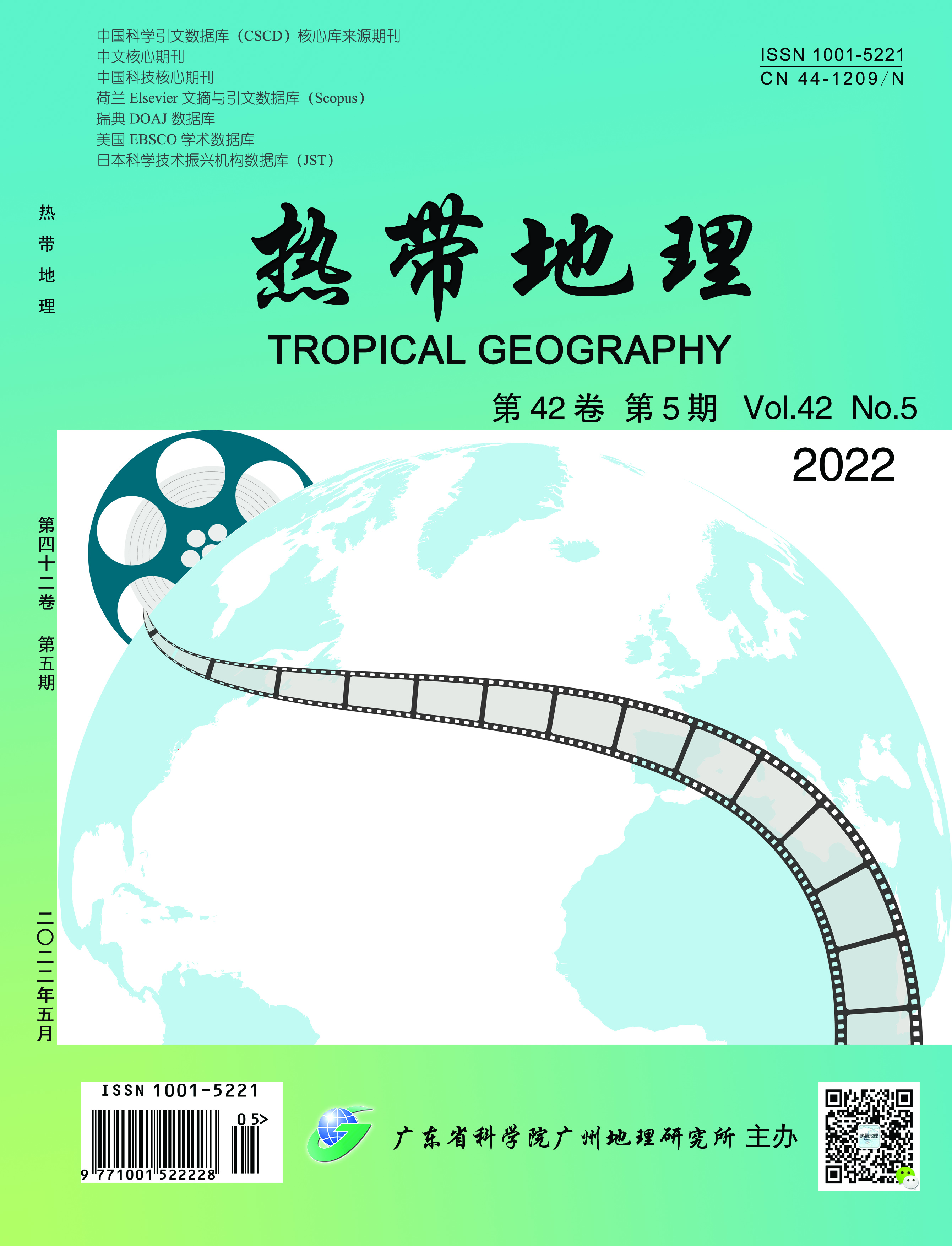
"Online movie" is a new film industry created by the Internet. The innate Internet gene of online movies makes its industrial and organizational structure more different from that of traditional theatrical movies. This study selected 305 "theatrical movies" and 1,025 "online movies" released in 2017 in China as samples and used social network analysis to compare and analyze the distribution and industrial network connections between the two types of movie enterprises from the city dimension. It also measured the impact of the Internet on the distribution of the two types of movie enterprises and industry network linkages using econometric and Quadratic Assignment Procedure (QAP) regression analysis. First, the Internet did not bring geographical endings. The spatial Gini coefficients of both types of film enterprises are above 0.9, both with a high degree of aggregation, but the spatial distribution of online movie enterprises is slightly dispersed. The reason is that the initial layout of cinema enterprises was more concentrated in the early years of the founding of China. The eight major film studios in the early years of the country were established only in a few developed cities, such as Beijing, Shanghai, Guangzhou, Xi'an, and Changchun, where the economic base was better. With the progress of information technology and the popularization of the Internet, these developed cities with the initial layout of theatrical films still have excellent Internet infrastructure conditions. In addition, such cities also have economic, cultural, social, talent and capital advantages, which continue to attract new online movie enterprises. Therefore, the Internet does not bring the end of geography at this stage. Second, compared with theatrical films, the scale and average shortest path of network connections in the online movie industry are larger, and their degree of connectivity and central potential are smaller. The Internet is changing the inter-city industrial network connections of film enterprises in the following ways: 1) the long-tail effect and convenience of consumption brought about by the Internet have expanded consumer demand for online movies, and a large amount of capital is attracted by high profits to enter the online movie industry. Therefore, compared to theatrical movies, the scale of online movie production networks is larger. 2) The labor division in the online movie industry is simplified due to the fast consumption mode brought about by the Internet, and the industrial organization structure is increasingly flat, making online movie production networks connectivity smaller, the average shortest path larger, and nodes connection looser compared with that of theatrical movie production networks. 3) The Internet's promotion of knowledge diffusion, resource flow, and technological innovation has lowered technical barriers, resource barriers, and production costs, and increased market competition in the online movie industry. Compared to the production network of theatrical movies, the central potential of the online movie production network is smaller and its power distribution is more decentralized. Third, the results of the econometric regression analysis show that cities with better Internet development have more film production enterprises, which are especially attractive to online movie enterprises. Meanwhile, the results of the QAP regression analysis show that cities with better Internet development are more likely to establish industrial network linkages, especially for "online movie" production. The results of QAP regression analysis show that cities with better Internet development are more likely to establish industrial network links, especially the labor division for "online movie" production. In addition, the regression coefficients of economic development level, openness level, geographic proximity, administrative affiliation, and industrial structure difference are all significantly positive. The contributions of this study are as follows. First, it provides a dialogue on controversial academic views. In terms of spatial distribution characteristics, although that of online movie enterprises is slightly more dispersed than that of theatrical movie enterprises, both of them have a high spatial clustering trend. This further confirms the academic view that "the Internet does not bring the end of geography at this stage." Second, it breaks through the "individual" and "isolated" enterprise perspective of previous studies as we attempted to visualize the "node" and "linkage" industrial network perspective. We also tried to analyze the impact of the Internet on the network of urban film industry from the perspective of "nodes" and "links" of industrial networks.
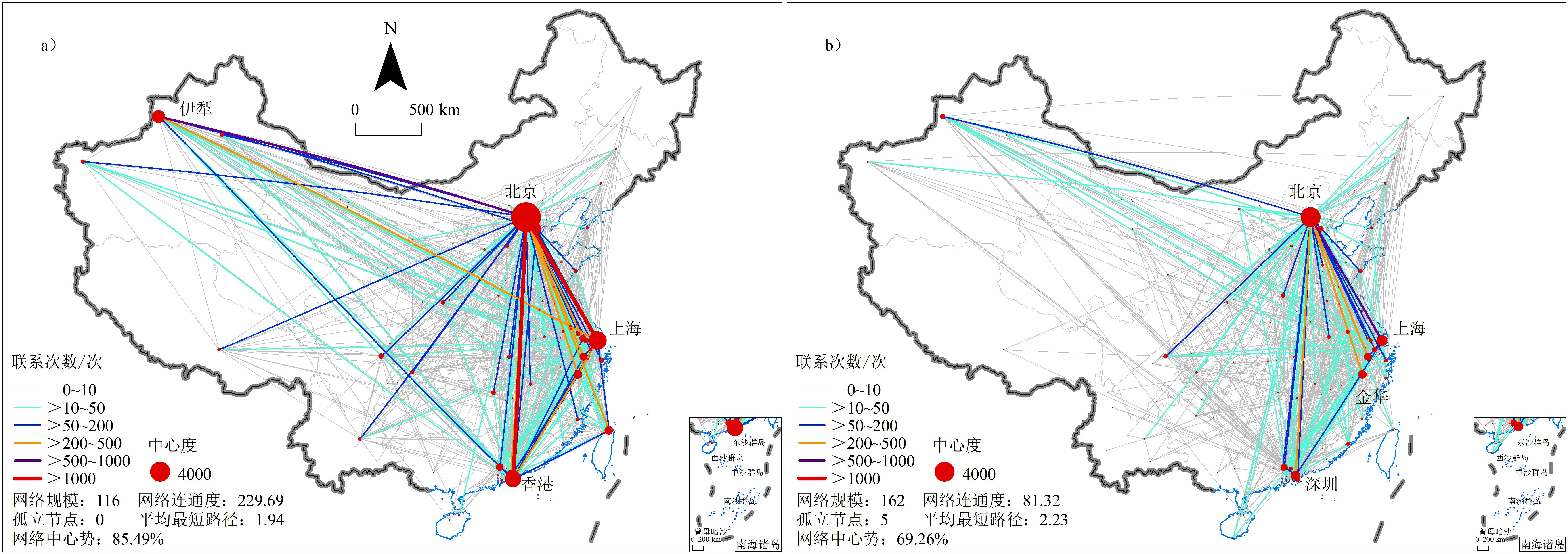
Economic geography is a subject whose research field and direction are changing. Its development track and research topics are influenced by the social development environment in which scholars live. The global economy is in a period of dramatic change, and the research perspectives and topics of economic geography have been changing particularly rapidly, with the constant emergence of new research results and new research characteristics and development trends. Therefore, it is necessary to sort out and analyze the research achievements of international economic geography and explore its development context and latest research frontiers. This paper takes 7,260 studies in the Web of Science core collection, from 1982 to 2020, as the sample literature, visualizing the intellectually-based research hotspots and frontiers of international economic geography with the help of the Citespace tool. It is expected to provide scientific reference for constructing the theory of economic geography with Chinese characteristics and promoting the international influence of Chinese economic geography. Our findings reflect the following. First, over the past 40 years, economics and economic geography have been the main knowledge sources of international economic geography. In addition, they have absorbed the research content of political economy, ecology, and other disciplines, which reflects their increasingly strong interdisciplinary nature. The intellectual base reflects changes in the economic geography research trend, basically following new regionalism, social turn, cultural turn, relational turn, and mobility turn. Since the 21st century, classical literature, under the context of relational and evolutionary economic geography, has been the main source of knowledge. Second, innovation and growth have always been the two core areas of research; hot issues such as globalization, cities, clusters, networks, the labor force, and policy have also attracted scholarly attention. Recent research points to hot keywords including resilience, global production networks, financial geography, global cities, inequality, and entrepreneurship. To some extent, these research hotspots represent the problems faced in the current stage of social development. Third, this research frontier is strongly problem-oriented, which is mainly based on the industrial development practice of western developed countries. In the era of global urbanization in the 21st century, urban issues and governance, industrial clusters, and knowledge have become research hotspots. Since 2010, the spatial evolution process of economic activities has attracted more attention, and research on its driving mechanism has been increasingly in-depth. Finally, the international economic geography research space is extremely uneven, which is closely related to the process of global social and economic development. The UK and US have always occupied a hegemonic position in the field of economic geography, even if the tentacles of mainstream economic geography begin to extend beyond Europe and America, most countries are still on the fringes of academic discussion. In general, international economic geography shows an obvious trend toward digital and sustainable transformation, and the COVID-19 pandemic has also had a certain impact on the direction of the discipline. Drawing on the international research experience, China's economic geography should strengthen theoretical innovation and put forward a theoretical system with Chinese practical characteristics, promote the cross and integration of various disciplines, and strengthen the interpretation of the geographical significance of social economic activities from the perspective of sociology.
With the accelerated pace of green technology innovation, green environmental protection has gradually become a new direction for venture capital institutions to invest. The Chinese government has issued many policies to guide venture capital and other social funds in providing financial support for green technology innovation. However, it has ignored the requirement of coordinated development between green technology innovation and venture capital. Most studies focus on the one-way relationship between venture capital and green technology innovation, but there are few studies on the interaction between the venture capital network and green technology innovation network. This study takes 27 cities in the Yangtze River Delta city cluster as an example, using the data of venture capital events and joint patent applications of green technology from 2005 to 2018 to construct a venture capital network and a green technology innovation network. It then extracts the network characteristic attributes of the node cities in the two networks to characterize the development level of the two networks in the node cities, constructs a coupling coordination degree model, and analyzes and evaluates the coupling coordination level of each network. The results show the following: (1) the development of the venture capital and green technology innovation networks tends to be gradually coordinated during the study period, and the green technology innovation network in cities with a high level of coordination has a significant influence on the development of the two networks. In cities with a high level of coordination, the contribution of the green technology innovation network to the coupled and coordinated development of the two networks lags behind that of the venture capital network at the beginning, gradually catching up and widening the gap. At the spatial scale, the level of coordinated development of both networks in the Yangtze River Delta city cluster gradually develops from a ">" pattern at the beginning to a clear "Z" pattern and shows a spatial pattern of gradual spread to inland cities. (2) There are differences in the influence of four proximity indicators on the coupled and coordinated development of the venture capital and green technology innovation networks: the economic proximity among node cities can significantly promote the coupled and coordinated development of both networks; the institutional and social proximity of node cities in the venture capital network can also play a certain driving role. However, this driving role is not obvious in the green technology innovation network, and even hinders the coupled and coordinated development of both networks. The geographical proximity of node cities has no significant effect on the coupled and coordinated development of the two networks, but there is a certain negative effect. This study presents a way of approaching the controversy of the different effects of multidimensional proximity on the coupled and coordinated development of the venture capital and green technology innovation networks and enriches research on the coupled and coordinated development of both networks. It also provides theoretical references for the coordinated development of urban venture capital and green technology innovation.
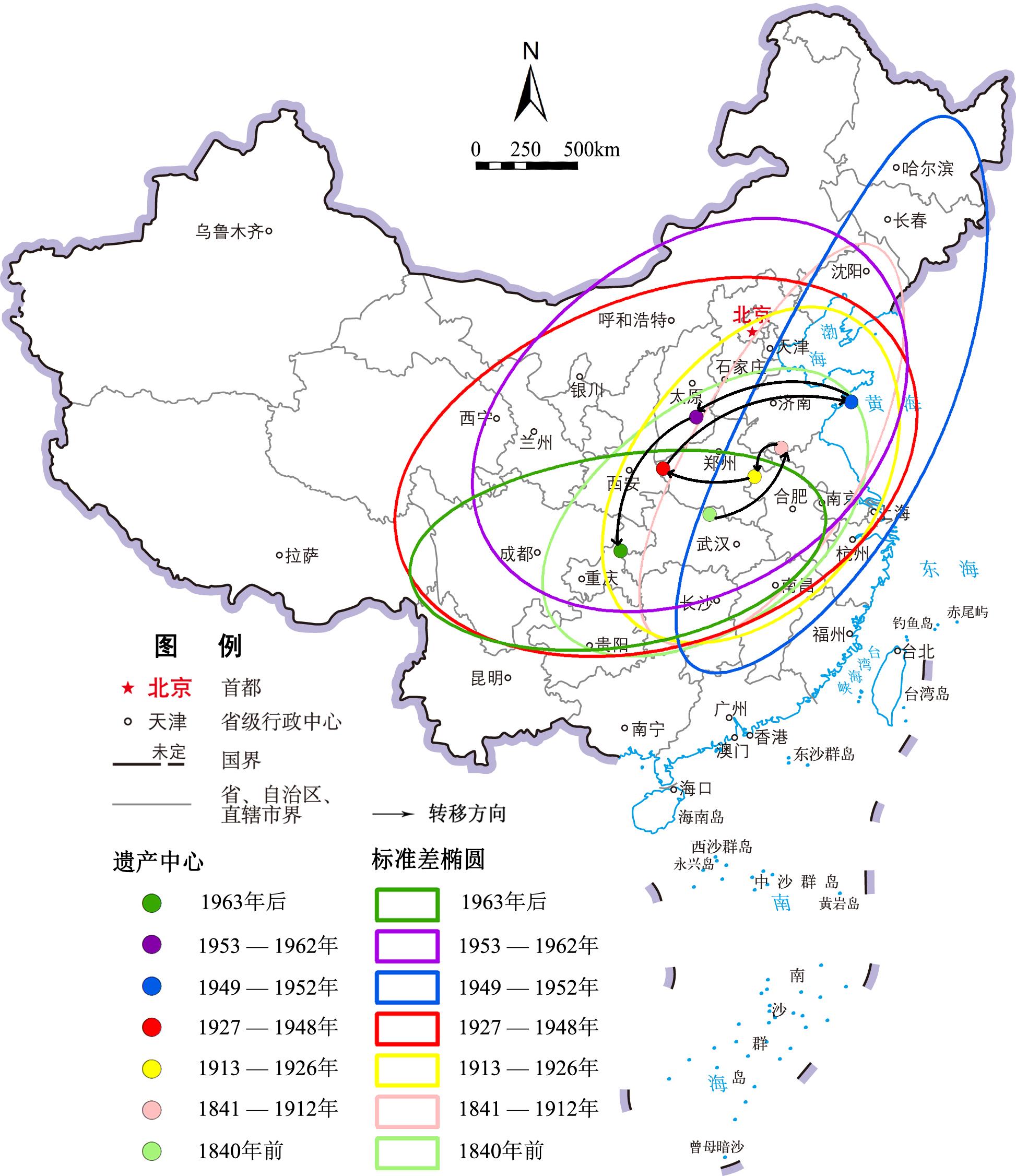
With China's entry into the era of industry and information, an increasing number of industrial enterprises have withdrawn from the historical stage owing to technical bottlenecks, environmental pollution, and lack of resources. The Party and Government attach great importance to the protection, utilization, and research of industrial heritage. This study takes 164 national industrial heritage groups since 2020 published by the Ministry of Industry and Information as the research object. This paper discusses the spatial and temporal distribution characteristics of national industrial heritage and analyzes its influencing factors using the spatial analysis methods of nuclear density and concentration trend evolution of the geographic information system platform. The main results of this study are as follows: 1) The spatial distribution of national industrial heritage shows remarkable positive spatial autocorrelation, and this correlation increases over time; There are more industrial heritages in the southeast and less in the northwest, and the spatial pattern of "three cores, two pairs, sheet distribution" is formed. 2) From the perspective of heritage types, light industry is mainly distributed in the Yangtze River Basin and coastal areas, while heavy industry is more dispersed. 3) The distribution of industrial heritage in the province is unbalanced, with three types of areas. Type I is in the northeast and first-tier areas, such as the southeast coastal areas in China. Type II is in third-class areas like northwest China, while the others are type III. 4) From the perspective of time evolution, the spatial distribution center of industrial heritage has four obvious turns. Before the founding of New China, the span of the Heritage Center in different periods was small, and the span became larger after that. 5) Most industries in ancient China were influenced by natural geography and the socioeconomic environment. Although the industries in modern China were influenced by the above factors, they were more influenced by historical and political factors such as nationalism, the Westernization Movement, and major national strategies. National industrial heritage is concentrated in the southeast coastal and middle and lower reaches of Yangtze River plain areas with good natural environment, high population density, high economic level and smooth information flow, while the number of distributions in Guangdong and northwestern areas is less, and areas such as Guangxi and Ningxia are even blank. On the one hand, due to the backward industrial development of Inner Mongolia, Xinjiang, Tibet, and other provinces in the western region, only a few meet the requirements for the selection of national industrial heritage. On the other hand, "Renewal" has become the theme of the development and planning of times in the process of rapid urbanization in Guangdong Province, one of the birthplaces of modern industry in southern China. A large number of industrial heritage sites have been abandoned and demolished, and the protection and development of these sites are far backward. Therefore, each province should fully understand the importance of protecting and selecting national industrial heritage and take this as an opportunity to accelerate this process within their respective jurisdictions. Each province ought to reasonably link development and protection to better promote the organic renewal and activation of cities.
"Place identity" is an important concept that measures personal place emotion and reflects the complicated dynamic relationship between personal identity and one's local environment. Enterprise communities (ECs) are a major type of gated, walled-off residential spaces. They were built and managed mostly by the state or collectively owned enterprises during the planning economy period, and many are still employed in urban China. Understanding the place identity of EC residents is of great significance for community renewal, neighborhood revitalization, and sustainable urban development. Using the Northwestern First Printing and Dyeing Factory community as a typical example, this paper uncovers the changes and mechanisms of personal place identity under the influence of social environment changes and community transformation using grounded theory, while discussing its policy implications. The main results are as follows: first, 13 open coding items, such as cognitive change of identity, reduced familiarity, weakened social interaction, and dilapidated housing construction were defined; further, four axial codings, including personal identity changes, emotional memory changes, identity change in social life, and physical environment identity, were set, and an analysis framework on the change of residents' place identity in the ECs (selective coding) was built. Second, the residents' personal awareness in ECs has changed from Danwei people in the era of planned economy to social people in the market economy period and to left-behind elderly groups in the future. Third, inherited collective memory maintains the residents' positive place identity. Alienation of social interaction and socialization of community management weaken place identity. The dilapidated material environment and backward support facilities cause the residents to experience negative identity. Fourth, residents build their own and local identity in the interaction between the EC environment and society that accompanies their life and growth, and the identity changes along with the variation of external social environment and internal individual characteristics. External factors such as state-owned enterprise reform and housing policies have led to enterprise transitions and changes in social space in the ECs, affecting residents' emotional experience and identity. Internal factors such as length of residence, individual characteristics, psychological factors, and individual experiences all have an effect on identity. These jointly shape the residents' place identity and can alter its processes. Finally, this work is helpful in providing insight into socialist work-unit communities for Chinese transformation and renewal, deepens the understanding of traditional residential space succession theory arising from residential suburbanization, residential segregation, inner-city renewal, gentrification, and polarization of living space, enriches the case types of place identity theory in view of the unique value and function of the ECs, and provides a reference to carry out the renewal of old communities more successfully.
Although it is widely acknowledged that urban expansion is one of the most important processes affecting global sustainable development, an increasing number of cities are shrinking across the world. There is growing interest in urban shrinkage because it has reached a global scale, decisively affecting the fate of many cities over the past half-century. In recent years, urban shrinkage has become a big challenge for China's new-type urbanization construction and sustainable development due to slower economic growth, rapid aging, and massive migration. Although research on urban shrinkage has rapidly increased in recent years, many theoretical and methodological issues must be further discussed, such as the identification of shrinking cities from multiple dimensions and the dynamic process of urban shrinkage. Therefore, this paper proposes a new, multi-dimensional analysis framework from the following aspects of urban shrinkage: types of shrinking dimensions, number of shrinking dimensions, and temporal evolution. Subsequently, this framework was employed to explore the spatial-temporal evolution characteristics of shrinking cities in China by means of GIS spatial analysis and grey relational analysis. The results indicate the following: 1) this new framework presents satisfactory flexibility and higher adaptability, and it helps to enhance the comparability of shrinking city studies. Furthermore, it has considerable potential in promoting the construction of a multi-dimensional typology for shrinking cities and analyzing the possible temporal evolution paths of urban shrinkage. 2) In the four periods of 1995-2000, 2000-2005, 2005-2010 and 2010-2015, the proportion of population shrinking cities accounted for 9.55%, 20.34%, 15.34% and 19.72% of the total cities in China respectively; while the proportion of economic shrinking cities were 5.32%, 4.85%, 0.47% and 8.29%, and the proportion of space shrinking cities were 7.04%, 3.44%, 3.76% and 1.72% respectively. Population shrinkage is the main characteristic of urban shrinkage in China. From the perspective of spatial distribution, population shrinkage is a national phenomenon because such cities are distributed in various regions in China. As for temporal evolution, the proportion of population-shrinking cities in Western and Northeast China, with relatively lagging economic development, increased significantly. 3) The extent of urban shrinkage in China is not very serious because the population shrinkage rates of the majority of shrinking cities were less than 3%, and only two continuous population-shrinking cities have been identified: Yakeshi (Inner Mongolia) and Qidong (Jiangsu Province). Furthermore, no continuous economic- or space-shrinking city exists in China. 4) Three interesting paradoxes were revealed regarding urban shrinkage in China: the built-up areas in 93.03% population-shrinking cities were expanded, the gross domestic product (GDP) of 92.37% population-shrinking cities were increased, and the built-up areas of 94.57% economic-shrinking cities were expanded. The emergence of the above paradox has a strong relationship with China's factor-dependent economic growth model and local governments' land financing model.
Manufacturing is an important engine of China's economy, driving urban economic growth and spatial transformation. Therefore, the spatial evolution of manufacturing is a research hotspot for academics. This study takes the Changsha metropolitan area as an example, based on the micro-data on manufacturing enterprises from 1978 to 2020. Using the standard deviational ellipse, kernel density analysis method, and explored negative binomial regression model, the spatial evolution characteristics and influencing factors of the manufacturing industry in the Changsha metropolitan area from the point-and-surface perspective are explored. The main conclusions are as follows. From 1978 to 2020, the number of manufacturing enterprises in the Changsha metropolitan area show an overall increasing trend, with labor-intensive and capital-intensive manufacturing gradually upgrading to a technology-intensive form. In terms of spatial distribution, all manufacturing industries show an apparent movement of suburbanization in spatial distribution. Development zones are progressively becoming the primary spatial carrier for manufacturing reorganization and concentration. The manufacturing industry mainly expands along the "northwest-southeast" direction, showing a "point-axis" development pattern. In the process of spatial evolution, the Changsha manufacturing space has experienced a cyclical change from agglomeration to dispersion and then to accumulation. The evolution pattern has changed from mosaic filling to outward diffusion. Influenced by the characteristics of the industry, different types of manufacturing industries show apparent differences in spatial distribution. Labor-intensive enterprises are mostly micro-enterprises with flexible site layout, mainly contact diffusion and hierarchical diffusion, and the spatial characteristics of "central concentration and decentralized layout." The large-scale demand for land and employees in capital-intensive manufacturing industries-mainly large enterprises-restricts their concentration in urban centers. Meanwhile, preferential policies, such as "policy rent" in the development parks in peripheral suburbs, attract enterprises to move in, prompting capital-intensive manufacturing industries to show the spatial characteristics of "large-scale diffusion and small-scale concentration." Technology-intensive manufacturing industries are mostly small and medium-sized enterprises, which are attracted by national development zones and have strong vocational orientations. In the spatial evolution process of the manufacturing industry, factors such as socioeconomics, production cost, and governmental behavior have significant influence. Different factors play different roles in different industries. Labor-intensive enterprises are mainly affected by socioeconomics, production costs, and government behavior. Technology-intensive enterprises pay more attention to regional economic benefits, innovation environment, and policy support, while socio-economic factors, production cost, built-up environment, governmental actions, and innovation capacity all have important impacts on them. Capital-intensive enterprises are highlighted by the role of the population base, transportation accessibility, land cost, and industrial park policies. Capital-intensive enterprises are highly dependent on population, production cost, transportation accessibility, and the number of industrial zones. It can be found that the spatial evolution of all three types of manufacturing industries is significantly influenced by governmental actions; among which, the level of fixed asset investment and number of industrial parks reflect the planning guidance and policy orientation of Changsha's municipal government on manufacturing development. In addition, the degree of opening up to the outside world negatively affects the layout of all three types of manufacturing enterprises, indicating that the large influx of foreign capital tends to form industrial monopolies. This study provides a reference for optimizing the layout and high-quality development of urban manufacturing space.
With the advancement of new urbanization and territorial and spatial planning, the scientific development and governance of peri-urbanization areas have become an important link in the development of urban-rural integration. This study identifies the research hotspots and evolving process in this field and discusses the existing deficiencies and future development trends in current research, aiming to provide a reference for the development of peri-urbanization areas in China. Based on the bibliometric analysis method and using the visualization tools of CiteSpace and VOSviewer, a knowledge map analysis of domestic peri-urbanization research results over the past 30 years was conducted from the aspects of research strength, research hotspots, research topics, and evolutionary context, among others. The results show the following. 1) The research strength of the authors and institutions is scattered, the geographical distribution characteristics are obvious, and the research ability is positively correlated with the level of social and economic development. 2) Research hotspots focused on developed cities such as Beijing, Guangzhou, and Shanghai in the early stages, later expanding to central and western cities or urban agglomerations such as Wuhan, Chengdu, Chongqing, and Zhengzhou. Land use research, landscape pattern analysis, landless peasant research, and analysis of their influencing factors are the research hotspots; their respective themes can be clustered into four categories: morphological characteristics, spatial definition, driving mechanism, and coordinated development. 3) The development of peri-urbanization research can be divided into three stages: the rising stage (1992-2002), rapid growth stage (2003-2014), and stable development stage (2015-2019). The research area has shifted from the southeast coast to the inland areas, the research content has transformed from qualitative theoretical analysis to quantitative empirical discussion, and the research data have changed from traditional social and economic statistical data to spatial data and network open data. The research perspective has also changed from an analysis of natural characteristics to research on social development, reflecting more humanistic care. However, in terms of research subjects, the cooperation between authors and institutions is limited by groups and regions, and the intensity of cooperation needs to be strengthened. Regarding research content, the theoretical framework and research paradigm of peri-urbanization research are not sufficiently clear, especially in terms of conceptual connotation and space definition standards, concerning which there is still no unified approach. Regarding research perspective, the transitional path of peri-urbanization, population urbanization, ecological environment protection, construction of human settlements, and other issues should also be deeply analyzed. Finally, the prospects are constructed from four aspects: multi-scale dynamic monitoring of the spatial scope of the peri-urbanization area, creating a green and livable living environment, exploring the path of agricultural transfer population urbanization, and implementing the equalization of basic public services. The aim is to provide practical guidance for population management, resource allocation, and policy formulation in the peri-urbanization area.
Driven by the rapid development of tourism, human settlement space in tourism destinations is facing an unprecedented multifunctional transformation. Multifunctional theory provides a new theory and paradigm for research on the sustainable development of human settlements and provides creative solutions for the construction and regulation of human settlements in tourism destinations under the typical regional environment of China. This study systematically analyzes and summarizes the concept evolution, evaluation system, changing characteristics, driving mechanism, and adaptive regulation of multifunctional human settlements in tourism destinations at home and abroad. The study reveals the evolution path of current research and offers future research directions and suggestions. The main conclusions are described as follows: 1) Regarding concept connotation and evaluation system, more research focuses on the diversified needs of high-quality human settlements. 2) Regarding spatial changing characteristics, more research presents a transformation from the overall description of macro region, focusing analysis on villages and towns in mesoscale, to the in-depth exploration of interior space for residences on a micro scale. 3) In exploring the driving mechanism, more studies combine natural factors and social factors to explore driving forces. The current research results show the characteristics of a "natural resource base determining the spatial function type" in the initial stage, to "industrial development leading the spatial function transformation" in the mid-term stage, and "the pursuit of natural comfort in human settlements" in the later stage. 4) In terms of adaptive regulation, most studies conclude to countermeasures that mainly realized through the coordination of stakeholders' social relations and the optimization of the combination and utilization development of physical space. Finally, this study establishes the evolution path map of the three stages of multi-functional human settlement in tourism destinations, and offers a focus for follow-up research, including evaluation systems combined with humanism, a more comprehensive coupling and trade-off driving mechanism within stakeholders on the multi-level spatial scale, and a multifunctional transition optimization strategy combining top-down and bottom-up approaches. Meanwhile, it is emphasized that the integration and innovation of interdisciplinary methods will become an important breakthrough.
Extant studies examining the process of population migration in China are mostly based on the two front and back nodes of first-time migration and the final settlement (or return). However, less attention has been paid to the subsequent flow of the population and the overall flow process of multi-stage migration, which has caused problems. There are significant gaps in the understanding of the multi-stage process of population migration and flow in China, which also affect the expansion and deepening of the spatial pattern and law of population migration. Considering the above, this article is supported by the 2017 China Mobile Population Dynamic Monitoring Survey data; it used descriptive statistics and community discovery methods comprehensively to analyze the first-time migration of the floating population and the current-time migration between cities of different regions and scales and levels, as well as spaces between different cities. Thus, a comparative study on the spatial differentiation characteristics revealed the inherent laws of similarities and differences. The results show that (1) regarding regional differences, the pattern of outflows remains relatively stable in the two phases of mobility, while the changes in the pattern of inflows are mainly reflected in the decrease in the proportion of inflows to the central region and the increase in the proportion of inflows to the western region in the current-time migration. The proportion of inflows to megacities decreases significantly, while the proportion of inflows to Type I megacities, medium-sized cities, and Type I small cities increases; furthermore, the proportion of inflows to municipalities directly under the central government and municipalities with separate plans increases, and the proportion of people moving to sub-provincial and provincial capitals decreases. (2) The net migration pattern between cities and municipalities is stable, with net in-migration distributed in "blocks" in developed cities in the eastern coastal provinces and in "dots" in central and western provincial capitals and some resource-based and port cities, while net out-migration is distributed in blocks. Net in-migration is distributed in blocks in most cities in the central and western regions and inland cities in the coastal provinces, whereas net out-migration is distributed in blocks in most cities in the central and western regions. (3) The two stages of migration are dominated by the intertwined patterns of migration in the vicinity and long-distance migration, and the pattern of migration networks between cities and regions is thus characterized by the phenomenon of "dense east and sparse west," with the Hu Line being the boundary. However, there is also a decrease in the size of migration to Beijing, Tianjin, and Hebei at the current-time migration stage of mobility, with the Yangtze River Delta replacing the Pearl River Delta as the preferred inflow region. (4) The livelihood strategies and spatial inertia of the mobile population are the main reasons for their similar spatial patterns in the first-time and current-time migration stages of mobility. The transformation and upgrading of the industrial structure and the gradient transfer between regions are important forces that lead to changes in the destination choices of the floating population. The main contribution of this study is an innovative comparative analysis and a description of the spatial pattern of the first-time and current-time migration of the floating population. Furthermore, it provides a feasible observation perspective for the cognition of the spatial characteristics and evolution rules of the multi-stage flows of the floating population.
The citrus orchard landscape in Jeju Island, South Korea has important cultural heritage value. It is a unique agricultural landscape shaped by local people, using the special climate, hydrology, and vegetation environment of Jeju Island. The Joseon Dynasty in the 16th century established a tribute system for citrus. The Jeju government also set up a citrus garden. Since then, the regional distribution and geographic landscape of citrus groves on Jeju Island have experienced great changes. This paper combines natural factors, such as climate and water resources, with human factors, such as Korean citrus industry policies, the market, social changes, and technological progress to study the changes in the landscape and spatial distribution of citrus orchards in Jeju Island since the 15th century, and analyzes the driving forces behind the spatial changes in citrus production on Jeju Island. The results show the following. From the 16th century to 2019, citrus production on Jeju Island experienced development-historically significant ups and downs of decline and strong revival. A large migration of production space from north to south was found. The space for citrus production has expanded gradually, and the production of citrus orchards on Jeju Island has undergone a transformation from government orchards in the Joseon period to a modern experiential farm for tourism. The driving forces for citrus production space changes and geographic landscape changes are complex. Water resources were the main natural factor affecting the distribution of citrus groves during the Joseon Dynasty. The social system, transportation, and market were the main factors influencing the expansion of citrus orchard production space from the 16th century to modern times. During the development of and changes in citrus production space over the past five hundred years, human factors have continuously strengthened and influenced the optimization and adjustment of citrus space and the geographical landscape. Since the 1970s, advances in water resource development technology have changed the spatial distribution pattern of modern citrus orchards. Research on the long-term production space and geographic landscape changes in Jeju Island, and their mechanism of citrus orchards, can create a cultural landscape of citrus orchards with local characteristics for traditional citrus cultivation areas in China. It can also provides references for folk customs, cultural products, and the upgrading and development of China's citrus industry.
Accurate information on the spatial distribution of water is of great significance for monitoring water resources and applications, urban planning, and social and economic development. Remote sensing image segmentation technology based on convolutional neural networks has become an important approach for extracting the spatial distribution of water from remote sensing images. When only convolutional neural networks are used to extract spatial distributions of water from remote sensing images, there are often large differences between the features of edge and internal pixels of water objects, resulting in high noise, fuzzy boundaries, and large differences in the accuracy of extraction of internal and edge pixels. Improving the precision of edge pixel segmentation is the key to improving the precision of the whole extraction result. In this paper, the edge extraction algorithm is used to generate edge images from original images, and remote sensing images and edge images are taken as inputs to establish a water extraction model of high resolution based on semantic feature and edge feature fusion. A semantic and edge feature fusion network, SEF-NET (Semantic Feature and Edge Feature Fusion Network), is used to extract water objects from high-resolution remote sensing images. SEF-NET consists of an encoder, a multi-parallel cavity convolution module, a decoder, and a classifier. The encoder contains a group of semantic feature extraction units and a group of edge feature extraction units, and each group of feature extraction units can extract 4-level features. The multi-parallel cavity convolution module is composed of four extended convolution layers of different cavity sizes in series, which can obtain feature maps at four scales and add them together with the initial input feature maps to obtain multi-scale semantic feature maps. A 4-level decoding unit is set up for the decoder, which splices semantic feature images and edge feature images in series, and then performs feature fusion and upsampling. This strategy can reduce the feature difference between the edge pixel and the inner pixel of the object to obtain high inter-class discrimination and intra-class consistency. SoftMax was used as a classifier to complete pixel classification and generate the final segmentation results. In this paper, the Gaofen Image Dataset, the high-resolution visible light image water object dataset of the 2020 "Xingtucup" High-resolution Remote Sensing Image Interpretation Software Competition, and eight Gaofen-2 images from 2020 were selected for comparative experiments to extract water. SegNet, DeepLabV3, Refinenet and HED-H CNN were the comparison models. The recall rates (91.97%, 92.07%, 93.97%), accuracy rates (91.12%, 98.37%, 97.88%), precision rates (89.56%, 95.07%, 94.06%) and F1 scores (91.54%, 95.12%, 95.88%) were better than those in the comparison models, indicating that the SEF-NET model had greater accuracy and generalization ability in extracting water from high-resolution remote sensing images. Thus, the SEF-NET model served government decision-making and monitoring water pollution better than the comparison models did.