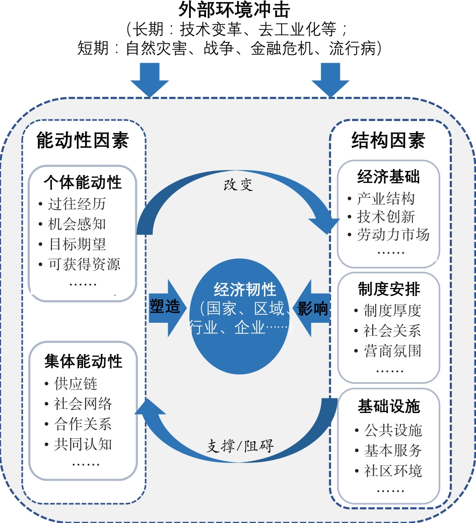
The novel coronavirus disease 2019 (COVID-19), which spread all over the world at the beginning of 2020, exerted significant impacts on the substantial economic and social development in China, seriously affecting the production and operation of Chinese small and medium-sized enterprises (SMEs). As the COVID-19 pandemic was effectively controlled by the central government, China's economy manifested strong economic resilience during the process of recovery. Under these circumstances, it provided a valuable opportunity to examine the dynamic evolution and mechanism of economic resilience over a relatively short period. In economic geography research, structure and agency are the two main influencing factors for regional economic resilience; specifically, structural factors refer to the economic diversity and inherited structure of a regional economy in building resilience capacities, while agency factors focus on the role of agentsin a resilient economic system. However, the existing literature has focused heavily on structural factors, but the effect of agency factors has gained less attention. Based on interviews with 43 manufacturing SMEs in Dongguan in 2020, this study 1) investigates the dynamic evolution and characteristics of short-term economic resilience from an agency perspective and 2) demonstrates the micro-mechanism of reconstructing economic resilience at the enterprise level by constructing a structure-agency framework. The study derives several findings. First, economic resilience is not an inherent attribute of an economic agent. In the short term, the formation of economic resilience can be divided into a three stage process from cognition to adaptation, and then to reconstruction. Each stage manifests different agency characteristics. Second, the reconstruction of economic resilience is strongly influenced by the individual (entrepreneurs) and collective agency (supplies and customers) in the COVID-19 shock. For individual agencies, manufacturing SMEs are sensitive to perceiving and seizing the "opportunity space," which is technologically related to their primary products. For collective agency, many entrepreneurs actively offer financial support to their upper and lower reach enterprises to enhance economic resilience by forming collective networks. Third, structural factors (i.e., industrial structure, institutional arrangement, and infrastructure construction) also influence the formation of economic resilience in a short period. In the case of Dongguan, industrial structure and institutional arrangements contributed to enterprises' return to normal production during the COVID-19 crisis, while the imbalance of infrastructure structures (including basic social and public services) plays a constrained role in economic resilience. Moreover, three theoretical implications are proposed: emphasizing the transformation between short-term adaptation and long-term adaptability, concerning the shaping of structural factors caused by agency, and paying attention to the coupling between agents and external connections.
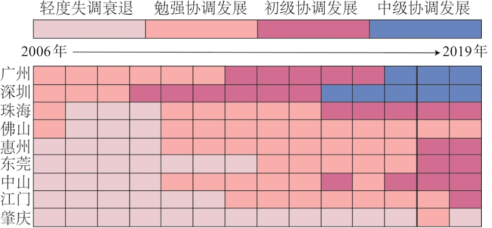
As economic globalization deepens, academic attention has shifted from the pattern and spatial organization of global production to the important participants of globalization: workers. Existing studies pay much attention to the added value and profits from economic upgrading in the process of globalization. Few works examine the improvement of workers' employment quality and social participation level brought about by social upgrading. In particular, there is a shortage of research on the relationship between economic upgrading and social upgrading. To further explore the relationship and synchronous process between these two and provide policy implications to help promote the type of upgrading that benefits the majority of workers rather than a small number of enterprise owners, this study adopts the entropy value method to comprehensively compare the characteristics of economic and social upgrading in the Pearl River Delta (PRD) region in South China from 2006 to 2019. It uses the improved coupling coordination model to quantitatively measure the coupling degree and coupling coordination degree of economic and social upgrading, and analyzes the factors affecting the coupling coordination degree based on several panel data regression models. The results are as follows. First, the process of economic and social upgrading in the PRD from 2006 to 2019 shows a fluctuating upward trend overall. The global financial crisis and the local industrial transformation in the region are important factors affecting the process of economic and social upgrading. Second, the overall coupling degree of the economic and social upgrading in the PRD during 2006-2019 shows a U-shaped evolution, changing from a high-level coupling stage down to a running-in stage and then up to a high-level coupling stage. Third, from 2006 to 2019, the coupling coordination degree in the PRD shows an overall increasing trend. This period saw improved coordination between the economic upgrading system and the social upgrading system. Finally, the level of regional human capital, consumption demands, foreign investment, and public governance have positive effects on the degree of the coupling coordination of economic and social upgrading in the PRD, while environmental pollution has a negative effect. This study contributes to the existing literature on social upgrading by integrating economic and social upgrading into the framework of regional development and revealing the coupling and coordination relationship between economic and social upgrading. The results advance our understanding of the relationship between economic and social upgrading and explores the policy implications for promoting regional economic and social development. Enhancing workers' human capital, increasing consumption demands, attracting global capital, and strengthening public governance are likely to stimulate the role of economic upgrading in promoting social upgrading.
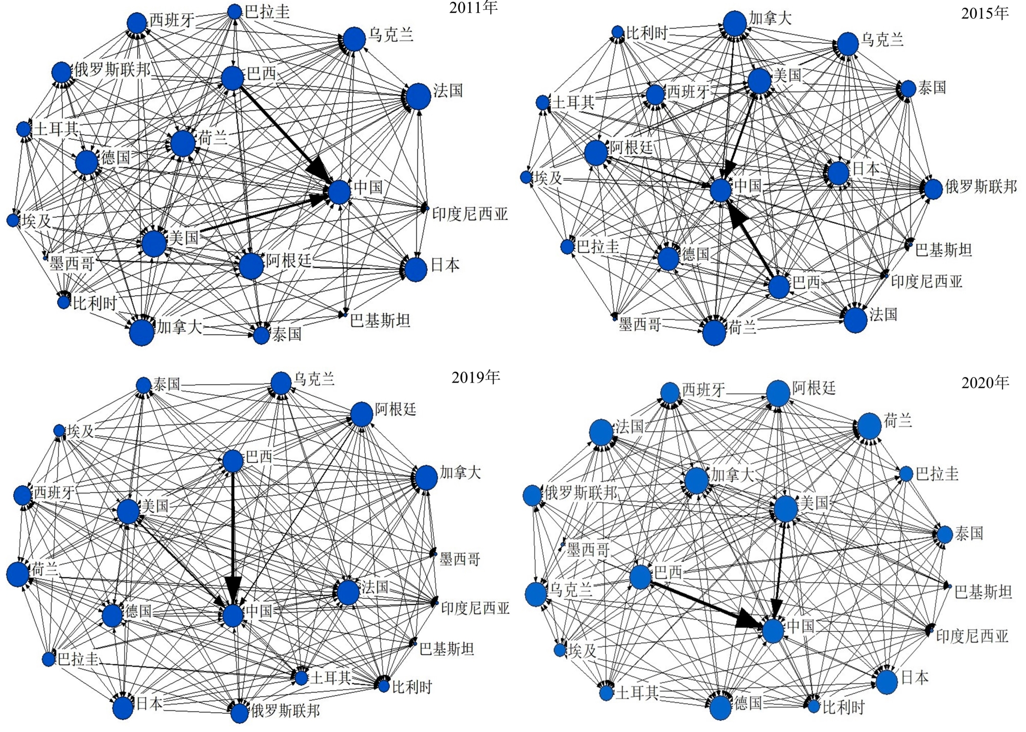
Based on the data on international oil-bearing crop trade published by UN Comtrade from 2011 to 2020, this study adopted the complex network analysis method to investigate the evolution characteristics of the world oil crop trade network and explored the influence factor of the oil crop trade network through the Quadratic Assignment Procedure model. The results indicate that the oil trade network has good connectivity and small world attributes, but the overall network density and reciprocity coefficient are relatively low, and the links between the nodes in the network need to be strengthened. The international oil crop export market is highly concentrated, and the import market is relatively scattered. Brazil's oil crop exports have gradually increased, eroding the market share of the United States and shifting the trade focus to developing economies led by Brazil. The oil crop trade network has a "core- marginal" circle structure. The United States, Brazil, and Argentina are the main core countries, displaying a "tripartite" trend in oil crop trade and having a strong influence on other countries. Economic scale difference, difference in per capita income, per capita cultivated land area difference, and land bordering have a significant positive impact, and institutional distance has a significant negative impact on the unauthorized network and weighted trade network of oil crop trade. There is a negative correlation between the difference in the labor force and the growth of trade volume, and the degree of impact is gradually weakened. Geographical distance has an opposite effect on oil crop trade relations and trade flows. It is negatively correlated with the oil crop trade in the unauthorized network, but positively correlated with the weighted network. China is a major importer and consumer of oil crops, and the import trade has developed rapidly. However, the import sources are excessively concentrated, the import potential risk is large, the position in the trade network is not high, the closeness and betweenness centrality indicators rank low, and its influence on the international oil market does not match its position as a major trading country. In this regard, China should adjust the country structure of oil crop imports, build a supply network, deepen trade cooperation and interest convergence, and ensure the safety of oil crop imports.
Scholars have widely discussed the topic of regional spatial structure. However, most of the literatures are produced to understand this filed from a single scale perspective, with little attention to multi-scale perspectives and the relationship between different scale areas.In addition, the current empirical results are mostly concentrated in the eastern coastal areas of China, and few studies examine the underdeveloped southwest regions. This study goes beyond the method of taking prefecture-level cities as measurement units and investigates the relationship between different scales in the field of urban networks. Based on mobile signaling data, this study conducts an empirical examination of the spatial network structure of Guangxi, where urban districts and counties are taken as basic measurement units, and the connection degree and centrality models are employed for quantitative analysis. The following results were derived: In terms of horizontal linkage, the relationship between four sub-regions shows that southern Guangxi has the highest centrality, followed by western Guangxi and northern Guangxi, eastern Guangxi has the lowest centrality. The connection degree of four sub-regions indicates that southern Guangxi has the strongest connection with western Guangxi, as well as strong connections with eastern and northern Guangxi. Northern Guangxi has weak connections with eastern and western Guangxi, while eastern Guangxi has the weakest connection with western Guangxi. The relationship between inter-prefecture-level cities shows that Nanning has the highest centrality, followed by Laibin. The connection among prefecture-level cities is centered on Nanning, and there are two main connection axes: Nanning-Hechi and Nanning-Laibin. The relationship between inter-urban districts shows that Guilin has the highest centrality, followed by Liuzhou and Yulin. Hechi has the lowest centrality, and there are five prominent connections: Fangchenggang-Qinzhou, Guigang-Laibin, Qinzhou-Nanning, Laibin-Liuzhou, and Chongzuo-Nanning. The inter-county relationship shows that the relation intensity is relatively lower; Guiping has the strongest connection with Pingnan, followed by Lingshan-Pubei. Strong connections are mainly located in the Beibu Gulf urban agglomeration, the Xijiang Economic Belt, along National Highway 324, and around the Lijiang River Scenic Area in Guilin. In terms of vertical linkage, the inter-city relationships within four sub-regions show that the internal connection of northern Guangxi is the strongest, followed by eastern and southern Guangxi, and that of western Guangxi is the weakest among four sub-regions, which can be used as the basis of economic zone division. The relationship between urban districts and counties shows that administrative jurisdiction has an important influence on the connections between these. The relationship intensity conforms to the law of distance attenuation, but some connections are beyond the scope of administrative jurisdiction. The hinterland of each urban district can be divided into three patterns: cross-, weak, and suitable boundaries. Nanning and Liuzhou are cross-boundary patterns, Hechi is a weak boundary pattern, and the rest are suitable boundary patterns. Comparing this with the current administrative regions, there are obvious differences; Nanning and Liuzhou have a wider scope of influence than their administrative regions, and Hechi has a smaller scope, which provides a basis for further adjustment of the administrative divisions.
New urbanization promotes the free flow and redistribution of tourism elements in space and accelerates the transformation of the tourism economy to intensive and efficient development, which is one of the possible ways to optimize tourism efficiency. Taking 30 provinces in China as case studies, this study utilized the entropy method and bootstrap-data envelopment analysis to measure the level of new urbanization and tourism efficiency from 2001 to 2019. A bivariate LISA model was adopted to investigate their spatial correlation characteristics. Spatial Durbin and threshold models were used to analyze the spatial effect and dynamic non-linear impact of the development of new urbanization on tourism efficiency. The results revealed the following: 1) During the study period, the level of new urbanization and tourism efficiency in China showed varying degrees of fluctuation and improvement, with the largest increase in the Central and Western areas. Spatial differentiation characteristics were in the order of Eastern Area > Central Area > Western Area > Northeastern Area and Central Area > Eastern Area > Western Area > Northeastern Area. 2) A positive spatial correlation was observed between new urbanization and tourism efficiency. Local spatial correlation types of spatial agglomeration were namely H-H and L-L. A total of two new urbanization areas had a spatial effect on tourism efficiency. The direct and indirect effect coefficients were 0.274 3 and -0.634 5, respectively. New urbanization in this region was found to have a positive effect on the improvement of tourism efficiency, while the improvement of new urbanization in adjacent areas is expected to inhibit the improvement of tourism efficiency in this region. 3) Under the influence of the threshold variable of tourism industry status, the positive effect of new urbanization on tourism efficiency exhibited a double threshold, showing a U-shaped change trend of "decline first and then rise." Based on the results, this study proposes differentiated countermeasures to improve regional tourism efficiency, expands the research on the non-linear relationship between new urbanization and tourism economics from the perspective of comprehensive development of new urbanization, and enhances the academic attention on the feedback effect of new urbanization on tourism economy.
From the perspective of individual psychological decision-making, drawing on data from the 2016 "Migrants' Dynamic Monitoring Survey" and case interview data, using mixed research method of quantitative research and qualitative research, this paper analyzes the influence mechanism of "home" and "employment and entrepreneurship" in the outflow area to young migrant workers' return migration intention. It is found that "home" in the cultural sense is a deep factor affecting return migration intention of young migrant workers, but its influence needs to be strengthened by "employment and entrepreneurship". They work together to generate return migration intention of young migrant workers. The cultural concept of "home" triggers the return of young migrant workers through new life nodes, challenging family responsibilities and planned family development. While the imagination of "employment and entrepreneurship" strengthens return migration intention by choosing new employment places, longing for good employment conditions, looking for unique entrepreneurial resources and changing the old development path. Thus some young migrant workers in the outflow place can have both"home" and "employment and entrepreneurship"at the same time. In the current situation of unbalanced and insufficient development among regions in China, the governments in the central and western region should not only vigorously develop the economy, increase employment opportunities and improve the income level, but also increase the entrepreneurial support for returned young migrant workers, so that the "employment and entrepreneurship" of returned young migrant workers can be continuously strengthened, and they can continue to have both"home" and "employment and entrepreneurship". This paper have expanded the depth and breadth of the analysis of the return migration problem of young migrant workers, and promoted the development of relevant fields. Its contributions are as follows: first, based on the perspective of individual psychological decision-making, through in-depth observation and description, it presents the generation process and mechanism of young migrant workers' return migration intention in a more detailed and comprehensive way. Second, by examining the mechanism of both"home" and "employment and entrepreneurship" affecting the return migration intention of young migrant workers, it finds that some returned young migrant workers can have both "home" and "employment and entrepreneurship". Third, this paper takes "home" in the cultural sense as a method to analyze the return migration intention in China, which is different from the understanding of "home" in foreign Critical Geography. In the study of migrant workers, we can take "home" as a key entry point, and build an analytical framework of Chinese discourse from "home", which contains the possibility of creating a theory of Chinese local population mobile.
The mismatch between the supply and demand of community-service-oriented home care facilities severely restricts the effective promotion of elderly care services in communities. This study sought to accurately measure the mismatch between supply and demand in terms of accessibility and feasibility. The spatial relationship between the supply and demand of Guangzhou's elderly canteens was evaluated by a new two-step floating catchment area method—exchanging results with process variables, and based on multi-source data, including Baidu Map API and residential POI. The study found that: 1) The spatial matching score between supply and demand of Guangzhou's elderly canteens is qualified (60%) under the promotion of administrative-units-overall-coverage, identified as a "631" type structure of the balanced surplus and shortage. 2) A bias exists in terms of superiority, in that the acquisition advantage for the demand side is superior to the supply condition, and also in terms of spatial distribution, with a single-core supply structure of "depression center toward high margin" and a multi-level-core demand structure of "strong in south, weak in north". 3) Since competitive extrusion acts on the urban center, both centers in central districts and sub-centers in outer districts with travel advantage are polarized into surplus and shortage, which is mainly caused by different degrees of crowdedness. The inner-city core loses its advantage of resources and location, changing into an inner-city depression, while the Huangpu core benefiting from the rapid development of urban construction and fewer people, keeps itself at a peak. Regarding sub-centers, the central streets of Panyu and Huadu face severe insufficiency, but the situation in Conghua and Zengcheng is the opposite. For the precise allocation intervention and overall coverage of community elderly care and facilities, ideas such as stock promotion, integration in pairs of spatial correlation, and stock downsizing toward the mismatch are proposed. Priority should be given to the matching integration of surplus and shortage areas with a strong spatial correlation. Further, direct, active, and passive paths were provided for the promotion of the matched items, which provide a reference for the accurate and efficient allocation to other elderly care facilities.
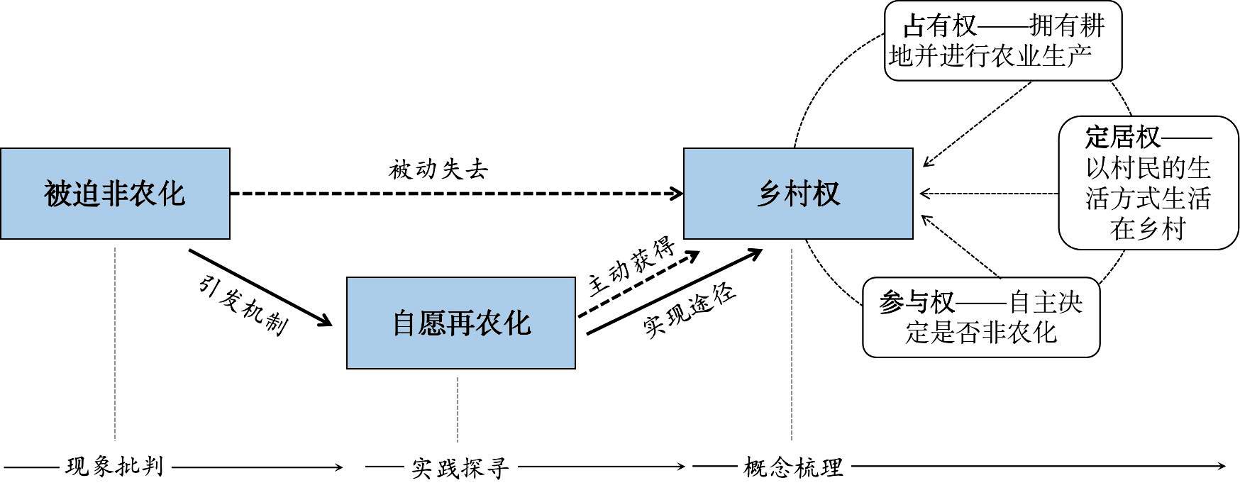
The concept of "the right to the village (RTV)" is a recent extension of the Spatial Justice theory, i.e., the right to the city in particular, into the rural context, which critically reveals and investigates the deprivation of spatial rights in the allocation of spatial resources (mainly land) and the production of rural spaces. By adopting the critical perspective of radical geographers, this study conceptualizes the RTV through focusing on power struggles in the possessing of "rural land" and in the defense and redefining of "villagers' identity". This study was based on a review of the case studies of countries in the Global South, i.e., Tunisia, India, and Lebanon, as well as those of countries in the Global North, i.e., Great Britain, France, and Italy. Firstly, the study critically examined the difficult situations of villagers in maintaining their production system, living environment, and state-of-mind in expanding urban territory and mindset, using the term "forced depeasantization". Secondly, it explored the individual or collective struggles of villagers in the search for spatial justice, which was termed "voluntary repeasantization", including actively striving for land rights and interests using formal or informal means and silently guarding their identity as farmers explicitly and implicitly. By comparing available case studies, analysis revealed that the forced depeasantization in the Global South and Global North share one common aspect, in which the essence of all is the deprivation of rural land and villagers' identity caused by capitalist exploitation. Meanwhile, their experiences are different in terms of voluntary repeasantization adopted in contexts. In the Global South, villagers choose to demonstrate their "rights" through legal channels or extreme ways, while in the Global North, villagers assert their "rights" by relying on top-down national policy and bottom-up local capacity-building. Thirdly, this study summarized the theoretical framework of the RTV, which lays out the three pillars of the RTV, which are "appropriation" (the right to own land and carry out agricultural production), "inhabitation" (the right to live in the countryside in the villagers' lifestyle), and "participation" (the right to decide whether to quit agriculture) of rural spaces. Last, but not least, this study attempted to apply the RTV to domestic rural issues. The findings suggest that, in China, the guarantee of top-down national policy is the most important way to seek spatial justice in rural areas. However, villagers' rights to appropriate, inhabit, and participate in rural development are just as important as anywhere else in the revitalization of rural China. Therefore, it is advised that knowledge sharing, community learning, and participatory decision-making should be emphasized in rural policy, as key practical methods to embody the farmers' principal position in the process.
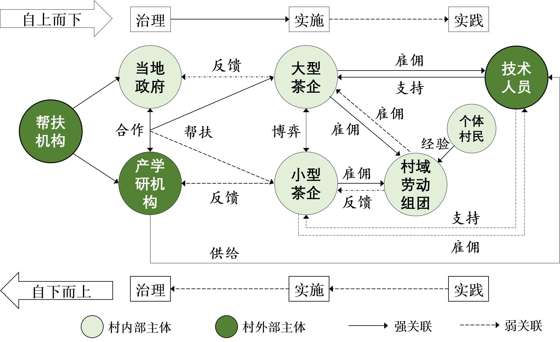
With the promotion of China's rural revitalization strategy, rural industrial formation based on digital technology is increasingly emerging. How digital technology stimulates rural industrial development as a new infrastructure force and guides the transformation and reconstruction of rural space has become a topic of concern for the Chinese government. Using field research and semi-structured interviews, this research took the tea industry in Zijin County, Guangdong Province, as an example to explore the digital construction process of rural agricultural space. Furthermore, it focused on how digital technology promoted the social and spatial organization transformation of rural areas and analyzed the operation mechanism of digital agricultural space. The main findings of this study are as follows: (1) The introduction of digital agricultural technology realizes real-time monitoring of the production space, which helps break the "black box" dilemma arising from the physical isolation of the production and sales sides, and promotes the construction of a logic for agricultural modernization operations. To support the routine operation of the technology platform, digital infrastructure and the introduction of skilled human resources stimulated the creation of new rural spatial functions. 2) Differences in the digital practices of different rural entities were observed. First, targeted digital agricultural space construction leads to differences in resource allocation among rural enterprises of different scales, which intensifies the differential development of rural space construction. Second, the top-down-led digital construction of rural areas has differences between the implementation strategies of governance subjects and the actual needs of local enterprises. This is mainly reflected in the lack of coupling between the integration of digital infrastructure resources and the granting of hierarchical technical knowledge. In addition, grassroots farmers form cognitive inertia to traditional production models and have insufficient knowledge of digital technologies, making it difficult for them to participate in the everyday construction of digital rural discourse systems. 3) Digital technology is leading the rurality turn, i.e., features digital intervention in the construction of agricultural space. Under the discourse of precise poverty alleviation and rural revitalization, the logic of digital rural operation in Zijin County centers on the three-subject framework of government, enterprise, and villagers. With the intervention of digital technology, a hybrid of multiple subjects, networks, and meanings guides the structural transformation of rurality. Overall, digital technology has triggered a reconfiguration of the spatiality of the Chinese countryside. On the one hand, it drives the spatial transformation of rural areas by guiding the transformation of rural social and spatial organization. On the other hand, the current top-down digital technology sink model of rural areas needs to be further improved due to the differences in multiple subjects in rural areas. To broaden the effectiveness of digital technology in promoting the development of rural areas, future construction of digital rural areas should deepen the bottom-up participatory transmission path and guide the participation of more diverse rural subjects.
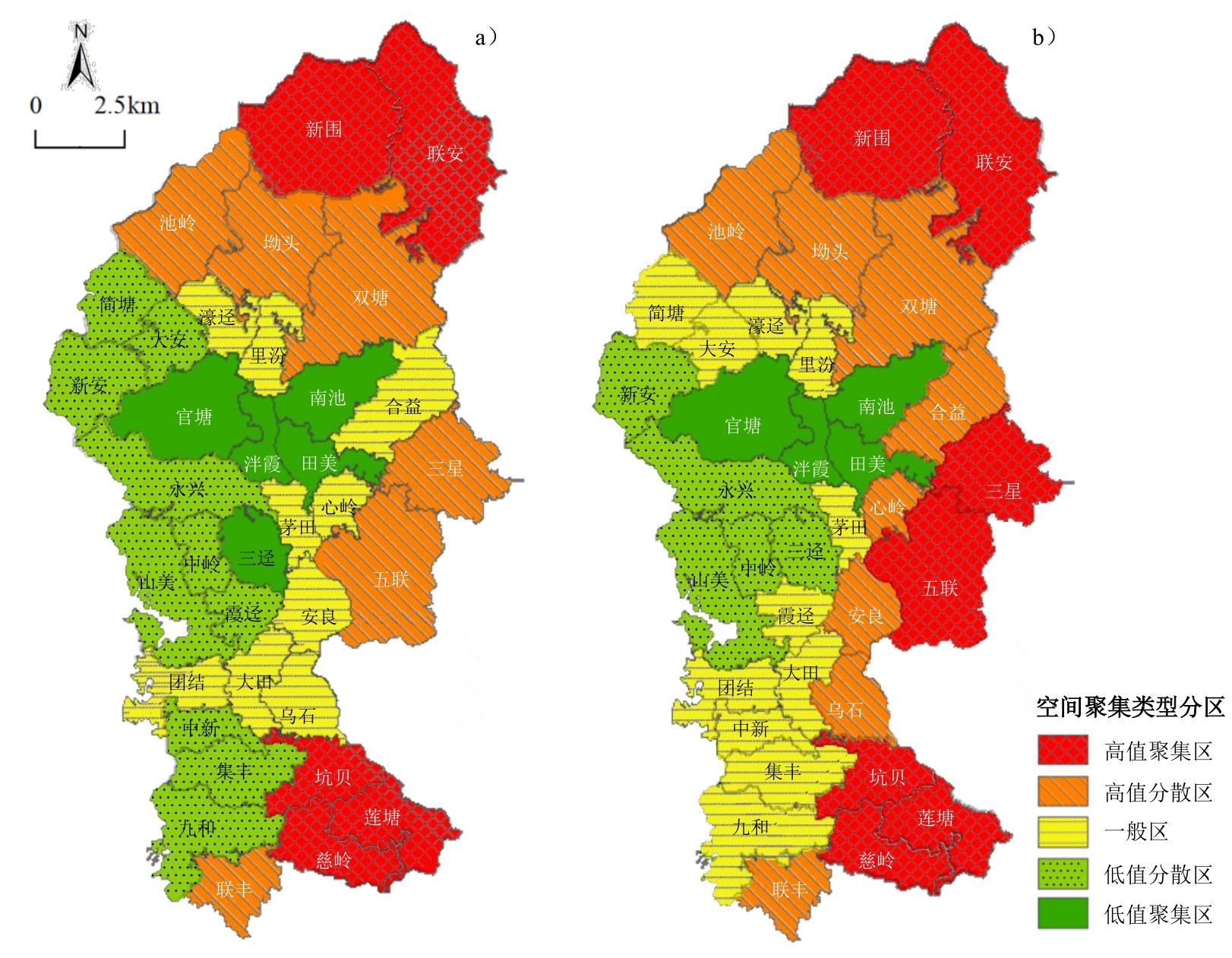
With the implementation of the rural land circulation policy, the scale and rate of land circulation in rural areas have grown rapidly. The spatial pattern of farmland circulation has also been changing, which is an important characterization of the spatial pattern of agricultural land. Most existing research focuses on large-scale farmland circulation spaces. The lack of analysis on the scale and spatial structure of such circulation has led to a lack of guidance for the optimization of farmland circulation space in rural land circulation units in towns and villages. There is also a lack of research on the measurement of farmland production efficiency at the town scale. Furthermore, a standardized and unified index system or calculation method has not been developed, making it impossible to accurately plan the rural agricultural industry and the spatial layout of farmland based on efficiency data. Taking ZX Town, Guangzhou as an example, based on land circulation data from the past ten years, this study summarizes the change characteristics of its land circulation in geographic space, combines the data of town-level farmland circulation, agricultural development, spatial characteristics, and so on, and uses the super-efficiency DEA model to analyze ten-year farmland production efficiency in the town area. On this basis, the coupling coordination degree model is used to conduct a coupled analysis of the coordination relationship between production efficiency, farmland circulation rate, and the degree of spatial agglomeration of farmland circulation. The results indicate the following: 1) From the perspective of the spatial pattern of circulation, there is a significant positive spatial correlation in the circulation of farmland in ZX Town. The overall pattern of land circulation is in a state of agglomeration and continues to strengthen, with obvious phase characteristics. There are significant regional differences in the circulation clustering space. The low-value areas of circulation space are decreasing, and the high-value areas of circulation and agglomeration are gradually forming in the southeast and northeast. 2) From the perspective of farmland production efficiency and its coordination relationship with other factors, the value of such efficiency in the town area shows an overall upward trend of fluctuation, and the coupling and coordination trend with the rate and spatial agglomeration of farmland circulation is changing from antagonism to imbalance. Owing to stability and coordination, the increase in production efficiency under a state of high turnover rate and high concentration of circulation space is prominent. This study further combines the optimization plan of the production efficiency model and the analysis of the causes of the circulation pattern and puts forward optimization suggestions on the development of the agricultural industry, the scale of farmland circulation, and the spatial pattern based on the improvement of farmland production efficiency. The results can be used as a reference for agricultural industry development planning, among others.
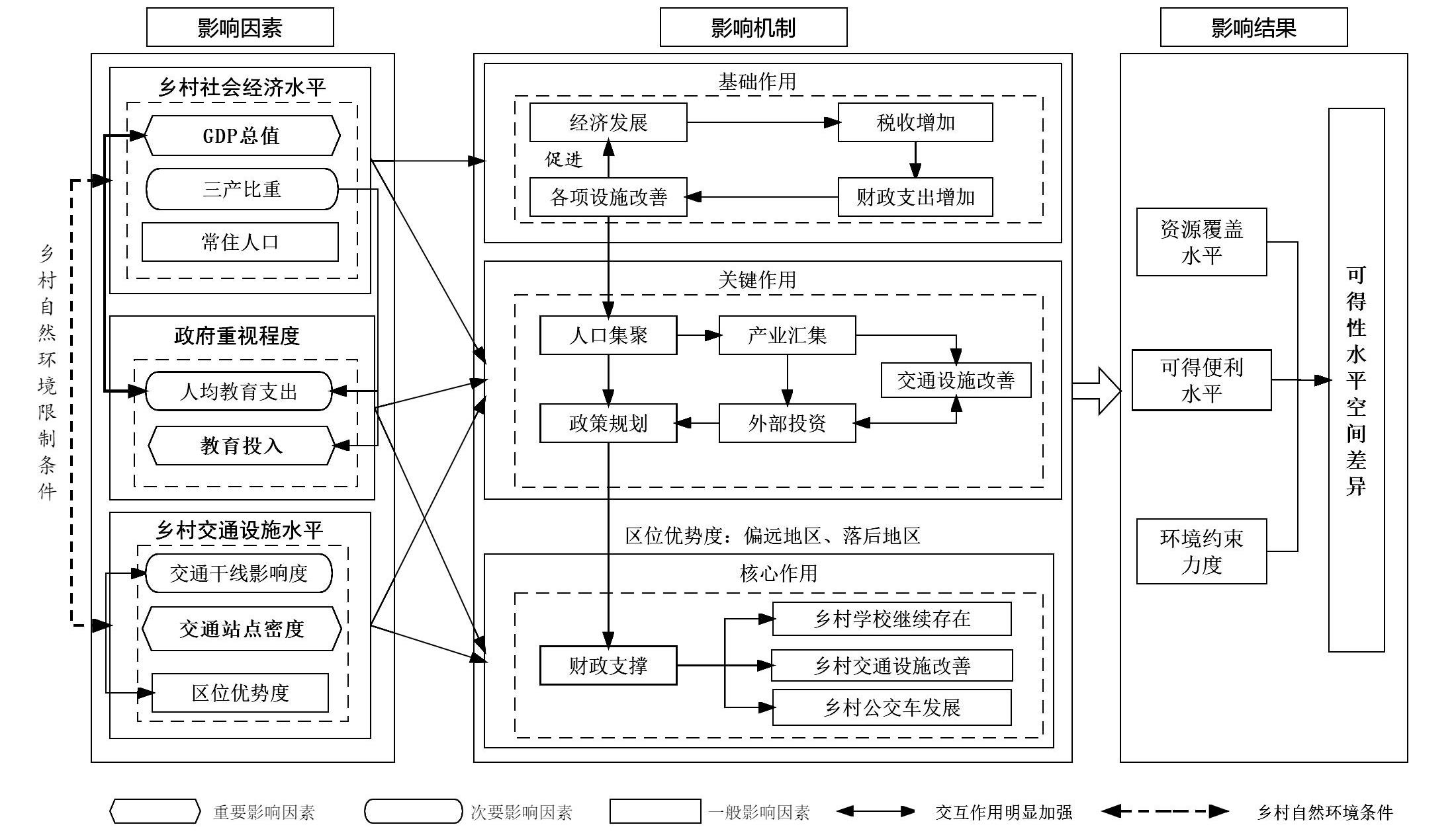
Education is the first step toward revitalizing the rural. The rational allocation of rural compulsory education resources is an important means of achieving comprehensive social development and urban-rural integration. This study used the Densi-Graph urban and rural identification method method to accurately identify urban and rural areas at the grid scale within the administrative division. Taking the rural area of Chongqing as an example, based on resource coverage, environmental constraints, and accessibility, this study explored the spatial differences in compulsory education resource availability. A spatial regression model and geographical detector were used to determine the main influencing factors. In order to provide data support and decision-making reference for the availability of rural compulsory education resources and spatial optimization of schools. The results show that the following: First, there is a significant difference between urban and rural areas based on the Densi-Graph urban-rural identification method, with the rural area of Chongqing reaching 79,752 km2, accounting for 96.82% of the total area; the urban area is 2,616 km2, accounting for only 3.18% of the total area, and is concentrated in the central city. There are significant circle layer increasing characteristics in the distribution of rural areas. From the central urban area to the periphery, the proportion of urban areas gradually decrease, and the proportion of rural areas gradually increase. The proportion of rural areas in the central urban area is 80.12%; the area of rural areas in the pioneering development areas of the same city, important strategic pivot cities, and bridgehead cities account for 95.81%, 96.32%, and 97.04%, respectively, which are higher in southeast and northeast Chongqing. Second, the availability of compulsory education resources in Chongqing has obvious spatial agglomeration and spatial correlation characteristics. High-level areas are clustered around the central urban area and scattered in the central area of the townships. Low-level areas are concentrated in backward mountainous areas, such as Chengkou, Wushan, and Pengshui. Specifically, high-level resource coverage areas are in a point-like agglomeration state in northeast and southeast Chongqing. The polarization of accessibility is significant. High-level areas only appear around the central urban area, while low-level areas are widely distributed in the west, northeast, and southeast of Chongqing. The degree of environmental constraint varies with terrain, and the spatial differences are small. A small number of low-level regions are concentrated at the junction of Chengkou, Kaixian, and Wuxi, with large terrain fluctuations. Overall, the availability level of compulsory education resources in rural areas of Chongqing shows a spatial difference pattern of decrease from the urban center to the periphery. Third, the degree of government attention, level of social and economic development, level of transportation facilities, and natural geographical environment are all related to the availability of compulsory education resources, but the degree of influence varies. Location dominance, slope, and topographic relief are negative factors, whereas the remaining factors play a positive role. Fourth, regional socioeconomic development affects the distribution of regional compulsory education resource points and investment in compulsory education, which is the basis for affecting the availability of resources. Public transport routes and traffic site density are key indicators affecting the availability of compulsory education resources, and there is significant interaction between social and economic development and education investment. Guaranteeing investment in education, optimizing the distribution of compulsory education points, and strengthening public transportation are equivalent to providing financial support and government attention. These are at the core of guaranteeing improvement in the level of availability of compulsory education resources in rural areas.
Tropical forests are considered the most abundant source of biodiversity in the terrestrial ecosystem and the key to international biodiversity conservation. Due to the rapid process of urbanization and land conflicts, regional ecological security is under tremendous pressure, resulting in biological habitat destruction, ecosystem service degradation, biodiversity reduction, etc. Consequently, the construction and optimization of ecological security patterns can improve ecological environment stability, restore ecological function, and protect biodiversity, which is an important spatial way to solve regional ecological environment problems and improve regional ecological security. In this study of Xishuangbanna, Yunnan Province of China, ecological sources were obtained through ecological system service and ecological sensitivity comprehensive superposition, followed by ecological source extraction through hot spot analysis. The resistance coefficient was modified on the basis of the land cover type through landscape fragmentation comprehensive index construction, and Linkage Mapper calculation was performed to calculate ecological corridors and nodes with the ArcGIS cost-distance analysis module to construct and optimize the ecological security pattern in the Xishuangbanna area. The main results are as follows: (1) Twenty important ecological source areas were extracted from the Xishuangbanna area, covering a total of 7,709.56 km2 and accounting for 40.33% of the study area. The coincidence rate with the existing nature reserves is 89.92%, which is mainly distributed in natural reserve areas, such as the northern part of Jinghong City, Central and southern parts of Mengla County, and the southern part of Menghai County. (2) Compared with the resistance surface corrected by night light data, the spatial differentiation of the landscape resistance surface corrected on the basis of landscape fragmentation is more significant. Among this, the identification of ecological corridors, the spatial distribution of the corridors, the reduction of conflict points of human activities, network connections, and optimal corridor verification delivered relatively better results. (3) The ecological corridor, which includes the key corridor and the potential corridor of 278.59 km and 631.73 km, respectively, shows a spatial pattern combined with the half ring and the small rings. Moreover, the ecological nodes include 20 resource strategic points, four ecological strategic points, 27 ecological temporary rest points, and 24 ecological fracture points. (4) By referring to the ecological security patterns of Xishuangbanna area, the layout of the ecological spatial structure was optimized as "one belt, one corridor, and four groups." "One belt" was the ecological river corridor belt with the Lancang River as the main axis and the tributaries on both sides. "One corridor" refers to the central corridor structure connecting the national nature reserves of Mengyang, Naban River, and the Mangao Nature Reserve. Based on the existing nature reserves, the four groups were divided into the Bulong-Mangao nature reserves, Menglun three sub-reserves, Mengla-Yiwu-Mengyang-Menglun nature reserves, and Mengla-Shangyong nature reserves. This study provides a practical case for formulating ecological and environmental protection in Xishuangbanna.
The expansion of rubber plantations is an important driving factor and main manifestation of land use/cover change in Xishuangbanna, which has extensive socio-economic and eco-environment effects locally. However, to our knowledge, the expansion trends of rubber plantations are still not clearly understood, such as the distribution characteristics and changes of rubber plantations in traffic corridors, along rivers, and along border regions. Based on the 30 m resolution rubber plantations dataset of Xishuangbanna from 1987 to 2018, we used GIS spatial analysis methods, such as overlay and buffer, to compare the spatial characteristics and regional differences of rubber plantations along roads, rivers, and boundary lines in the past 32 years. The results were as follows: Firstly, from 1987 to 2018, rubber plantations in Xishuangbanna expanded significantly in traffic corridors, along rivers, and along border regions. The planted area of rubber plantations increased by 1,874.6 km2 within 5 km along the roads, 1,484.6 km2 within 5 km along the rivers, and 1,393.1 km2 in the border regions (i.e., a buffer of 20 km). Secondly, roads have been affected by the accessibility of rubber farming and transportation. Over the past 32 years, the average proportion of rubber plantations within the 5 km buffer zone of the roads has exceeded 90%. Roads play an important guiding role in the location selection of rubber plantations. Rubber plantations are planted in areas close to roads, rather than areas far from roads with poor accessibility, because it is not convenient to pick rubber or undergo rubber plantation replacement otherwise, and this may reduce planting or result in a switch to other cash crops. Thirdly, rivers and water source irrigation are important conditions and limiting factors for rubber plantation expansion. In the past 32 years, the average proportion of rubber plantations in the 5 km buffer zone along the rivers has been 69.7%. It is worth noting that, as a result of natural rubber prices remaining low, urbanization, and ecological environmental protection, the planted area of rubber plantations along the river began to decline in the 2010s, especially within 2 km along the line. Finally, in border regions, the rubber plantations showed obvious characteristics of border-proneness in Xishuangbanna. Over the past 32 years, the average proportion has been 55.6% of rubber plantations in the border regions, and this increased from 35.4% in 1987 to 66.2% in 2018. In particular, the expansion area and rate of the Sino–Myanmar border are higher than those of the Sino-Laos border. This study is helpful for clarifying the spatial distribution and change trend of rubber plantations in Xishuangbanna. It provides support for future rubber plantation planting and cross-border cooperation.
There is a close quantitative relationship between crown traits and trunk traits and the relationship can be used to invert each other, calculate forest biomass and stock volume, and guide afforestation practice. The correlation between tree crown and trunk traits is quite different in different regions, and relevant research on the Nanling mountains is lacking. To find out the correlation between canopy and trunk traits and its relationship with altitude in the Nanling mountains, as well as to explore the feasibility of retrieving trunk traits and calculate forest biomass and stock in these mountains, forests with broad-leaf trees distributed at different altitudes (600, 800, 1000, 1400, and 1600 m) in these Mountains were selected as the research objects for this study. Unmanned aerial vehicle remote sensing was used to obtain canopy traits such as crown width, crown circumference, and crown area (CA) of canopy tree species. The correlation between basal diameter (BD) and tree trunk traits-Diameter at breast height (DBH), diameter at 2 m height (D2), and diameter at 4 m height (D4)-were investigated and regression equations were established. A high correlation was observed between crown traits and trunk traits in the Nanling mountains, and the correlation was statistically significant to invert trunk traits from crown traits. The correlation between tree crown traits and trunk traits significantly differed with elevation in these mountains, revealing an "M" shaped change with elevation. Among the crown traits selected in this study, the correlation between crown area and trunk traits was the highest, implying that it could be used solely for inversion of trunk traits. The specific equations were as follows:
Facing a great era that promises unprecedented changes, intellectuals need to understand the relationship between time and space, society, and themselves. Intellectuals are broadly restricted and influenced by time, space, and social environments; however, it is also possible for them to transcend time, space, and society. Taking the historian Cho-yun Hsu as an example, this study elaborates and extends his viewpoints regarding intellectuals, and points out that unity of knowledge and practice is the spirit of intellectuals. True humanism is embodied in unbridled enthusiasm and sensitive insight into academics and life, with both values and depth of thought, and the conversion of knowledge into action to pass on and cultivate talents. Only by discovering and building upon real human nature and life can intellectuals achieve transcendence. To recognize the limits of the world and oneself, and to do everything possible to break or surpass these limits, is to face and create the future.