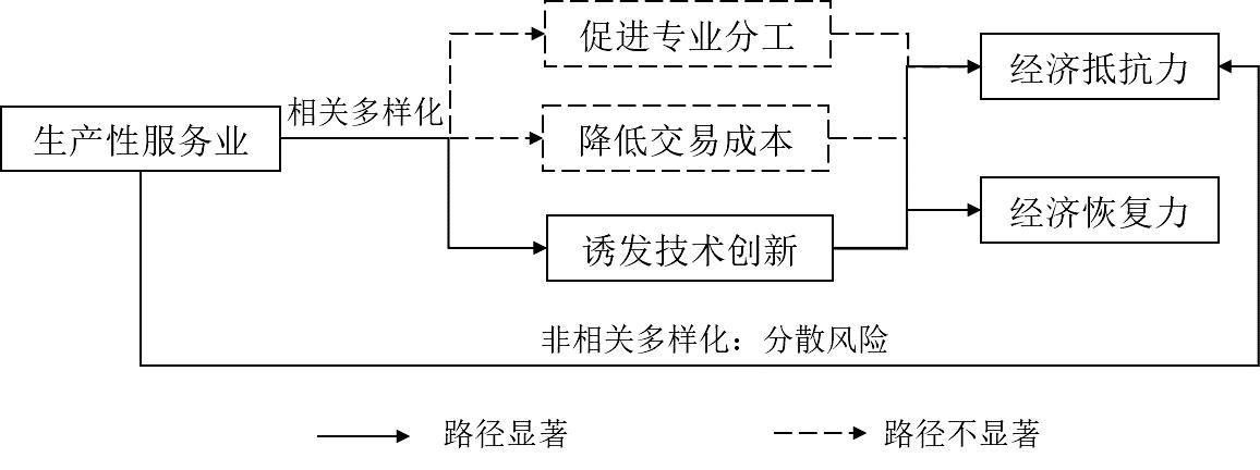
With the increasing complexity and uncertainty of regional economies, economic resilience has become a hot research topic in economic geography in recent years. Industrial structure is considered the most important factor in explaining differences in regional economic resilience. However, they tend to focus on the industrial sector without paying adequate attention to producer services, which have played an increasingly important role in the economy. Theoretically, producer services can deepen the division of labor and provide specialized services, reduce transaction costs and improve efficiency, promote knowledge and technology spillover effects to resist crises, create new paths through related diversification, and spread the risk of external shocks through unrelated diversification. This study attempted to probe into the relationship between producer services and economic resilience. According to China's GDP growth, the period from 2007 to 2012 was the resistance period and the period from 2012 to 2017 was the adjustment period. In a period of resistance, economic resilience refers to economic resistance, and in a period of adjustment, resilience refers to economic recoverability. Based on an analysis of 285 cities at and above the prefectural level in China in the "post-crisis" era using a multiple mediation effect model, three main findings can be drawn. First, producer services have not only directly enhanced the economic resilience of cities by enlarging the unrelated variety of the industrial structure but also indirectly enhanced urban economic resistance and recoverability by increasing the related variety of urban industrial structures to induce technological innovation. Second, the degree of separation between producer services and the manufacturing industry in China remains low, and the mediating effect of producer services on economic resilience through deepening specialization and reducing transaction costs is not significant at present. Third, the impact of producer services on urban economic resistance and recoverability differs among eastern, central, and western cities owing to differences in the development level of producer services and economic structure. The direct and indirect impacts of producer services in the eastern cities are more prominent. The impact in central cities is likely to be indirect, mainly through the mediation effect of scientific and technological innovation. The effect of producer services on economic resilience in western cities is not significant. Fourth, among the four subgroups of producer services, the direct and indirect impacts of information transmission, software, and information technology services are the most significant. Owing to their relatively close relationship with low-tech industries, the impact of business services on economic resilience is weaker than that of other producer service sectors. This study is a useful supplement to the existing studies on economic resilience which tends to be "industry-oriented".
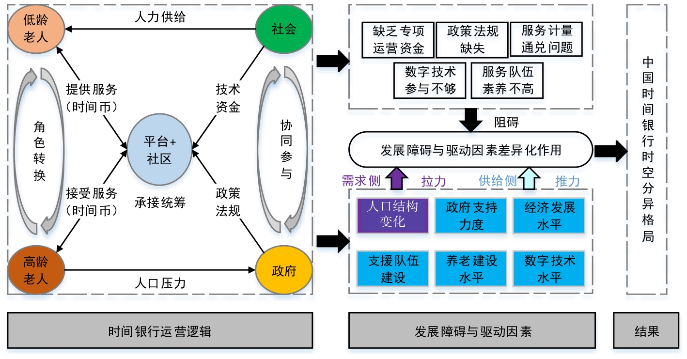
Combining the development history of mutual assistance and old-age care of Time Banking under the background of aging in China has important reference significance for addressing the Time Banking development dilemma. Using news reports on the establishment of Time Banking in Baidu from 1998 to 2020, this study extracts the time and place of its establishment through manual interpretation, and analyzes the temporal and spatial distribution characteristics of Time Banking. Additionally, it discusses the driving factors and differentiation mechanism to restore the development history of Time Banking from the perspective of social attention and provide a useful reference for its current status from the perspective of geography. It was found that: 1) Time Banking has experienced three periods of development in China, and the number of branches has shown an overall upward trend, among which the third period had the largest increase. 2) In terms of urban and rural distribution, Time Banking was mostly concentrated in urban areas and gradually spread to rural areas. In the provincial distribution, most provinces had already explored Time Banking, among which Jiangsu, Hubei, Zhejiang, Guangxi, and four other provinces (regions) had the largest number. 3) The spatial distribution of Time Banking initially showed a small sporadic distribution, which then gradually developed into a double-center distribution pattern in the Central Plains of the Yangtze River Delta. These were concentrated south of the Hu Huanyong line and was generally "dense in the southeast-sparse in the northwest". 4) In terms of the spatial relationship, Time Banking develops gradually from the initial spatial divergence to a spatial agglomeration. The degree of agglomeration is constantly strengthened, tends to be stable, the spatial homogeneity is gradually enhanced, and the heterogeneity is gradually weakened. 5) The driving factors of Time Banking development include population structure, old-age construction level, economic development level, government support, volunteer team construction, and digital technology level. Among them, the old-age construction level is more important in the first period, while the government support level and economic development level are more important in the second and third periods. Finally, it is suggested to increase the exploration of Time Banking and reduce the dependence on social and economic development indicators to provide a feasible path for their balanced development in underdeveloped areas, such as the northwest and northeast rural areas. Additionally, government support should be strengthened and multi-stakeholder participation guided to guarantee the sustainable development of Time Banking.
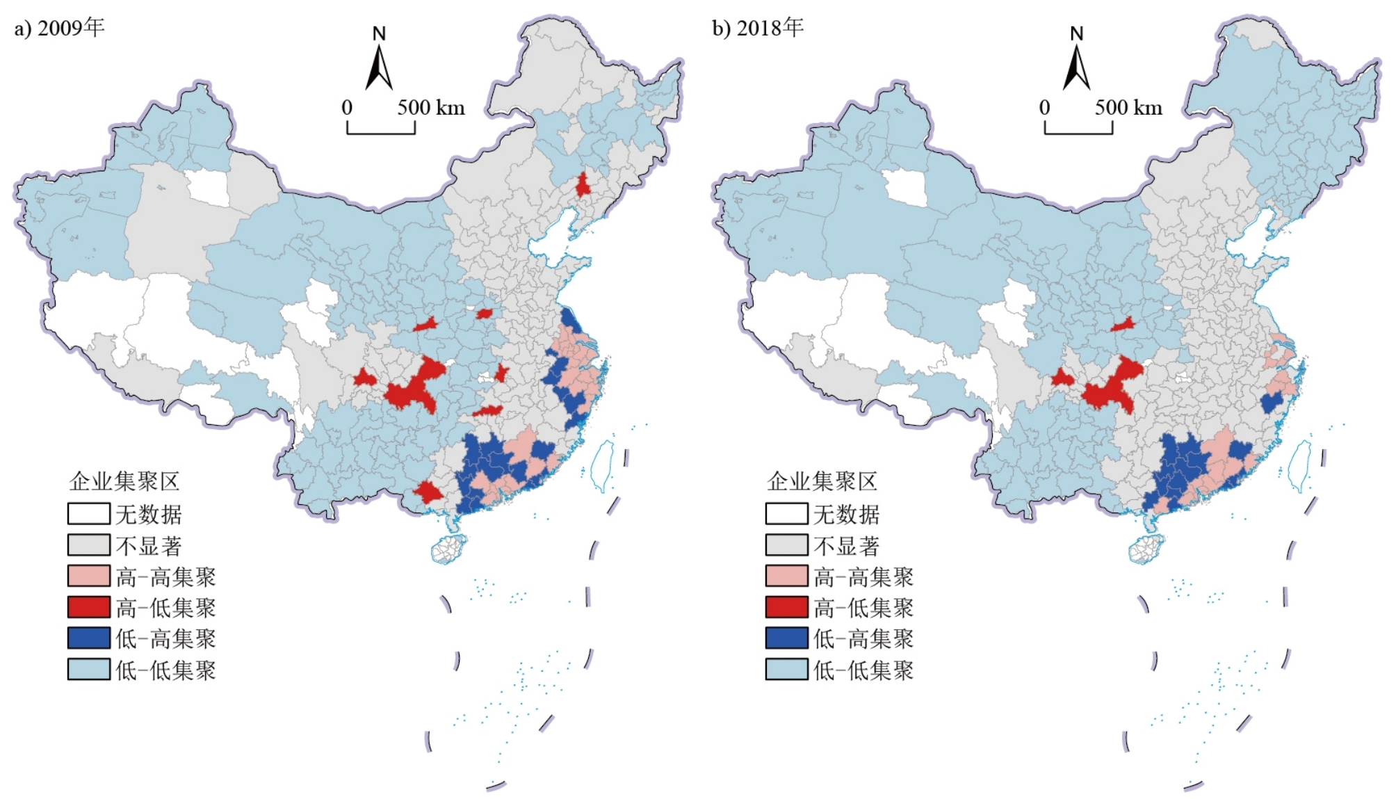
After the global economic crisis of 2008, China's electronic information manufacturing industry faced the dual challenge of expanding the scale of agglomeration and improving growth quality. The spatiotemporal pattern of the development of the electronic information industry is constantly changing because of globalization, national policies, and local production networks. To understand the spatiotemporal changes and mechanisms of the Chinese electronic information manufacturing industry in the post-economic crisis period, this study uses electronic information manufacturing enterprises (EIMEs) at the city scale from 2009 to 2018 as the research object, and uses the Gini coefficient, spatial correlation analysis, and negative binomial regression model to analyze the evolution of the spatiotemporal pattern of the Chinese electronic information manufacturing industry and its influencing factors from 2009 to 2018. The main conclusions are: (1) The characteristics of the spatiotemporal evolution of the electronic information manufacturing industry are as follows. On a national scale, the Chinese electronic information manufacturing industry is developing rapidly, but its development is unstable due to the influence of the international situation. At the scale of the city cluster, the electronic information manufacturing industry mainly concentrates on the Pearl River Delta and Yangtze River Delta, and the middle reaches of the Yangtze River are ready for development. At the city level, the ranking of the top ten cities in China is stable. The cities in the central region and Sichuan-Chongqing regions are developing rapidly, while cities in northeast China are in a developmental dilemma. Spatial correlation analysis revealed a significant positive spatial correlation between the distribution of EIMEs in China. (2) The empirical analysis of location choice shows that there is heterogeneity among different city clusters owing to different factors. At the national level, EIMEs are more likely to be located in cities with high labor costs, a high degree of industrial collaborative agglomeration, strong local innovation ability, and low economic development. Enterprises in the Yangtze River Delta region prefer cities with high innovation abilities. In contrast, those in the Chengdu-Chongqing city cluster prefer cities with low innovation abilities. Labor costs have a positive effect in the Beijing-Tianjin-Hebei city cluster and the middle reaches of the Yangtze River. Industrial collaborative agglomeration has a positive impact on the Chengdu-Chongqing region. The level of industrial marketization has a positive effect on the Yangtze River Delta and the Chengdu-Chongqing city clusters. The economic development level negatively affects the middle reaches of the Yangtze River and the Chengdu-Chongqing city cluster. The level of transportation infrastructure has a positive effect on the Yangtze River Delta and Beijing-Tianjin-Hebei. The minor contributions of this study include two aspects: In terms of theoretical contribution, this study enriches the theoretical results of research on the electronic information industry in economic geography and provides a specific reference for research on other sectors. In a practical sense, this study is conducive to an in-depth understanding of the changes and development trends of China's electronic information manufacturing industry in the post-economic crisis period and provides a reference for local governments to formulate corresponding industrial development strategies and policies and promote the upgrading of China's industrial structure and the coordinated development of the regional economy.
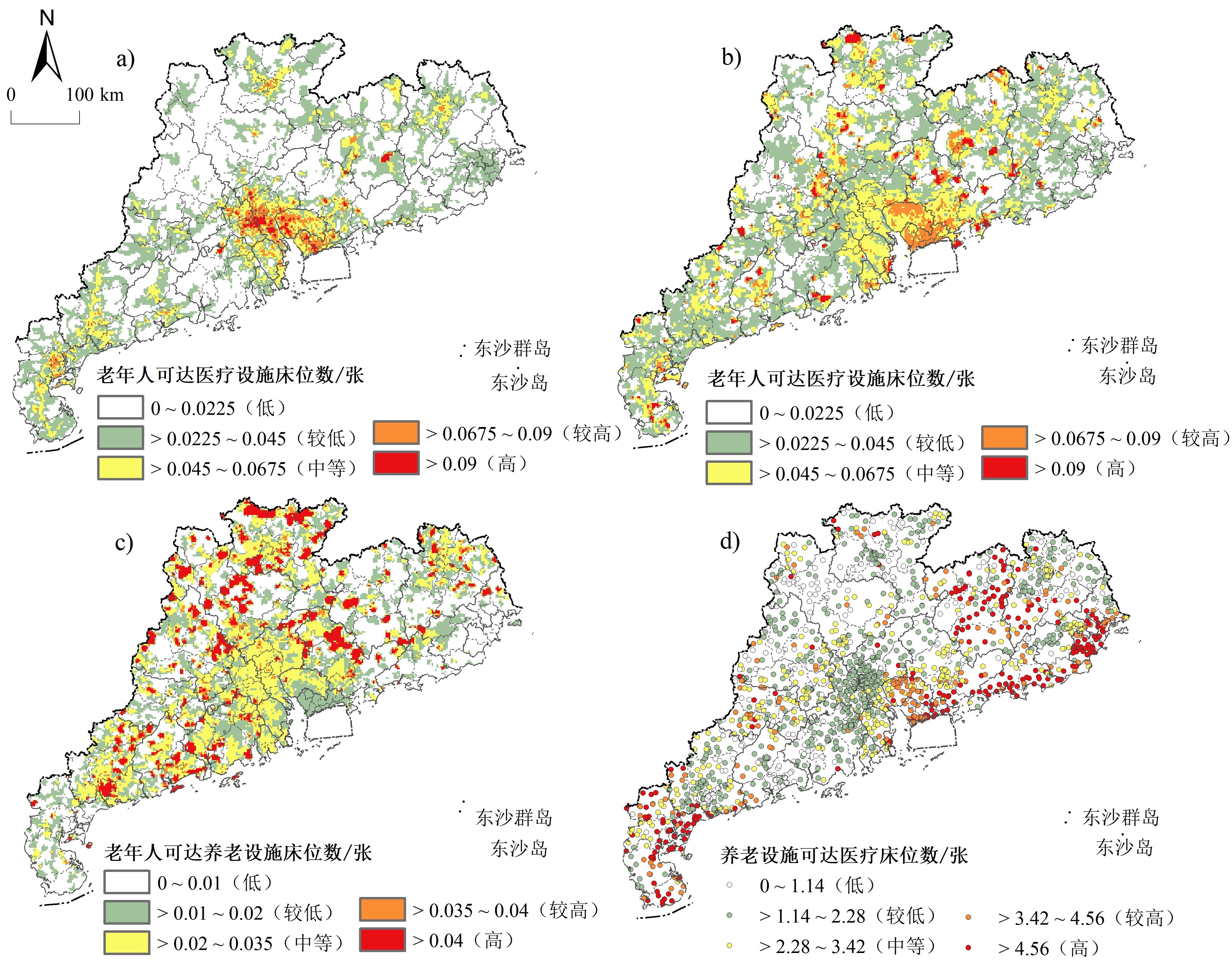
With the rising aging population in China, increasing attention has been paid to the spatial layouts of medical and residential care facilities; however, the accessibility and aging suitability of these facilities have received less attention. Taking Guangdong province as an example, this study used the improved two-step floating catchment area method to measure the accessibility of medical and residential care facilities and summarized their spatial pattern characteristics from four dimensions (1 km, four regions, cities, and counties). A correlation was established between the elderly population density data and their degrees using the autocorrelation analysis method and the Gini coefficient to analyze the aging suitability and equality of medical and residential care facilities. Finally, the Spearman correlation coefficient was used to analyze the factors influencing the accessibility and equality from three aspects, namely: the natural environment, society, and economy. The following results were obtained: 1) Compared with the Gaussian two-step floating catchment area method, the improved two-step floating catchment area method was more accurate in reflecting the accessibility of medical and residential care facilities; this showed that the accessibility of downtown areas was relatively lower and that of the suburbs was relatively higher, and the distribution of accessibility values was more reasonable. The results of the improved two-step floating catchment area method revealed an obvious spatial imbalance in the accessibility of medical and residential care facilities for the elderly and the accessibility of medical facilities for the residential care facilities in Guangdong Province. The accessibility of medical and residential care facilities for the elderly in the Pearl River Delta region is relatively good, whereas that in the eastern and western coastal economic zones is relatively poor. However, the Pearl River Delta region has the worst accessibility to medical care facilities for residential care facilities among the four regions and efforts are still needed to realize a combination of medical and residential care. 2) The medical and residential care facilities in the Guangzhou-Foshan metropolitan area and the northern part of Meizhou city were not suitable for the elderly. There was a substantial inequality in the accessibility of medical and residential care facilities for the elderly in Guangdong Province. The accessibility of medical facilities for the residential care facilities in Guangdong province is more equal, but there is still a large inequality; 15 cities in Guangdong province have Gini coefficients greater than 0.5. 3) Road network density, population density, per capita GDP, and local financial expenditure were significantly correlated with the accessibility of medical and residential care facilities. The average altitude, eco-environmental status index, area, road network density, population density, per capita GDP and public financial expenditure were significantly correlated with the equality of medical and residential care facilities for the elderly in Guangdong Province. The results of this study can provide a reference for optimizing the allocation and layout of medical and residential care facilities in Guangdong Province.
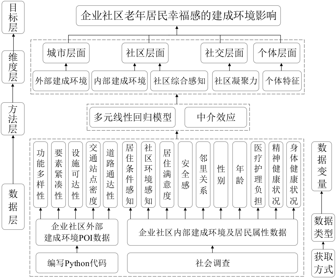
In the context of social aging and urban renewal, deepening the transformation logic and humanistic care of residential spaces in the inner city is of great practical significance. Existing studies on the built environment of cities and residents' well-being are mostly empirical studies conducted in different geographical backgrounds. Relevant studies have paid more attention to the well-being of residents in this region. However, only a few studies have been conducted in specific regions or populations. In particular, research on the impact of well-being among older groups in relatively poor neighborhoods is lacking. Enterprise communities (ECs) are walled-off residential spaces that were built and managed mostly by the state or collectively owned enterprises to house workers during the planned economic period. Many ECs are still used in urban China; however, they have a large proportion of older adults, outdated buildings, and facilities. EC is an important place for urban renewal and inner-city space reuse, and it is typical and representative to explore the impact of the built environment on the well-being of older residents. The quality of the internal and external environments has a profound impact on the well-being of residents. This study constructs an analytical framework of 15 concept variables in five dimensions: external built environment, internal built environment, comprehensive community perception, community cohesion, and individual characteristics. Based on the Point of Interest (POI) data and social survey data in the built environment of Xi'an enterprise communities, this study establishes a hierarchical linear model and conducts a mediating effect test. Thus, we can quantitatively explore the impact of the built environment on the well-being of older residents in enterprise communities. The study found that the overall level of happiness of older residents in the EC was average, with an average score of 3.54 points. The accessibility of external environmental places, such as scenery, medical care, and public facilities, which are closely related to daily life, promotes the well-being of older residents. Older residents' subjective perception of living conditions, community greening configuration, internal roads and landscapes, and comprehensive perception of the community can positively affect their well-being. Compared to the external built environment, the internal environment of the community is more closely related to the life and travel of older residents and has a stronger impact on happiness. Therefore, the internal environment of a community is the focus of construction to improve residents' happiness and quality of life. In addition, regarding the impact of the POI entropy index and accessibility of public facilities on the well-being of older residents, residents' comprehensive perception of the community plays an intermediary role. This study proposes some built environment improvement suggestions on the construction of landscape green space and improvement in medical service stations and the service quality of public facilities, as well as optimization of the living environment, improvement of housing conditions, and construction of community older care institutions. Overall, insight into the impact of the built environment on the well-being of older residents in enterprise communities will not only help strengthen the awareness of residents' well-being but also enrich the theory of unit communities and succession of urban residential spaces. To enhance residents' well-being, this study provides corresponding planning strategies in terms of effectively supplying daily life circle spaces and optimizing the public service system to increase the scientific connotation of urban renewal.
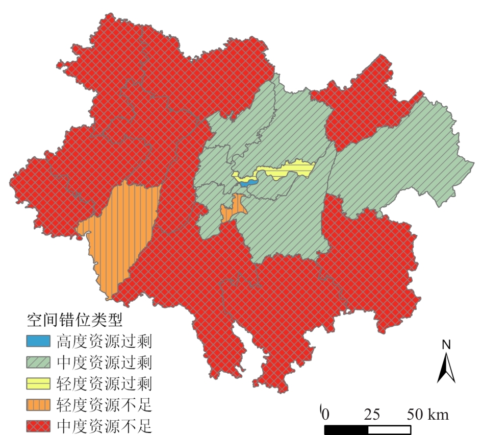
As population aging continues to diverge with spatial and temporal evolution, problems such as mismatches between the elderly population and elderly service resources, inadequate utilization, and unreasonable planning layout are increasingly highlighted, and scientific planning for the allocation of elderly service resources is pertinent. Revealing the coordinated relationship and driving mechanism between population aging and elderly service resource allocation at the current stage is the first step in formulating and implementing the plan. Therefore, this study considers Chongqing's main city metropolitan area, where the demand for elderly services is relatively strong, as its research object. Based on the data from the seventh population census and the current regional planning of Chongqing, the study area was divided into the central city and the main city new area, based on which the population aging coefficient and the number of the elderly population were used to analyze the spatial distribution characteristics of population aging in the Chongqing's main city metropolitan area and construct a comprehensive index of elderly service resource allocation. Combined with the Thiel index to explore the balanced characteristics of elderly service resource allocation, the spatial mismatch index and Geodetector were used to explore and analyze the spatial mismatch phenomenon and driving mechanism of population aging and elderly service resource allocation in the study area. The results show that, first, the spatial distribution characteristics of the population aging coefficient and the size of the elderly population in the main city metropolitan area of Chongqing in 2020 are consistent, showing the characteristics of a circular structure decreasing from the inner central city to the outer main city new area. Second, the spatial distribution of the elderly service resource allocation in the main city metropolitan area of Chongqing in 2020 is uneven, with the central urban area forming a hotspot for elderly service resource allocation evaluation, while the main city new area forms a low-value ring for elderly service resource allocation evaluation. Third, there is a spatial mismatch between population aging and elderly service resource allocation in the Chongqing's main urban metropolitan area in 2020, and the contradiction between excess resources in the central urban area and insufficient resources in the new urban area is prominent. Fourth, regional differences in government policies, residents' income levels, population structure, and industrial structure significantly affect the coordinated development of senior care service resources, while the expansion of the market economy, the shrinking of household size, and the intensification of population aging fail to effectively promote the coordinated development of senior care service resources. This study explores the intrinsic connection between population aging and elderly service resource allocation and its driving mechanism from a matching perspective. It provides a scientific basis for promoting the coordinated development of population aging and elderly service resource allocation.
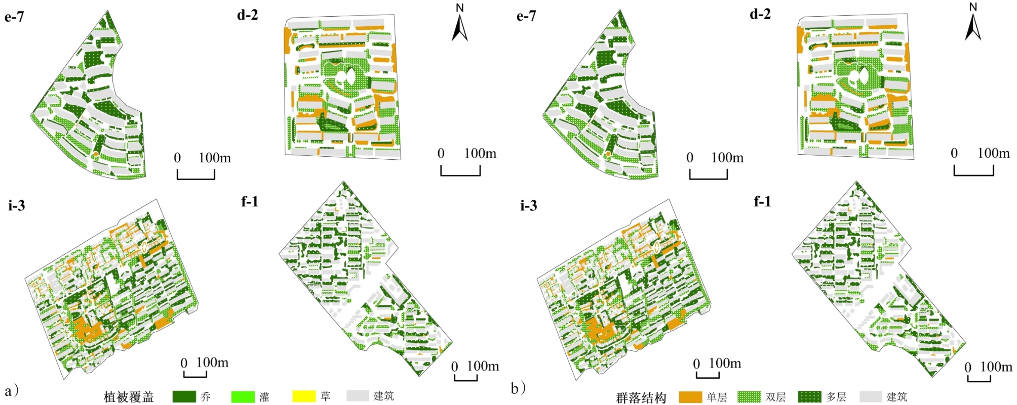
Urban green spaces can purify the environment, beautify the landscape, enhance the diversity of the ecosystem, improve the quality of space, and effectively promote public health. Green spaces can also improve residents' mental health by reducing pressure, promoting outdoor exercise, and increasing social capital. The spatial difference in green space distribution aggravates the differences between different social and economic groups and has different effects on their mental health. Many studies have focused on the relationship between the green space scale and mental health; however, only a few have explored the impact of green space structure. It is necessary to study the impact of the quantity and structure of green spaces in different neighborhoods on mental health from the perspective of green space equality. Taking the suburbs of Shanghai as a case area, this study focuses on the impact of neighborhood green space on mental health by integrating a questionnaire survey and multi-source green space data. It measures the quantity and quality of neighborhood green spaces and compares them among different neighborhoods. The quantity of green space is measured by the green space rate in neighborhoods and the NDVI around 1 km distance from neighborhoods. The structure of green space consists of the vegetation community structure, foliar habits, vegetation coverage, and accessibility of parks. Then, we constructed five ordered logit models to analyze the impact of green space scale and structure in high-end, low-end, inner suburban, and outer suburban neighborhoods on the mental health of residents. As this study mainly focuses on residents' green space and mental health, the research also controls for individual socio-economic attributes, activity variables, and neighborhood-built environment variables. The results show that: 1) The scale and structure of green spaces in different neighborhoods were significantly different. The difference in green space in high- and low-end neighborhoods was more significant than that in the inner and outer suburban neighborhoods. For inner suburban neighborhoods, the quantity of green space was better, but the accessibility of parks was lower than that in outer suburban neighborhoods. 2) Increasing the proportion of trees and shrubs in the neighborhood and increasing the accessibility of parks around the neighborhood was beneficial for the residents' mental health. 3) The mental health of residents in low-end neighborhoods was significantly affected by the vegetation coverage in the neighborhood and accessibility of parks. In contrast, residents in high-end neighborhoods were not sensitive to green spaces. 4) Residents in the inner suburban neighborhood were affected by the scale of surrounding green space and vegetation coverage in the neighborhood. In contrast, the green space rate and park accessibility in outer suburban neighborhoods had significant effects on the mental health of residents. Through research on low-end and inner suburban neighborhoods, attention should be paid to greenspace planning in the neighborhood. In contrast, for high-end and outer suburban neighborhoods, attention should be paid to the balance of green space inside and outside the neighborhood. This study considers both quantity and structural indicators of neighborhood green spaces, analyzes the impact of green space on mental health from the perspective of neighborhood differentiation, and enriches previous green space and mental health research that only focused on the measurement indicators of the quantity of green space.
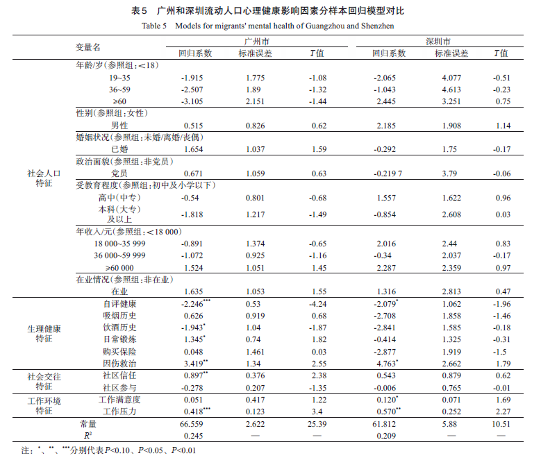
With the acceleration of urbanization and promotion of the integrated strategy of the Greater Bay Area (GBA), the number of migrants in the Pearl River Delta (PRD) has increased dramatically. With "Healthy China 2030" presented, mental health of migrants is of great significant to China's New-type Urbanization. Additionally, with the profound reforms in society and economy, the measurement and action mechanism of migrants' mental health deserve in-depth exploration. Using the data collected from the China Labor-force Dynamics Survey (CLDS) in 2016 for Guangzhou and Shenzhen and using the linear regression model, the study explored the effects of working environment, social interaction, and physical health on migrants' mental health. The second focus of this study was on the difference between migrants' mental health in Guangzhou and Shenzhen City through the empirical statistical results. Our empirical findings suggest that: 1) Migrants' mental health is significantly affected by working environment, social interaction, and physical health; among them, work satisfaction, lower work stress, community confidence, and self-rated health all have a positive impact on the mental health of migrants. Additionally, higher income is commonly associated with mental health. 2) For Guangzhou City, work stress, community confidence, self-rated health, drinking, exercise, and treatment have distinct impacts on the mental health of migrants. 3) For Shenzhen City, only work satisfaction, work stress, self-rated health, and treatment have distinct impacts on the mental health of migrants. In summary, this study used CLDS data from 609 migrants in 2016 to provide a more comprehensive picture of their working environment, social interaction, physical health, and mental health. Moreover, this study is a comparative analysis of migrants' mental health between Guangzhou and Shenzhen, which indicates that migrants' mental health in Guangzhou is mainly affected by work environment, social interaction, and physiological health; however, the work environment and physiological health play a significant role in migrants' mental health in Shenzhen. Based on the empirical findings, we call for further policymakers and practitioners to focus on both spatiality and heterogeneity in planning and governance. Municipal governments should consider the rationalization of land use and functional transformation to create harmonious social networks and promote migrants to better integrate into urban society. In addition, Guangzhou should increase and optimize leisure facilities and green space to strengthen the social interaction between migrants and locals, while it is of great importance to improve the working environment in Shenzhen and take measures to reduce migrants' working pressure by enhancing the safety and comfort of the working environment.
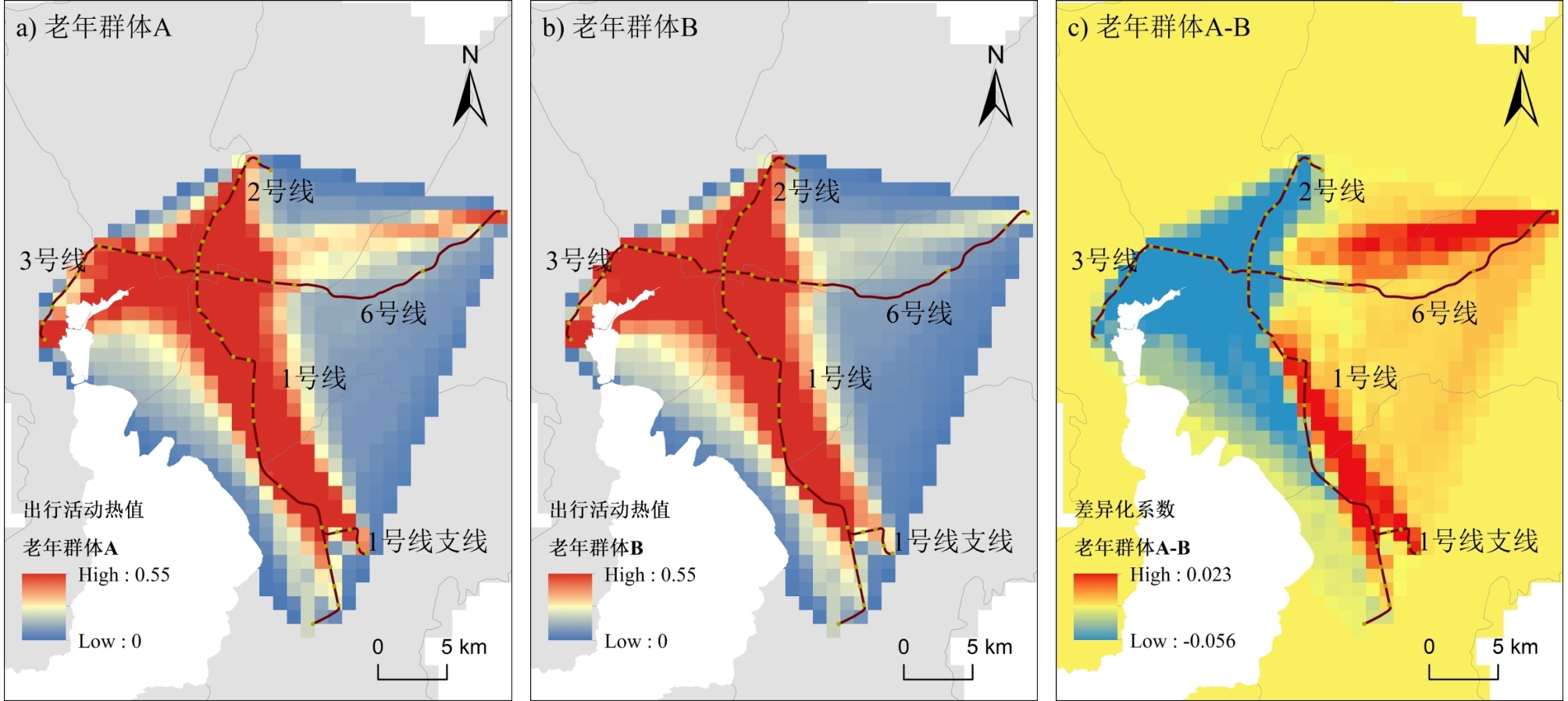
With the aging of society, the travel activities of the elderly, as a vital part of resident travel, have become the focus of transportation management in most cities. The widespread application of big data has enabled travel behavior to be analyzed in more detail, with the results revealing actual travel patterns and helping to gain an in-depth understanding of the daily travel of residents. In studies on travel patterns, several methods can be used to analyze the daily activity patterns of the elderly by combining big data with the theory of activity space. However, studies on the internal disparity in the travel behavior of the elderly remain limited. Hence, we conducted a comparative analysis of the travel behavior of age groups within the elderly from the perspective of activity space based on the smart card data of the Kunming subway system. In the analysis, we first compared the basic travel behavior of the elderly and nonelderly. Based on the findings, we divided the elderly who took the subway into 60-69- and over-70-year-old groups. Second, we compared the travel behavior and activity spaces of these two groups using a statistical and spatial analysis approach. The results showed significant differences between the elderly and nonelderly groups, the 60-69-year-old group, and the over-70-year-old group. (1) We found spatiotemporal differences in travel behavior between the elderly and nonelderly. Compared to the nonelderly group, the elderly group was less mobile. Their single-subway travel duration and frequency were lower, and they traveled more during the early peak hours. Their activity range was relatively concentrated in the city center, and their travel purposes showed a stronger orientation toward leisure and medical needs. (2) With increasing age, the elderly were less mobile, and their dependence on public transport increased. In detail, the over-70-year-old group had a shorter travel duration as well as a smaller activity space, whereas their travel frequency and number of visited stations were higher than those of the primary age group. Compared with the 60-69-year-old group, the daily activity pattern of the elderly over 70 years old could be summarized as being within a smaller activity space and higher in frequency. (3) The distribution of activity spaces of the two elderly groups was similar to each other, both in areas along metro lines 1, 2, and 3, without line 6. It indicated that the daily activities of the elderly mainly occur in central urban areas with high population densities. Regarding differences, the activity spaces of those over 70 years old were more concentrated in the densely inhabited districts along metro line 3, whereas the activity spaces of the 60-69-year-old group spread to low-density areas in the south and east. These findings may imply that factors, such as the built environment, largely restrict the subway travel of older people. In other words, their daily activities rely on facilities and transit more heavily. In conclusion, our results reveal the subway travel behavior and daily activity patterns of different-aged elderly groups, which verify the feasibility of smart card data in activity space analysis. Additionally, our study provides ideas for urban planning and transportation management in the aging era to promote social space equity.
The rapid industrialization and urbanization has reshaped the urban built environment. Meanwhile, the declining physical functioning of elderly people makes their daily activities more vulnerable to the built environment. Prior studies have examined the relationship between the built environment and older adults' leisure behavior, setting aside community differences. This paper selects three typical types of communities in Hefei, based on questionnaire-survey data. It uses the ordered logistic-regression model to identify which built-environment elements impact the leisure behavior of elderly people in different types of communities. The study finds that: 1) There are significant differences in the daily leisure-activity levels of elderly people in different types of communities. Under the influence of individual socioeconomic attributes and the built environment, elderly people living in the Danwei community have the highest levels of leisure frequency, while those living in the public rental community have the lowest. 2) Among various perceived built-environment variables, two have a positive impact on the leisure behavior of elderly people in the Danwei community: perceptions of the overall walking environment in the community and community security. In the commercial housing community, the leisure frequency of elderly people relates only to perceptions of the overall walking environment of the community. There is a positive correlation between perceptions of transportation convenience and the daily leisure behavior of elderly people living in the public rental community. 3) Among various objective built-environment variables, the relationship between the degree of mixed land use and daily leisure behavior of elderly people is positive in the Danwei community, but negative in public rental communities. In commercial housing and public rental communities, the longer the distance from the nearest bus station, the lower the frequency of daily leisure behaviors among elderly people; only in unit housing communities does intersection density have a negative impact. Considering these differences, targeted measures should be taken to improve community environments and increase leisure activity levels among elderly people: 1) In the Danwei community, we should focus on security and traffic conditions inside the community, adding safety facilities and street and area lights. 2) In the public rental communities, we should increase the density of recreational and sports facilities and the number of leisure venues, while improving accessibility. 3) Although the facilities and equipment in the commercial housing community are relatively complete, there is scope to increase green space and optimize the pedestrian environment in the community.
With the rapid progression of urbanization worldwide, the demand for sand and gravel is growing exponentially, resulting in a natural growth rate of sand and gravel far behind consumption. Unsustainable sand mining activities produce a series of environmental hazards, such as the formation of scattered sand pits in riverbeds, changes in channel shape, and altered physical and chemical properties of river water, leading to water quality degradation. Nanliu River is the largest river flowing into the sea in southwest China. The intense exploitation of river sand has had a considerable impact on the stability of the basin's ecological environment. To understand the historical change process of sand mining activities in Nanliu River and the dynamic factors influencing these activities, we analyzed their environmental impacts and provided a basis for the comprehensive management of the basin. Landsat images were used to extract the sand extraction points of Nanliu River through visual interpretation and field verification according to the image characteristics of the sand extraction points. The temporal and spatial variation characteristics of the sand extraction points of Nanliu River over the past 30 years were analyzed. The factors driving changes in the sand mining sites were explored by extracting the area of construction land in the basin, combined with economic index data and regulatory information from three aspects: economic development, changes in the area of construction land, and regulatory measures. Vectorization of sand mining areas and estuarine delta shorelines combined with water and sediment content and river water quality data were used to analyze the environmental effects caused by long-term sand mining activities from four aspects: area change of sand mining area, delta shoreline change, characteristics of water and sediment changes, and water quality change. The results show that the temporal and spatial changes of sand mining sites in Nanliu River have been remarkable in the past 30 years. The number of sand mining points increased continuously from 1988 to 2008. After reaching a peak in 2008, the number of sand mining points decreased rapidly in 2018. The changes in sand mining points were similar in different river basins and counties, with the largest number of sand mining points being in the lower reaches, followed by the middle reaches, and the smallest number being in the upper reaches. The factors driving temporal and spatial changes in sand mining sites are diverse. Rapid urbanization caused by economic development is the main reason for the increase in the number of sand mining sites. The number of sand mining sites decreased in 2018, mainly due to the continuous strengthening of sand mining supervision in Nanliu River since 2015. Sand mining activities in Nanliu River have had a great impact on the river environment. First, sand mining activities continuously decrease both the area of sand mining and the sediment load on the bed, thereby leading to a continuous decrease in the sediment load of the river. Second, sand mining is an important reason for the decline of water quality in Nanliu River. In addition, although sediment transport has decreased due to human-related factors such as sand mining activities, no remarkable erosion of the coastline in the delta area has been found to date. To contribute to this research, we first obtained research results on the temporal and spatial variation characteristics of sand mining sites in Nanliu River, and then revealed their driving factors and environmental effects, which can provide a reference for the planning of sand mining activities in Nanliu River and the comprehensive management of environmental protection. Secondly, with Landsat image as the data source, the method of extracting river sand extraction points in combination with river bed morphology and other characteristics provides a long-awaited new method and approach for studying the temporal and spatial changes of river sand extraction activities.
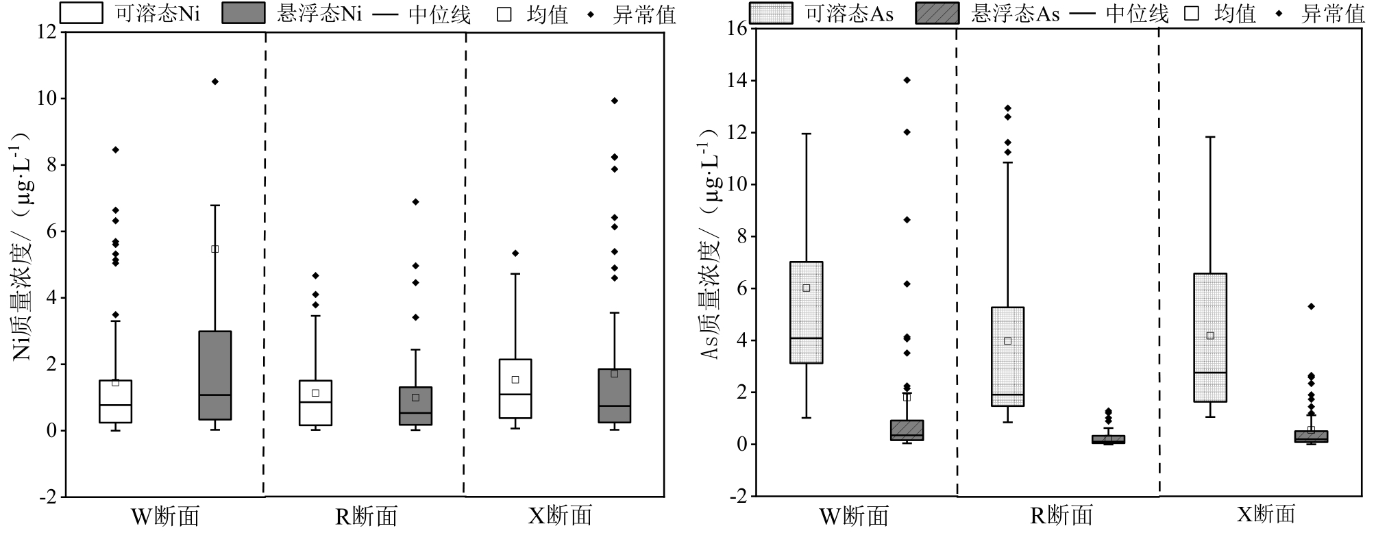
Rainfall-runoff is the main source of pollution in the urban water environment. This study investigated the dynamic changes of soluble Nickel (Ni) and Arsenic (As) in the receiving water body after the rainfall and runoff of the Meishe River in Haikou. Field sampling and indoor analysis were used. Results revealed that the solid-liquid partitioning of Ni and As in the receiving water body is directly disturbed by the inflow of rainfall-runoff. The main source of the input is the suspended state, and the input of the dissolved state is smaller. The specific performance is as follows. Before the rainfall-runoff flows into the receiving water body, the ratio of soluble Ni and As to the total content reaches 55.67% and 94.77%, respectively. After the rainfall-runoff flows in, a series of dynamic changes of Ni and As occur in the receiving water body. The proportion of soluble Ni and As at the outlet decreases significantly and changes dramatically, reaching 20.97% and 76.92% of the total content, respectively. The proportion of soluble Ni and As in the downstream of the drainage outlet also decreases to a certain extent, reaching 47.23% and 88.38%, respectively. The data under different rainfall scenarios indicate that the long dry period, when the rainfall is less than 10 mm, is the main factor affecting the dynamic changes of soluble Ni and As. Furthermore, the long dry period, along with the peak time, and magnitude of the rain intensity are the major influencing factors of the response time and degree of soluble Ni and As to rainfall-runoff, when the rainfall amount ranges from 10-30 mm. The peak time of rainfall intensity is the main factor affecting the dynamic change of soluble Ni and As in the receiving waters when the rainfall amount is above 30 mm. The effects of rainfall-runoff on the soluble Ni and As in the receiving water are different. When the dry period is short and the maximum rainfall intensity is high, in receiving water, soluble As is less affected by rainfall-runoff, while soluble Ni is significantly affected.
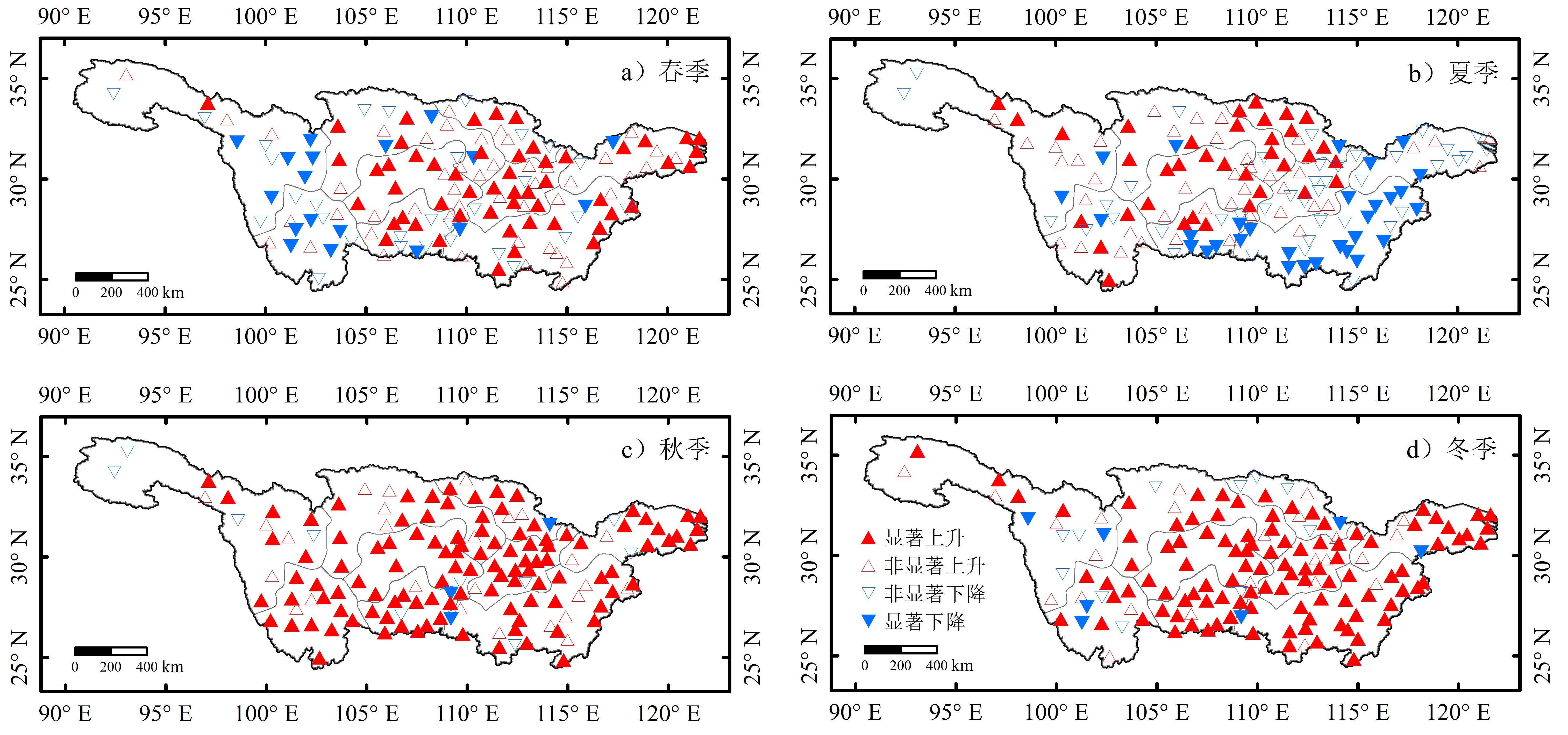
Evaporation is an important component of both hydrological and energy cycles and is very sensitive to climate change. In the context of global warming, rising temperature leads to a series of changes in hydrological factors, such as precipitation, evaporation, soil moisture, and groundwater flow, which have significant impacts on the natural environment, ecosystems, and social economy. Pan Evaporation (PE) is a vital climatic factor for estimating the atmospheric evaporation demand, and its change has been recognized as an integrative indicator of the hydrological response to climate change. Therefore, it is of great theoretical and practical significance to analyze the variation characteristics of PE and its influencing factors for water resource evaluation, hydrological process research, agricultural irrigation, and evaporation monitoring under climate change. The Yangtze River Basin (YRB) is a densely populated and highly developed area that plays an important role in the development of China's national economy. To discuss the variations in PE in the YRB and its main influencing factors, previous studies only divided the basin into upper, middle, and lower reaches based on natural and social factors. However, the area of the YRB is vast, and the PE varies greatly among the different regions of the basin under the influence of terrain and climate conditions. It is not sufficient to discuss the variation characteristics of regional PE from upstream, middle, and downstream. Additionally, most time series remained around 2000 in the existing studies, and the analysis of change characteristics of recent PE time series and its influencing factors have not been reported. Therefore, it is essential to conduct consistent regionalization for PE in the YRB and to identify the factors influencing PE variations in the subregions in recent decades. In this study, the Rotating Empirical Orthogonal Function (REOF) and Fuzzy C-Means clustering algorithm (FCM) were applied to form subregions based on pan observation data from 148 meteorological stations in the Yangtze River Basin during 1980-2017. Then, the variation characteristics and main influencing factors of PE in each sub-region were analyzed using the modified Mann-Kendall test and multivariate stepwise regression analysis. The results are as follows: (1) The first four REOF modes revealed five principal PE anomaly sensitive areas in the basin: southeast Poyang Lake plain, southwest Hengduan Mountain, northern Nanyang Basin, western Sichuan Plateau, and Central Sichuan Basin. Based on these spatial modes, the PE in the basin can be divided into nine subregions. (2) At the annual scale, PE in respective regions shows an increasing trend with the highest rate (111.28 mm/10 a) in the central basin and the lowest rate (12.5 mm/10 a) in the western plateau region. At the seasonal scale, PE in autumn and winter showed an increasing trend in the whole basin, while the variation in PE in spring and summer showed obvious regional differences, and PE in some areas showed a decreasing trend. (3) The main factors affecting the change in PE differ from region to region; however, in most of the sub-regions, PE variations are closely related to the changes in mean temperature and vapor pressure deficit. Our results are conducive to a better understanding of the temporal changes in PE in other regions of the world. In particular, the results can contribute to the development of more efficient methods for modeling and predicting PE variations by focusing on the main influencing factors under changing climatic conditions.
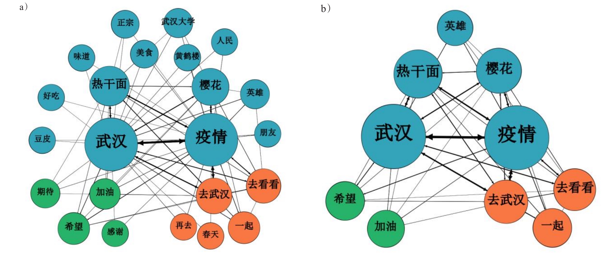
With the normalization of the coronavirus disease (COVID-19) pandemic, people are encouraged to stay at home as much as possible. This has deeply affected the tourism industry. The tourism market size is decreasing sharply, and the restoration of tourism destinations faces great difficulties. Wuhan, the first city to have fought the COVID-19 pandemic head-on, attracted all Chinese people's attention, as everybody said, "come on, Wuhan!" on social media and lent it great support in fighting the pandemic. People discussed the pandemic, became more aware about Wuhan, made plans to travel to Wuhan after the pandemic, and celebrated the stage victory when Wuhan was reopened, which constitutes a meaningful phenomenon in the tourism industry. To reveal the theoretical relationship between people's empathy and travel willingness, this article crawls the microblog data of Wuhan for one month before and after the reopening, from March 24 to April 23, and introduces the destination image as a mediator variable to reflect people's cognition about Wuhan. Then, the data are analyzed and the theoretical model is tested through qualitative and quantitative methods. The main conclusions are as follows: in the post-pandemic period, people's empathy toward Wuhan is dominated by positive emotions, accounting for 85.09% of responses. Respectively, neutral and negative emotions account for 3.42% and 11.49%, respectively. In addition to Wuhan's traditional image, "oriental cherry," "Wuhan hot-dry noodles," a specialty breakfast meal in the Hubei province, many new images of Wuhan have emerged, such as "hero" and "heroic," owing to its tenacious spirit and deep sacrifices during the pandemic. Generally, people have a strong willingness to travel to Wuhan, and the pandemic has transformed it into a special tourism attraction. Many inspiring emotions have emerged, such as "Wuhan," "come on," "hope," "pandemic," "definitely," "go again," and eat "Wuhan hot-dry noodles." According to the hypothesis model test results, empathy affects travel willingness significantly, however, the direct effect between empathy and travel willingness is completely mediated after the destination image is added, and its effect size is 0.191. In conclusion, the influence of empathy upon tourism willingness is fully implemented with the help of the destination image. Empathy between potential tourists and the destination produces emotional resonance, admiration, and other emotions. Such empathy spurs people's insight about the destination, produces a new destination image, and creates a strong travel willingness. This article clarifies why people travel to a specific destination after a public emergency. Additionally, the results suggest that it is necessary to guide the propagation of positive emotions, and consider the possible impact of emergency upon the destination image, by which the tourism industry may reach its revitalization after the pandemic crisis effectively. For Wuhan, it is a plausible approach to rely on people's empathy in the COVID-19 pandemic, and the new destination image can also stimulate people's travel willingness. Furthermore, many new tourism marketing activities based on the destination image may change, such as "come and enjoy the hot-dry noodles," "come and enjoy the oriental cherry again," and may play unique roles in the restoration of the tourism industry.
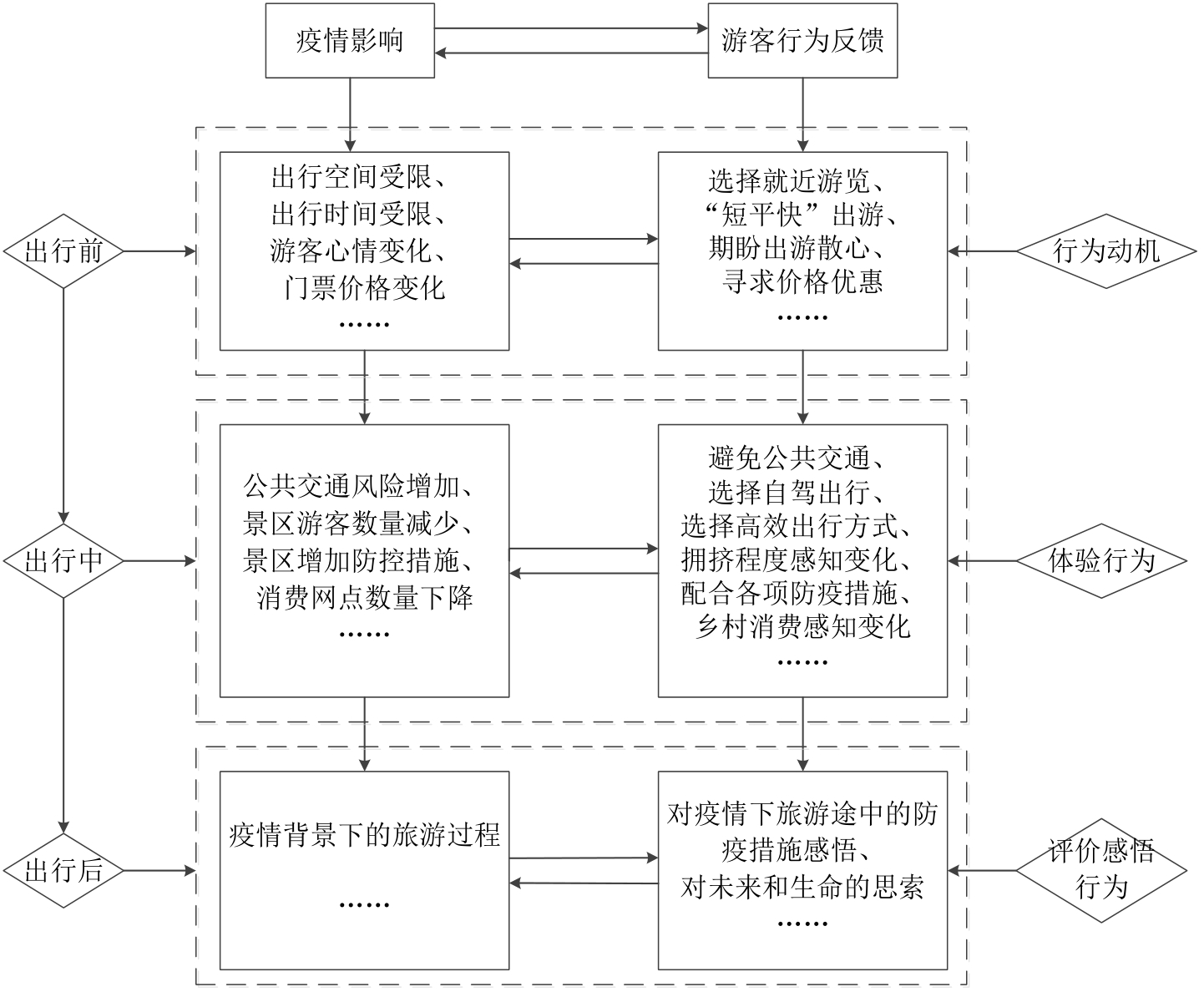
Tourism is a sensitive industry that is extremely vulnerable to crisis situations. The development of China's tourism industry was halted altogether after the massive outbreak of COVID-19 in early 2020. Entering the phase of normalization of epidemic prevention, rural tourism becomes the main force of tourism recovery. This study uses online travelogues to determine the behavioral changes of rural tourists before and after the occurrence of COVID-19. The study applies rooting theory and constructs a rural tourism behavior model based on the temporal logic of tourism progress. The following results were obtained: First, rural tourism behavior includes three stages (behavior motivation, experience behavior, and evaluation behavior), and its framework can be organized into four aspects (behavior time, behavior link, behavior content, and behavior level). Second, while the COVID-19 outbreak poses a serious impediment, it also brings development opportunities. Rural tourism, as the "dark horse" of tourism recovery speed, has obvious advantages. The vast space and good environment of the countryside in the post-epidemic era have become an ideal tourist destination for the urban population during the epidemic. Six rural tourism objectives emerged during the epidemic: epidemic suppression rebound, escape from the epidemic haze, the lure of ticket specials, search for safe areas, travel time constraints, and travel space constraints. Third, rural tourism's tourist experience behavior in the context of the epidemic presents a series of new features, including transportation choice behavior, perceived degree of congestion, and consumption behavior. Changes in the number of visitors to scenic areas, scenic management measures, and scenic consumption places can influence tourist behavior accordingly. Finally, owing to the specificity of the tourism experience process, its physical and mental contradictions and interaction mechanisms are systematic and complex. The contradictions between the need to travel during the epidemic and reality fiercely affect the emotions of tourists, whose emotional expression is more complex and adds a layer to the perception of life. Ultimately, the process of the tourism experience is reflected in the individual, thereby facilitating the visitor's satisfaction of self-growth and discovery. The novelty of this study lies in its research perspective, which takes tourist behavior as an entry point to explore the impact of the epidemic on the behavior of rural tourists from their point of view. The study findings can point to new directions for the tourism industry to achieve market recovery and industry revitalization after the epidemic and guide rural tourism destinations to better assess and respond to changes in tourism demand.