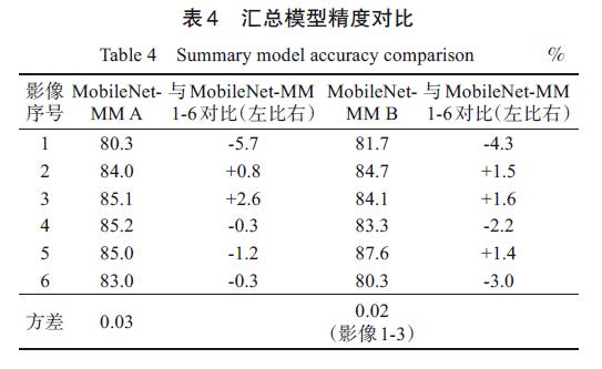
With the rapid growth of China's economy and the supportive government policies and funds, the demand for and the expansion of rural housing in China are on the rise, which tightens requirements for rural housing. However, most of the present rural housing suffers from unplanned growth. The sprawl of rural housing adversely affects the quantity and quality of land resources, in particular, productive agricultural lands; therefore, it is necessary to regulate the growth of rural housing and protect farmlands through spatiotemporally continuous monitoring. Currently, the monitoring of rural housing in China is mainly conducted via in-situ inspection of the national land survey, which is restricted by unfavorable conditions (e.g., weather, outbreaks, and traffic) as well as impairing real-time and reliable control over information collected. To resolve this issue, this study proposed an intelligent model to recognize rural housing in underdeveloped areas based on deep learning and mathematical morphology (MobileNet-MM). The model was based on high-resolution remote sensing data, MobileNetV2 (a convolutional neural network architecture well performing on mobile devices), and mathematical morphology. First, the obtained data were segmented and manually screened and tagged to construct a training dataset. Second, the training dataset was used to train MobileNet-MM, with the expansion operation being used to compensate for identification errors of deep learning. Finally, the accuracy of MobileNet-MM to identify and monitor rural housing was tested, resulting in 84.5% accuracy. The comparison of the accuracies of MobileNet-MM and ResNet34 (a state-of-the-art image classification model) indicated that ResNet34 misclassified a large area of rural housing that was mainly distributed on the edge of the region as well as cropland and vegetation as rural housing, with its weak ability to recognize actual rural housing. The MobileNet-MM model predicted rural housing accurately and land boundary precisely, with the misclassified area being scattered, and its average accuracy, is 10.6% higher than that of ResNet34. The novelties of this study were two-fold: (1) a high-resolution training dataset of rural housing in underdeveloped areas was generated, which provides data support for the development of subsequent models; and (2) an intelligent model to recognize rural housing in underdeveloped areas (MobileNet-MM) based on deep learning and mathematical morphology was proposed.
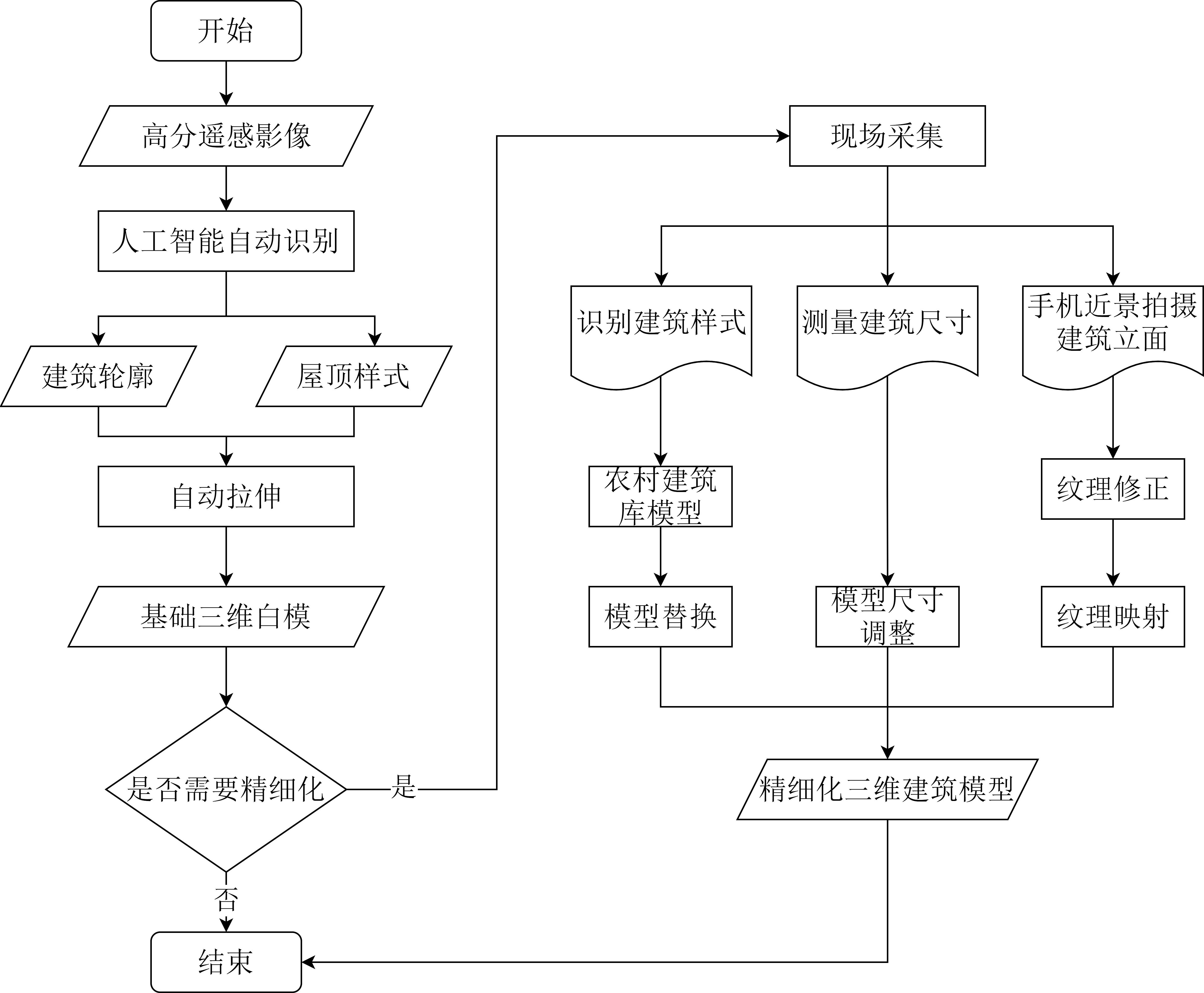
China's rural areas are vast, and housing construction is the primary organization of farmers' living spaces and an essential focus of the national implementation of rural revitalization. However, there is a lack of rural housing census data and methods that quickly and accurately establish a rural three-dimensional (3D)-building model. The existing 3D-building modeling techniques, including manual modeling and oblique photography modeling, are encountering the problem of high cost and do not meet the construction requirements of low cost and comprehensive coverage. With the development of satellite remote sensing technology in China, building recognition based on high-resolution remote sensing images has become a convenient and rapid technical tool. At the same time, with the widespread use of smartphones and their potent computing power, people can easily and quickly access the Internet and receive a three-dimensional display. Compared with two-dimensional products, three-dimensional products can show rural buildings, terrain, and landscape more clearly, enhance the refined management of rural areas, and improve enthusiasm to participate in rural construction. Therefore, this study proposes a simple rural 3D building modeling method based on multi-source data fusion, namely intelligent identification and 3D modeling for rural buildings. This method consists of two stages: rough model generation and deepening. In the rough model generation stage, the building is identified based on high-resolution remote sensing images and Mask R_CNN technology, the location of the building is determined, and the basic white model is obtained by stretching. In the deepening stage, field collectors replace the basic white model with a more refined and parameterized model based on the rural building model library, according to the actual situation. Subsequently, they supplement the building facade texture through smartphone photography and texture processing. Finally, a physical, storable, and exchangeable 3D-building model is obtained through coordinate matching, image terrain fusion, 3D-lightweight technology, and other technologies. This study adopts the modeling strategy of gradual deepening to reduce the modeling cost. The associated high-resolution remote sensing image recognition technology and mobile phone-based 3D modeling and display technologies are relatively advanced. Based on the characteristics of architectural styles in rural areas, a set of rural building-model libraries based on CSG technology was constructed. Model replacement, model size adjustment, texture mapping, and other operations were quickly used to build a refined 3D model. Finally, the 3D models were lightly processed and fused with the image topography and other data, which meets the demand for smooth browsing from various aspects. The 3D model of Hecun Village in Xinxing County was experimentally reconstructed, illustrating that the method can support applications such as rural surveys, rural planning, rural construction, and co-production. The modeling results show that the method is simple, easy to use, and reduces the high requirements of conventional modeling in terms of data acquisition and processing. It can provide a low-cost, highly efficient, and prevalent 3D-reconstruction method for rural regions, which is suitable for widespread promotion.
Ecological conservation red line is an important initiative for ecological civilization construction in China. Studies and works have been conducted to delineate the ecological conservation red line using remote sensing and manual survey methods. However, the traditional ecological assessment methods ignore the impact of dynamic elements on the ecological environment, and a permanent monitoring system for ecological conservation red line is still necessary. Therefore, this paper aimed to build a daily monitoring system of the ecological conservation red line from the perspective of ecological soundscape, combining deep learning and traditional Geographic Information System (GIS) methods. We analyzed the main factors affecting the ecological soundscape to provide a benchmark for selecting sites for permanent soundscape monitoring. Initially, this study developed the first classification standard of soundscape elements for daily monitoring of ecological conservation red line concerning the "ecological-production-living spaces" concept and existing literature on soundscape and built a deep learning model for training, with training and validation accuracies of 89.88% and 72.41%, respectively. The identification results of this model confirmed that the solution of intelligent monitoring through soundscape is reliable in daily monitoring. Then, the deep learning model was employed to classify and predict the soundscape collected from the case sites and effectively identify the areas with severe ecological encroachment by calculating the proportion of ecological soundscape elements, performing the simulation of daily monitoring, which is important guidance for the actual ecological conservation red line monitoring. Finally, a regression model was used to analyze the spatial characteristics of ecologically vulnerable areas, with an R2 of 0.472. The regression model showed that nighttime light intensity had the greatest influence on ecological soundscape, followed by the distance from residential areas, spatial centrality, and road distance. These factors should be considered when implementing permanent soundscape monitoring sites. In addition, Normalized Difference Vegetation Index (NDVI) and topography were not significant in the regression model, which confirmed the shortcomings of considering only the ecological background and ignoring the dynamic biological elements. Daily monitoring should capture dynamic encroachments so that major ecological damage can be detected before it occurs. Therefore, the innovative integration of soundscape elements into the monitoring system meets the basic needs of monitoring ecological conservation red lines daily.
Interest relationship is are the most basic among all social relations. In the field of urban renewal, the game process, conflict mechanism, and coordination mechanism among multiple stakeholders are important issues for cities to improve their sustainability. The stakeholders involved in the transformation of village-level industrial parks are more diverse, the interest differentiation is more frequent, and interest conflicts are more intense. The existing research mainly tries to explore the status quo, mode strategy and interest game in the transformation process of village industrial park from the aspects of power, system and space, and points out the importance of interest balance among "land stakeholders" such as government, market and property owners, but there are still deficiencies in the multi-subject participation mechanism and interest coordination mechanism. Due to the lack of advantages in location value, public finance and industry introduction, peripheral cities in the Pearl River Delta represented by Jiangmen are unable to ensure the positive guidance of spatial value remodeling and the full expression of diverse interests, resulting in slow progress of the reconstruction. Therefore, based on the stakeholder perspective of the urban regime theory, and constructing the multi-scale and multi-subject analytical framework of "stakeholder identification-interest conflict analysis-interest mechanism coordination,"the stakeholders in the upgrading of the village industrial park in Heshan City were investigated through a literature review, expert rating, and questionnaire interview. This study examines the practical problems of the village industrial park in Heshan City, Guangdong Province,to identify the stakeholders, interest demands, and conflicts involved in the transformation of the aforementioned. Subsequently, combined with typical park reconstruction cases, the interest game process of core stakeholders such as government departments, state-owned enterprises, private enterprises, financial institutions, village collectives, and villagers is discussed.Additionally, the evolutionary path and micro-mechanism framework of the formation of diversified interest alliances, the achievement of diversified goals, and the coordination of multi-subject interests are revealed in this process. Research shows the main constraints to the implementation of village-level industrial parks are the unequal power of stakeholders, unfair participation of power, unreasonable benefit distribution, and compensation mechanism. The participant-subjects and related capital input, source and income, collaborative transformation of industry and space, as well as the responsibility and power relationship of the implementation subject are more complex. In turn, government departments such as the Finance Bureau and the Bureau of Natural Resources are forced to form formal or informal partnerships with developers, enterprises and original owners. In the less developed areas of the Pearl River Delta, the mode of "government-led plusdiversified participation"is usually adopted. By entrusting full power to governmental financial organizations such as the Finance Bureau and the State-owned Assets Supervision and Administration Commission, village collectives and villagers are united with developers, operators, and financial institutions to form formal and informal cooperation relations, such as government-village and government-enterprise alliances, as well as interest distribution and incentive mechanisms. Additionally, the achievement of political, economic, social, and ecological diversification goals is promoted.Finally, this study proposes the following areas for future research: First, research on the micro behavior decision-making and mechanism of the village industrial park reconstruction can be conducted to further explore the "institutional space" of the reconstruction and its incentive and constraint mechanismto reveal the underlying"power-capital-space"and the political economic logic behind it. Second, against the background of multiple driving factors, there are also significant differences in the form, process, and mechanism of cooperation between the interest subjects of the village-level industrial park transformation. The differences in the main subjects in different modes, their temporal and spatial effects, and the mechanisms of action need to be further explored. Finally, the study investigates the social and cultural spatial response, governance path, and subject initiative of the village industrial park transformation, and reveals the possible ways in which village collectives and farmers' active social spatial practicescan improve their own situation through the logic of spatial governance.
A rural revitalization strategy has been proposed, and more attention has been paid to village planning, which has become an important measure to adjust to local conditions, implement policies accurately, and build a beautiful countryside. The core of rural revitalization involves planning first, promoting industry, serving the countryside, and planning the village as the unit. An important aspect of village planning is road planning and design, which is essential to further connect agricultural production, country living, and ecological space of the village; promote production; serve life; and strengthen traffic between the village and the external region. Owing to the differences in geographical and natural conditions and the level of economic development between urban and rural areas in China, village road planning cannot copy the previous methods of road route selection and urban road planning. Instead, it is necessary to explore a universal, efficient, and intelligent village road planning method that considers the actual situation of rural development by considering agricultural production, villagers' lives, industrial development, historical and cultural protection, and other factors. In the context of rural revitalization, this study takes the village as the planning unit, considers the natural environment, current layout, and development needs of the village, uses the qualitative and quantitative fuzzy analytic hierarchy process to analyze and quantify the natural, social, demographic and other factors of the village road planning and their weights, and uses the weighted superposition analysis method to form a comprehensive cost grid of the village with multiple elements. A process-based village road planning GIS tool is constructed, and the minimum cost path algorithm was used to automatically generate the village road network with the minimum comprehensive cost. Taking Gangtou Village in Huadu District of Guangzhou City as an example, the feasibility of the above methods, technical processes, and GIS tools was verified, and a village-wide comprehensive cost grid was efficiently generated. According to the five elements of residential areas, cultivated land, historical monuments, public facilities, and entrances and exits of external roads, five categories, seven starting points, and 16 ending points of village planning roads were automatically extracted, and a four-level village road from multiple starting points to multiple ending points was automatically generated, including four main roads with a width of 5-8 meters, two secondary main roads with a width of 3-5 meters, nine productive branch roads with a width of 2-3 meters, 13 living branch roads, and one village road. The results show that the village road planning method proposed here can efficiently generate multi-type and multi-level village roads, and the planned road network not only has a minimum construction cost but also good connectivity and practicability. The village road-planning method proposed in this study integrates natural, social, demographic, and industrial development factors and their characteristics, providing systematic ideas and automated methods for village road planning. This is helpful for promoting the intelligence of village road planning.
In the era of the digital economy, live-streaming of agricultural products has become a new means of rural revitalization, which not only promotes the transformation of the rural economy but also deepens the dual promotion of villagers' rights and identities. Based on the practice of rural women's participation in the live-streaming of agricultural products, this study discussed the extent to which the live-streaming economy reconstructed rural women's identities and reproduced their production and living spaces from the perspective of feminist geography. Based on a sampling of villages representative of Qianpai Town, Guangdong Province, this study unfolded the opportunities, processes, and effects of women's empowerment in rural spatial transformation through qualitative research methods, such as participatory observation, in-depth interviews, and discourse analysis. Findings of the present study included: (1) while the live-streaming economy was found in the rural area, not only were diversified resources, such as policy, education, material, and cultural support, brought to Qianpai Town, but also rural women who either originally worked in cities or engaged in agricultural production obtained their new empowerment power. (2) The empowerment of rural women was prominently manifested in the reconstruction process of women's identity during the practice of digital entrepreneurship. Owing to the development of the digital economy, rural women self-reconstructed their identity from "migrant workers" to "returning entrepreneurs" and from "knowledge receivers" to "culture communicators", showing that they could expand their way of livelihood by mastering the right of independent employment, as well as the expansion of women's social network and the prominence of their dominant position. (3) The rural reconstruction under the live-streaming economy was a complex and dynamic process in which rural production and living spaces, private spaces, and public spaces were intertwined. The "familiarization" of live-streaming places broke the boundary between women's production and living spaces and facilitated the economic transformation of home space and the socialization of private space, thus contributing to the reconstruction of production and living spaces in rural areas. Overall, the practice of women's digital entrepreneurship contributed to the enhancement of their sense of self-value and the reshaping of their roles at home and in society to raise their voice and status in the economic activities of the family. This study argued that the coupling of rural women and the "live-streaming economy" in the digitalization process of rural areas provides a new research ground for deepening the understanding of women's empowerment mechanism through digital technology and the evolving human-place relationship of rural China. The analysis presented contributes to the exploration of the rural transformation and development processes from the perspective of the interaction between "women" and "place" and provides actionable insights into rural restructuring. The results of this study help to better understand the effects and mechanisms of the live-streaming economy on rural women as well as on their production and living spaces, thereby presenting theoretical and practical insights into rural women's empowerment through digital technology.
The deepening of the social division of labor in economic development has led to the emergence of the logistics industry. The development of distribution plays an important role in optimizing regional resource allocation and improving regional competitiveness. The construction of logistics and distribution facilities not only promotes the upward movement of agricultural products but also the downward movement of industrial products, playing an important role in both the production and consumption sides, especially in rural areas. Existing logistics research based on the spatial perspective mainly focuses on the exploration of urban logistics and distribution, including the evaluation of urban logistics hubs and the construction of logistics systems, and so on. There is limited research on the evaluation of rural logistics and distribution level and its spatial characteristics. Moreover, in a comprehensive view, owing to the difficulty of obtaining logistics data in rural areas, the existing research lacks systematic and quantitative analysis on the layout of rural logistics and distribution facilities and their formation mechanisms. Therefore, this study explores the spatial distribution and clustering characteristics of e-commerce distribution levels in rural areas of China, as well as the influencing factors of rural logistics levels. Data are derived from the administrative village e-commerce distribution points from the third national agricultural census of 2016, and analytical methods such as spatial autocorrelation and ordinary least squares regression models are employed. The level of rural logistics displays a staggered distribution of high and low values, and some regions have homogeneous provincial distribution characteristics between high and low value areas; this is especially significant in Chinese provinces such as Hebei, Jiangsu, and Shandong. Overall, rural logistics distribution in all four major regions of China is at a low average level, but regional differences still exist at the geographic level, with high-high (H-H) agglomeration areas concentrated in the Yangtze River Delta and Bohai regions. The agglomeration phenomenon is particularly significant in Hebei and Zhejiang Provinces. The low-low (L-L) agglomeration area is mainly located in the Sichuan-Tibet region. From the spatial variation characteristics, the increase in the proportion of e-commerce distribution villages at the municipal level has more practical value than the increase in the number alone. Different factors have a differential impact on the level of rural e-commerce distribution construction in each region. Ethnic minority characteristics in the eastern region can enhance the level of rural e-commerce distribution, while ethnic characteristics in the central, western, and northeastern regions do not have a significant impact on the development of such facilities. The development of roads, public transportation, and other infrastructure in the central and western regions has a direct impact on the development of rural logistics and distribution. The more mountainous administrative villages, the worse the level of logistics and distribution construction, and the western and northeastern regions exhibit particularly significant performance. This study adds to the knowledge on the development level of China's rural logistics, helps promote the development of rural e-commerce, provides a solid foundation for the implementation of a rural revitalization strategy, and enhances the purposeful and scientific construction of rural distribution points.
China implemented a rural revitalization strategy in 2018 to promote the modernization of agriculture and rural areas. The modernization of rural dwellings is of great significance for rural modernization; however, only few studies have been conducted in the context of the modernization of rural housing in China due to the difficulties of obtaining data. Consquently, little attention has been paid to the current state of rural housing and perceptions of rural residents. This study was conducted to understand the current basic situation of rural housing in China and the satisfaction of rural residents with it and to analyze the factors that influence satisfaction. Using data from 2021, this study discussed the changes in rural housing in China and the current satisfaction of rural residents with their houses. We selected seven categories to measure the functional facilities of rural housing: electricity, pipe water, flush toilets, shower facilities, kitchens, gas, and the Internet. We analyzed modern changes in rural housing from the aspects of structure and function and residents' housing satisfaction. Furthermore, this study used an ordered probit model to analyze the relationship between these functions and rural residents' housing satisfaction. The following conclusions were drawn: 1) The current rural houses have been transformed from traditional to modern, and the housing conditions of rural housing have been improved. However, internal facilities are still relatively backward, especially in toilets and shower facilities. 2) Rural houses in different regions differ in their features and facilities. The building area of a single rural house shows spatial characteristics of high in the south and low in the north. The construction of the house was new in the west and old in the east. Flush toilets and shower facilities were the two facilities with the most regional differences, which were high in the south and low in the north. Kitchen and piped gas were high in the south and east and low in the north and west. 3) Rural residents' satisfaction with their rural housing was 3.7. The facilities of rural housing significantly affect rural residents' satisfaction, and personal characteristics, such as gender, age, and household income, are also important factors affecting satisfaction. Rural residents' perceptions of rural housing are shifting from a focus on newness and size to a focus on function and quality, which are mainly reflected in the demand for various facilities inside the house. Based on the findings of this study, we make the following suggestions: 1) For rural houses in poor condition, in addition to completing the identification and maintenance of housing safety, increased attention should be paid to functional facilities, especially for the improvement of flush toilets and shower facilities. 2) The government can provide assistance for the construction of rural houses, such as monitoring the qualifications of design and construction agents, providing specific guidelines and requirements for the construction of internal facilities of rural houses, and providing samples for reference. In the future, we should consider how to coordinate the construction of rural housing with infrastructure, such as water supply, drainage, and sewerage, and the construction of rural housing and villages should be closely integrated.
Implementing a rural revitalization strategy requires exploring a sustainable rural development path. Promoting sustainable rural construction has become an important issue that urgently needs to be solved. Sustainable countryside is a rural system that can continuously provide high-quality employment, housing, travel, medical care, education, pensions, communication, and other services for local rural residents. It can also continuously provide healthy agricultural products, good ecological products, and cultural tourism experiences for surrounding residents, including sustainable rural industry, sustainable rural environment, and sustainable farmers' lives. Sustainable rural construction is the goal and vision of the implementation for the rural revitalization strategy. This is conducive to solving the issues related to agriculture, rural areas, and rural people, narrowing the gap between urban and rural areas, and promoting the integration of urban and rural development. In recent years, rural revitalization work in Changsha (the capital city of Hunan Province) has been at the forefront of Hunan Province. In 2020, the total output value of agriculture, forestry, animal husbandry, and fishery in the city was 72,219.25 million yuan; the per capita disposable income of rural areas was 34,754.3 yuan, which is 18,169.7 yuan higher than the average level of the whole province; and the income ratio of urban and rural residents was 1.7, which is 0.8 lower than the average level of Hunan Province. Rural infrastructure and public services have been significantly improved, but at the same time, there are also many problems. Based on this, guided by the theory of sustainable development and the theory of the hierarchy of needs, this paper explains the connotation and system composition of sustainable villages in detail. Beginning with the elements of a sustainable rural system, this paper analyzes the common problems and individual characteristics faced by the sustainable development of rural areas in Changsha by means of statistical analysis, questionnaire surveys, and interview surveys. Finally, this paper presents a differentiated sustainable rural optimization model and implementation path based on the problem-solving orientation and the three core elements of a sustainable rural system. These are the lives of farmers, rural industries, and the rural environment. The objective is to provide a theoretical basis for the implementation of a rural revitalization strategy in Changsha City. The results show that there are common problems in the rural areas of Changsha City, such as the loss of the young and middle-aged labor force, weakening of the main body, lack of rural attraction, low quality of public service supply, lack of resilience, lack of endogenous motivation, and low general satisfaction of residents. In addition, individual problems are also prominent. For example, the tourism attraction of tourism-oriented villages is not strong, the agricultural machinery in agricultural villages is insufficient, the traditional cultural function of traditional villages has declined, and the industrial development foundation of general villages is weak. Therefore, this study proposes four targeted sustainable rural optimization models: ecological leisure tourism, efficient ecological agriculture, characteristic protection, and integrated development. The ecological leisure tourism model designs diversified rural tourism activities such as leisure, entertainment, vacation, experience, and education through the development concepts of ecology, low carbonization, and localization to continuously enhance the attractiveness of rural ecotourism. The efficient ecological agriculture model continuously improves the supply capacity of agricultural products and the function of the agricultural ecological landscape by using ecological and intelligent technology, promoting an organic combination of specialization, large-scale production, and small farmers' production. The characteristic protection model encourages the development of cultural tourism and related industries by relying on the countryside's unique historical and cultural heritage, combined with the unique resources of the countryside, such as rural pastoral scenery, agricultural experience activities, and an ecological environment. The integrated development model relies mainly on the resources of cities and surrounding villages and towns to play the leading role of cities and realize the joint development of villages and towns.
The rural revitalization strategy proposes to promote rural development based on a spatial governance and classification system. The development directions and foci of different types of villages show the characteristics of differentiation. Therefore, it is necessary to carry out accurate and precise studies on rural development to clarify the objectives and directions of rural revitalization by identifying the vitality and activation pathways of rural development. With a focus on 221 villages in Conghua District, the outer suburb of Guangzhou, this study quantified rural development vitality and rural multi-dimensional activation values based on the vitality index of rural development and the evaluation index of rural activation, respectively, derived from multi-source geospatial data and socio-economic statistics, classified activation types according to the methods of hierarchical assignment and combination matrix, and proposed the corresponding activation pathways. The results were three-fold. First, the vitality index of rural development verified by the multiple linear regression model accurately reflected the current course of rural development in the Conghua District in 2020. The proportion of rural areas at or below the middle vitality level of development was 62.89%, indicating that the rural development in Conghua District was lagging. It presents the spatial distribution characteristics of "cross". The villages at or above the high vitality level of development are close to the center of the town (street) where they are located, while low-level villages are mostly distributed in the west and north of Conghua District. Second, there existed a significant differentiation pattern of multi-dimensional activation value in the rural areas. The resource activation values remained at the lower level, while the production and life activation values remained at the middle level, and the ecological activation values remained at the excellent level. The comprehensive activation value was mainly at or above the middle level, with the villages accounting for 55.65%. In other words, Conghua District exhibited a large activation potential with a spatial distribution pattern of "high in the southwest and low in the northeast". Finally, the rural activation type mainly comprised the priority activation type (42.99%), close to the center of each town (street) in space and distributed in the south and west of Conghua District, followed by the ecological leading type (28.96%) and strengthened and upgraded villages (28.05%). The strategy of the priority activation type was to strengthen the integration of rural industries as well as the implementation of planning and design. The ecological leading type was mainly distributed in the north of Conghua District, with the activation direction to develop ecological rural tourism in harmony with environmental protection. Strengthened and upgraded villages were scattered in all towns (streets), with the activation focus on the rural property-leasing economy and the improvement of the transfer of agricultural land and living security. The results of this study can provide effective support strategies and scientific guidance for local governments to promote rural revitalization.
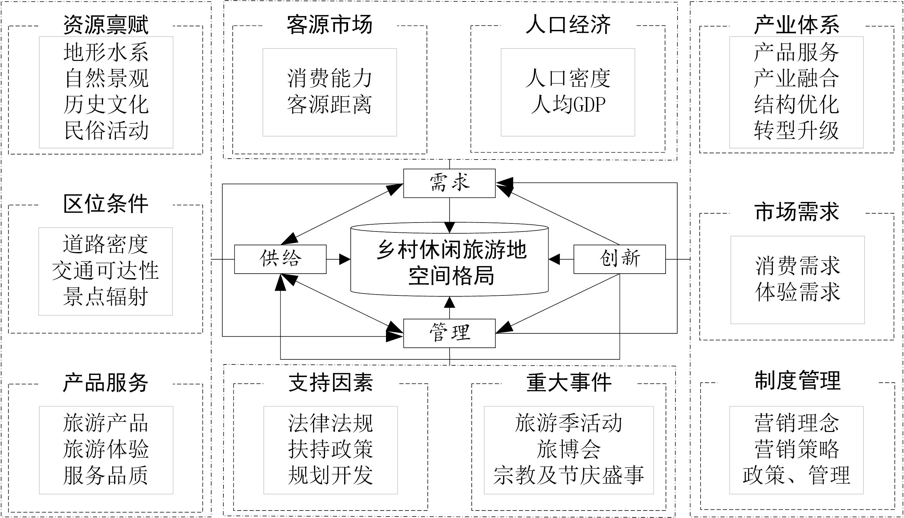
Rural leisure tourism plays a key role in promoting the development, revitalization, and industrial restructuring of rural areas. However, there exist only a few studies on the distribution patterns and influencing factors based on point-like leisure tourism villages. Therefore, this study analyzed the spatial distribution pattern of 650 rural leisure tourism sites, announced by the Department of Culture and Tourism of Guangdong Province, based on the methods of the nearest neighbor index, kernel density analysis, and Ripley's K-function in geographic information system technology. The influencing factors of spatial distribution characteristics were also explored by combining buffer zone, raster, and correlation analyses. The conclusions drawn were five-fold. First, the rural leisure tourism sites in Guangdong Province showed the spatial distribution of significant clustering with the overall pattern of "two axes and multiple growth poles". Second, based on the overall distribution along the border and coast, the distribution was evaluated according to the high and low nuclear density values and formed a relatively independent agglomeration of single-core or double-core. The spatial pattern analysis exhibited the significant spatial autocorrelation between rural leisure tourism sites and the pronounced differences between hot and cold regions. Third, the overall spatial distance of rural leisure tourism sites was 118.36 km, with the agglomeration degree showing a trend of "first increasing and then decreasing" as the spatial distance increased. The spatial distances of the characteristics of each type of rural leisure tourism site showed significant differentiation. The spatial distance of historical relics was the largest and showed a strong agglomeration in a large spatial range. The spatial distance of folk culture and village architecture was ranked second, being close to one another. Due to the limitation of their resource endowment and other factors, the spatial distance of the natural landscape and industrial integration was the smallest, showing pronounced scale dependency. Fourth, among the influencing factors, resource endowment, traffic accessibility, and attractive scenic area as the supply-side factors provided the basis for developing the layout of rural leisure tourism in Guangdong Province. Social economy and tourism market as the demand-side factors were the key influencers of the layout. Public policy support and development planning were the management factors that secured the layout development. Innovation factors promoted the renewal and development of supply, demand, and management levels as a way to encourage the transformation and upgrading of rural leisure tourism. The joint regulation of multiple factors in the four dimensions of supply, demand, management, and innovation contributed to the formation of the spatial distribution pattern of the rural leisure tourism sites in Guangdong Province. Finally, the study posed relevant suggestions derived from the present case study to provide the basis for the optimal resource allocation and layout for the rural leisure tourism sites in Guangdong Province.
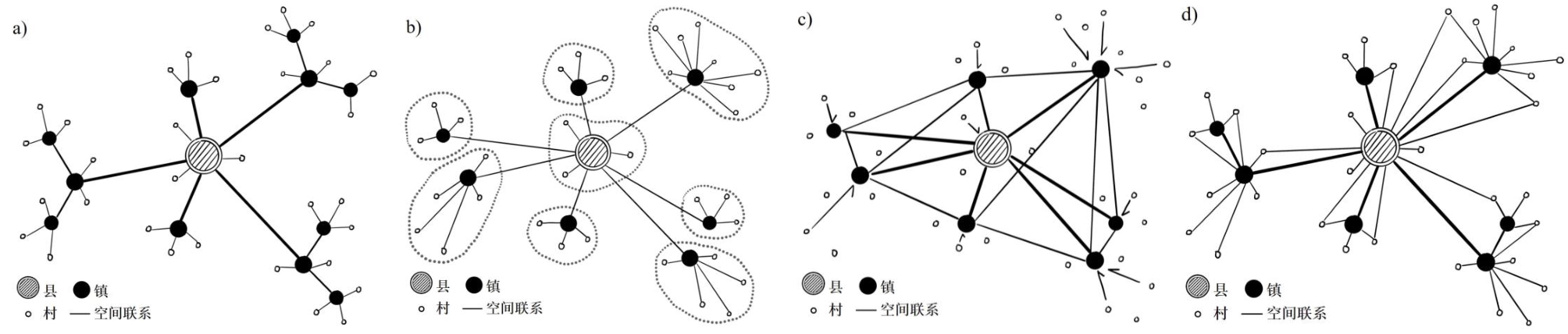
Since the launch of the Rural Revitalization Strategy, China's rural construction in county seats and villages has made remarkable achievements. Meanwhile, towns have received insufficient attention as a traditionally important node connecting urban and rural areas. Based on historical literature and the most recent survey of Yangxi and Wengyuan counties in Guangdong Province, this study examines how the relationship between county, town, and village changes over time as the functions of towns change. Data from field investigations and villagers' questionnaires obtained from the evaluation of rural construction by the Ministry of Housing and Urban-Rural Construction in 2021 regarding the two case towns were employed. This study analyzes the function and role of towns in the county-town-village system and further discusses the transformation of the spatial pattern of county-town-village in two case counties. The town has been transformed into a comprehensive functional service space, providing basic services such as daily shopping, preschool education, compulsory education, and basic medical care, and has regained its importance in connecting urban and rural areas in the "hierarchical and open network" spatial structure of county-town-village. As a service center radiating through the entire county, the county seat plays an essential central role in satisfying the rural population with higher-quality modern services in addition to basic services and offering non-routine service functions such as access to medical care and house purchases. According to the differentiated functions of different scales and the contextual geographic conditions in the two case towns, the pattern of county-town-village has diverted into two different spatial structures: the classic "central place" hierarchical and the county-central one. Geographical conditions still matter; in plain areas, transportation links between counties, towns, and villages are more convenient. Therefore, the service needs of villagers are the major influencing factor while they choose where to go. Moreover, a county seat with a stronger comprehensive service capacity is preferred, and the spatial pattern has higher centrality. In hilly areas, topographic barriers, and inconvenient transportation limits public service options. Fewer villagers choose to go directly to county seats owing to the inconvenience, instead, town as a medium space has attracted some village residents. Thus, the spatial pattern of hilly areas is less central and more in the "central place" hierarchical structure. In summary, this study brings town, as a research unit, back to researchers' attention, and demonstrates the shifting roles of towns in the new era. In addition to pursuing the full coverage of facilities, to achieve the rational allocation of resources in the construction of town seats, the study suggests that the demand scale and service threshold of different types of functions should be considered. Meanwhile, the county should be viewed as an inclusive unit that can coordinate the allocation of resources to towns according to their basic conditions. Based on a complete configuration of necessary facilities, towns near urbanized areas can make full use of the radiation capacity of the county or city and reduce the construction of overly urbanized facilities; in areas where transportation within the county is less convenient, the service level of towns needs to be further improved.
With the continuous advancement of urban renewal, innovative and creative spaces in the urban village have attracted much attention as a new model of space restoration. In the process of material space transformation, the emotional identity and place identity of innovative and creative spaces in urban villages are reconstructed. However, communities and residents in the urban village remain often been neglected in previous studies, most of which focused on the material and economic perspectives. In other words, the emotional mechanisms and spatial influences of relevant subjects in innovative and creative spaces have not received sufficient attention. By focusing on the innovative and creative spaces of Huangpu village in Guangzhou as an example, this study employed in-depth interviews, network text analysis, and other methods to explore the impact of innovative and creative spaces on residents' sense of place and their role in creating a local emotional identity within the context of urban renewal from the perspective of emotional geography. The innovative and creative spaces of the urban villages exerted a different impact on the local emotion and space identity of multiple subjects through the reshaping of the material environment, culture, and social relations. The improvement of the material environment of the innovative and creative spaces in the urban villages enhanced the emotional identity and local attachment of residents. The cultural values of modern industrial forms were not able to shape the local and cultural identities of residents but increased the level of makers. The local identity of the tenant group was based on creativity and cultural atmosphere. The innovative and creative spaces of the urban villages formed a social network relationship with industry as the link by strengthening the interaction and connection between the subjects, establishing a common emotional attachment and local identity, and transforming the original traditional living space into a multi-dimensional space with consumption, production, and leisure attributes. The emotion and atmosphere of the innovative and creative spaces were displayed during the interaction between makers and residents and during the production of creative products and made different subjects participate in the process of space-remodeling. Not only did this process strengthen the perception and recognition of innovative and creative elements and rural areas, but it also established the recognition of a common local value. Given the current emphasis on the reuse of stock space resources, such as industrial heritage and historical buildings, it is particularly important to focus on the emotional connection between humans and the environment. From the perspective of emotional geography, it is of great significance that the emotional effect and meaning of constructing innovative and creative spaces on rural development are elucidated. This study provides not only a theoretical perspective for a deeper understanding of the relationship between the innovative and creative spaces and the locality of urban villages but also insights into promoting culturally oriented urban renewal.

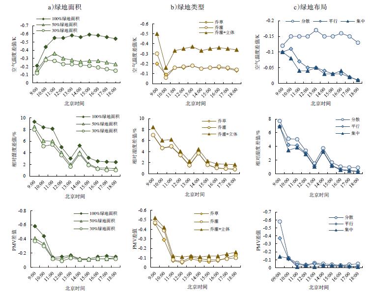
This study used the historical and cultural block of Taiping Street in Changsha as the research object. First the current microclimate environment of the street space was analyzed, then numerical simulations based on ENVI-met software were performed, which compared the microclimate numerical simulation results of three typical greening optimization schemes of the street space in the study area and the benchmark scheme, as well as explained the degree of thermal environment control of the greening optimization scheme. This study is expected to provide a reference for the reconstruction of urban historical blocks as well as optimization and control of the thermal environment. The results showed that: 1) With an hourly change in solar radiation, the thermal environment changed considerably, and the horizontal spatial distribution was characterized by "high temperature and low humidity" and "low temperature and high humidity." Thermal comfort is related to the underlying surface conditions, wind environment, building layout, and other factors. The low temperature and high humidity of the area with relatively concentrated green space along street spaces had a slow-release effect on the thermal environment. The ventilation effect of the area with the dense building layout was poor, and the thermal radiation of the underlying surface was high, affecting the heat dissipation and humidification in the research area. 2) The enclosed space layout of buildings in the study area caused building shadows and poor ventilation to affect the green space, which was not conducive for cooling and humidification. 3) Three types of greening transformation schemes were proposed for the street spaces of three different architectural layouts in the historical block of Taiping Street. The three kinds of street space green space optimization and benchmark schemes (the current street space situation) were simulated using ENVI-met microclimate simulation software. Optimization results showed that the same greening optimization scheme had different regulatory effects on the thermal environment in different building layouts. The three kinds of street spaces significantly reduced the average radiation temperature of the block by increasing the greening area of the block. The optimal regulatory effect of the thermal environment of the tree-shrub+three-dimensional (water) compound green space type was better than that of the tree-shrub and tree-grass scheme in the daytime. Under a certain green space ratio, the area of shade generated by the uniform and decentralized layout of green space in a commercial space covered the largest range of street space. The order of the degree of thermal environment optimization and control was decentralized>parallel>centralized. The residential and square spaces were affected by the architectural layout, and the green space layout should have good ventilation, cooling, and humidification effects; therefore, the maximum degree of thermal environment optimization and control is the centralized layout.
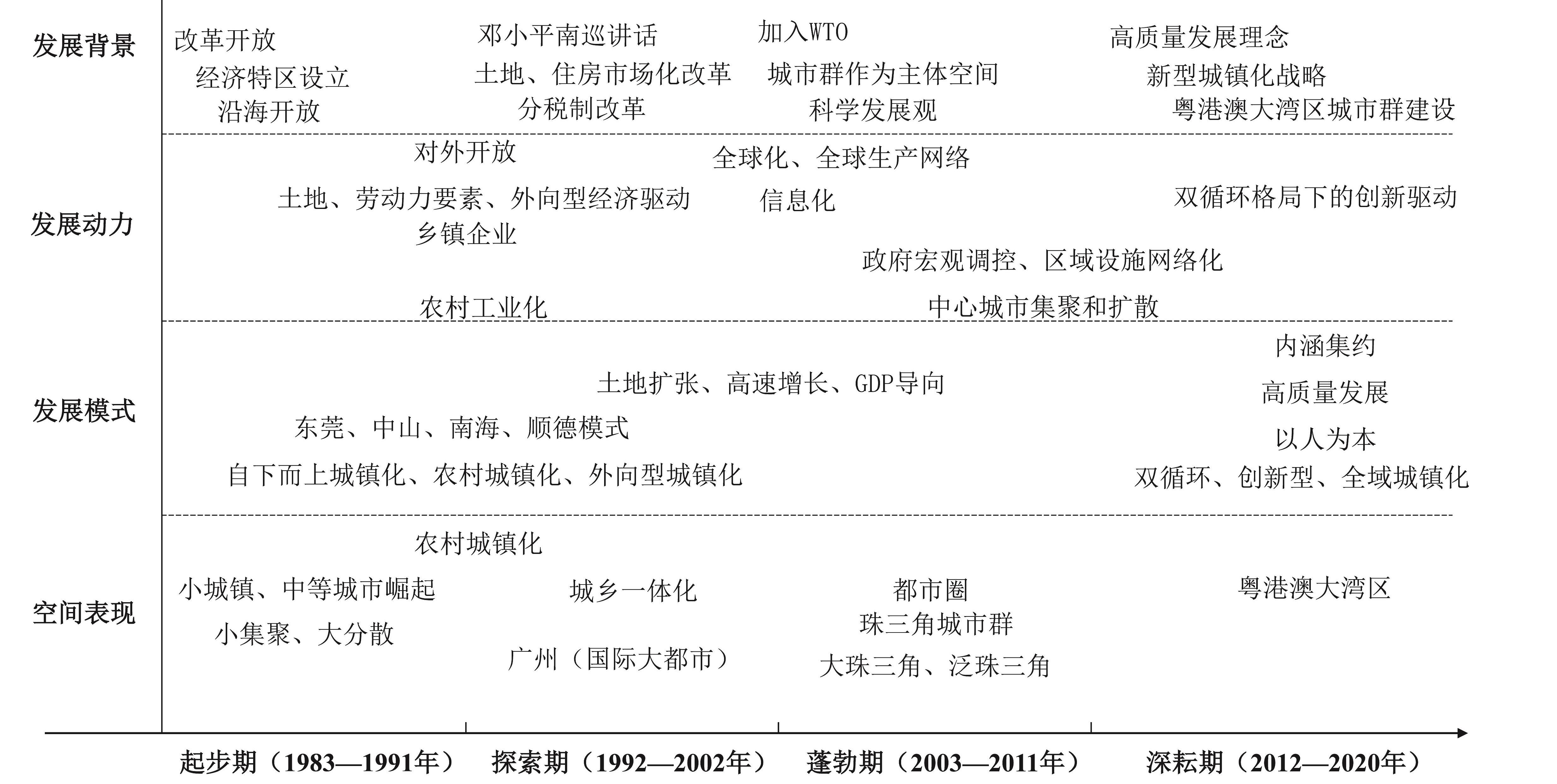
Pearl River Delta is the most densely populated and urbanized area in China. As the pilot area of reform and opening up, Pearl River Delta takes the lead in its urbanization in China and represents the development trend of China's urbanization. Therefore, a great number and diversity of previous studies on urbanization in the Pearl River Delta warrant further review and reflection. This study focused on publications about urbanization in the Pearl River Delta from 1983 to 2020 in the collection of Chinese core journals and dissertations in the China Academic Journals Full-text Database (CNKI). The quantitative characteristics of published papers, the scientific cooperation network of core authors and institutions, research topics, and historical research hotspots were analyzed for different periods through bibliometrics and mapping knowledge domains based on CiteSpace. Results indicated that: (1) the number of publications of the relevant research showed an upward trend, which was divided into the following four stages: initial (1983-1991), exploratory (1992-2002), prosperity (2003-2011), and deep cultivation (2012-2020) stages. (2) The research institutions gradually expanded from south China universities, with Sun Yat-sen University emerging as the core to form a national network of research collaboration, and the scholar network has expanded from occasional collaboration to form a variety of cooperation networks within and across institutions. (3) In the evolution process of knowledge, research topics that scholars focused on included economic zone, rural urbanization, urban agglomeration, Guangdong-Hong Kong-Macao Greater Bay area, new-type urbanization, innovation, while other historical hotspots that scholars focused on included economic zone, new-type urbanization, and Guangdong-Hong Kong-Macao Greater Bay area. (4) The research showed the characteristics of policy and practice orientations, the continuous expansion of vision and scope, and the theoretical research stages evolving from lag to advance and then to synchronization. After the urbanization development stage of a metropolitan circle and urban agglomeration was jointly entered, the theoretical construction of localization was slightly insufficient, and that of the people-oriented urbanization mode was lacking. (5) Pearl River Delta entered the regional urbanization stage, with the metropolitan areas and urban agglomerations being the main body. The driving force of urbanization development shifted to scientific and technological innovation, while the development features shifted to intensive, high-quality, and people-oriented urbanization. Finally, this study argued that future studies on urbanization in Pearl River Delta should focus on the theoretical and practical pathways of the coordinated development of urban agglomeration in the Guangdong-Hong Kong-Macao Greater Bay area, innovation-driven development strategy, and people-oriented urbanization.