
广州主城区建筑组合的类型、空间分布与影响因素
|
沈子桐(1996―),男,河南驻马店人,硕士,研究方向为城市空间结构、城市风环境,(E-mail)szt06392@163.com; |
收稿日期: 2020-11-10
修回日期: 2021-06-05
网络出版日期: 2021-06-30
基金资助
国家自然科学基金项目(41771001)
广州市产学研协同创新重大专项(201704020136)
The Types, Spatial Distribution, and Influencing Factors for Building Combinations in Guangzhou's Main Urban Area
Received date: 2020-11-10
Revised date: 2021-06-05
Online published: 2021-06-30
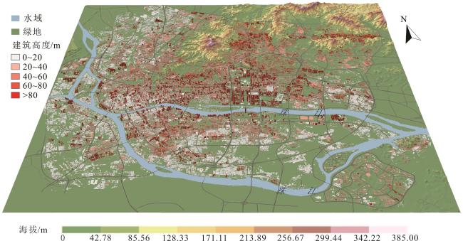
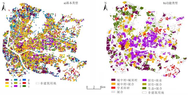
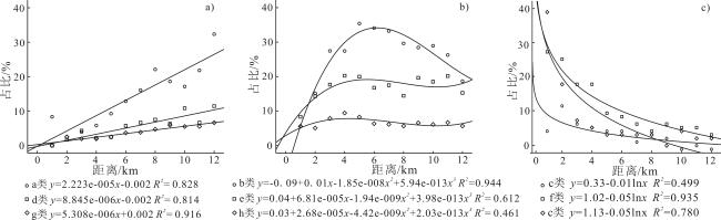
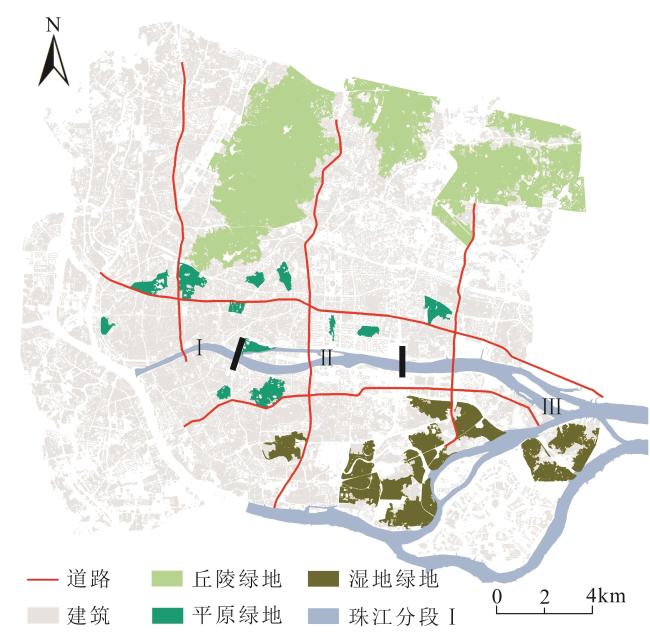
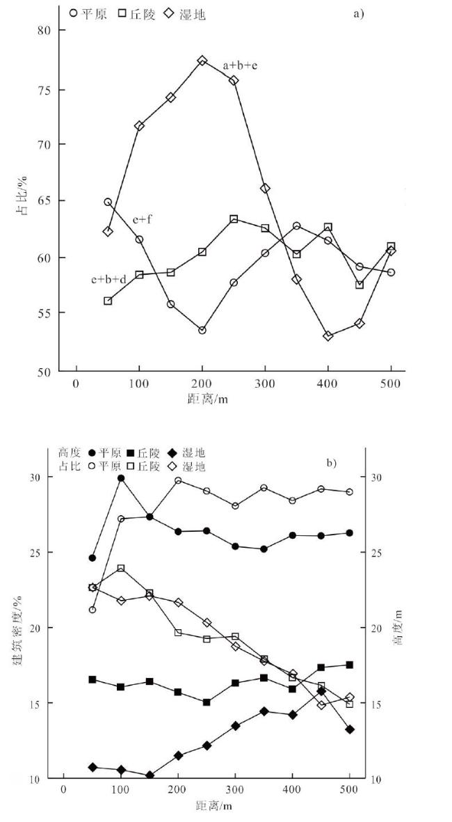
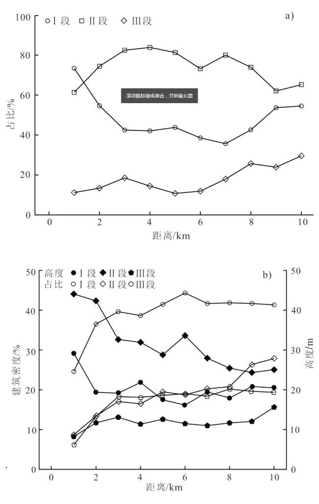
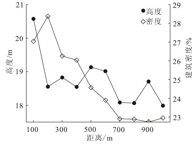
基于2017年广州市单体建筑数据,以建筑高度和建筑间距2个指标,确定主城区基本的建筑组合,利用热点分析辨识更高尺度上的建筑组合,在此基础上分析广州建筑组合的空间分布及其影响因素。主要结论有:1)建筑组合有9种基本类型,4 272斑块数量与面积在占比上具有很强的同步性。2)百米尺度斑块构成了主城区建筑组合的基本单元,并以混合用地类型为主,由高层建筑组成的类型用地功能指示作用明显。3)主城区基本类型圈层分布特点突出,各类型圈层分异规律存在差异。4)地价是城市建筑高度、人口密度由中心向外递减的核心制约因子,是城市建筑组合分异的宏观背景因素,并能在平原地形上很好地以圈层形式呈现出来。在百米尺度上,绿地、珠江与主干道在微观层面对建筑组合类型、高度和密度产生影响,使得主城区建筑组合复杂化、多样化。
沈子桐 , 孙武 , 孙靓 , 乔志强 , 朱琳琳 , 欧阳睿康 , 陈翔 . 广州主城区建筑组合的类型、空间分布与影响因素[J]. 热带地理, 2021 , 41(3) : 540 -553 . DOI: 10.13284/j.cnki.rddl.003349
The study of urban building combinations is necessary to achieve sustainable urban development, as through such a study we can better grasp the process of urban development and evolution, guide the direction of future urban development, optimize the urban ecological environment, and improve urban livability. With the acceleration of China's urbanization process, the development and evolution of building combinations in China's urban areas are also gaining momentum. Therefore, it is of tremendous practical use to explore the laws related to mixed developments in urban areas to guide rational urban planning and the study of urban microclimates. The analysis is an important foundation for the development of urban landscapes and provides important scientific support for the optimization of the urban ecological environment and the improvement of livability levels. From the data on individual buildings in Guangzhou in 2017, this paper determined basic building combinations in the main urban area using two indexes for building height and building spacing, identified building combinations on a wider scale using a hot-spot analysis, and analyzed the spatial distribution of building combinations and the influence of macro and micro factors. Nine building combinations were identified on the basis of average height and spacing of building convergence surface. As the basic units, the nine basic types were further divided into different combinations to form complex and diverse three-dimensional representations of buildings in the main urban area. Building convergence surface with a scale of hundreds of meters constitute the basic unit of building combination in the main urban area, and are dominated by mixed land use types. The basic types, mainly composed of high-rise buildings, played an obvious role in indicating land use with differences in combinations of each functional area. The basic types of main urban areas have prominent circle differentiation, but the laws for the different types differ. Land price was the core constraining factor for the decrease in urban building height and population density from the urban center to the periphery, as well as the background factor related to differences in urban building combinations. The influence of green spaces, the Pearl River, and the main road on the type, height, and density of the building combination at a micro level complicated building combinations.


表1 2017年500 m格网建筑物理属性间的相关性Table 1 Correlation between physical properties of500 m grid in 2017 |
| 建筑属性1 | 建筑属性2 | 相关性 |
|---|---|---|
| 建筑密度 | 建筑高度 | -0.03 |
| 建筑密度 | 最高高度 | 0.28** |
| 建筑密度 | 高度离散度 | 0.11** |
| 建筑密度 | 算术高度 | -0.08** |
| 建筑高度 | 最高高度 | 0.60** |
| 建筑高度 | 高度离散度 | 0.62** |
| 建筑高度 | 算术高度 | 0.87** |
| 最高高度 | 高度离散度 | 0.84** |
| 最高高度 | 算术高度 | 0.33** |
| 高度离散度 | 算术高度 | 0.32** |
|
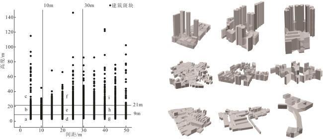
表2 基本类型的物理属性Table 2 Physical properties of basic types |
| 基本类型 | 斑块 | 面积 | 高度/m | 体积占比/% | 单点建筑面积占比/% | ||||
|---|---|---|---|---|---|---|---|---|---|
| 数量/个 | 占比/% | 平均面积/m2 | 占比/% | ||||||
| 间距≤10 m | a | 549 | 13 | 27 012.00 | 15 | 6.32 | 7 | 89 | |
| b | 649 | 15 | 29 011.80 | 18 | 13.30 | 18 | 88 | ||
| c | 71 | 2 | 25 654.95 | 2 | 29.00 | 4 | 91 | ||
| 10 m<间距<30 m | d | 502 | 12 | 22 167.77 | 11 | 7.10 | 5 | 75 | |
| e | 1 085 | 25 | 24 895.11 | 26 | 16.22 | 26 | 71 | ||
| f | 404 | 10 | 23 147.16 | 9 | 32.29 | 18 | 71 | ||
| 间距≥30 m | g | 268 | 6 | 17 948.95 | 5 | 7.22 | 2 | 59 | |
| h | 426 | 10 | 19 287.86 | 8 | 17.08 | 7 | 59 | ||
| i | 318 | 7 | 19 695.31 | 6 | 43.26 | 13 | 63 | ||
表3 平面形态特征Table 3 Plane morphological characteristics. |
| 基本类型 | 平均矩形度 | 平均圆度 | 平均扁度 |
|---|---|---|---|
| 均值 | 0.485 | 0.190 | 0.387 |
| a | 0.595 | 0.218 | 0.357 |
| b | 0.552 | 0.169 | 0.357 |
| c | 0.591 | 0.257 | 0.336 |
| d | 0.468 | 0.182 | 0.415 |
| e | 0.442 | 0.135 | 0.387 |
| f | 0.441 | 0.119 | 0.401 |
| g | 0.431 | 0.245 | 0.417 |
| h | 0.431 | 0.214 | 0.403 |
| i | 0.417 | 0.173 | 0.411 |
表4 基本类型在各功能区的面积占比Table 4 the proportion of basic types in each functional area % |
| 基本类型 | 商业 | 城中村 | 城郊村 | 学术科研 | 居住 | 工业 | 混合 | 生态 | 老城区 |
|---|---|---|---|---|---|---|---|---|---|
| a | 6.3 | 17.73 | 18.62 | 4.9 | 2.5 | 7.6 | 24.91 | 12.5 | 5.0 |
| b | 10.4 | 14.32 | 7.6 | 4.6 | 6.9 | 9.4 | 28.21 | 10.83 | 7.8 |
| c | 28.71 | 5.1 | 0 | 6.2 | 24.12 | 1.0 | 16.13 | 9.2 | 9.7 |
| d | 7.0 | 9.7 | 8.1 | 4.7 | 1.5 | 19.43 | 25.11 | 24.22 | 0.4 |
| e | 8.2 | 5.7 | 2.9 | 12.13 | 17.32 | 9.4 | 29.81 | 10.6 | 4.0 |
| f | 16.53 | 4.4 | 0.5 | 13.8 | 30.11 | 2.8 | 21.42 | 6.2 | 4.2 |
| g | 8.7 | 6.1 | 6.5 | 11.4 | 5.5 | 16.53 | 19.22 | 25.41 | 0.7 |
| h | 5.9 | 3.1 | 2.9 | 27.71 | 10.1 | 8.2 | 23.82 | 17.33 | 0.9 |
| i | 23.12 | 6.1 | 0.9 | 10.6 | 26.61 | 4.0 | 17.93 | 7.7 | 3.2 |
|
表5 热点聚类类型组合的物理性质Table 5 The physical nature of type combination of the hot spot cluster |
| 类型组合 | 数量/个 | 数量/% | 平均面积/m2 | 面积占比/% | 前三位 | 前三位面积占比/% | 高度/m | 单点建筑面积占比/% |
|---|---|---|---|---|---|---|---|---|
| 城中村+城郊村 | 94 | 7 | 191 183.35 | 14 | a+d+b | 81 | 7.83 | 69 |
| 城中村+混合 | 65 | 5 | 200 301.62 | 10 | b+e+a | 83 | 14.49 | 68 |
| 混合 | 591 | 46 | 81 001.05 | 37 | e+b+a | 61 | 15.19 | 64 |
| 居住+混合 | 80 | 6 | 113 857.57 | 7 | e+b+f | 83 | 17.65 | 60 |
| 居住+商业 | 223 | 17 | 107 857.23 | 19 | f+e+i | 77 | 28.58 | 58 |
| 生态+混合 | 104 | 8 | 115 960.20 | 9 | d+a+e | 79 | 8.66 | 63 |
| 学术科研 | 127 | 10 | 43 153.39 | 4 | h+e+a | 76 | 15.41 | 62 |

1 广州市规划和自然资源局.关于公布广州市2018年城镇国有建设用地标定地价成果的通告. http://ghzyj.gz.gov.cn/ywpd/tdgl/djxx/bddj/content/post_4936111.html。
|
|
|
|
|
|
|
卜心国,王仰麟,吴健生.2008.深圳快速城市化中地形对景观垂直格局的影响.地理学报,63(1):75-82.
|
|
陈探,刘淼,胡远满,常雄凯,李春林,徐岩岩,施拓.2015.沈阳城市三维景观空间格局分异特征. 生态学杂志,(9):243-249.
|
|
|
|
冯娴慧,魏清泉.2006.基于绿地生态机理的城市空间形态研究.热带地理,26(4):344-348.
Feng Xianhui and Wei Qingquan. 2006. A Study of the Urban Spatial Form Based on the Ecological Principles of Green Space. Tropical Geography, 26(4): 344-348.
|
|
冯章献,王士君,金珊合,杨俊.2019.长春市城市形态及风环境对地表温度的影响.地理学报,74(5):902-911.
|
|
|
|
葛珊珊.2009.基于Urban DEM的城市三维形态研究——以南京老城区为例.南京:南京师范大学. [Ge Shanshan. 2009. Three-Dimensional Urban Morphology Research Based on Urban DEM: Take the Old Urban Area of Nanjing as an Example. Nanjing: Nanjing Normal University. ]
|
|
何舒慧. 2019. 广州市主城区商业空间集聚特征研究. 广州:华南理工大学.
|
|
|
|
|
|
|
|
|
|
李大全,孙武,欧阳睿康,黄盛,高梦媛,李庆祥,黄启明.2019.湍流度随高度的变化及其对城市宏观地形的依赖.热带地理,39(3):365-376.
|
|
廖江福,唐立娜,邱全毅,许通,钱瑶.2015.海湾型半城市化地区空间形态演化模拟.热带地理,35(1):61-69.
|
|
罗谷松,孙武,李国,纪芸,王义明.2008.广州建成区三维城市模型的构建及其高度分布特征. 热带地理,28(6):523-528.
|
|
|
|
|
|
|
|
邱坚坚,刘毅华,袁利,陈澄静,黄清瑶.2020.粤港澳大湾区科技创新潜力的微观集聚格局及其空间规划应对.热带地理,40(5):808-820.
|
|
|
|
|
|
|
|
史北祥,杨俊宴. 2019. 基于GIS平台的大尺度空间形态分析方法——以特大城市中心区高度、密度和强度为例. 国际城市规划,34(2):111-117.
Shi Beixiang and Yang Junyan. 2019. Large Scale Spatial Morphology Analysis Method Based on GIS Platform: Take the Height, Density and Intensity of the Metropolitan Central Districts as Example. Urban Planning International, 34(2): 111-117.
|
|
孙斌栋,刘倩倩,张婷麟. 2018. 中国市域空间结构的特征及其影响因素. 地理科学,38(5):672-680.
|
|
孙武,李国,李涛,陈世栋,陈东梅,蒋海荣.2013.民国时期广州市建成区主体建筑立体形态的恢复及其特征.热带地理,33(5):518-526.
|
|
田峰,李虎.2017 联合星载光学与SAR图像的城市大面积建筑物高度快速提取.测绘学报,46(7):891-899.
Tian Feng amd Li Hu. 2017. Fusion of Spaceborne Optical and SAR Images for Building Height Quick Extraction in Big Urban Areas. Acta Geodaetica et Cartographica Sinica, 46(7): 891-899.
|
|
|
|
王珏晗,周春山.2018.广州市商业型健身房空间分布及其影响因素.热带地理,38(1):120-130.
Wang Yuhan and Zhou Chunshan. 2018. Spatial Distribution and Its Influential Factors of Commercial Fitness Clubs in Guangzhou. Tropical Geography, 38(1): 120-130.
|
|
魏立华,丛艳国,李志刚,闫小培. 2007. 20世纪90年代广州市从业人员的社会空间分异. 地理学报,62(4):407-417.
|
|
温锋华,李立勋. 2010. 广州市商务办公空间区划及其功能分异研究.热带地理,30(5):528-533.
Wen Fenghua and Li Lixun. 2010. Research on the Division and Functional Differentiation of Commercial Office Space in Guangzhou. Tropical Geography, 30(5): 528-533.
|
|
乌敦,阿拉腾图娅,木希叶乐.2019.基于GIS的呼和浩特市近百年街道时空演变及其特征分析.地理科学,39(6):987-996.
|
|
|
|
杨忍. 2019. 广州市城郊典型乡村空间分化过程及机制. 地理学报,74(8):1622-1636.
|
|
张平成. 2017. 基于多源数据的广州市主城区多中心空间格局解析. 广州:华南理工大学.
|
|
周春山,刘洋,朱红.2006.转型时期广州市社会区分析.地理学报,61(10):1046-1056.
|
/
| 〈 |
|
〉 |