
基于地缘关系的“海上丝路”沿线港口区位优势度评价
|
郭建科(1980—),男,山西长治人,教授,博士,主要从事区域海洋经济与空间规划、港口航运网络与交通地理、海洋地缘经济等科研与教学工作,(E-mail)gjianke98@126.com; |
收稿日期: 2022-07-31
修回日期: 2023-04-22
网络出版日期: 2023-08-14
基金资助
国家自然科学基金项目——“开放进程中港口区位优势度变迁的系统识别及其重塑机理”(41871112)
Evaluation of the Port Location Advantage Degree along the Maritime Silk Road Based on Geographic Relationships
Received date: 2022-07-31
Revised date: 2023-04-22
Online published: 2023-08-14
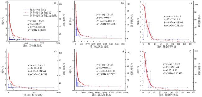
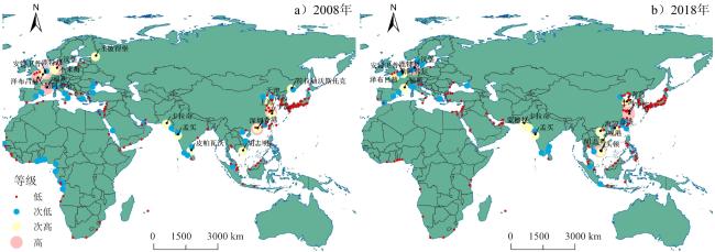
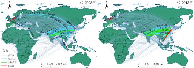
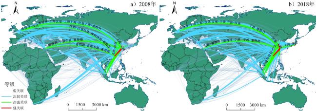
从港口联系出发,综合港口的地缘关系相关要素,以2008、2018年“海上丝路”沿线港口为对象,对沿线港口的区位优势度展开评价。研究发现:1)港口区位优势度也呈现一定程度的无标度特征,通过对港口间地缘关系的量化表达,发现在国际经贸往来中处于不同相对地位的腹地经济所赋予港口的重要性得以凸显,以中国为代表的亚洲新兴经济体普遍呈现较高水平的区位优势度;2)港口间的区位联系强度基本遵循距离衰减定律,区位联系重心向亚洲转移,反映随着亚洲诸多新兴经济体的发展,以亚洲为主导的港口区位联系格局逐渐形成;3)通过与主流的复杂网络指标的对比发现,尽管全球化时代“流空间”下形成要素流动的集中化,但诸如地缘关系、空间距离等基础的地理属性仍保持其独立性,未在全球产业与贸易的重构的影响下而呈现空间不均衡,港口区位优势度将保持较稳定的格局分布。基于地缘关系的港口区位分析可有效补充港口在航运网络区位联系的不足,对于揭示港口在国际航运网络中的区位稳定性具有重要意义。
郭建科 , 冯天琪 , 秦娅风 , 刘晓扬 . 基于地缘关系的“海上丝路”沿线港口区位优势度评价[J]. 热带地理, 2023 , 43(8) : 1652 -1664 . DOI: 10.13284/j.cnki.rddl.003727
As the most significant international transportation infrastructure, the operation and external links of ports are affected by more complicated aspects, resulting in immense changes not seen in a century. Related studies have long been interested in and have followed the evaluation of port location advantage as a comprehensive response to ports' economic and trade conditions. Location advantage reflects the overall resource advantage of a location. Transportation infrastructure can be evaluated from various perspectives, and the choice of different indicators sets the evaluation slant for its use. A port's ability to operate depends on natural navigational conditions, high-quality infrastructure, an appropriate economic hinterland, favorable geographic relationships, and a global environment. Port location advantage has traditionally been focused on from the perspective of transportation routes, hinterland economy, etc. The geographical proximity of nations also has a significant impact on how ports function in today's complex international development environments. To evaluate the advantages of port location along the route, this study uses the geo-relationships between various countries as well as the physical, functional, and economic links between ports as its research objects. It then homogenizes the national-scale WGI Global Governance Index to ports and incorporates it with port-scale maritime distances and route linkages as an integrated model of the degree of location advantage of the ports, using ports along the Maritime Silk Road from 2008 to 2018 as case studies to show how much the ports' advantage in location affects their significance in the real world international environment. The research findings are as follows. 1) Because of the relative position of the hinterland economy in international economic and trade exchanges, the port location advantage also exhibits some scale-free characteristics, and the quantitative expression of geo-relationships between ports emphasizes the importance of ports. As a representative of Asia's emerging economies, China has added more ports with more significant location advantages. 2) The strength of location connections between ports follows the law of distance attenuation, and the shift in the center of gravity of port location connections to Asia reflects the formation of a port location connection pattern dominated by internal Asia with the development of many emerging economies therein. 3) Comparison with mainstream complex network indicators found that although the concentration of factor flow has been formed under the "flow space" in the era of globalization, primary geographical attributes such as geographical relationships and spatial distance still maintain their independence and do not exhibit spatial imbalance under the influence of the reconstruction of global industries and trade. The location of ports based on geographical relationships and port location dominance avoids the limitations of a single perspective in evaluating port location in the international shipping network and can serve as a new basis for assessing the importance of ports in shipping networks; the expression of geographical spatial relationships fills the evaluation gap of existing network indicators.
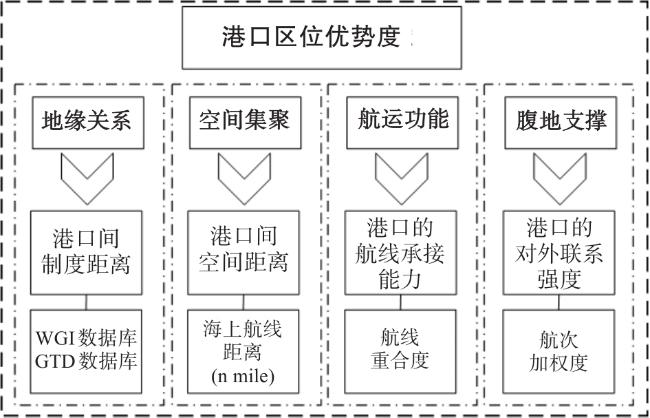
表1 港口区位优势度测算指标与数据来源Table 1 Indicators of port location advantages and data sources |
| 属性构成 | 表达含义 | 测算指标 | 数值范围 | 数据说明 | 数据来源 | 数据类型 |
|---|---|---|---|---|---|---|
| 航运联系 | 航线承接 能力F | 航线重合度 | 0~1 | 两港口航线联系 紧密程度 | 基于《中国航务周刊》 船期数据测算订阅 | 2008、2018年截面数据 |
| 空间集聚 水平 | 空间距离D | 海运航线距离 | 5~12 696 | 海里(n mile) | Marine Circle数据库 (http://www.portdistance.com) | 截面数据、 无时间变化 |
| 地缘关系 | 制度距离Z | 话语权和问责 | 0~100 | 所有国家的 百分位排名 | 世界银行The Worldwide Governance Indicators数据库 (http://info.worldbank.org/governance/wgi/) | 2008、 2018年 截面数据 |
| 政治稳定 | ||||||
| 政府效率 | ||||||
| 监管质量 | ||||||
| 法治程度 | ||||||
| 腐败控制 | ||||||
| 恐怖主义 | 0~1 364 | 恐怖主义活动 发生次数/次 | Global Terrorism Database数据库 (https://www.start.umd.edu/gtd/) | 2008、2018年 截面数据 | ||
| 腹地支撑 | 港口对外联系强度L | 航次加权度 | 3~12 417 | 开通航线频次/次 | 《中国航务周刊》 | 2008、2018年截面数据 |
表2 “海上丝路”沿线港口构成Table 2 List of ports along the Marime Silk Road |
| 大洲 | 港口 |
|---|---|
| 非洲 | 阿比让、阿尔及尔*、班珠尔*、博马*、达喀尔*、达累斯萨拉姆**、丹吉尔**、德班、杜阿拉*、弗里敦*、黑角*、吉布提*、卡宾达*、开普敦、 科纳克里*、科托努、拉各斯、利伯维尔* |
| 罗安达、洛比托*、洛美、马普托*、马塔迪*、毛里求斯、蒙巴萨**、蒙罗维亚*、纳米贝*、努瓦克肖特*、苏丹港*、索约*、特马、瓦赫兰*、 沃尔维斯湾**、伊丽莎白港 | |
| 欧洲 | 阿尔赫西拉斯、阿姆斯特丹*、安特卫普、敖德萨、奥尔胡斯*、巴塞罗那、比雷埃夫斯、不来梅、的里亚斯特**、东方港*、敦刻尔克**、 费利克斯托、符拉迪沃斯托克* |
| 福斯、格但斯克**、汉堡、焦亚陶罗、康斯坦察、科佩尔、克莱佩达*、勒阿弗尔、里加*、里窝那*、里耶卡、鹿特丹、伦敦、马尔萨什洛克、 马耳他*、马拉加*、那不勒斯 | |
| 哥德堡、南安普顿、热那亚、塞萨洛尼基*、圣彼得堡*、塔兰托*、瓦伦西亚、威廉哈芬**、威尼斯**、锡尼什**、新罗西斯克**、伊利伊雷夫 斯基*、泽布吕赫 | |
| 亚洲 | 阿巴斯、阿布扎比、阿利亚加**、阿什杜德、八打雁**、八代*、巴生、巴士拉**、贝鲁特巴林**、槟城**、博多、常州**、达曼、达米埃塔*、 达沃**、大阪、大分、大连、大山**、丹戎帕拉帕斯、德岛* |
| 德山、迪拜、东莞**、东京、杜蒂戈林*、多哈**、防城、福山阿卜杜拉国王港**、福州、釜山、富山、高松、高雄、关丹*、光阳、广岛、广州、 哈兹拉**、海法、海防、豪尔法坎、荷台达*、横滨、胡志明 | |
| 基隆、吉达、加尔各答*、界泉北、今治*、金泽、锦州**、境港、酒田**、卡加延**、卡拉奇、科伦坡、科钦、拉塔基亚*、岘港、连云港、林查班、马尼拉、曼谷、梅尔辛**、门司、蒙德拉、台北** |
|
表3 “海上丝路”沿线港口区位优势度与复杂网络指标相关性检验Table 3 Correlation test of location advantage and complex index of ports along Maritime Silk Road |
| 指标 | 年份 | 区位优势度 | 航次加权度 | 度中心性 | 邻近中心性 | 介中心性 | |||||||||
|---|---|---|---|---|---|---|---|---|---|---|---|---|---|---|---|
| 2008 | 2018 | 2008 | 2018 | 2008 | 2018 | 2008 | 2018 | 2008 | 2018 | ||||||
| 区位优势度 | 2008 | 1.000 | |||||||||||||
| 2018 | 1.000 | ||||||||||||||
| 航次加权度 | 2008 | 0.465** | 1.000 | ||||||||||||
| 2018 | 0.415** | 1.000 | |||||||||||||
| 度中心性 | 2008 | 0.507** | 0.922** | 1.000 | |||||||||||
| 2018 | 0.422** | 0.880** | 1.000 | ||||||||||||
| 邻近中心性 | 2008 | 0.461** | 0.891** | 0.935** | 1.000 | ||||||||||
| 2018 | 0.416** | 0.843** | 0.962** | 1.000 | |||||||||||
| 介中心性 | 2008 | 0.343** | 0.747** | 0.820** | 0.807** | 1.000 | |||||||||
| 2018 | 0.245** | 0.722** | 0.822** | 0.779** | 1.000 | ||||||||||
|
图5 “海上丝路”沿线复杂网络指标等级空间分布Fig.5 Spatial distribution of complex network index of ports along Maritime Silk Road |
| 年份 | 港口航次加权度 | 港口节点中心性 |
|---|---|---|
| 2008 | 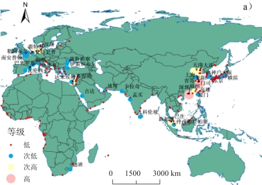 | 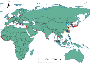 |
| 2018 | 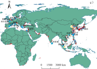 | 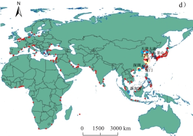 |

1 https://www.start.umd.edu/gtd/
郭建科:参与选题与制定研究框架,负责文章修改,并资助文章的发表;
冯天琪:完成数据收集整理、指标构建计算、内容写作与图表制作;
秦娅风:参与数据收集、文章排版;
刘晓扬:参与摘要修改与图片修改。
|
Barabasi A L, and Albert R. 1999. Emergence of Scaling in Random Net-Works. Science, 286: 509-512.
|
|
曹有挥,曹卫东,金世胜,李海建,王黎明. 2003. 中国沿海集装箱港口体系的形成演化机理. 地理学报,58(3):424-432.
Cao Youhui, Cao Weidong, Jin Shisheng, Li Haijian, and Wang Liming. 2003. The Evolution Mechanism of the Coastal Container Port System of China. Acta Geographica Sinica, 58(3): 424-432.
|
|
陈宏兵,王娜,2008. 中国各港至世界各地船期. 中国航务周刊,(22):183-200.
Chen Hongbing, and Wang Na. 2008. Sailing Schedules at Chinese Ports. China Shipping Gazette, (22): 183-200.
|
|
陈宏兵,王娜,2018. 中国各港至世界各地船期. 中国航务周刊,(23):165-194.
Chen Hongbing, and Wang Na. 2018. Sailing Schedules at Chinese Ports. China Shipping Gazette, (23): 165-194.
|
|
Ducruet C, Lee S W, and Ng A K Y. 2010. Centrality and Vulnerability in Liner Shipping Networks: Revisiting the Northeast Asian Port Hierarchy. Maritime Policy & Management, 37(1): 17-36.
|
|
邓贵仕,武佩剑,田炜. 2008. 全球航运网络鲁棒性和脆弱性研究. 大连理工大学学报,(5):765-768.
Deng Guishi, Wu Peijan, and Tian Wei. 2008. Research on Robustness and Vulnerability of Global Shipping Network. Journal of Dalian University of Technology, (5): 765-768.
|
|
邸玉娜,由林青. 2018. 中国对一带一路国家的投资动因、距离因素与区位选择. 中国软科学,(2):168-176.
Di Yuna, and You Linqing. 2018. Investment Motives, Distances Factors and Location Choice of China's Investment along the Belt and Road. China Soft Science, (2): 168-176.
|
|
董超. 2012. “流空间”的地理学属性及其区域发展效应分析. 地域研究与开发,31(2):5-8,14.
Dong Chao. 2012. On the Geographical Attributes of Space of Flows and Their Effects in Regional Development. Areal Research and Development, 31(2): 5-8, 14.
|
|
董洁霜,范炳全. 2003. 现代港口发展的区位势理论基础. 世界地理研究,12(2):47-53.
Dong Jieshuang, and Fan Bingquan. 2003. The Theoretical Foundation of the Concept of Locational Potential for Modern Ports' Development. World Regional Studies, 12(2): 47-53.
|
|
杜超,王姣娥,莫辉辉. 2016. 中国集装箱航运网络空间格局及复杂性研究. 长江流域资源与环境,25(2):190-198.
Du Chao, Wang Jiao'e, and Mo Huihui. 2016. Spatial Pattern Analysis of China Container Shipping Network on Complex Theory. Resources and Environment in the Yangtze Basin, 25(2): 190-198.
|
|
顾朝林. 2012. 人文地理学导论. 北京:科学出版社.
Gu Chaolin. 2012. Introduction to Human Geography. Beijing: Science Press.
|
|
国家发展改革委、外交部、商务部. 2015. 推动共建丝绸之路经济带和21世纪海上丝绸之路的愿景与行动. (2015-03-31)[2023-08-08]. http://www.mofcom.gov.cn/article/xwfb/xwrcxw/201503/20150300928878.shtml. [National Development and Reform Commission, Ministry of Foreign Affairs, and Ministry of Commerce of the People's Republic of China. 2015. Vision and Actions on Jointly Building Belt and Road. (2015-03-31) [2023-08-08]. http://www.mofcom.gov.cn/article/xwfb/xwrcxw/201503/20150300928878.shtml..]
|
|
高鑫,修春亮,魏冶. 2012. 城市地理学的“流空间”视角及其中国化研究. 人文地理,27(4):32-36,160.
Gao Xin, Xiu Chunliang, and Wei Ye. 2012. Study on the Sinicization of "Space of Flows" Basing on the Visual Angle of Urban Geography. Human Geography, 27(4): 32-36, 160.
|
|
Hoyle B S, and Hilling D. 1984. Seaport Systems and Spaial Change: Technology, Industry and Developmen Strategies. Wiley: Chichesterm.
|
|
蒋冠宏. 2015. 制度差异、文化距离与中国企业对外直接投资风险. 世界经济研究,(8):37-47,127-128. DOI: 10.13516/j.cnki.wes.2015.08.005.
Jiang Guanhong. 2015. Different Institution, Distance of Culture and Risk of Investing Abroad. World Economy Studies, (8): 37-47, 127-128. DOI: 10.13516/j.cnki.wes.2015.08.005.
|
|
金凤君,王成金,李秀伟. 2008. 中国区域交通优势的甄别方法及应用分析. 地理学报,63(8):787-798.
Jin Fengjun, Wang Chengjin, and Li Xiuwei. 2008. Discrimination Method and Its Application Analysis of Regional Transport Superiority. Acta Geographica Sinica, 63(8): 787-798.
|
|
Kogut B, and Singh H. 1988. The Effect of National Culture on the Choice of Entry Mode. Journal of International Business Studies, 19(3): 411-432.
|
|
李小建,苗长虹. 2004. 西方经济地理学新进展及其启示. 地理学报,59(S1):153-161.
Li Xiaojian, and Miao Changhong. 2004. Recent Developments in Western Economic Geographies and Theoretical Thinking for China's Counterpart. Acta Geographica Sinica, 59(S1): 153-161.
|
|
梁双波,曹有挥,吴威,曹卫东,苑惠丽,李传武. 2007. 全球化背景下的南京港城关联发展效应分析. 地理研究,26(3):599-608.
Liang Shuangbo, Cao Youhui, Wu Wei, Cao Weidong, Fan Huili, and Li Chuanwu. 2007. The Effect Analysis of Nanjing City- Port Interactive Development Under the Background of Globalization. Geographical Research, 26(3): 599-608.
|
|
梁双波,曹有挥,曹卫东,何调霞. 2009. 港城关联发展的生命周期模式研究——以南京港城关联发展为例. 人文地理,24(5):66-70.
Liang Shuangbo, Cao Youhui, Cao Weidong, and He Tiaoxia. 2009. A Study on the Life-Circle Pattern of City- Port Interactive Development: Taking Nanjing City-Port Interactive Development as an Example. Human Geograph, 24(5): 66-70.
|
|
莫辉辉,王姣娥,金凤君. 2008. 交通运输网络的复杂性研究. 地理科学进展,27(6):112-120.
Mo Huihui, Wang Jiao'e, and Jin Fengjun. 2008. Complexity Perspectives on Transportation Network. Progress in Geography, 27(6): 112-120.
|
|
牟向伟,陈燕,杨明,李桃迎. 2009. 班轮航运网络拓扑特性. 大连海事大学学报,35(2):34-37.
Mou Xiangwei, Chen Yan, Yang Ming, and Li Taoying. 2009. Topological Features of Liner Shipping Network. Journal of Dalian Maritime University, 35(2): 34-37.
|
|
Newman M E J. 2003. The Structure and Function of Complex Networks. SIAM Review, 45(2): 167-256.
|
|
潘镇. 2006. 制度质量、制度距离与双边贸易. 中国工业经济,(7):45-52. DOI:10.19581/j.cnki.ciejournal.2006.07.006.
Pan Zhen. 2006. Institutional Quality, Institutional Distance and Bilateral Trade. China Industrial Economy,(7): 45-52. DOI:10.19581/j.cnki.ciejournal.2006.07.006.
|
|
潘镇,金中坤. 2015. 双边政治关系、东道国制度风险与中国对外直接投资. 财贸经济(6):85-97. DOI:10.19795/j.cnki.cn11-1166/f.2015.06.008. [Pan Zhen, and Jin Zhongkun. 2015. Bilateral Political Relationship, Host Country Institutional Risk and China's Outward FDI. Finance & Trade Economics,(6): 85-97. ]
|
|
Peng Peng, Cheng Shifen, Chen Jinhai, Liao Mengdi, Wu Lin, Liu Xiliang, and Lu Feng. 2018. A Fine-Grained Perspective on the Robustness of Global Cargo Ship Transportation Networks. Journal of Geographical Sciences, 28(7): 881-899. ]
|
|
秦大河,张国友,宋长青,金凤君,薛德升,杜德斌,陆玉麒,苗长虹,葛岳静,吴志峰,刘建忠,张振克,刘云刚,宁越敏,效存德,王荣成,陈俊华,李娟,胡志丁. 2020. 今天的中国为什么比任何时候都需要世界地理学. 世界地理研究,29(1):1-7.
Qin Dahe, Zhang Guoyou, Song Changqing, Jin Fengjun, Xue Desheng, Du Debin, Lu Yuqi, Miao Changhong, Ge Yuejing, Wu Zhifeng, Liu Jianzhong, Zhang Zhenke, Liu Yungang, Ning Yuemin, Xiao Cunde, Wang Rongcheng, Chen Junhua, Li Juan, and Hu Zhiding. 2020. Why Does China Today Need World Geography More Than Ever. World Regional Studies, 29(1): 1-7.
|
|
Rodrigue J P, and Notteboom T. 2010. Foreland-Based Regionalization: Integrating Intermediate Hubs with Port Hinterlands. Research in Transportation Economics, 27: 19-29.
|
|
孙中伟,路紫. 2005. 流空间基本性质的地理学透视. 地理与地理信息科学,(1):109-112.
Sun Zhongwei, and Lu Zi. 2005. A Geography Perspective to the Elementary Nature of Space of Flows. Geography and Geo-Information Science,(1): 109-112.
|
|
田炜,邓贵仕,武佩剑,车文娇. 2007. 世界航运网络复杂性分析. 大连理工大学学报,(4):605-609.
Tian Wei, Deng Guishi, Wu Peijian, and Che Wenjiao. 2007. Analysis of Complexity in Global Shipping Network. Journal of Dalian University of Technology, (4): 605-609.
|
|
Wang Liehui, Lau Yui-Yip, Su Han, Zhu Yan, and Kanrak Maneerat. 2022. Dynamics of the Asian Shipping Network in Adjacent Ports: Comparative Case Studies of Shanghai-Ningbo and Hong Kong-Shenzhen. Ocean & Coastal Management, 221: 106127.1- 106127.12.
|
|
Watts D J, and Strogatz S H. 1998. Collective Dynamics of "Small-World" Networks. Nature, 393: 440-442.
|
|
Wu D, Wang N, Yu A Q, and Guan Lei. 2018. Vulnerability and Risk Management in the Maritime Silk Road Container Shipping Network. Acta Geographica Sinica, 73(6): 1133-1148.
|
|
王成金,César Ducruet. 2011. 现代集装箱港口体系演进理论与实证. 地理研究,30(3):397-410.
Wang Chengjin, and César Ducruet. 2011. Theoretical Model of Container Port System and Its Empirical Research in Yangtze River Delta. Geographical Research, 30(3): 397-410.
|
|
王丰龙,司月芳. 2019. “一带一路”倡议背景下亚投行设立对中国海外投资的影响研究. 世界地理研究,28(5):1-10.
Wang Fenglong, and Si Yuefang. 2019. A Research on the Effects of AIIB on Chinese OFDI in the Context of the "B&R" Initiative. World Regional Study, 28(5): 1-10.
|
|
王永钦,杜巨澜,王凯. 2014. 中国对外直接投资区位选择的决定因素:制度、税负和资源禀赋. 经济研究,49(12):126-142.
Wang Yongqin, Du Julan, and Wang Kai. 2014. The Determinants of Location Choices of China's ODI: Institutions, Taxations and Resources. Economic Research Journal, 49(12): 126-142.
|
|
吴群锋,杨汝岱. 2019. 网络与贸易:一个扩展引力模型研究框架. 经济研究,54(2):84-101.
Wu Qunfeng, and Yang Rudai. 2019. Network and Trade: Research on the Extended Gravity Equation. Economic Research Journal, 54(2): 84-101.
|
|
吴小节,马美婷. 2022. 制度距离对海外并购绩效的影响机制——并购经验与政治关联的调节作用. 国际商务研究,43(2):13-24.
Wu Xiaojie, and Ma Meiting. 2022. The Influence Mechanism of Institutional Distance on Cross-Border M&A Performance: The Moderated Role of Cross-border M&A Experience and Political Connection. International Business Research, 43(2): 13-24.
|
|
谢宜泽. 2018. 国际比较指标的统计口径与适用范围——以PPP、WGI、CPI为例. 当代经济科学,40(4):29-38,125.
Xie Yize. 2018. Statistical Caliber and Scope of Application of International Comparative Indicators: Taking PPP, WGI, CPI as Examples. Modern Economic Science, 40(4): 29-38, 125.
|
|
许家云,周绍杰,胡鞍钢. 2017. 制度距离、相邻效应与双边贸易——基于“一带一路”国家空间面板模型的实证分析. 财经研究,43(1):75-85.
Xu Jiayun, Zhou Shaojie, and Hu Angang. 2017. Institutional Distance, Neighboring Effects and Bilateral Trade: An Empirical Analysis Based on Spatial Panel Model of "One Belt and One Road" Countries. Journal of Finance and Economics, 43(1): 75-85.
|
|
杨吾扬,梁进社. 1997. 高级经济地理学. 北京:北京大学出版社.
Yang Wuyang, and Liang Jinshe. 1997. Advanced Economic Geography. Beijing: Peking University Press.
|
|
杨阳,马仁锋,王益澄. 2016. 港口-腹地关系研究前沿领域及其动向. 世界科技研究与发展,38(6):1334-1342.
Yang Yang, Ma Renfeng, and Wang Yicheng. 2016. Frontiers and Trends in the Study of Port Hinterland Relations. World Sci-Tech R & D, 38(6): 1334-1342.
|
|
殷翔宇,祝合良,曲明辉. 2022. 中国沿海港口港城关系发展及对城市经济增长作用. 地理科学,42(6):984-992.
Yin Xiangyu, Zhu Heliang, and Qu Minghui. 2022. The Development of the Relationship between Coastal Ports and Cities in China and Its Impact on Urban Economic Growth. Scientia Geographica Sinica, 42(6): 984-992.
|
|
殷翔宇,宗会明,曲明辉. 2023. 我国沿海港口港城关系协同发展与驱动机制研究. 人文地理,38(1):64-70.
Yin Xiangyu, Zong Huiming, and Qu Minghui. 2023. Synergistic Development and Driving Mechanism of Coastal Port-City Relationship in China, Human Geography, 38(1): 64-70.
|
|
臧雷振. 2012. 治理定量研究:理论演进及反思——以世界治理指数(WGI)为例. 国外社会科学,(4):11-16.
Zang Leizhen. 2012. Quantitative Research on Governance: Theoretical Evolution and Reflection: Taking the World Governance Index (WGI) as an Example. Social Sciences Abroad, (4): 11-16.
|
|
张羽. 2017. 东道国制度环境对中国对外直接投资偏好的影响研究. 上海:上海交通大学.
Zhang Yu. 2017. A Study on the Influence of Host Country's Institutional Evironment China's Preference for OFDI. Shanghai: Shanghai Jiao Tong University.
|
|
章锦河,张捷,李娜,梁琳,刘泽华. 2005. 中国国内旅游流空间场效应分析. 地理研究,24(2):293-303.
Zhang Jinhe, Zhang Jie, Li Na, Liang Lin, and Liu Zehua. 2005. An Analysis on Spatial Field Effect of Domestic Tourist Flows in China. Geographical Research, 24(2): 293-303.
|
|
庄佩君. 2009. 区域化:长江三角洲地区集装箱港口群发展战略. 中国航海,32(3):91-96.
Zhuang Peijun. 2009. Regionalization: Development Strategy of Container Port Group in the Yangtze River Delta Region. Navigation of China, 32(3): 91-96.
|
/
| 〈 |
|
〉 |