
生物天敌暴发导致珊瑚礁退化的高分遥感监测与分析——以南海太平岛为例
|
郑金辉(1996—),女,内蒙古呼和浩特人,硕士研究生,主要从事珊瑚礁遥感研究,(E-mail)huihuizheng922@gmail.com; |
收稿日期: 2023-06-13
修回日期: 2023-09-06
网络出版日期: 2023-10-11
基金资助
自然资源部海洋环境探测技术与应用重点实验室开放基金课题(MESTA-2022-B008)
中国高分辨率对地观测专项项目(41-Y30F07-9001-20/22)
海洋领域融合应用示范项目(RHYJKF02)
High Resolution Remote Sensing Monitoring and Analysis of Coral Reef Degradation Caused by Outbreaks of Biological Natural Enemies: A Case Study of the Taiping Island in the South China Sea
Received date: 2023-06-13
Revised date: 2023-09-06
Online published: 2023-10-11
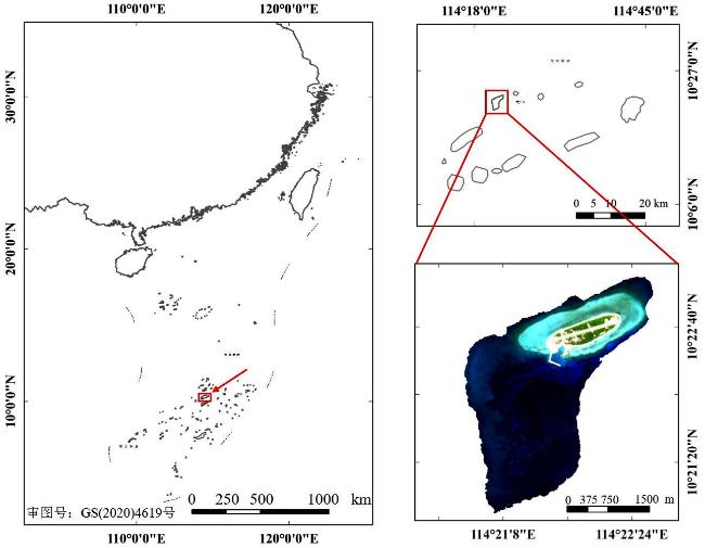
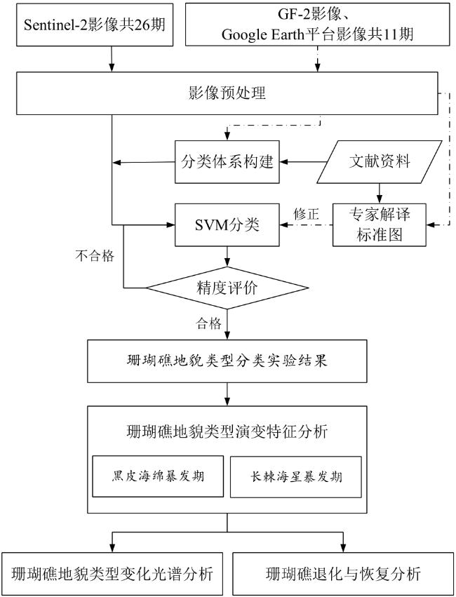
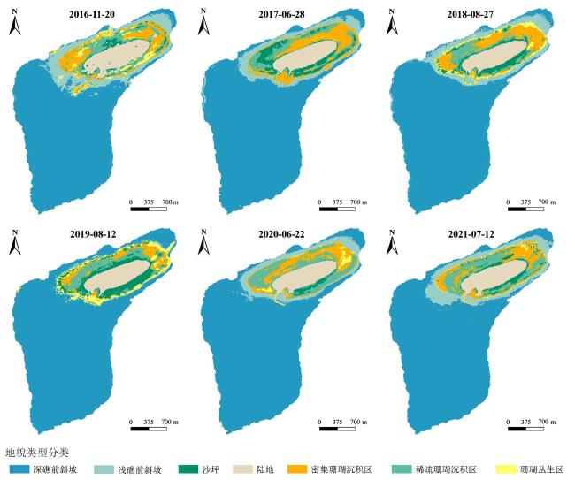
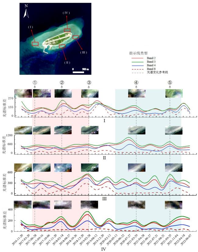
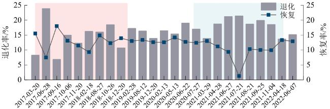
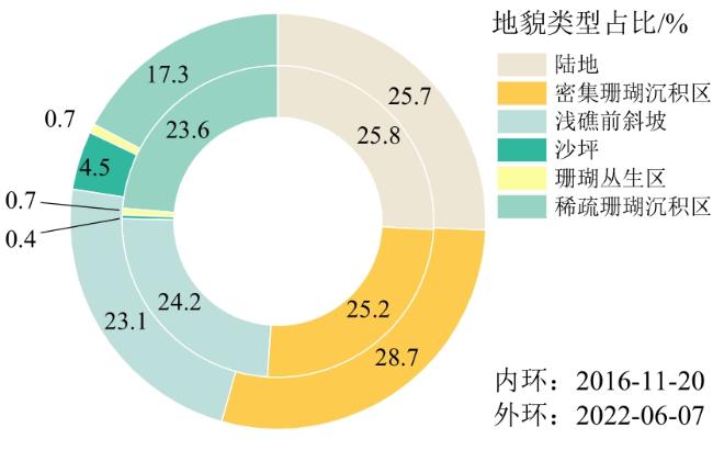
珊瑚生物天敌黑皮海绵、长棘海星在世界范围内暴发严重威胁珊瑚礁生态健康,然而目前珊瑚礁领域尚缺乏生物天敌暴发后对珊瑚礁地貌类型影响的定量研究。文章利用太平岛珊瑚生物天敌黑皮海绵、长棘海星2次暴发事件前后,覆盖太平岛2016—2022年的26期Sentinel-2遥感影像,结合高分辨率GF-2(PMS)遥感影像和卫星遥感影像地理信息系统Google Earth平台中的数据,开展中国南海太平岛珊瑚礁地貌类型遥感影像分类实验,对密集珊瑚沉积区、稀疏珊瑚沉积区、珊瑚丛生区、沙坪、浅礁前斜坡等珊瑚礁地貌类型演变进行特征分析。结果表明:1)结合专家解译知识和支持向量机(Support Vector Machine, SVM)分类算法开展的太平岛珊瑚礁地貌类型分类,最高总体精度和Kappa系数分别为96.46%和0.94。2)在2种珊瑚生物天敌暴发期间,太平岛的珊瑚礁丛生区、密集珊瑚沉积区、稀疏珊瑚沉积区等珊瑚礁地貌类型面积有显著下降;黑皮海绵暴发后对密集珊瑚沉积区影响最大,其面积减少72.92%;长棘海星暴发后对珊瑚丛生区影响最大,其面积减少59.17%。3)2016—2022年,太平岛珊瑚礁退化率高于恢复率,其中2017年3—6月珊瑚礁退化率最高,为23.88%;在2017年6—9月珊瑚礁恢复率最高,为18.03%。

郑金辉 , 任广波 , 胡亚斌 , 张飞飞 , 马毅 , 李明杰 , 王瑞富 . 生物天敌暴发导致珊瑚礁退化的高分遥感监测与分析——以南海太平岛为例[J]. 热带地理, 2023 , 43(10) : 1856 -1873 . DOI: 10.13284/j.cnki.rddl.003762
The global proliferation of natural predators, including Terpios hoshinota sponge and crown-of-thorns starfish, poses a significant threat to the ecological vitality of coral reefs. However, coral reef research currently lacks comprehensive quantitative studies on the ramifications of predator outbreaks in various coral reef landform types. To bridge this knowledge gap, this study utilized a dataset comprising 26 Sentinel-2 remote sensing images spanning the years 2016 to 2022, both pre- and post-two distinct episodes of natural predator outbreaks involving the Terpios hoshinota sponge and crown-of-thorns starfish, within the vicinity of Taiping Island. High-resolution GF-2 (PMS) remote-sensing images and satellite data were used to augment the analysis. Based on data obtained from the Google Earth platform of the Geographic Information System for remote sensing imagery, we conducted an experiment involving the classification of coral reef landform types in Taiping Island in the South China Sea. During the Support Vector Machine (SVM) classification experiments, we performed a meticulous examination of the image interpretation outcomes, making comparisons and rectifications in consultation with domain experts. Classification was performed by analyzing remote sensing images, and the identified landform types included areas characterized by dense coral sedimentation, sparse coral sedimentation, coral clusters, sand flats, and shallow reef front slopes. Subsequent analyses focused on discerning distinctive characteristics and tracing their evolutionary patterns. The findings reveal that (1) this study effectively integrates expert interpretation knowledge and an SVM classification algorithm to classify the various landform types present in Taiping Island's coral reef ecosystem. Remarkably, the classification achieved an unprecedented level of accuracy, with an overall accuracy rate of 96.46% and a kappa coefficient of 0.94. (2) The analysis showed that during the two natural predator outbreaks, the coral reef landforms on Taiping Island, which included dense coral reef areas, dense coral sedimentation areas, and sparse coral sedimentation areas, displayed significant decreases in their respective areas. The outbreak of Terpios hoshinota sponge had the most profound impact on the dense coral sedimentation area, resulting in a 72.92% decrease in the total area. Meanwhile, the outbreak of crown-of-thorns starfish had the most significant effect on the coral cluster area, causing a 59.17% reduction in total area. (3) Over the period spanning from 2016 to 2022, the degradation rate of the coral reefs on Taiping Island exceeded the recovery rate. Notably, the highest degradation rate (23.88%) occurred between March-June 2017. Conversely, the highest rate of recovery (18.03%) was observed from June-September 2017. We analyzed the dynamic characteristics of coral reef landform types, including changes in type distribution, areal extent, degradation rate, and recovery rate. Furthermore, we assessed the influence of natural disturbances on the degradation of coral reef ecosystems, thereby providing valuable insights for conservation and scientific inquiries pertaining to coral reef ecological resources in the waters surrounding Taiping Island. This effort is underpinned by a solid theoretical foundation. The Chinese and English literature cited in this article have contributed significantly to various facets, including coral reef monitoring methodologies, construction of coral reef classification systems, and assessment of coral reef ecosystem health.
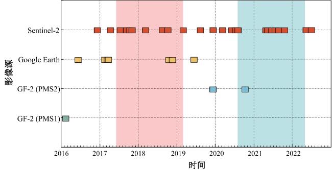
图2 不同遥感影像数量与成像时间统计 Fig.2 Statistics of the number and imaging time of different remote sensing images |
表1 遥感影像信息Table 1 Remote sensing image information |
| 影像源 | 谱段号 | 谱段范围/ nm | 幅宽/ km | 空间分辨 率/m | 影像 数/景 |
|---|---|---|---|---|---|
| Sentinel-2 | 2 | 458~523 | 290 | 10 | 26 |
| 3 | 543~578 | ||||
| 4 | 650~680 | ||||
| 8 | 785~900 | ||||
| GF-2(PMS) | 2 | 450~520 | 45 | 4 | 3 |
| 3 | 520~590 | ||||
| 4 | 630~690 | ||||
| 5 | 770~890 | ||||
| Google Earth | 3 | — | — | 1 | 8 |
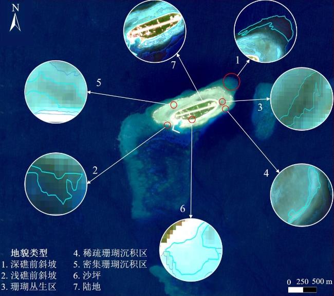
表2 太平岛珊瑚礁地貌类型分类解译标志Table 2 Classification and interpretation signs of coral reef geomorphology types of the Taiping Island |
| 序号 | 研究区地貌类型 | 定义 | 所含底质 | 解译标志(Sentinel-2影像) | 解译特征 |
|---|---|---|---|---|---|
| 1 | 深礁前斜坡 | 岛礁最外缘,坡度0~40°入海,洋流冲刷作用强,极少珊瑚生长,沉积物堆积质较多 | 生物碎屑、砂石 |  | 位于岛礁外侧。深水呈现深蓝色、浅水呈绿色,由于含有暗礁,故有网状纹理特征 |
| 2 | 浅礁前斜坡 | 深礁前斜坡内,坡度>40°,坡面伴有沟槽,有珊瑚分布及沉积物 | 礁块、珊瑚碎屑、 活珊瑚 |  | 位于深礁前斜坡内侧,整体呈深蓝绿色,对岛礁呈现包围状 |
| 3 | 珊瑚丛生区 | 密集珊瑚沉积区内部,以珊瑚礁及活珊瑚为主 | 礁块、生物碎屑、 活珊瑚 |  | 片状分布,整体呈暗绿色,纹理有明显分界 |
| 4 | 稀疏珊瑚 沉积区 | 位于浅礁前斜坡内部,位置较分散,珊瑚礁块沉积较少 | 珊瑚砂、活珊瑚 |  | 面状分布,整体呈较亮的蓝绿色,有棕黑色点状分布 |
| 5 | 密集珊瑚 沉积区 | 围绕珊瑚丛生区形成,坡度较缓,其底部沉积有较多珊瑚断枝 | 珊瑚砂、活珊瑚、 珊瑚碎屑 |  | 面状分布,整体呈现灰绿色,有模糊黑色纹状 |
| 6 | 沙坪 | 浅海处砂质,低潮时出露海面,随海流堆积而成,位置多变 | 陆源碎屑、生物碎屑、 砂石、珊瑚砂 |  | 块状分布,整体呈现极亮的淡蓝色,无明显纹理特征 |
| 7 | 陆地 | 海岸线内,出露于海面之上,表面附有土壤,生长有陆生植物 | 土壤、植被、砂石 |  | 位于岛礁中央,包含较纯净的绿色和白色 |
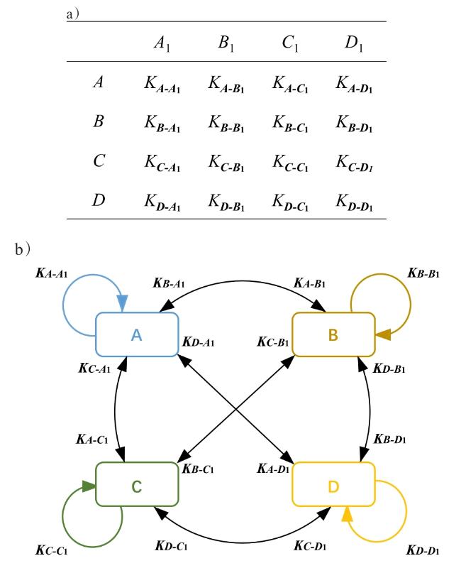
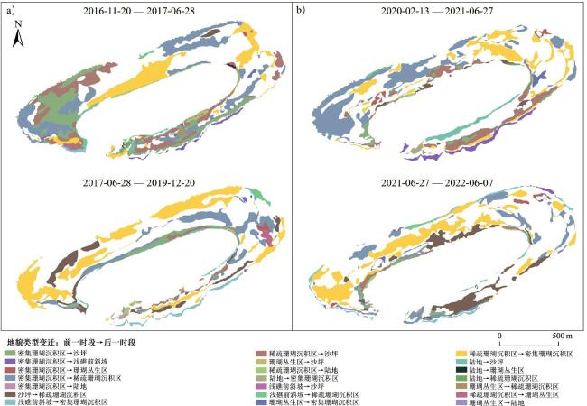
图5 转移矩阵原理(a. 珊瑚礁地貌类型转移矩阵;b. 珊瑚礁地貌类型转移量示意) Fig.5 Schematic diagram of transfer matrix principle (a. Coral reef landform type transfer matrix; b. Schematic diagram of coral reef landform type transfer) |
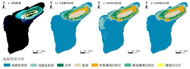
图6 太平岛珊瑚礁地貌类型分类过程(以2017-06-28所选影像为例)Fig.6 Classification process of coral reef landform types in Taiping Island (taking the image selected on June 28th, 2017 as an example) |
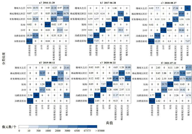
表3 太平岛珊瑚礁地貌类型精度评定(专家解译修正后)Table 3 Precision evaluation table for the landform types of the Taiping Island coral reef (after expert interpretation and correction) |
| 时间 | OA/% | Kappa系数 |
|---|---|---|
| 均值 | 95.30 | 0.89 |
| 2016-11-20 | 92.29 | 0.87 |
| 2017-06-28 | 95.70 | 0.93 |
| 2018-08-27 | 96.46 | 0.94 |
| 2019-08-12 | 94.87 | 0.91 |
| 2020-06-22 | 96.45 | 0.86 |
| 2021-07-12 | 96.02 | 0.85 |
表4 2016-11-20—2017-06-28太平岛珊瑚礁地貌类型变迁转移矩阵Table 4 Transition matrix of changes in coral reef geomorphic types on the Taiping Island during November 20th, 2016 to June 28th, 2017 |
| 面积转化量 | 2017-06-28地貌类型 | 总计 | |||||
|---|---|---|---|---|---|---|---|
| 2016-11-20 地貌类型 | 陆地 | 密集珊瑚 沉积区 | 浅礁前斜坡 | 沙坪 | 珊瑚丛生区 | 稀疏珊瑚 沉积区 | |
| 总计 | 51.43 | 34.16 | 49.73 | 28.22 | 0.51 | 42.13 | 206.19 |
| 陆地 | 50.46 | 0.52 | 0 | 1.55 | 0.16 | 0.39 | 53.08 |
| 密集珊瑚 沉积区 | 0 | 19.16 | 1.02 | 12.66 | 0.25 | 19.01 | 52.10 |
| 浅礁前斜坡 | 0 | 0.59 | 48.71 | 0.25 | 0 | 0.38 | 49.93 |
| 沙坪 | 0 | 0 | 0 | 0.28 | 0 | 0.54 | 0.82 |
| 珊瑚丛生区 | 0.03 | 0.43 | 0 | 0.51 | 0 | 0.46 | 1.43 |
| 稀疏珊瑚 沉积区 | 0.94 | 13.46 | 0 | 12.97 | 0.11 | 21.35 | 48.83 |
表5 2017-06-28—2019-12-20太平岛珊瑚礁地貌类型变迁转移矩阵Table 5 Transition matrix of changes in coral reef geomorphic types on the Taiping Island during June 28th, 2017 to December 20th, 2019 |
| 面积转化量 | 2019-12-20地貌类型 | 总计 | |||||
|---|---|---|---|---|---|---|---|
| 2017-06-28 地貌类型 | 陆地 | 密集珊瑚 沉积区 | 浅礁前斜坡 | 沙坪 | 珊瑚 丛生区 | 稀疏珊瑚 沉积区 | |
| 总计 | 52.11 | 59.74 | 48.19 | 10.51 | 1.30 | 34.43 | 206.28 |
| 陆地 | 50.17 | 0.04 | 0 | 1.07 | 0 | 0.25 | 51.52 |
| 密集珊瑚 沉积区 | 0.26 | 19.77 | 0.08 | 3.00 | 0.49 | 10.56 | 34.16 |
| 浅礁前斜坡 | 0 | 1.84 | 47.18 | 0 | 0 | 0.71 | 49.73 |
| 沙坪 | 1.03 | 16.12 | 0.45 | 4.17 | 0.02 | 6.42 | 28.22 |
| 珊瑚丛生区 | 0.11 | 0.17 | 0 | 0.15 | 0 | 0.09 | 0.51 |
| 稀疏珊瑚 沉积区 | 0.55 | 21.80 | 0.47 | 2.13 | 0.79 | 16.40 | 42.13 |
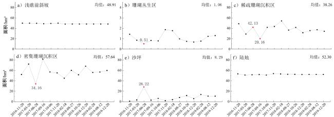
表6 黑皮海绵暴发研究时段太平岛珊瑚礁地貌类型增减统计 (hm2)Table 6 Changes in coral reef geomorphic types on the Taiping Island during the period of Terpios hoshinota sponge outbreak study |
| 时间 | 陆地 | 密集珊瑚沉积区 | 浅礁前斜坡 | 沙坪 | 珊瑚 丛生区 | 稀疏珊瑚沉积区 |
|---|---|---|---|---|---|---|
| 2016-11-20 | 53.35 | 52.10 | 49.93 | 0.82 | 1.43 | 48.83 |
| 2017-03-20 | -2.29 | 20.05 | -0.02 | 2.57 | -0.57 | -19.78 |
| 2017-06-28 | 0.59 | -37.99 | -0.18 | 24.83 | -0.34 | 13.09 |
| 2017-09-16 | 0.43 | 47.34 | -0.90 | -25.23 | 0.32 | -21.97 |
| 2017-10-06 | -1.05 | -24.55 | 0.53 | 3.23 | -0.04 | 21.72 |
| 2017-11-20 | 2.72 | -1.78 | 0.61 | -4.17 | 1.08 | 1.72 |
| 2018-02-18 | -0.56 | -10.16 | -1.79 | 1.89 | -0.10 | 10.72 |
| 2018-08-27 | -0.62 | 14.97 | 0.13 | 4.10 | -0.79 | -17.66 |
| 2018-10-26 | -0.09 | -8.33 | 0 | 3.63 | -0.24 | 5.04 |
| 2018-12-20 | -0.33 | 16.38 | 0 | -5.92 | -0.06 | -10.06 |
| 2019-02-28 | 0.06 | -12.03 | 0 | 7.88 | 0.09 | 4.00 |
| 2019-08-12 | 0 | 0.86 | 0 | -3.06 | 0.46 | 1.74 |
| 2019-12-20 | 0 | 2.91 | 0 | -0.04 | 0.07 | -2.94 |
|
表7 2020-02-13—2021-06-27太平岛珊瑚礁地貌类型变迁转移矩阵Table 7 Transition matrix of changes in coral reef geomorphic types on the Taiping Island during February 13th, 2020 to June 27th, 2021 |
| 面积转化量 | 2021-06-27地貌类型 | 总计 | |||||
|---|---|---|---|---|---|---|---|
| 2020-02-13地貌类型 | 陆地 | 密集珊瑚沉积区 | 浅礁前斜坡 | 沙坪 | 珊瑚丛生区 | 稀疏珊瑚沉积区 | |
| 总计 | 50.28 | 43.88 | 48.99 | 23.24 | 1.11 | 36.52 | 204.02 |
| 陆地 | 48.75 | 0.51 | 0 | 2.38 | 0 | 0.20 | 51.85 |
| 密集珊瑚沉积区 | 0.06 | 29.81 | 2.92 | 2.53 | 0.76 | 20.42 | 56.5 |
| 浅礁前斜坡 | 0 | 0 | 45.92 | 0 | 0 | 0.32 | 46.24 |
| 沙坪 | 1.15 | 0.65 | 0 | 10.52 | 0 | 1.30 | 13.63 |
| 珊瑚丛生区 | 0 | 0.80 | 0 | 0.02 | 0.34 | 0.03 | 1.20 |
| 稀疏珊瑚沉积区 | 0.31 | 12.11 | 0.15 | 7.78 | 0 | 14.25 | 34.6 |
表8 2021-06-27—2022-06-07太平岛珊瑚礁地貌类型变迁转移矩阵Table 8 Transition matrix of changes in coral reef geomorphic types on the Taiping Island during June 27th, 2021 to June 7th, 2022 |
| 面积转化量 | 2022-06-07地貌类型 | 总计 | |||||
|---|---|---|---|---|---|---|---|
| 2021-06-27地貌类型 | 陆地 | 密集珊瑚沉积区 | 浅礁前斜坡 | 沙坪 | 珊瑚丛生区 | 稀疏珊瑚沉积区 | |
| 总计 | 52.30 | 58.70 | 47.32 | 9.29 | 1.47 | 35.34 | 204.42 |
| 陆地 | 49.98 | 0.06 | 0 | 0.46 | 0 | 0.15 | 50.65 |
| 密集珊瑚沉积区 | 0.15 | 31.40 | 0.54 | 1.29 | 0.74 | 9.76 | 43.88 |
| 浅礁前斜坡 | 0 | 2.19 | 46.38 | 0 | 0 | 0.45 | 49.02 |
| 沙坪 | 1.73 | 6.43 | 0.05 | 6.16 | 0 | 8.86 | 23.24 |
| 珊瑚丛生区 | 0 | 0.38 | 0 | 0 | 0.72 | 0 | 1.11 |
| 稀疏珊瑚沉积区 | 0.44 | 18.23 | 0.36 | 1.38 | 0 | 16.12 | 36.52 |
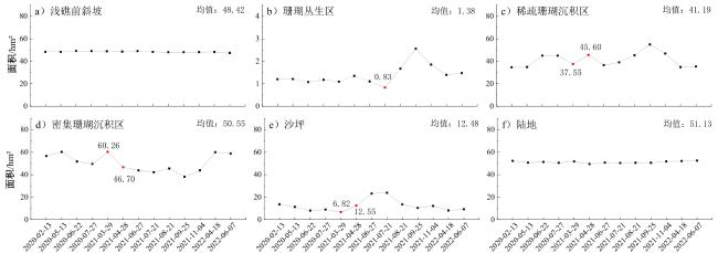
表9 长棘海星暴发研究时段太平岛各珊瑚礁地貌类型增减统计 (hm2)Table 9 Changes in each coral reef geomorphic type on the Taiping Island during the period of crown-of-thorns starfish outbreak study |
| 时间 | 陆地 | 密集珊瑚沉积区 | 浅礁前斜坡 | 沙坪 | 珊瑚丛生区 | 稀疏珊瑚沉积区 |
|---|---|---|---|---|---|---|
| 2020-02-13 | 52.20 | 56.58 | 48.32 | 13.63 | 1.20 | 34.60 |
| 2020-05-13 | -1.55 | 3.60 | 0 | -2.29 | 0.01 | 0.23 |
| 2020-06-22 | 0.71 | -8.47 | 0.79 | -3.21 | -0.13 | 10.16 |
| 2020-07-27 | -0.85 | -2.14 | -0.08 | 0.89 | 0.10 | -0.01 |
| 2021-03-29 | 1.27 | 10.68 | -0.19 | -2.19 | -0.08 | -7.43 |
| 2021-04-28 | -2.25 | -13.56 | -0.26 | 5.72 | 0.25 | 8.05 |
| 2021-06-27 | 1.15 | -2.82 | 0.46 | 10.69 | -0.24 | -9.07 |
| 2021-07-21 | -0.31 | -1.66 | -0.69 | 0.67 | -0.27 | 2.53 |
| 2021-08-21 | 0.19 | 3.26 | -0.24 | -10.37 | 0.84 | 6.26 |
| 2021-09-25 | -0.02 | -7.41 | 0 | -3.10 | 0.89 | 9.64 |
| 2021-11-04 | 1.23 | 5.76 | 0.05 | 1.73 | -0.71 | -8.08 |
| 2022-04-18 | 0.35 | 16.09 | 0.13 | -3.94 | -0.46 | -12.08 |
| 2022-06-07 | 0.42 | -1.19 | -0.93 | 1.06 | 0.08 | 0.55 |
|

1 活珊瑚覆盖率:指珊瑚生长覆盖的面积占岛礁总体面积的百分比。
2 资料来源:https://www.agriharvest.tw/archives/20987#:~:text=%E5%8D%97%E6%B2%99%E5%A4%AA%E5%B9%B3%E5%B3%B6%E5%91%A8%E9%82%8A%E6%B5%B7,UCN%E6%98%93%E5%8D%B1%E7%89%A9%E7%A8%AE
3 https://scihub.copernicus.eu/dhus/#/home
4 珊瑚礁覆盖率:指有活珊瑚生长覆盖的地貌类型面积占岛礁总体面积的百分比。
5 不等于实际暴发时间,影像获取时间代表的是这一时间点的状况信息,而具体一段时间的整体情况及变化趋势须通过多时相以及多源数据才能完整掌握。
6 http://typhoon.nmc.cn
郑金辉:进行研究构思和设计、数据收集与分析以及论文撰写工作;
任广波、马毅:参与论文的审阅与修订工作;
胡亚斌:参与实验与论文的指导工作;
张飞飞:参与实验数据收集分析及论文修改工作;
李明杰:参与论文的核实与验证工作;
王瑞富:参与论文的监督与指导工作。
|
Brayn Patrick G. 1973. Growth Rate, Toxicity, and Distribution of the Encrusting Sponge Terpios sp. (Hadromerida: Suberitidae) in Guam, Mariana Islands. Micronesica, (9): 237-242.
|
|
陈启东,邓孺孺,秦雁,熊龙海,何颖清. 2015. 不同生长状态珊瑚光谱特征. 生态学报,35(10):3394-3402.
Chen Qidong, Deng Ruru, Qin Yan, Xiong Longhai, and He Yingqing. 2015. Analysis of Spectral Characteristics of Coral under Different Growth Patterns. Acta Ecologica Sinica, 35(10): 3394-3402.
|
|
程益锋,黄文骞,吴迪,罗兴潮. 2018. 基于高分一号卫星影像的珊瑚岛礁分类方法. 海洋测绘,38(6):49-53.
Cheng Yifeng, Huang Wenqian, Wu Di, and Luo Xingchao. 2018. Research on the Technique of Image Processing of Five Combination of Wide Angle Camera. Hydrographic Surveying and Charting, 38(6): 49-53.
|
|
Chow Savanna Wenhua, Shashank Keshavmurthy, James Davis Reimer, Nicole de Voogd, Huang Hui, Wang Jihterng, Tang Senlin, Peter Schupp J, Tang Chunhong, Liew Hockchark, Keryea Soong, Beginer Subhan, Hawis Madduppa, and Chao lun Allen. 2022. Population Genetics and Demography of the Coral-Killing Cyanobacteriosponge, Terpios Hoshinota, in the Indo-West Pacific. PeerJ., 10: 1-26.
|
|
Diraviya Raj K, Selva Bharath M, Mathews G, Aeby Greta S, and Patterson Edward J. K. 2018. Coral-Killing Sponge Terpios Hoshinota Invades the Corals of Gulf of Mannar, Southeast India. Current Science (Bangalore), 114(5): 1117-1119.
|
|
董娟,任广波,胡亚斌,逄今朝,马毅. 2020. 基于高分辨率遥感的珊瑚礁地貌单元体系构建和分类方法——以8波段Worldview-2影像为例. 热带海洋学报,39(4):116-129.
Dong Juan, Ren Guangbo, Hu Yabin, Pang Jinzhao, and Ma Yi. 2020. Construction and Classification of Coral Reef Geomorphic Unit System Based on High-Resolution Remote Sensing: Using 8-Band Worldview-2 Image as an Example. Journal of Tropical Oceanography, 39(4): 116-129.
|
|
董娟. 2021. 基于高分辨率卫星遥感的西沙群岛活珊瑚覆盖率估算与分析. 青岛:自然资源部第一海洋研究所.
Dong Juan. 2021 Estimation and Analysis of Living Coral Cover in Xisha Islands Based on High Resolution Satellite Remote Sensing. Qingdao: First Institute of Oceanography Ministry of Natural Resources.
|
|
Glenn De'ath, Katharina E Fabricius, Hugh Sweatman, and Marji Puotinen. 2012. The 27-Year Decline of Coral Cover on the Great Barrier Reef and its Causes. Proceedings of the National Academy of Sciences, 109(44): 17995-17999.
|
|
黄荣永,余克服,王英辉,刘嘉鎏,张惠雅. 2019. 珊瑚礁遥感研究进展. 遥感学报,23(6):1091-1112.
Huang Rongyong, Yu Kefu, Wang Yinghui, Liu Jialiu, and Zhang Huiya. 2019. Progress of the Study on Coral Reef Remote Sensing. Journal of Remote Sensing, 23(6): 1091-1112.
|
|
John Hedley D, Chris Roelfsema, Vittorio Brando, Claudia Giardino, Tiit Kutser, Stuart Phinn, Peter J Mumby, Omar Barrilero, Jean Laporte, and Benjamin Koetz. 2018. Coral Reef Applications of Sentinel-2: Coverage, Characteristics, Bathymetry and Benthic Mapping with Comparison to Landsat 8. Remote Sensing of Environment, 216: 598-614.
|
|
Julianna Renzi J, Elizabeth C Shaver, Deron Burkepile E., and Brian Silliman R. 2022. The Role of Predators in Coral Disease Dynamics. Coral Reef, 41(2): 405-422.
|
|
Konstantin Tkachenko S, and Duong Thuy Hoang. 2022. Concurrent Effect of Crown-of-Thorns Starfish Outbreak and Thermal Anomaly of 2020 on Coral Reef Communities of the Spratly Islands (South China Sea). Marine Ecology, 43 (e12717): 1-13.
|
|
Liao Minghui, Tang Senling, Hsu Chiaming, Wen Kouchang, Wu Henry, Chen Wenming, Wang Jihterng, Meng Peijie, Twan Wenhung, Lu Chungkuang, Dai Changfeng, Soong Keryea, and Chen Chaolun Allen. 2007. The Black Disease of Reef-Building Corals at Green Island, Taiwan-Outbreak of a Cyanobacteriosponge, Terpios Hoshinota (Suberitidae; Hadromerida). Zoological Studies, 46(4): 520.
|
|
Liu Wenchien Jennie, Jens Thorvald Høeg, and Chan Benny K K Chan. 2016. How Do Coral Barnacles Start Their Life in Their Hosts?. Biology Letters, 12(6): 1-5.
|
|
Liu Peng, Choo Kim-Kwang Raymond, Wang Lizhe, and Huang Fang. 2017. SVM or Deep Learning? A Comparative Study on Remote Sensing Image Classification. Soft Computing, 21(23): 7053-7065.
|
|
李弘毅,刘永学,张思宇,孙超,孙佳琪. 2018. 地理信息技术支撑下的南海岛礁资源环境研究进展与展望. 地理科学进展,37(11):1454-1462.
Li Hongyi, Liu Yongxue, Zhang Siyu, Sun Chao, and Sun Jiaqi. 2018. Progress and Prospects on Coral Reefs Research in the South China Sea Based on the Application of Geographic Information Technologies. Progress in Geography, 37(11): 1454-1462.
|
|
李元超,梁计林,吴钟解,陈石泉. 2019. 长棘海星的暴发及其防治. 海洋开发与管理,36(8):9-12.
Li Yuanchao, Liang Jilin, Wu Zhongjie, and Chen Shiquan. 2019. Outbreak and Prevention of Acanthaster Planci. Ocean Development and Management, 36(8): 9-12.
|
|
La Ode Muhammad Yasir Haya, Baru Sadarun, Muslim Tadjudah, Analuddin Kangkuso, La Ode Alirman Afu, Asrin Ginong Pratikino, Amadhan Takwir, and Masahiko Fujii. 2022. Assessing Long-term Coral Reef Degradation in Indonesia's Tiworo Strait Marine Conservation Area Using Remote Sensing and Rapid Appraisal for Fisheries Approaches. Modeling Earth Systems and Environment, 8(4): 4731-4748.
|
|
Mohsen Kayal, Julie Vercelloni, Thierry Lison de Loma, Pauline Bosserelle, Yannick Chancerelle Sylvie Geoffroy, Ce´line Stievenart, Francois Michonneau, Lucie Penin, Serge Planes, and Mehdi Adjeroud. 2012. Predator Crown-of-Thorns Starfish (Acanthaster Planci) Outbreak, Mass Mortality of Corals, and Cascading Effects on Reef Fish and Benthic Communities. PLoS One, 7(10): 1-9.
|
|
Masashi Yomogida, Masaru Mizuyama, Toshiki Kubomura, and James Davis Reimer. 2017. Disappearance and Return of an Outbreak of the Coral-Killing Cyanobacteriosponge Terpios hoshinota in Southern Japan. Zool Studies, 56(7): 1-10.
|
|
Nyan Linn Tun, Alexander Gavrilov, Naing Min Tun, Do Minh Trieu, and Htet Aung. 2021. Remote Sensing Data Classification Using a Hybrid Pre-Trained VGG16 CNN-SVM Classifier. IEEE, 9396706: 2171-2175.
|
|
Pratchett M.S, Schenk T.J, Baine M, Syms C, and Baird A H. 2009. Selective Coral Mortality Associated with Outbreaks of Acanthaster planci L. in Bootless Bay, Papua New Guinea. Marine Environmental Research, 67(4/5): 230-236.
|
|
逄今朝,任广波,施祺,朱海天,胡亚斌,董娟,马毅. 2021. 基于底质类型变化监测的2005-2018年西沙永乐群岛珊瑚礁白化分析. 海洋科学,45(6):92-106.
Pang Jinzhao, Ren Guangbo, Shi Qi, Zhua Haitian, Hu Yabin, Dong Juan, and Ma Yi. 2021. Analysis of Coral Reef Bleaching in Yongle Islands of Xisha from 2005 to 2018 Based on Sediment Types Change Monitoring. Marine Sciences, 45(6): 92-106.
|
|
Sarah Hamylton M., Rafael Carvalho C, Stephan Duce, Chris Roelfsema M, and Ana Vila-Conceog. 2016. Linking Pattern to Process in Reef Sediment Dynamics at Lady Musgrave Island, Southern Great Barrier Reef. Sedimentology, 63(6): 1634-1650.
|
|
Siti Aini N, Tang Senlin and Hideyuki Yamashiro. 2021. Monthly Progression Rates of the Coral-killing Sponge Terpios Hoshinota in Sesoko Island, Okinawa, Japan. Coral Reef, 40(3): 973-981.
|
|
Wei Khangheng, Ho Mingjay, Kuo Chaoyang, Huang Yayi, Ko Chiaying, Jeng Mingshiou, and Chen Chaolun Allen. 2022. Crown-of-Thorns Starfish Outbreak at Taiping Island (Itu Aba), Spratlys, South China Sea. Bulletin of Marine Science, 98(1): 101-102.
|
|
夏小明. 2012. 中国海岛(礁)名录. 北京:海洋出版社.
Xia Xiaoming. 2012. List of Islands (Reefs) in China.Beijing: China Ocean Press.
|
|
徐新良,庞治国,于信芳. 2014. 土地利用/覆被变化时空信息分析方法及应用. 北京:科学技术文献出版社.
Xu Xinliang, Pang Zhiguo, and Yu Xinfang. 2014. Land Use/Cover Change Spatiotemporal Information Analysis Method and Application. Beijing: Scientific and Technical Documentation Press.
|
|
Xu Jingping, Zhao Jianhua, Wang Fei, Chen Yanlong, and Lee Zhongping. 2021. Detection of Coral Reef Bleaching Based on Sentinel-2 Multi-Temporal Imagery: Simulation and Case Study. Frontiers in Marine Science, 56(7): 1-15.
|
|
余克服. 2018. 珊瑚礁科学概论. 北京:科学出版社.
Yu Kefu. 2018. Introduction to the Science of Coral Reefs. Beijing: Science Press.
|
|
Yang Sungyin, Chen Hsingju, Ho Mingjay, Chen Yenjia, Huang Yayi, Chow Wenhua Savanna, Tang Senlin, Jeng Mingshiou, and Chen Chaolun Allen. 2018. Outbreak of Coral-Killing Cyanobacteriasponge, Terpios hoshinota, in Taiping Island (Itu Aba), Spratlys, South China Sea. Bulletin of Marine Science, 94(4): 1543-1544.
|
|
Zuo Xiuling, Su Fenzhen, Zhao Huanting, Zhang Junjue, Wang Qi, and Wu Di. 2017. Regional Hard Coral Distribution within Geomorphic and Reef Flat Ecological Zones Determined by Satellite Imagery of the Xisha Islands, South China Sea. Chinese Journal of Oceanology and Limnology, 35(3): 501-514.
|
|
张飞飞,任广波,胡亚斌,马毅. 2023. 融合地理空间认知的珊瑚礁地貌单元高分遥感分类方法. 海洋技术学报,42(1):1-15.
Zhang Feifei, Ren Guangbo, Hu Yabin, and Ma Yi. 2023. A High-Resolution Remote Sensing Classification Method of Coral Reef Geomorphic Units Integrating Geospatial Cognition. Journal of Ocean Technology, 42(1): 1-15.
|
/
| 〈 |
|
〉 |