
基于城市实体地域的城乡接合部空间界定研究——以广州市为例
|
方鹏飞(1994—),男,安徽铜陵人,博士研究生,主要研究方向为城镇化与城市区域经济,(E-mail)fpf199401@126.com; |
收稿日期: 2023-05-15
修回日期: 2023-06-20
网络出版日期: 2024-02-08
基金资助
国家自然科学基金面上项目“移动互联网时代城乡接合部空间重构的特征、机制与规划应对研究”(52378059)
国家自然科学基金面上项目“圈群空隙地区的县域城镇化:空间格局、动力机制与规划应对研究”(52278066)
Spatial Definition of Urban-Rural Fringe Based on the Physical Urban Area: A Case Study of Guangzhou City
Received date: 2023-05-15
Revised date: 2023-06-20
Online published: 2024-02-08
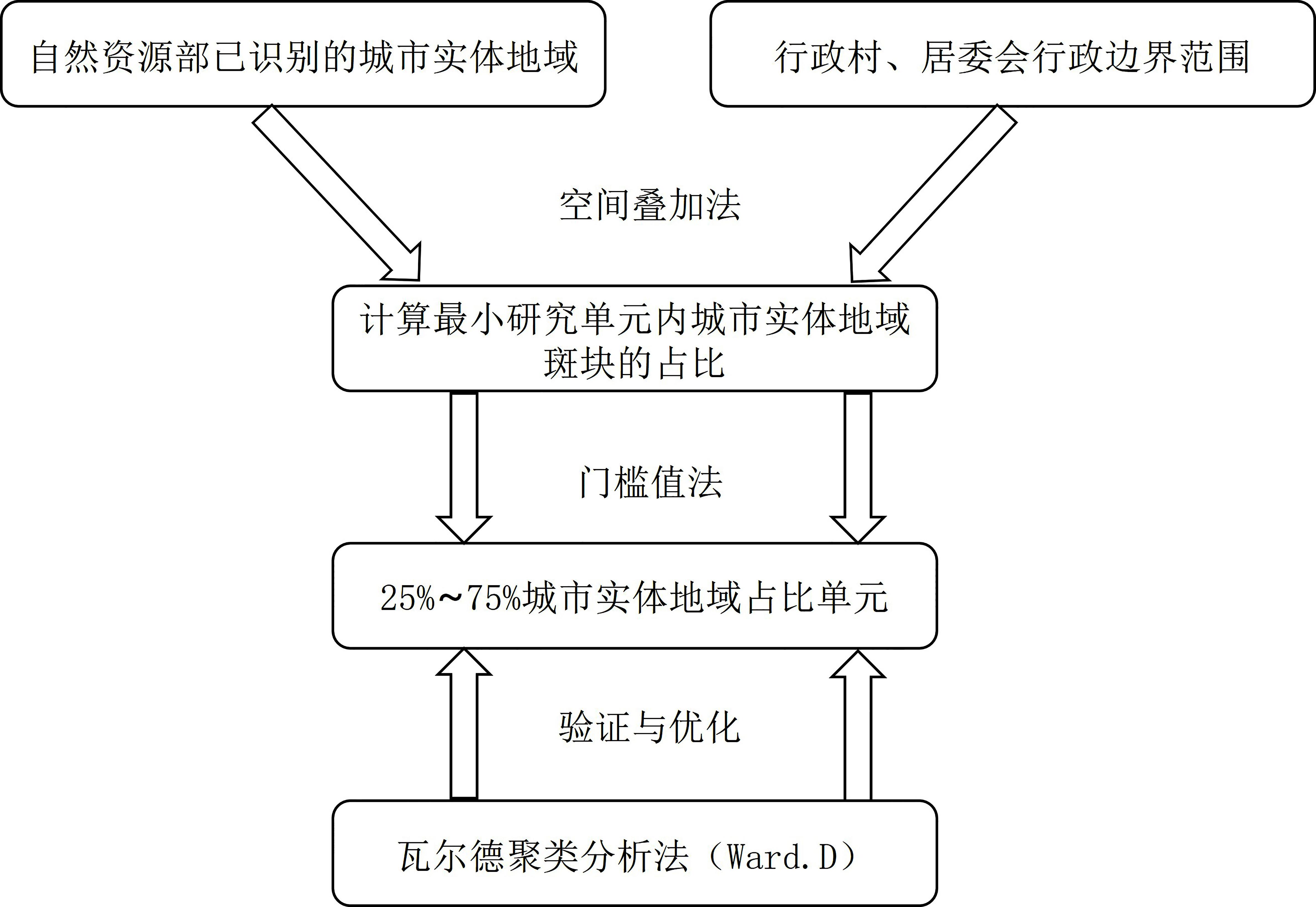
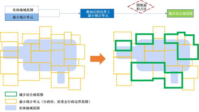
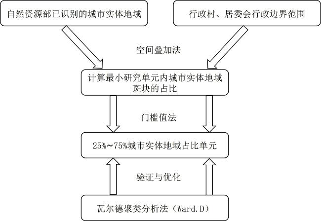
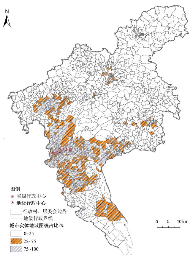
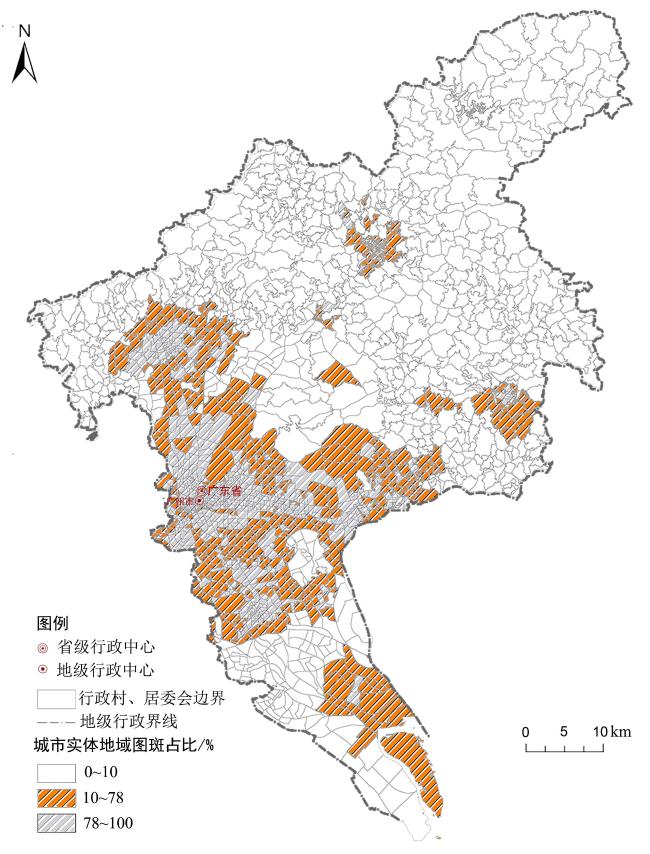
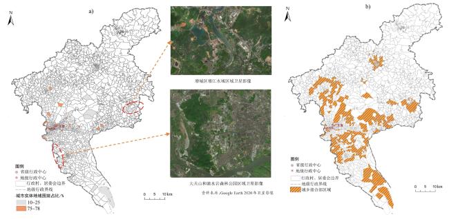
当前国内外城乡接合部空间界定研究尚未达成共识,在行政管理实践中也未形成明确的标准,导致了城乡接合部空间治理的现实困境。基于此,文章提出基于城市实体地域的城乡接合部空间界定方法,对广州市进行实证研究。结果表明:1)以自然资源部高精度遥感和土地调查数据准确识别的城市实体地域范围为城乡接合部空间界定测算指标,以明确的行政村、居委会为最小统计单元,可以有效地衔接国土空间规划技术体系;2)采用国内外大多数研究认同的25%~75%理想值与聚类分析法,并以广州市为典型案例进行城乡接合部空间界定阈值的优化与检验,最终确定广州市城乡接合部空间界定合理阈值为10%~75%;3)精准的测算指标、明确的研究单元和可操作性强的界定方法,可以较好地识别出城乡接合部空间,同时也为更深入的空间研究与治理提供支撑。
方鹏飞 , 罗震东 , 张佶 , 毕瑜菲 . 基于城市实体地域的城乡接合部空间界定研究——以广州市为例[J]. 热带地理, 2024 , 44(2) : 339 -349 . DOI: 10.13284/j.cnki.rddl.003798
The urban-rural fringe is located between the central urban built-up area and the rural hinterland, which is a transition zone for land use, economic development, and population structure. It is the most dynamic area between urban and rural areas and has become the focus of academic research in terms of geography, sociology, and urban planning. Boundary definition is the most fundamental and primary task for urban research and is particularly important for the spatial definition of the urban-rural fringe. However, a literature review reveals that an unclear spatial definition hinders in-depth scientific research on the urban-rural fringe. The absence of a spatial scope also results in a lack of targeted spatial governance policies attuned to the unique characteristics of urban, non-urban, rural, and both urban and rural areas. Existing policy instruments that exclusively focus on urban or rural areas face significant challenges in fringe regions. Recently, the establishment of a national land spatial planning system has created favorable conditions for studying the spatial definition of urban-rural junction areas. The simultaneous implementation of Territorial and Spatial Planning surveys as part of the construction of this planning system also provides technical support for accurately defining these junction areas. High precision "three adjustments" data allows for an accurate representation of the current state of urban and rural land use, enabling the precise identification of the physical geographical extent of cities. In the context of this study, a reasonable and widely accepted method for spatially defining the urban-rural fringe is essential. To address these issues, this study proposes a spatial definition method based on the urban entity regions identified in three land spatial planning surveys. The approach relies on mature territorial planning technology and addresses three key questions: indicators, thresholds, and units for defining the urban-rural fringe. 1) These indicators were derived from the precise identification of physical urban areas by the Ministry of Natural Resources of the People's Republic of China. The research units were administrative villages and neighborhood committees from previous government policies. It can effectively connect with the territorial spatial planning technology system; 2) Adopt the 25% to 75% ideal value and cluster analysis method recognized based on a comprehensive review of relevant literature and practices in spatially defining the urban-rural fringe domestically and internationally. At the end of the paper, Guangzhou is taken as a typical case study to test the effectiveness of the proposed method in defining the spatial boundaries of the urban-rural fringe. It was determined that a threshold of 10%-75% is reasonable for the spatial definition of the urban-rural fringe in Guangzhou. 3) Through the literature review and practice of government on the spatial definition of urban-rural fringe, as well as the urban-rural fringe identification and examination in Guangzhou. This study proposes a definitive approach based on the physical urban areas of territorial and spatial planning. Finally, accurate measurement indicators, clear research units and highly operable definition methods has an effective integration into the process of Territorial and Spatial Planning, which could provide a solid foundation for further spatial research and the implementation of effective governance strategies.
表1 基于POI数据的广州市最小统计单元经济分析Table 1 Economic analysis of the country in Guangzhou based on POI data |
| 项目 | 餐饮点数量/个 | 购物点数量/个 | ||||||
|---|---|---|---|---|---|---|---|---|
| 城市 | 城乡 接合部 | 乡村 | 城市 | 城乡 接合部 | 乡村 | |||
| 个案数 | 753 | 350 | 856 | 753 | 350 | 856 | ||
| 平均值 | 139 | 94 | 20 | 226 | 145 | 6 | ||
| 中位数 | 81 | 47 | 3 | 129 | 74 | 6 | ||
| 方差 | 38 349.70 | 25 210.61 | 2 803.17 | 99 332.57 | 52 664.97 | 4.37 | ||
| 最小值 | 75 | 20 | 8 | 35 | 13 | 1 | ||
| 最大值 | 2 665 | 1 630 | 547 | 3 609 | 2 255 | 16 | ||
| 四分 位数 | 25 | 33 | 18 | 0 | 62 | 31 | 5 | |
| 50 | 81 | 47 | 3 | 129 | 74 | 6 | ||
| 75 | 163 | 114 | 12 | 276 | 171 | 7 | ||
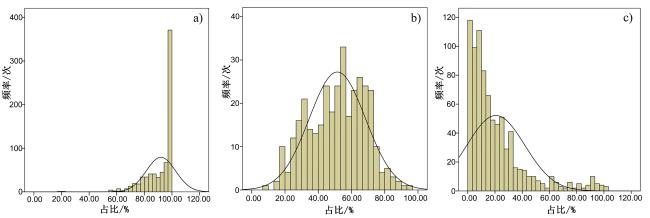
表2 广州市城市、城乡接合部和乡村建设用地占比分析Table 2 Analysis of the proportion of urban, urban-rural fringe, and rural construction land in Guangzhou |
| 项目 | 城市 | 城乡接合部 | 乡村 | |
|---|---|---|---|---|
| 个案数/个 | 753 | 350 | 856 | |
| 占比平均值/% | 92.01 | 51.50 | 20.64 | |
| 中位数/% | 97.21 | 53.30 | 13.55 | |
| 占比方差 | 0.01 | 0.03 | 0.05 | |
| 占比最小值/% | 18.00 | 9.00 | 0.00 | |
| 占比最大值/% | 100.00 | 95.00 | 100.00 | |
| 占比四分位数/% | 25 | 85.90 | 38.61 | 6.33 |
| 50 | 97.21 | 53.30 | 13.55 | |
| 75 | 100.00 | 65.45 | 27.01 | |

1 数据来源:广州市统计局(https://tjj.gz.gov.cn/)。
2 广州市“第三次国土调查”采用0.1 m分辨率的高精度航空影像作为调查底图,采取了多种措施支撑工作精细化管理。于2019-01-31前已经形成城镇村庄内部细化调查、耕地及可调整地类调查、批准未建设用地调查、相关自然资源衔接、村级工业园调查等初步成果。因“三调”具体数据涉及保密,因此,本文对含有“三调”数据的具体边界和数据进行归一化处理。
3 “天地图”是国家测绘地理信息局建设的地理信息综合服务网站。集成了来自国家、省、市(县)各级测绘地理信息部门,以及相关政府部门、企事业单位、社会团体、公众的地理信息公共服务资源,向各类用户提供权威、标准、统一的在线地理信息综合服务。本文广州市村级行政边界来自于天地图·智慧广州时空信息云平台(https://guangdong.tianditu.gov.cn/guangzhou/smartgzsky/Map/Djcx)。
4 地籍子区是以行政村、居委会或街坊为基础结合明显地物划分的稳定区域。
方鹏飞:论文撰写、数据处理、空间界定方法构建与图表绘制;
罗震东:空间界定方法指导、论文审阅与修改;
张 佶:完善论文框架建构与数据提供,提出修改意见;
毕瑜菲:数据处理、图表制作与方法讨论。
|
曹义,罗震东,乔艺波. 2019. 边缘的集聚:长三角淘宝村的空间特征,趋势与规划应对. 上海城市规划,(5):22-28.
Cao Yi, Luo Zhendong, and Qiao Yibo. 2019. Agglomeration at the Edge: Spatial Characteristics, Trends, and Planning Responses of Taobao Village in the Yangtze River Delta. Shanghai Urban Planning Review, (5): 22-28.
|
|
陈贝贝. 2013. 无锡半城市化地区的空间范围识别. 地理研究,32(7):109-1219.
Chen Beibei. 2013. Identification of Spatial Scope in Semi Urbanized Areas of Wuxi. Geographical Research, 32 (7): 109-1219.
|
|
Bogue D J. 1953. Population Growth in Standard Metropolitan Areas, 1900-1950: With an Explanatory Analysis of Urbanized Areas. Washington D C: US Government Printing Office.
|
|
陈佑启. 1996. 北京城乡交错带土地利用问题与对策研究. 经济地理,16(4):46-50.
Chen Youqi. 1996. Research on Land Use Issues and Countermeasures in the Urban Rural Ecotone of Beijing. Economic Geography, 16 (4): 46-50.
|
|
程慧,刘玉亭. 2014. 从开发区建设到中国特色“边缘城市”发展——南沙的实证研究. 国际城市规划,29(4):39-45.
Cheng Hui, and Liu Yuting. 2014. From the Construction of Development Zones to the Development of "Marginal Cities" with Chinese Characteristics: An Empirical Study of Nansha. Urban Planning International, 29 (4): 39-45.
|
|
崔功豪,武进. 1990. 中国城市边缘区空间结构特征及其发展——以南京等城市为例. 地理学报,45(4):399-411.
Cui Gonghao, and Wu Jin. 1990. Spatial Structure Characteristics and Development of Urban Marginal Areas in China: Taking Nanjing and Other Cities as Examples. Acta Geographica Sinica, 45 (4): 399-411.
|
|
戴俊杰,董婧雯,杨晟,孙毅中. 2021. 基于空间突变特征的城市边缘区提取方法. 地球信息科学学报,23(8):1401-1421.
Dai Junjie, Dong Jingwen, Yang Sheng, and Sun Yizhong. 2021. A Method for Extracting Urban Marginal Areas Based on Spatial Mutation Features. Geo-Information Science, 23 (8): 1401-1421.
|
|
国务院. 2002. 国务院关于加强城乡规划监督管理的通知. (2002-05-15) [2021-11-23]. https://www.gov.cn/gongbao/content/2002/content_61538.htm.
The State Council. 2002. Notice of the State Council on Strengthening Supervision and Management of Urban and Rural Planning. (2002-05-15) [2021-11-23]. https://www.gov.cn/gongbao/content/2002/content_61538.htm.
|
|
国务院. 2006. 关于统计上划分城乡的暂行规定. (2006-03-10)[2022-10-15]. https://tjj.fj.gov.cn/ztzl/tjzs/tjbz/200806/t20080626_44273.htm. [The State Council. 2006. Interim Provisions on the Classification of Urban and Rural Areas in Statistics. (2006-03-10) [2022-10-15]. https://tjj.fj.gov.cn/ztzl/tjzs/tjbz/200806/t20080626_44273.htm.]
|
|
国务院. 2019. 中共中央国务院关于建立国土空间规划体系并监督实施的若干意见. (2019-05-23)[2021-11-23]. https://www.gov.cn/zhengce/2019-05/23/content_5394187.htm. [The State Council. 2019. Several Opinions of the Central Committee of the Communist Party of China and the State Council on Establishing a National Spatial Planning System and Supervising Its Implementation. (2019-05-23) [2021-11-23]. https://www.gov.cn/zhengce/2019-05/23/content_5394187.htm.]
|
|
广州市人民政府办公厅. 1988. 关于划分城区、城乡结合部管理范围意见. (1988-01-26) [2021-08-28]. http://www.law168.com.cn/doc/view?id=107274.
General Office of Guangzhou Municipal People's Government. 1988. Opinions on Dividing the Management Scope of Urban Areas and Urban-Rural Fringe Areas. (1988-01-26) [2021-08-28]. http://www.law168.com.cn/doc/view?id=107274.
|
|
顾朝林,陈田,丁金宏,虞蔚. 1993. 中国大城市边缘区特性研究. 地理学报,48(4):317-328.
Gu Chaolin, Chen Tian, Ding Jinhong, and Yu Wei. 1993. Research on the Characteristics of Marginal Areas in Large Cities in China. Acta Geographica Sinica, 48 (4): 317-328.
|
|
Gonçalves J, Gomes M. C, Ezequiel S, Moreira F, and Loupa-Ramos I. 2017. Differentiating Peri-Urban Areas: A Transdisciplinary Approach towards a Typology. Land Use Policy, 63(1): 331-341.
|
|
黄玫,张敏. 2022. “城区范围”概念解析及其确定方法探讨——以115个城市为实践对象. 城市规划,46(5):17-26.
Huang Mei, and Zhang Min. 2022. Analysis of the Concept of "Urban Area Scope" and Exploration of Its Determination Methods: With 115 Cities as Practical Objects. City Planning Review, 46 (5): 17-26.
|
|
Idczak, P. and Mrozik, K., 2018. Periurbanisation–evidence from Polish metropolitan areas. Economic and Environmental Studies, 18(1): 173-192.
|
|
雷诚,范凌云. 2010. 广州市城乡结合部土地配置的问题与对策——以番禺区为例. 城市问题,175(2):74-79.
Lei Cheng, and Fan Lingyun. 2010. Land Allocation Issues and Countermeasures in the Urban-Rural Fringe of Guangzhou City: Taking Panyu District as an Example. Urban Issues, 175 (2): 74-79.
|
|
廖霞,舒天衡,申立银,任一田,杨楠. 2021. 城乡融合背景下半城市化地区识别与演变研究——以苏州市为例. 地理科学进展,40(11):1847-1860.
Liao Xia, Shu Tianheng, Shen Liyin, Ren Yitian, and Yang Nan. 2021. Research on the Identification and Evolution of Semi Urbanized Areas under the Background of Urban Rural Integration: Taking Suzhou City as an Example. Progress in Geography, 40 (11): 1847-1860.
|
|
林坚,汤晓旭,黄斐玫,苗春蕾. 2007. 城乡结合部的地域识别与土地利用研究——以北京中心城地区为例. 城市规划,31(8):36-44.
Lin Jian, Tang Xiaoxu, Huang Feimei, and Miao Chunlei. 2007. Research on Regional Identification and Land Use in the Urban Rural Border Area: Taking the Central City of Beijing as an Example. City Planning Review, 31 (8): 36-44.
|
|
李宝山,栾立欣,刘学,刘聪,闫士忠. 2020. 面向规划管理的建成区划定方法研究——以长春市为例. 城乡规划,(4):43-51.
Li Baoshan, Luan Lixin, Liu Xue, Liu Cong, and Yan Shizhong. 2020. Research on the Method of Defining Built up Areas for Planning and Management: Taking Changchun City as an Example. Urban and Rural Planning, (4): 43-51.
|
|
刘君德,宋迎昌. 1998. 论制度创新与可持续发展:上海市城乡结合部的管理体制探索. 城市规划汇刊,(4):42-45.
Liu Junde, and Song Yingchang. 1998. On Institutional Innovation and Sustainable Development: Exploring the Management System of the Urban Rural fringe in Shanghai. Urban Planning Forum, (4): 42-45.
|
|
刘守英,龙婷玉. 2022. 城乡融合理论:阶段,特征与启示. 经济学动态,(3):21-34.
Liu Shouying, and Long Tingyu. 2022. Theory of Urban-Rural Integration: Stages, Characteristics, and Implications. Economic Perspectives, (3): 21-34.
|
|
陆海英,杨山,张婷,王军. 2004. 基于遥感的城乡结合部地域范围界定研究——以无锡市为例. 南京师大学报(自然科学版),27(2):98-102.
Lu Haiying, Yang Shan, Zhang Ting, and Wang Jun. 2004. Research on the Definition of Regional Scope of Urban Rural Border Areas Based on Remote Sensing: Taking Wuxi City as an Example. Journal of Nanjing Normal University(Natural Science Edition), 27 (2): 98-102.
|
|
陆希刚,王德,庞磊. 2020. 半城市地区空间模式初探:基于“六普”数据的上海市嘉定区案例研究. 城市规划学刊,(6):72-78.
Lu Xigang, Wang De, and Pang Lei. 2020. Preliminary Exploration of Spatial Patterns in Semi urban Areas: A Case Study of Jiading District, Shanghai Based on "Six Popularizations" Data. Urban Planning Forum, (6): 72-78.
|
|
Martin L, and Howarth P J. 1989. Change-Detection Accuracy Assessment Using SPOT Multispectral Imagery of the Rural-Urban Fringe. Remote Sensing of Environment, 30 (1): 55-66.
|
|
Myers R, and Beegle J. 1947. Delineation and Analysis of the Rural-Urban Fringe. Human Organization, 6(2): 14-22.
|
|
Mckain W C, and Burnight R G. 1953. From the Rural Point of View. Rural Sociology, 18 (2):108-120.
|
|
Mortoja M G, Tan Y, and Mayere S. 2020. What is the Most Suitable Methodological Approach to Demarcate Peri-Urban Areas?. A Systematic Review of the Literature. Land Use Policy, 95(10): 104-126.
|
|
Pagliacci F. 2017. Measuring EU Urban-Rural Continuum Through Fuzzy Logic. Tijdschrift voor economische en sociale geografie, 108(2): 157-174.
|
|
Peng J, Zhao S, Liu Y, and Tian L. 2016. Identifying the Urban-Rural Fringe Using Wavelet Transform and Kernel Density Estimation: A Case Study in Beijing City, China. Environmental Modelling & Software, 83(9): 286-302.
|
|
Pryor R J. 1968. Defining the Rural-Urban Fringe. Social Forces, 47(2): 202-208.
|
|
钱建平 .2007. 基于遥感和信息熵的城乡结合部范围界定——以荆州市为例. 长江流域资源与环境,16(4):451-451.
Qian Jianping. 2007. Based on Remote Sensing and Information Entropy, The Scope of Urban-Rural Fringe is Defined. Resources and Environment of the Yangtze River Basin, 16 (4): 451-455.
|
|
Russwurm L H. 1964. Expanding Urbanization in the London to Hamilton Area of Western Ontario: 1941-1961. Champaign: University of Illinois at Urbana-Champaign.
|
|
Smith T L. 1937. The Population of Louisiana: Its Composition and Changes. American Journal of Sociology, 44(5): 761-762.
|
|
王纪武,金一,李王鸣. 2015. 基于城市边缘区判定的城市地域空间结构研究——以杭州市为例. 城市规划,39(9):21-26.
Wang Jiwu, Jin Yi, and Li Wangming. 2015. Research on Urban Regional Spatial Structure Based on the Determination of Urban Marginal Areas - Taking Hangzhou City as an Example. City Planning Review, 39 (9): 21-26.
|
|
吴敬琏. 2019. 比较104//楼继伟. 破除城乡二元体制,推进供给侧结构性改革. 第五辑. 北京:中信出版社.
Wu Jinglian. 2019. Comparison 104. In: Lou Jiwei. Breaking the Urban-Rural Dual System and Promoting Supply Side Structural Reform. Volume 5. Beijing: CITIC Press.
|
|
杨浩,罗震东,张京祥. 2014. 从二元到三元:城乡统筹视角下的都市区空间重构. 国际城市规划,29(4):21-26.
Yang Hao, Luo Zhendong, and Zhang Jingxiang. 2014. From Binary to Ternary: Spatial Reconstruction of Urban Areas from the Perspective of Urban Rural Integration. Urban Planning International, 29 (4): 21-26.
|
|
杨志恒. 2010. 基于Ward法的区域空间聚类分析. 中国人口资源与环境,20(S1):382-386.
Yang Zhiheng. 2010. Regional Spatial Clustering Analysis Based on Ward Method. China Population Resources and Environment, 20 (S1): 382-386.
|
|
中华人民共和国自然资源部. 2021. 城区范围确定规程. (2021-05-08)[2023-01-16]. http://gi.mnr.gov.cn/202106/t20210621_2658597.html.
Ministry of Natural Resources of the People's Republic of China. 2021. Notice of the State Council on Issuing the Action Plan for Carbon Peak before 2030. (2021-05-08) [2022-01-16]. http://gi.mnr.gov.cn/202106/t20210621_2658597.html.
|
|
张磊,叶裕民,孙玥,陈蛟. 2019. 特大城市城乡结合部村庄分类研究与特征分析——以广州市农村地区为例. 城市规划,43(6):47-54.
Zhang Lei, Ye Yumin, Sun Yue, and Chen Jiao. 2019. Research on the Classification and Characteristic Analysis of Villages in the Urban Rural Area of Megacities: Taking Rural Areas of Guangzhou as an Example. City Planning Review, 43 (6): 47-54.
|
|
张立军,彭浩. 2017. 面板数据加权聚类分析方法研究. 统计与信息论坛,32(4):21-26.
Zhang Lijun, and Peng Hao. 2017. Research on Weighted Cluster Analysis Method of Panel Data Forum. Statistics & Information Forum, 32 (4): 21-26.
|
|
章文波,方修琦,张兰生. 1999. 利用遥感影像划分城乡过渡带方法的研究. 遥感学报,(3):199-202.
Zhang Wenbo, Fang Xiuqi, and Zhang Lansheng. 1999. Research on the Method of Dividing Urban Rural Transition Zones Using Remote Sensing Images. Journal of Remote Sensing, (3): 199-202.
|
|
周一星,史育龙. 1995. 建立中国城市的实体地域概念. 地理学报,50(4):289-301.
Zhou Yixing, and Shi Yulong. 1995. Establishing the Concept of Physical Regions for Chinese Cities. Acta Geographica Sinica, 50(4): 289-301.
|
/
| 〈 |
|
〉 |