
基于多源开放数据的城市非正式住区空间分布及趋势研究
|
朱静怡(1999—),女,江苏扬州人,硕士研究生,主要研究方向为城市化过程,(E-mail)zhujingyi0821@163.com; |
收稿日期: 2025-02-11
修回日期: 2025-05-01
网络出版日期: 2025-12-25
基金资助
国家自然科学基金项目(42161144003)
国家自然科学基金项目(41771140)
Spatial Distribution and Trend of Informal Settlements Based on Multi-Source Open Data
Received date: 2025-02-11
Revised date: 2025-05-01
Online published: 2025-12-25
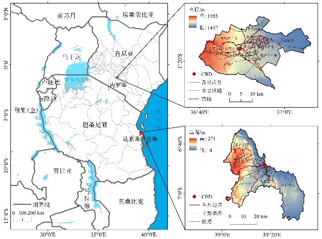
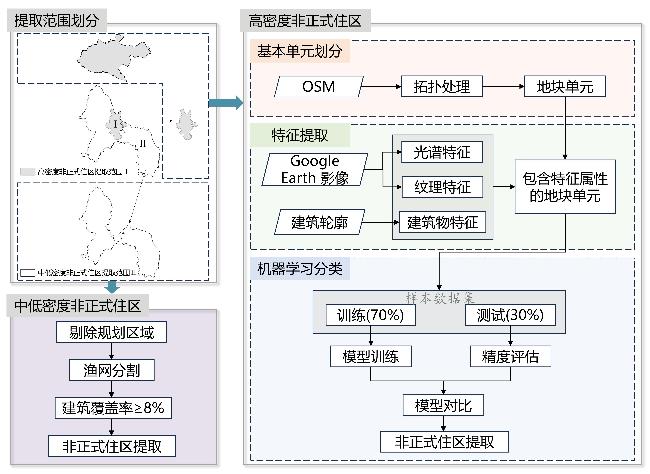
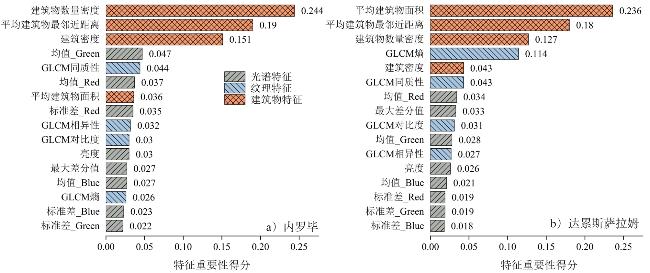
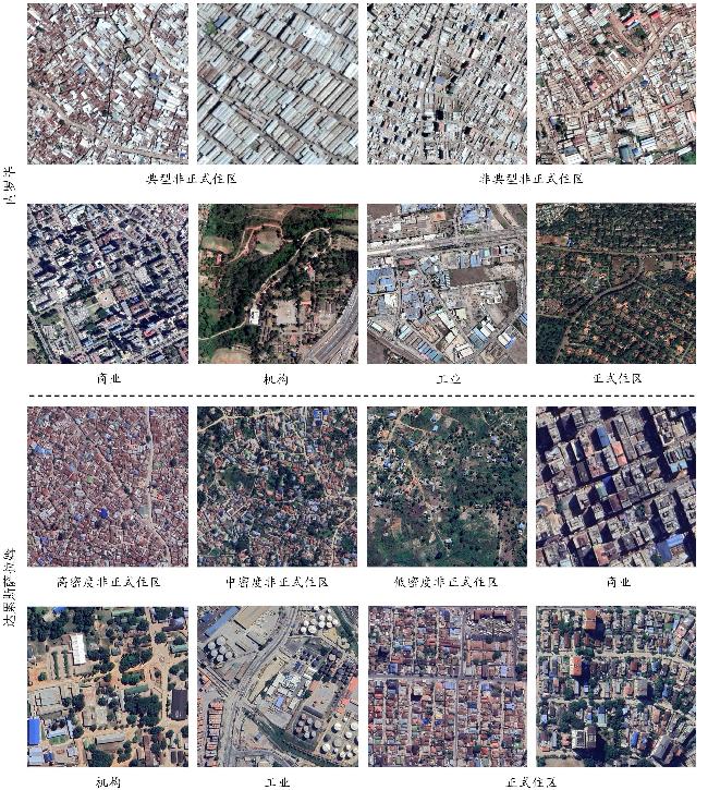
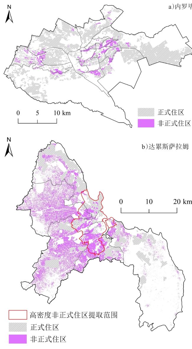
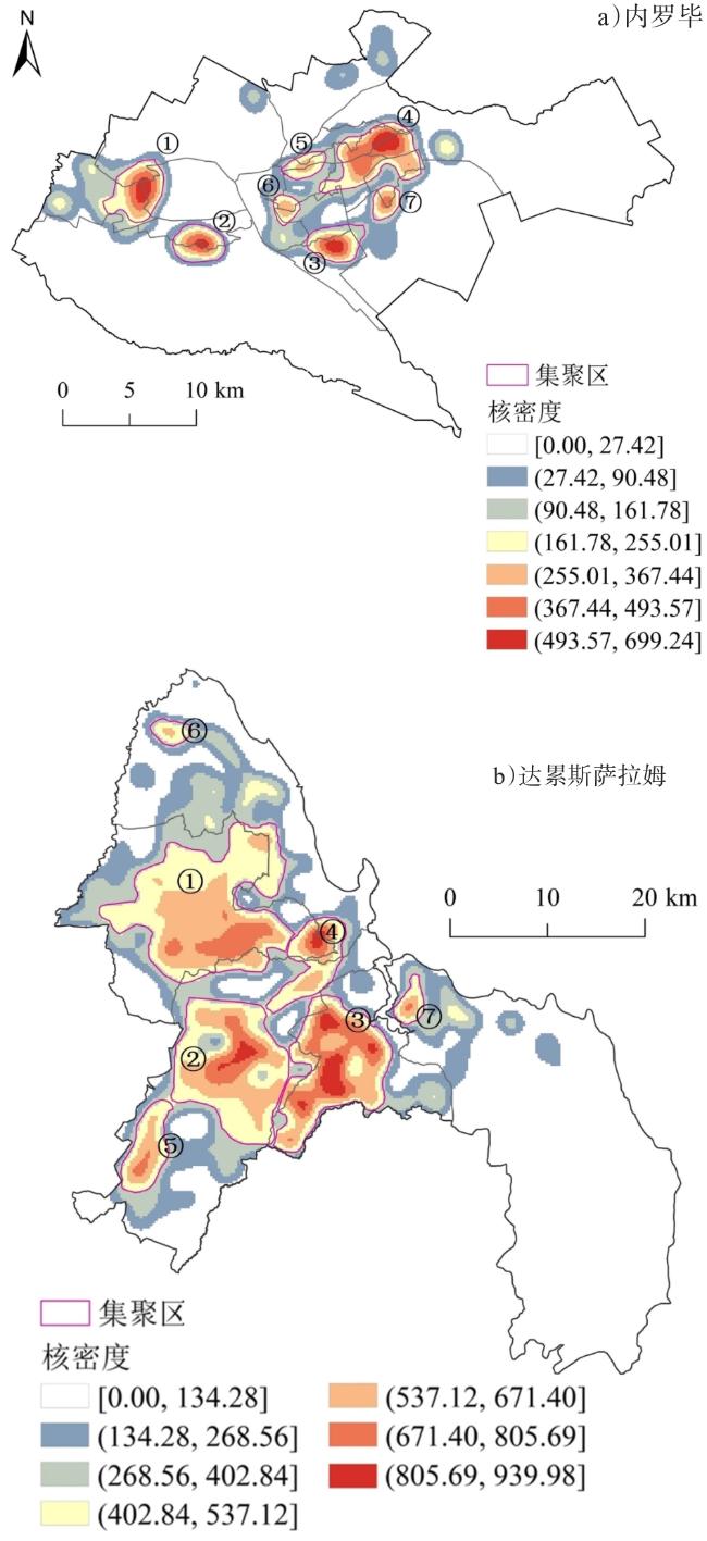
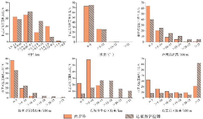
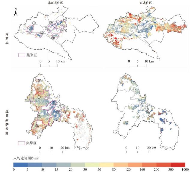
了解非正式住区的位置规模、分布规律和未来土地需求对于减少贫困、优化土地利用和促进城市可持续发展具有重要意义。文章以撒哈拉以南非洲城市内罗毕和达累斯萨拉姆为例,基于Google Earth高分辨率影像、OpenStreetMap数据和建筑轮廓数据,利用机器学习分类等方法识别非正式住区,进而探究其空间分布规律和趋势。结果表明:1)在3种机器学习算法中,随机森林算法在非正式住区提取上的总体表现优于逻辑回归和支持向量机,Kappa系数达85%;建筑物特征对分类的总贡献度超过50%,起最关键作用。2)内罗毕和达累斯萨拉姆的非正式住区占城市总面积的比例分别为3.64%和21.69%,2个城市各识别出7个明显的集聚区,人口规模分别为3.47万~31.35万人、2.93万~129.41万人。非正式住区主要分布在缓坡、主要道路和水系沿线地区,且多位于城市中心区5 km以外,但在工业指向性上内罗毕显著高于达累斯萨拉姆。3)内罗毕非正式住区人均建筑面积仅为达累斯萨拉姆的一半,其人口拥挤和房屋紧凑程度更为严重。预计至2050年,2座城市将面临日益严峻的土地资源紧张困境与住区正规化挑战。因此,非正式住区的改造与升级亟待立足长远,采取前瞻性策略加以推进。

朱静怡 , 陈爽 . 基于多源开放数据的城市非正式住区空间分布及趋势研究[J]. 热带地理, 2025 , 45(12) : 2265 -2280 . DOI: 10.13284/j.cnki.rddl.20250079
Informal settlements generally refer to low-quality residential areas built without government permission and characterized by poverty and insufficient basic services. Understanding their location, size, spatial distribution patterns, and future land demand is crucial for reducing poverty, optimizing land use, and promoting sustainable urban development. Using the sub-Saharan African cities of Nairobi and Dar es Salaam as case studies, based on multi-source open data, including Google Earth high-resolution imagery, OpenStreetMap data, and building footprint datasets, this study compared the performances of three machine learning classification methods (logistic regression, support vector machine, and random forest) in identifying informal settlements. After extracting informal settlements using the best-performing model, the spatial distribution patterns and trends of urban informal settlements in both cities were analyzed. Results showed the following: (1) The random forest model performed better than the support vector machine and logistic regression, exhibiting the highest overall accuracy and Kappa coefficient; hence, the random forest model had certain advantages in extracting informal settlements in different urban environments. The total contribution of four building features was greater than 50%, indicating that they played the most critical role in distinguishing informal settlements from other land types. (2) Informal settlements constitute 3.64% and 21.69% of the total areas of Nairobi and Dar es Salaam, respectively. Seven distinct agglomeration areas were identified in both Nairobi and Dar es Salaam, with population sizes of 34.7-313.5 and 29.3-1,294.1 thousand, respectively. In the two cities, informal settlements were mainly located in areas with gentle slopes, along rivers and main roads, and five kilometers away from the city center; however, informal settlements in Nairobi exhibited significantly higher industrial orientation than that in Dar es Salaam. (3) The population and building density of informal settlements in Nairobi were higher than those in Dar es Salaam, with the per capita building area in Nairobi being only half that of Dar es Salaam. This showed that the population congestion and housing compactness of informal settlements in Nairobi were more severe. With the increase of urban population, it is projected that by 2050, Nairobi and Dar es Salaam will add 30.26 and 169.96 km2 of informal built-up area, respectively. Under the prospect of informal settlement regularization, the future migrant population and corresponding land demand are expected to triple the current levels. In conclusion, we find a certain similarity in the spatial distribution patterns of informal settlements in Nairobi and Dar es Salaam; however, there are significant differences in their morphological patterns. In the future, both cities are expected to face increasing challenges, such as diminishing land resources and greater difficulties in regularizing informal settlements. Thus, informal settlements require targeted transformation and upgrading measures in combination with urban context differences and future development trends.
表1 特征及其描述Table 1 Features and descriptions |
| 特征类型 | 特征名称 | 特征描述 |
|---|---|---|
| 光谱特征 | 均值 | 各波段的光谱平均值 |
| 标准差 | 各波段的光谱标准差 | |
| 亮度 | 所有波段的亮度加权平均值 | |
| 最大差分值 | 所有波段的亮度差异最大值 | |
| 纹理特征 | 对比度 | 反映图像中局部灰度变化总量 |
| 同质性 | 度量图像局部灰度均匀性 | |
| 熵 | 表示图像中纹理的非均匀程度或复杂程度 | |
| 相异性 | 度量与对比度相类似,但为线性增加 | |
| 建筑物特征 | 平均建筑物面积/m² | 建筑屋顶总面积/建筑物数量,公式为: /n |
| 建筑密度/% | 建筑屋顶总面积/地块单元面积,公式为: /S | |
| 建筑物数量密度/个 | 单位公顷面积内建筑的数量,公式为:n/S | |
| 平均建筑物最邻近距离/m | 地块单元内建筑物质心到其最邻近建筑物质心距离的平均值,公式为: /n |
|
表2 各模型分类精度评价Table 2 Classification accuracy of different machine learning methods |
| 城市 | 模型 | 精度/% | ||||
|---|---|---|---|---|---|---|
| 精确率 | 召回率 | F 1分数 | 总体精度 | Kappa | ||
| 内罗毕 | LR | 93.22 | 87.30 | 90.16 | 94.57 | 86.42 |
| SVM | 86.51 | 87.20 | 86.85 | 92.53 | 81.64 | |
| RF | 91.20 | 90.48 | 90.84 | 94.80 | 87.20 | |
| 达累 斯萨 拉姆 | LR | 83.91 | 86.90 | 85.38 | 93.17 | 80.93 |
| SVM | 92.47 | 82.69 | 87.31 | 93.17 | 82.66 | |
| RF | 91.14 | 85.71 | 88.34 | 94.81 | 85.01 | |
表3 非正式住区集聚区人口规模Table 3 Population size of agglomeration areas in informal settlements |
| 城市 | 集聚区 | 人口/万人 |
|---|---|---|
| 内罗毕 | ① | 24.21 |
| ② | 17.87 | |
| ③ | 10.56 | |
| ④ | 31.35 | |
| ⑤ | 15.50 | |
| ⑥ | 3.47 | |
| ⑦ | 3.71 | |
| 达累斯萨拉姆 | ① | 66.48 |
| ② | 51.87 | |
| ③ | 129.41 | |
| ④ | 89.04 | |
| ⑤ | 7.25 | |
| ⑥ | 2.93 | |
| ⑦ | 3.73 |
表4 非正式与正式住区的密度估算结果Table 4 Density estimation results of informal and formal settlements |
| 城市 | 住区类型 | 人口密度/(人·km-2) | 建筑密度/% | 人均建筑面积/m2 |
|---|---|---|---|---|
| 内罗毕 | 非正式 | 47 534 | 52.10 | 10.96 |
| 正式 | 8 670 | 18.54 | 21.39 | |
| 达累斯萨拉姆 | 非正式 | 11 740 | 23.68 | 20.17 |
| 正式 | 6 085 | 11.78 | 19.40 |
|
表5 非正式住区集聚区密度估算结果Table 5 Density estimation results of agglomeration areas in informal settlements |
| 城市 | 集聚区 | 人口密度/(人·km-2) | 建筑密度/% | 人均建筑 面积/m2 |
|---|---|---|---|---|
| 内罗毕 | ① | 57 598 | 47.45 | 8.24 |
| ② | 76 152 | 61.38 | 8.06 | |
| ③ | 39 392 | 63.65 | 16.15 | |
| ④ | 43 633 | 51.66 | 11.84 | |
| ⑤ | 130 777 | 66.49 | 5.08 | |
| ⑥ | 35 249 | 47.56 | 13.49 | |
| ⑦ | 29 370 | 53.01 | 18.05 | |
| 达累斯 萨拉姆 | ① | 7 964 | 21.31 | 26.76 |
| ② | 8 946 | 21.53 | 24.07 | |
| ③ | 21 973 | 30.33 | 13.81 | |
| ④ | 46 517 | 44.94 | 9.66 | |
| ⑤ | 5 299 | 19.58 | 36.94 | |
| ⑥ | 7 476 | 24.46 | 32.71 | |
| ⑦ | 6 846 | 27.41 | 40.04 |
表6 建筑用地需求估算Table 6 Demand estimation of construction land |
| 年份 | 人口与建筑用地指标 | 内罗毕 | 达累斯 萨拉姆 |
|---|---|---|---|
| 2020 | 非正式住区人口/万人 | 123.24 | 414.93 |
| 密度合理化后人口迁移数量/万人 | 91.47 | 196.75 | |
| 密度合理化后人口迁移所需建筑面积/km² | 19.57 | 38.17 | |
| 2050 | 非正式住区人口/万人 | 399.30 | 1 257.56 |
| 新增非正式住区人口数量/万人 | 276.06 | 842.63 | |
| 新增非正式建筑面积/km² | 30.26 | 169.96 | |
| 密度合理化后人口迁移数量/万人 | 296.36 | 596.31 | |
| 密度合理化后人口迁移所需建筑面积/km² | 63.39 | 115.68 |
|
1 http://www.planning4adaptation.org-/Default.aspx
2 https://www.gadm.org/
3 https://www.nbs.go.tz/
4 https://geonode.resilienceacade-my.ac.tz/
5 https://www.openstreetmap.org/
6 http://earthexplorer.usgs.gov
7 https://www.worldpop.org/
朱静怡:研究方案设计,数据处理,论文撰写与修改;
陈 爽:概念构思,研究指导,论文审查与修改,项目支持。
|
Abebe F K. 2011. Modelling Informal Settlement Growth in Dar es Salaam, Tanzania. Enschede: University of Twente.
|
|
Amnesty International. 2009. Kenya: The Unseen Majority: Nairobi's Two Million Slum-Dwellers. (2009-06-12) [2024-11-02]. https://www.amnesty.org/en/documents/afr32/005/2009/en/.
|
|
Boanada-Fuchs A, Kuffer M, and Samper J. 2024. A Global Estimate of the Size and Location of Informal Settlements. Urban Science, 8(1): 18.
|
|
Breuer J H P and Friesen J. 2023. Methods to Assess Spatio-Temporal Changes of Slum Populations. Cities, 143: 104582.
|
|
Breuer J H P, Friesen J, Taubenböck H, Wurm M, and Pelz P F. 2024. The Unseen Population: Do We Underestimate Slum Dwellers in Cities of the Global South? Habitat International, 148: 103056.
|
|
崔成,赵璐,任红艳,逯伟利,黄耀欢. 2022. 耦合GF-2遥感影像与街景影像的广州市城中村识别. 遥感学报,26(9):1802-1813.
Cui Cheng, Zhao Lu, Ren Hongyan, Lu Weili, and Huang Yaohuan. 2022. Integrating High-Resolution Remote Sensing and Street View Images to Identify Urban Villages: A Case Study in Yuexiu District, Guangzhou City. National Remote Sensing Bulletin, 26(9): 1802-1813.
|
|
Dovey K, Van Oostrum M, Chatterjee I, and Shafique T. 2020. Towards A Morphogenesis of Informal Settlements. Habitat International, 104: 102240.
|
|
Duque J C, Patino J E, and Betancourt A. 2017. Exploring the Potential of Machine Learning for Automatic Slum Identification from VHR Imagery. Remote Sensing, 9(9): 895.
|
|
Fallatah A, Jones S, Mitchell D, and Kohli D. 2019. Mapping Informal Settlement Indicators Using Object-Oriented Analysis in the Middle East. International Journal of Digital Earth, 12(7): 802-824.
|
|
Friesen J, Taubenböck H, Wurm M, and Pelz P F. 2018. The Similar Size of Slums. Habitat International, 73: 79-88.
|
|
Graesser J, Cheriyadat A, Vatsavai R R, Chandola V, Long J, and Bright E. 2012. Image Based Characterization of Formal and Informal Neighborhoods in an Urban Landscape. IEEE Journal of Selected Topics in Applied Earth Observations and Remote Sensing, 5(4): 1164-1176.
|
|
Hofmann P, Strobl J, Blaschke T, and Kux H. 2008. Detecting Informal Settlements from QuickBird Data in Rio de Janeiro Using an Object Based Approach. In: Blaschke T H, Lang S, Hay G J. Object-Based Image Analysis: Spatial Concepts for Knowledge-Driven Remote Sensing Applications. Berlin: Springer, 531-553.
|
|
Huang X, Liu H, and Zhang L. 2015. Spatiotemporal Detection and Analysis of Urban Villages in Mega City Regions of China Using High-Resolution Remotely Sensed Imagery. IEEE Transactions on Geoscience and Remote Sensing, 53(7): 3639-3657.
|
|
黄正骊. 2018. 非洲当代城市中的贫民窟与非正规社区:以内罗毕为例. 国际城市规划,33(5):62-69.
Huang Zhengli. 2018. Slums and Informal Settlements in Contemporary African Cities: Nairobi as A Case Study. Urban Planning International, 33(5): 62-69.
|
|
Institute for Economics & Peace. 2023. Ecological Threat Report 2023: Analysing Ecological Threats, Resilience & Peace. (2023-10-31) [2024-11-02]. https://www.economicsandpeace.org/reports.
|
|
Kit O, Lüdeke M, and Reckien D. 2012. Texture-Based Identification of Urban Slums in Hyderabad, India Using Remote Sensing Data. Applied Geography, 32(2): 660-667.
|
|
Kohli D, Sliuzas R, Kerle N, and Stein A. 2012. An Ontology of Slums for Image-Based Classification. Computers, Environment and Urban Systems, 36(2): 154-163.
|
|
Kohli D, Warwadekar P, Kerle N, Sliuzas R, and Stein A. 2013. Transferability of Object-Oriented Image Analysis Methods for Slum Identification. Remote Sensing, 5(9): 4209-4228.
|
|
Kombe W J. 2005. Land Use Dynamics in Peri-Urban Areas and Their Implications on the Urban Growth and Form: The Case of Dar es Salaam, Tanzania. Habitat International, 29(1): 113-135.
|
|
Kombe W J and Muheirwe F. 2025. Dar es Salaam: City Report. (2025-01-30) [2025-04-15]. https://papers.ssrn.com/sol3/papers.cfm?abstract_id=5112868.
|
|
Kuffer M and Barrosb J. 2011. Urban Morphology of Unplanned Settlements: The Use of Spatial Metrics in VHR Remotely Sensed Images. Procedia Environmental Sciences, 7: 152-157.
|
|
Kuffer M, Orina F, Sliuzas R, and Taubenböck H. 2017. Spatial Patterns of Slums: Comparing African and Asian Cities. In: IEEE. 2017 IEEE Joint Urban Remote Sensing Event (JURSE). Dubai: IEEE, 1-4.
|
|
Lai F and Yang X. 2020. Integrating Spectral and Non-Spectral Data to Improve Urban Settlement Mapping in A Large Latin-American City. GIScience & Remote Sensing, 57(6): 830-844.
|
|
Liu X, He J, Yao Y, Zhang J, Liang H, Wang H, and Hong Y. 2017. Classifying Urban Land Use by Integrating Remote Sensing and Social Media Data. International Journal of Geographical Information Science, 31(8): 1675-1696.
|
|
Manara M. 2022. From Policy to Institution: Implementing Land Reform in Dar es Salaam's Unplanned Settlements. Environment and Planning A: Economy and Space, 54(7): 1368-1390.
|
|
Matarira D, Mutanga O, and Naidu M. 2022. Texture Analysis Approaches in Modelling Informal Settlements: A Review. Geocarto International, 37(26): 13451-13478.
|
|
Matarira D, Mutanga O, Naidu M, and Vizzari M. 2022. Object-Based Informal Settlement Mapping in Google Earth Engine Using the Integration of Sentinel-1, Sentinel-2, and PlanetScope Satellite Data. Land, 12(1): 99.
|
|
Mottelson J and Venerandi A. 2020. A Fine-Grain Multi-Indicator Analysis of the Urban Form of Five Informal Settlements in East Africa. Urban Science, 4(3): 31.
|
|
Niebergall S, Loew A, and Mauser W. 2008. Integrative Assessment of Informal Settlements Using VHR Remote Sensing Data—The Delhi Case Study. IEEE Journal of Selected Topics in Applied Earth Observations and Remote Sensing, 1(3): 193-205.
|
|
Owen K K and Wong D W. 2013. An Approach to Differentiate Informal Settlements Using Spectral, Texture, Geomorphology and Road Accessibility Metrics. Applied Geography, 38: 107-118.
|
|
Peng F, Lu W, Hu Y, and Jiang L. 2023. Mapping Slums in Mumbai, India, Using Sentinel-2 Imagery: Evaluating Composite Slum Spectral Indices(CSSIs). Remote Sensing, 15(19): 4671.
|
|
Persello C and Stein A. 2017. Deep Fully Convolutional Networks for the Detection of Informal Settlements in VHR Images. IEEE Geoscience and Remote Sensing Letters, 14(12): 2325-2329.
|
|
Quaye I, Amponsah O, Azunre G A, Takyi S A, and Braimah I. 2022. A Review of Experimental Informal Urbanism Initiatives and Their Implications for Sub-Saharan Africa's Sustainable Cities' Agenda. Sustainable Cities and Society, 83: 103938.
|
|
Ren H, Guo W, Zhang Z, Kisovi L M, and Das P. 2020. Population Density and Spatial Patterns of Informal Settlements in Nairobi, Kenya. Sustainability, 12(18): 7717.
|
|
Thomson D R, Gaughan A E, Stevens F R, Yetman G, Elias P, and Chen R. 2021. Evaluating The Accuracy of Gridded Population Estimates in Slums: A Case Study in Nigeria and Kenya. Urban Science, 5(2): 48.
|
|
Tu W, Chen D, Cao R, Xia J, Zhang Y, and Li Q. 2024. Towards SDG 11: Large-Scale Geographic and Demographic Characterisation of Informal Settlements Fusing Remote Sensing, POI, and Open Geo-Data. ISPRS Journal of Photogrammetry and Remote Sensing, 217: 199-215.
|
|
UN-Habitat. 2009. Tanzania: Dar es Salaam City Profile. (2009-08-04) [2024-09-29]. https://unhabitat.org/sites/default/files/download-manager-files/Tanzania%20Dar%20es%20Salaam%20Urban%20Profile.pdf.
|
|
UN-Habitat. 2010. Citywide Action Plan for Upgrading Unplanned and Unserviced Settlements in Dar es Salaam. (2021-03-04) [2024-10-02]. https://unhabitat.org/citywide-action-plan-for-upgrading-unplanned-and-unserviced-settlements-in-dar-es-salaam.
|
|
UN-Habitat. 2015. Habitat III Issue Papers 22-Informal Settlements. (2020-08-14) [2024-10-12]. https://unece.org/hlm/documents/2020/08/working-documents/habitat-iii-issue-paper-2-informal-settlements.
|
|
Un-Habitat. 2022. Global Action Plan: Accelerating for Transforming Informal Settlements and Slums by 2030. (2023-05-22) [2024-09-30]. https://unhabitat.org/sites/default/files/2023/05/global_action_plan_22-05-23.pdf.
|
|
United Republic of Tanzania. 2016. Dar es Salaam City Master Plan 2016-2036 Volume 1 Main Report Dar es salaam. (2018-10-24) [2024-10-15]. https://www.scribd.com/document/576454376/Dar-Es-Salaam-Tanzania-City-Plan-v.
|
|
Venerandi A, Iovene M, and Fusco G. 2021. Exploring the Similarities Between Informal and Medieval Settlements: A Methodology and an Application. Cities, 115: 103211.
|
|
Wekesa B W, Steyn G S, and Otieno F A O F. 2011. A Review of Physical and Socio-Economic Characteristics and Intervention Approaches of Informal Settlements. Habitat International, 35(2): 238-245.
|
|
张家旗. 2021. 坦桑尼亚城市发展与空间形态研究. 武汉:湖北科学技术出版社.
Zhang Jiaqi. 2021. Study on the Development and Spatial Form of Urban Areas in Tanzania. Wuhan: Hubei Science and Technology Press.
|
|
张家旗,陈爽,高群,Kimirei I A. 2019. 非正式聚落快速增长下的城市蔓延——以坦桑尼亚姆万扎市为例. 世界地理研究,28(3):32-42.
Zhang Jiaqi, Chen Shuang, Gao Qun, and Kimirei I A. 2019. Urban Sprawl under the Rapid Growth of Informal Settlements—A Case Study of Mwanza City, Tanzania. World Regional Studies, 28(3): 32-42.
|
|
张家旗,陈爽,Mapunda D W. 2018. 2002—2012年达累斯萨拉姆城市蔓延特征及影响因素. 中国科学院大学学报,35(5):663-673.
Zhang Jiaqi, Chen Shuang, and Mapunda D W. 2018. Characteristics and Influence Factors of Urban Sprawl of Dar es Salaam from 2002 to 2012. Journal of University of Chinese Academy of Sciences, 35(5): 663-673.
|
|
张涛,丁乐乐,史芙蓉. 2021. 高分辨率遥感影像城中村提取的景观语义指数方法. 测绘学报,50(1):97-104.
Zhang Tao, Ding Lele, and Shi Furong. 2021. Urban Villages Extraction from High-Resolution Remote Sensing Imagery Based on Landscape Semantic Metrics. Acta Geodaetica et Cartographica Sinica, 50(1): 97-104.
|
|
赵梓彤,陈水森,于国荣,李丹,贾凯,赵晨尧,李健,秦伯雄. 2024. 基于近期密集卫星数据的北江流域森林砍伐遥感方法. 热带地理,44(11):2091-2103.
Zhao Zitong, Chen Shuisen, Yu Guorong, Li Dan, Jia Kai, Zhao Chenrao, Li Jian, and Qin Boxiong. 2024. Remote Sensing Method of Forest Logging in the Beijiang River Basin Based on Recent Intensive Satellite Data. Tropical Geography, 44(11): 2091-2103.
|
/
| 〈 |
|
〉 |