
The Design and Implementation of a Virtual Reality Based Geographical Environment Monitoring System for a Remote Island
Received date: 2019-03-07
Request revised date: 2019-07-25
Online published: 2019-11-08
Copyright
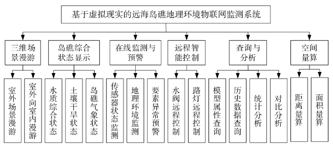
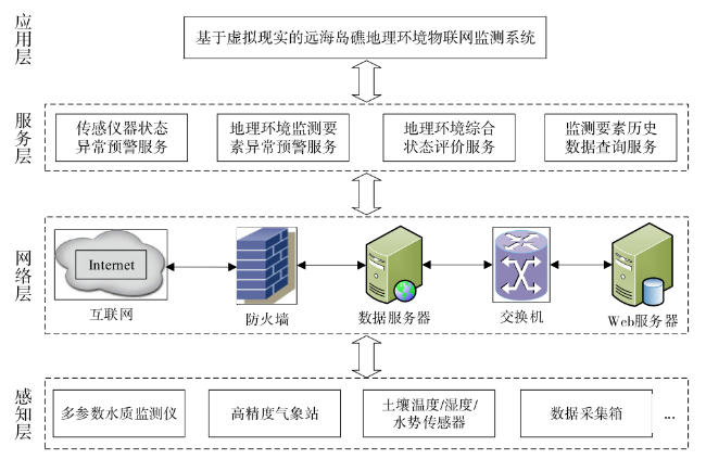
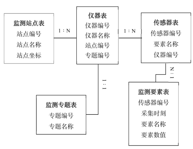
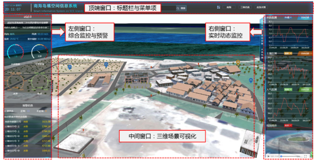
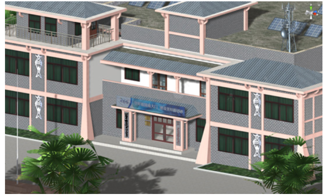
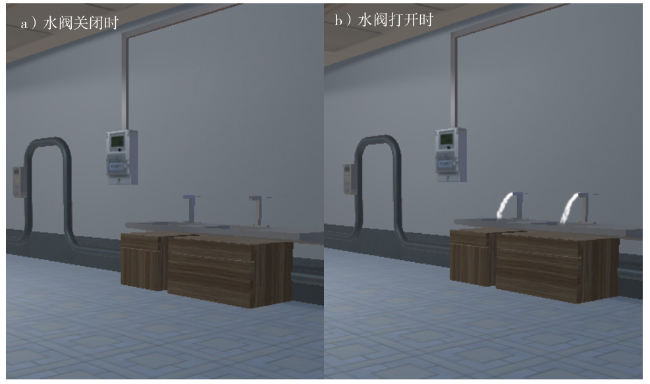
This study analyzes the present technologies related to environment sensing and intelligent crisis response, and integrates Virtual Reality (VR) and Internet of Things (IoT) technologies to implement a real-time geographical environment monitoring system aimed at solving the real-time monitoring and intelligent reaction needs of the ecological monitoring and protection of a remote island. The system adopts Browser/Server (B/S) architecture that contains four layers, a sensor layer, network layer, service layer, and application layer, forming complete technical processes beginning with data perception, data transmission, and data computation and finalizing in data application. Tables are designed according to environmental monitoring sensors that are mainly utilized in the water, soil, meteorology, and vegetation monitoring, thus achieving a unified storage and management system of multi-source heterogeneous sensor data. IoT technology is adopted to connect the sensors, servers, and computers into a unified network that achieves wireless transmission and both the access and remote storage of geographical environment data (e.g. water, soil, air and biology) from which the dynamic changes of water quality in the harbor, soil drought in the thicket, and meteorology in the island area can be displayed and evaluated; in this manner an early warning for abnormal changes in the environment can be obtained. VR technology is used to navigate and perform operations in both the indoor and outdoor modeled and integrated island scenery. Moreover, by integrating VR and IoT technologies, remote control of the intelligent sensing device is achieved; for example, this control is applicable for vegetation watering valves and lights. Using this system, a manager can not only obtain real-time geographical environment data and identify any abnormal changes of environmental features, but also remotely control intelligent sensing devices. Consequently, manual management of the island is no longer needed, and working efficiency is improved.
Wenzhou Wu , Yu Zhang , Fenzhen Su . The Design and Implementation of a Virtual Reality Based Geographical Environment Monitoring System for a Remote Island[J]. Tropical Geography, 2019 , 39(5) : 742 -748 . DOI: 10.13284/j.cnki.rddl.003163

| 1 |
|
| 2 |
|
| 3 |
|
| 4 |
|
| 5 |
|
| 6 |
李德仁, 姚远, 邵振峰 . 2012. 海岛礁及周边复杂环境动态三维建模. 武汉大学学报(信息科学版), 37(11):1261-1265.
[
|
| 7 |
李景丽, 高玲 . 2017. 三维虚拟现实技术在煤炭分布远程网络监控系统设计. 科技通报, 33(1):97-100.
[
|
| 8 |
|
| 9 |
|
| 10 |
孙治贵, 王元胜, 张禄, 郭旺 . 2018. 北方设施农业气象灾害监测预警智能服务系统设计与实现. 农业工程学报, 34(23):149-156.
[
|
| 11 |
|
| 12 |
|
| 13 |
吴蔚, 苏天赟, 张君珏, 周林, 丁明, 贾贞 . 2015. 基于GIS的海岛规划管理系统设计与实现——以唐山市打网岗岛开发适宜性评价为例. 中国海洋大学学报(自然科学版), 45(4):122-129.
[
|
| 14 |
郗笃刚, 张哲, 赵忠东, 孟佳, 王耿峰 . 2010. 基于OSG的南海岛礁三维地理信息系统的设计与实现. 海洋测绘, 30(6):67-70.
[
|
| 15 |
徐建国, 肖海峰 . 2018. 基于大数据的智慧农业物联网系统实现. 软件导刊, 17(8):133-136,140.
[
|
| 16 |
|
| 17 |
|
| 18 |
张荷霞 . 2014. 南沙群岛岛礁战略价值评价研究. 南京:南京大学.
[
|
| 19 |
赵焕庭, 袁家义, 王丽荣 . 2015. 南海实现和谐之路. 热带地理, 35(5):687-700.
[
|
/
| 〈 |
|
〉 |