
Evolution of Coral Shingle Cays in the Nansha Islands during 2009-2017
Received date: 2019-10-11
Revised date: 2019-12-30
Online published: 2020-08-11
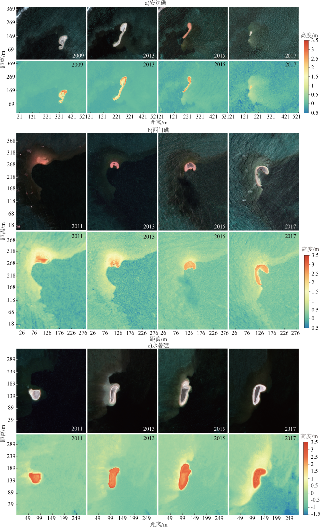
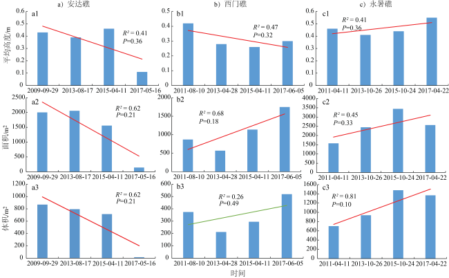
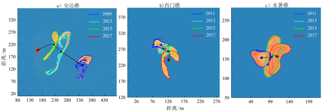
Coral shingle cays are distributed widely around coral reefs and islands in the South China Sea; however, their formation and evolution are little understood. A Digital Elevation Model (DEM) of three coral shingle cays at the Yongshu, Ximen, and Anda reefs, respectively, in the Nasha Islands had been built after they were investigated in 2017. Based on the modern DEMs of the shingle cays, different DEMs of the shingle cays were reconstructed at the past four intervals of 2011 (2009), 2013, 2015 and 2017 by remote sensing analysis; thus, the geomorphic features and evolution that the cays underwent from 2009-2017 was revealed. During this periods, the shingle cay at the Anda Reef experienced near constant erosion, shrinking continuously and showing losses of 50%, 70%, and 72% in average height, area, and volume, respectively, as part of a general declining trend. The shingle cay at the Yongshu Reef was dominated by horizontal and vertical accretions; its average height, area, and volume increased by approximately 21%, 62% and 103%, respectively, from 2011-2017. The area of the shingle cay at the Ximen Reef showed horizontal accretion, with an increase of approximately 160%, but its average height declined by approximately 31% and changes in its volume were insignificant. At both the Yongshu and Ximen reefs, the shingle cays moved eastward or southeastward into the lagoon or inner reef flat, with the centroid being displaced 41.18 m and 55.71 m, respectively; the average rates of movement were 0.6 m/month and 0.8 m/month, respectively. In contrast, the shingle cay at the Anda Reef moved northwestward towards the outer reef flat for a larger distance (193.1 m) and at a greater velocity (2.1 m/month) than the other reefs moved. The evolution of three shingle cays was controlled mainly by monsoon- and typhoon-driven waves, and was influenced by differences in hydrodynamics based on their locations and the shapes of the reef flat. As a result, the three shingle cays showed two different modes of evolution: migration and shrinking towards the outer reef flat and migration and extension into the lagoon or inner reef flat. The geomorphic evolution of these coral shingle cays in the Nansha Islands provides an important scientific basis for extensive study of the geomorphic development, and the dynamic mechanism thereof, of coral islands in the South China Sea. Further research will combine long-term remote sensing analysis and regular field observations of the ecology, sedimentology, and hydrodynamics of the coral shingle cays and neighboring reef areas, and focus on the long-term processes of coral shingle cay formation and evolution to reveal the key environmental factors thereof and the mechanisms affecting them.
Shengnan Zhou , Qi Shi , Huayu Guo , Hongqiang Yang , Hongqiang Yan . Evolution of Coral Shingle Cays in the Nansha Islands during 2009-2017[J]. Tropical Geography, 2020 , 40(4) : 694 -708 . DOI: 10.13284/j.cnki.rddl.003255
表1 3个珊瑚礁的卫星影像数据概况Table 1 Satellite images data for three coral reefs |
| 区域 | 卫星型号 | 影像分辨率/m | 波段 | 时间 |
|---|---|---|---|---|
| 安达礁 | GE-01 | 0.5 | 4 | 2009-09-29 |
| WV-02 | 0.5 | 8 | 2013-08-17 | |
| WV-03 | 0.3 | 8 | 2015-04-11 | |
| Pleiades | 0.5 | 4 | 2017-05-16 | |
| 西门礁 | QB-02 | 0.6 | 4 | 2011-08-10 |
| WV-02 | 0.5 | 8 | 2013-04-28 | |
| WV-03 | 0.3 | 8 | 2015-04-11 | |
| GE-01 | 0.5 | 4 | 2017-06-05 | |
| 永暑礁 | QB-02 | 0.6 | 4 | 2011-06-24 |
| Pleiades | 0.5 | 4 | 2013-10-26 | |
| WV-02 | 0.5 | 8 | 2015-10-24 | |
| Pleiades | 0.5 | 4 | 2017-04-22 |
表2 砾洲卫星影像多波段反射率与地形高度回归分析统计结果及遥感重建DEM与现场实测DEM误差参数Table 2 Statistical results of regression analysis between Multi-band reflectance of satellite images and height and the error parameters between the reconstructed DEM by remote sensing and measured DEM of the shingle cays at three coral reefs |
| 礁区 | 地貌带 | 数据量(N/pixel) | 拟合优度(R 2) | 平均绝对误差(MAE)/m | 平均相对误差(MRE)/% |
|---|---|---|---|---|---|
| 安达礁 | 砾洲 | 195 | 0.45*** | 0.26 | 15.6 |
| 礁坪 | 113 297 | 0.63*** | |||
| 西门礁 | 砾洲 | 9 726 | 0.56*** | 0.34 | 17.8 |
| 礁坪 | 445 134 | 0.73*** | |||
| 永暑礁 | 砾洲 | 9 853 | 0.54*** | 0.51 | 16.8 |
| 礁坪 | 312 301 | 0.85*** |
|
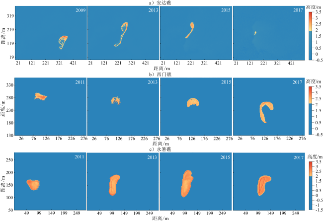
图3 4个时段遥感重建砾洲分布(基于MHWS)Fig.3 Distribution of three shingle cays reconstructed by remote sensing in four periods (based on the MHWS) |
表3 砾洲4个时段遥感重建DEM基本地形参数(基于MHWS)Table 3 Basic topographic parameters of three shingle cays reconstructed by remote sensing in four periods (based on the MHWS) |
| 礁区 | 时间 | 长度/m | 宽度/m | 长轴方向 | 短轴方向 | 平均 高度/m | 最大 高度/m | 外侧坡 度/(°) | 内侧坡 度/(°) | 面积/m2 | 体积/m3 |
|---|---|---|---|---|---|---|---|---|---|---|---|
| 安 达 礁 | 2009-09-29 | 106 | 46 | NE—SW | NW—SE | 0.43 | 1.53 | 26.4 | 13.6 | 2 005 | 869 |
| 2013-08-17 | 203 | 7 | NE—SW | NW—SE | 0.39 | 1.08 | 20.8 | 10.5 | 2 059 | 794 | |
| 2015-04-11 | 131 | 14 | NE—SW | NW—SE | 0.46 | 1.13 | 23.0 | 7.5 | 1 558 | 715 | |
| 2017-05-16 | 26 | 8 | NE—SW | NW—SE | 0.11 | 0.37 | 20.9 | 7.2 | 142 | 15 | |
| 西 门 礁 | 2011-08-10 | 44 | 19 | E—W | S—N | 0.42 | 0.86 | 13.3 | 10.5 | 871 | 374 |
| 2013-04-28 | 50 | 11 | E—W | S—N | 0.28 | 0.87 | 18.1 | 16.6 | 2 569 | 212 | |
| 2015-04-11 | 67 | 20 | E—W | S—N | 0.26 | 0.72 | 16.4 | 3.9 | 1 138 | 295 | |
| 2017-06-05 | 130 | 14 | S—N | E—W | 0.30 | 0.83 | 15.6 | 5.6 | 1 749 | 519 | |
| 永 暑 礁 | 2011-04-11 | 51 | 34 | E—W | S—N | 0.46 | 0.92 | 15.5 | 3.5 | 1 580 | 702 |
| 2013-10-26 | 88 | 28 | NNE—SSW | NWW—SEE | 0.41 | 1.21 | 29.4 | 6.7 | 2 448 | 938 | |
| 2015-10-24 | 110 | 34 | NNE—SSW | NWW—SEE | 0.44 | 1.01 | 22.1 | 5.3 | 3 443 | 1 479 | |
| 2017-04-22 | 102 | 28 | NE—SW | NW—SE | 0.55 | 1.37 | 15.0 | 6.7 | 2 566 | 1 369 |
表4 4个时段砾洲质心位移距离和方向Table 4 The moving distance and direction of centroid of three shingle cays in four periods |
| 时间 | 安达礁 | 时间 | 西门礁 | 时间 | 永暑礁 | |||||||||||
|---|---|---|---|---|---|---|---|---|---|---|---|---|---|---|---|---|
| 距离/m | 月速率/m | 方向 | 方位角/(°) | 距离/m | 月速率/m | 方向 | 方位角/(°) | 距离/m | 月速率/m | 方向 | 方位角/(°) | |||||
| 2009—2013年 | 109.55 | 2.4 | NW | 302.5 | 2011—2013年 | 16.26 | 0.8 | SE | 147.6 | 2011—2013年 | 28.48 | 0.9 | E | 85.9 | ||
| 2013—2015年 | 41 | 2.1 | NW | 316.8 | 2013—2015年 | 17.94 | 0.8 | SE | 116.3 | 2013—2015年 | 4.08 | 0.2 | N | 351.9 | ||
| 2015—2017年 | 68.16 | 2.7 | SW | 246.5 | 2015—2017年 | 29.27 | 1.1 | S | 184.1 | 2015—2017年 | 13.71 | 0.8 | SE | 104.6 | ||
| 2009—2017年 | 193.1 | 2.1 | NW | 288.6 | 2011—2017年 | 55.71 | 0.8 | SE | 156 | 2011—2017年 | 41.18 | 0.6 | E | 86.4 | ||

|
Aston J P.1995.The Relative Mobilities of Coral Cays on the Great Barrier Reef Can be Modeled.Townsville: James Cook University, 267.
|
|
暴景阳,许军,关海波.2013.平均大潮高潮面的计算方法与比较.海洋测绘,33(4):1-5.[Bao Jingyang, Xu Jun and Guan Haibo.2013.The Algorithms for Calculation of the Mean High Water Spring and Their Comparison.Hydrographic Surveying and Charting, 33(4): 1-5.]
|
|
Bayliss-Smith T P.1988.The Role of Hurricanes in the Development of Reef Islands, Ontong Java Atoll, Solomon Islands.Geographical Journal, 154(3): 377-391.
|
|
陈本清,杨燕明,罗凯.2017.基于高分一号卫星多光谱数据的岛礁周边浅海水深遥感反演.热带海洋学报,36(2):70-78.[Chen Benqing, Yang Yanming and Luo Kai.2017.Retrieval of Island Shallow Water Depth from The Gaofen-1 Multi-Spectral Imagery.Journal of Tropic Oceanography, 36(2): 70-78.]
|
|
Costa M B, Macedo E C and Siegle E.2017.Planimetric and Volumetric Changes of Reef Islands in Response to Wave Conditions.Earth Surface Processes and Landforms, 42(15): 2663-2678.
|
|
Costa M B, Macedo E C and Siegle E.2019.Wave Refraction and Reef Island Stability under Rising Sea Level.Global And Planetary Change, 172: 256-267.
|
|
Doxani G, Papadopoulou M, Lafazani P, Pikridas C and Tsakiri-Strati M.2012.Shallow-Water Bathymetry over Variable Bottom Types Using Multispectral Worldview-2 Image.International Archives of the Photogrammetry, Remote Sensing and Spatial Information Sciences, 39(8): 159-164.
|
|
Flood P G and Heatwole H.1986.Coral Cay Instability and Species-Turnover of Plants at Swain Reefs, Southern Great Barrier Reef, Australia.Journal of Coastal Research, 2(4): 479-496.
|
|
Ford M.2011.Shoreline Changes on an Urban Atoll in the Central Pacific Ocean: Majuro Atoll, Marshall Islands.Journal of Coastal Research, 28(1): 11-22.
|
|
Gourlay M R.1988.Coral Cays: Products of Wave Action and Geological Processes in a Biogenic Environment.Townsville: Proceedings of the 6th International Coral Reef Symposium, 2: 491-496.
|
|
Gourlay M R.1994.Wave Transformation on a Coral Reef.Coastal Engineering, 23: 17-42.
|
|
Gourlay M R.1996.Wave Set-Up on Coral Reefs: 1: Set-Up and Wave-Generated Flow on an Idealised Two Dimensional Horizontal Reef.Coastal Engineering, 27(3): 161-193.
|
|
郭晓雷,邱振戈,沈蔚,栾奎峰,曹斌才,吴忠强.2017.基于worldview-2遥感影像的龙湾港浅海水深反演.海洋学研究,35(3):27-32.[Guo Xiaolei, Qiu Zhenge, Shen Wei, Luan Kuifeng, Cao Bincai and Wu Zhongqiang.2017.Shallow Water Depth Inversion in Longwan Port Based on Worldview- 2 Remote Sensing Image.Journal of Marine Sciences, 35(3): 27-32.]
|
|
Hardyt A and Young I R.1996.Field Study of Wave Attenuation on an Offshore Coral Reef.Journal of Geophysical Research, 101(C6) :14311-14326.
|
|
Hedley J D, Harborne A R and Mumby P J.2005.Simple and Robust Removal of Sun Glint for Mapping Shallow-Water Benthos.International Journal of Remote Sensing, 26(10): 2107-2112.
|
|
Hochberg E J and Atkinson M J.2003.Capabilities of Remote Sensors to Classify Coral, Algae, and Sand as Pure and Mixed Spectra.Remote Sensing of Environment, 85(2): 174-189.
|
|
Hopley D.1978.Wheeler Reef: Cay Mobility.Geographical Studies of the Townsville Area, 2: 55-58.
|
|
Hopley D.2011.Encyclopedia of Modern Coral Reefs: Structure, Form and Process.The Netherlands: Springer.
|
|
Hopley D, Smithers S G and Parnell K.2007.The Geomorphology of the Great Barrier Reef: Development Diversity and Change.Cambridge: Cambridge University Press.
|
|
胡蕾秋,刘亚岚,任玉环,陈楚群,魏成阶.2010.Spot5多光谱图像对南沙珊瑚礁信息提取方法的探讨.遥感技术与应用,25(4):493-501.[Hu Leiqiu, Liu Yalan, Ren Yuhuan, Chen Chuqun and Wei Chengjie.2010.Research on the Extraction Method of Coral Reef at Spratly Islands Using Spot5.Remote Sensing Technology and Application, 25(4): 493-501.]
|
|
Jago O K, Kench P S and Brander R W.2007.Field Observations of Wave-Driven Water-Level Gradients across a Coral Reef Flat.Journal of Geophysical Research Oceans, 112( C6): 1496-1504.
|
|
Jiang H, Su F, Zhou C, Yang X, Wang Q and Cheng F.2018.The Geographical Characteristics of Nansha Islands in The South China Sea.Journal of Geographical Sciences, 28(7): 957-972.
|
|
康健,张杰,孟俊敏.2010.耀斑遥感图像均衡化的多项式拟合方法.中国海洋大学学报,40(6):36-40.[Kang Jian, Zhang Jie and Meng Junmin. 2010.A Polynomial Fitting Method of Sun Glitter Image Equalization.Periodical of Ocean University of China, 40(6): 36-40.]
|
|
Kayanne H, Aoki K, Suzuki T, Hongo C, Yamano H, Idey Y, Iwatsuka Y, Takahashi K, Katayama H, Sekimoto T and Isobe M.2016.Eco-Geomorphic Processes That Maintain a Small Coral Reef Island: Ballast Island in the Ryukyu Islands, Japan.Geomorphology, 271: 84-93.
|
|
Kench P S, Chan J, Owen S D and Mclean R F.2014.The Geomorphology, Development and Temporal Dynamics of Tepuka Island, Funafuti Atoll, Tuvalu.Geomorphology, 222(10): 46-58.
|
|
Kench P S, Brander R W, Parnell K P and Mclean R F.2006.Wave Energy Gradients across a Maldivian Atoll: Implications for Island Geomorphology.Geomorphology, 81(1/2): 1-17.
|
|
Kench P S, Parnell K E and Brander R W.2009.Monsoonally Influenced Circulation around Coral Reef Islands and Seasonal Dynamics of Reef Island Shorelines.Marine Geology, 266 (1/4): 91-108.
|
|
刘亮,姜小光,刘善伟,潘微,雷宇,张学华.2017.Worldview-2影像的水深探测能力.中国科学院大学学报,34(1):64-68.[Liu Liang, Jiang Xiaoguang, Liu Shanwei, Pan Wei, Lei Yu and Zhang Xuehua.2017.Water Depth Detection Ability of Worldview-2 Images.Journal of University of Chinese Academy, 34(1): 64-68.]
|
|
李龙龙,刘建强,邹斌.2015.基于worldview-2遥感影像反演浅海水深过程中太阳耀斑的去除方法.海洋预报,32(1):53-57.[Li Longlong, Liu Jianqiang and Zou Bin.2015.A Method to Remove Sun Glint in Depth Derivation from World View-2 Remote Sensing Images.Marine Forecast, 32(1): 53-57.]
|
|
黎满球,朱良生,隋世峰.2003.珊瑚礁坪波浪的衰减特性分析.海洋工程,21(2):71-75.[Li Manqiu, Zhu Liangsheng and Sui Shifeng.2003.Characteristics of Wave Attenuation on the Coral Reef.The Ocean Engineering, 21(2): 71-75.]
|
|
李秀瑞,朱金山,孙林.2016.Worldview-2影像在南海岛礁浅海水深反演中的应用.遥感信息,31(5):114-121.[Li Xiurui, Zhu Jinshan and Sun Lin.2016.Application of Worldview-2 Multispectral Image in Inversion of Shallow Water Bathymetry in South China Sea Reefs.Remote Sensing Information, 31(5): 114-121.]
|
|
廖彬彬,蔡永立,谢长坤,郝慧玲.2013.南海永兴岛珊瑚岛礁生境格局动态研究.海洋环境科学,32(5):746-751.[Liao Binbin, Cai Yongli, Xie Changkun and Hao Huiling.2013.Pattern and Dynamic of Habitats of Coral Reefs in Yongxing Island, South China Sea.Marine Environmental Science, 32(5): 746-751.]
|
|
柳淑学,刘宁,李金宣,方亚冰,刘思.2015.波浪在珊瑚礁地形上破碎特性试验研究.海洋工程,33(2):42-49.[Liu Shuxue, Liu Ning, Li Jinxuan, Fang Yabing and Liu Si.2015.Experimental Researches on Wave Propagation Characteristics on Reefs Terrain.The Ocean Engineering, 33(2): 42-49.]
|
|
刘永学,张忍顺,李满春.2004.质心分析法在小沙洲动态演化分析中的应用——以江苏辐射沙洲亮月沙为例.海洋通报,23(1):69-75.[Liu Yongxue, Zhang Renshun and Li Manchun.2004.Application of Centroid Method in Dynamic Changes of a Small Sandbank—A Case Study in Liangyuesha Sandbank of the Radial Sand Banks Offshore Jiangsu Province.Marine Science Bulletin, 23(1): 69-75.]
|
|
Lowe R J, Falter J L, Bandet M D, Pawlak G, Atkinson M J, Monismith S G and Koseff J R.2005.Spectral Wave Dissipation Over A Barrier Reef.Journal of Geophysical Research Oceans, 110(C4): 169-189.
|
|
Lyzenga D R.1978.Passive Remote Sensing Techniques for Mapping Water Depth and Bottom Features.Applied Optics, 17(3): 379-383.
|
|
Mandlier P G and Kench P S.2012.Analytical Modelling of Wave Refraction and Convergence on Coral Reef Platforms: Implications for Island Formation and Stability.Geomorphology, 159/160(4): 84-92.
|
|
Mclean R F.1980.Spatial and Temporal Variability of External Physical Controls on Small Island Ecosystems. In: Brookfield H C. Population Environment Relations in Tropical Islands: the Case of Eastern Fiji.Paris: UNESCO, 13: 149-175.
|
|
孟凡秋.2016.基于海洋遥感数据的岛礁特征提取方法研究.哈尔滨:哈尔滨工程大学.[Meng Fanqiu.2016.Research on Extracting Method of Reef Feature Based on Ocean Remote Sensing Data.Harbin: Harbin Engineering University.]
|
|
孟俊敏,张杰.2004.海洋动力过程光学遥感探测示例——水面舰船航速探测.海洋科学进展,22(Z1):55-59.[Meng Junmin and Zhang Jie. 2004.An Example of Optical Remote Sensing Detection of Ocean Dynamic Process-Speed Detection of Surface Ships.Advances in Marine Science, 22(Z1): 55-59.]
|
|
Monismith S G.2014.Flow Through A Rough, Shallow Reef.Coral Reefs, 33(1): 99-104.
|
|
Monismith S G, Rogers J S, Koweek D and Dunbar R B.2015.Frictional Wave Dissipation on a Remarkably Rough Reef.Geophysical Research Letters, 42(10): 4063-4071.
|
|
Perry C T, Kench P S, Smithers S G, Riegl B, Yamano H and O'leary M J.2011.Implications of Reef Ecosystem Change for the Stability and Maintenance of Coral Reef Islands.Global Change Biology, 17(12): 3679-3696.
|
|
Sandidge J C and Holyer R J.1998.Coastal Bathymetry from Hyperspectral Observations of Water Radiance.Remote Sensing of Environment, 65(3): 341-352.
|
|
Stumpf R P, Holderied K and Sinclair M.2003.Determination of Water Depth With High Resolution Satellite Imagery over Variable Bottom Types.Limnology and Oceanography, 48(1, part2): 547-556.
|
|
孙宗勋,赵焕庭.1995.南沙群岛环礁上的波能分布与地貌发育关系//中国地理学会地貌第四纪专业委员会.地貌•环境•发展.北京:中国环境科学出版社,141-145.[Sun Zongxun and Zhao Huanting.1995.Relationship between Wave Energy Distribution and Geomorphology Development on the Atolls in Nansha Islands.In: Quaternary Geomorphology Professional Committee of the Geographical Society of China.Geomorphology, Environment and Development.Beijing: China Environmental Science Press, 141-145.]
|
|
孙宗勋,赵焕庭.1996.南沙群岛珊瑚礁动力地貌特征.热带海洋学报,15(2):53-60.[Sun Zongxun and Zhao Huanting.1996.Features of Dynamic Geomorphology of Coral Reefs in Nansha Islands.Journal of Tropical Oceanography, 15(2): 53-60.]
|
|
王纪坤,陈正华,余克服,黄荣永,王英辉.2018.珊瑚礁区多光谱遥感水深反演研究.遥感技术与应用,33(1):61-67.[Wang Jikun, Chen Zhenghua, Yu Kefu, Huang Rongyong and Wang Yinghui.2018.Water Depth Information Extraction with Multi-Spectral Remote Sensing in Coral Reefs Region.Remote Sensing Technology and Application, 33(1): 61-67.]
|
|
王晶晶,田庆久.2007.海岸带浅海水深高光谱遥感反演方法研究.地理科学,27(6):843-848.[Wang Jingjing and Tian Qingjiu.2007.Study on Shallow Coastal Water Depth Derived Method Based on Hyperspectral Remote Sensing.Scientia Geographica Sinica, 27(6): 843-848.]
|
|
王绿卿,夏运强,梁丙臣,王海峰,杨锦凌.2019.南海灾害性波浪基本特征研究.海洋学报,41(3):23-34.[Wang Lvqing, Xia Yunqiang, Liang Bingchen, Wang Haifeng and Yang Jinling.2019.Basic Research on the Characteristics of Hazardous Waves in the South China Sea.Acta Oceanologica Sinica, 41(3): 23-34.]
|
|
王婷婷,梁广建,周兆黎,崔德杰,文爱平.2012.永暑海区波浪要素变化特征分析.海洋通报,31(3):278-282.[Wang Tingting, Liang Guangjian, Zhou Zhaoli, Cui Dejie and Wen Aiping.2012.Analysis of the Wave Characteristics at Yongshu Reef.Marine Science Bulletin, 31(3): 278-282.]
|
|
王燕红,陈义兰,周兴华,杨磊,付延光.2018.基于多项式回归模型的岛礁遥感浅海水深反演.海洋学报,40(3):121-128.[Wang Yanhong, Chen Yilan, Zhou Xinghua, Yang Lei and Fu Yanguang.2018.Research on Reef Bathymetry Using Based on Polynomial Regression Model.Acta Oceanologica Sinica, 40(3): 121-128.]
|
|
王艳姣.2006.基于悬浮泥沙影响的水深遥感方法研究.南京:南京师范大学.[Wang Yanjiao.2006.Application of Remote Sensing Technology to Map Water Depth by Weakening the Influence of Suspended Sediment.Nanjing: Nanjing Normal University.]
|
|
Webb A P and Kench P S.2010.The Dynamic Response of Reef Islands to Sea-Level Rise: Evidence from Multi-Decadal Analysis of Island Change in the Central Pacific.Global and Planetary Change, 72(3): 234-246.
|
|
吴忠强,沈蔚,郭晓雷,栾奎峰,邱振戈.2016.基于Worldview-2多光谱卫星数据的浅水水深遥感反演.海洋测绘,36(5):75-78.[Wu Zhongqiang, Shen Wei, Guo Xiaolei, Luan Kuifeng and Qiu Zhenge.2016.Shallow Water Depth Inversion Based on Worldview-2 Multispectral Data.Hydrographic Surveying and Charting, 36(5): 75-78.]
|
|
徐涵秋.2005.利用改进的归一化差异水体指数(MNDWI)提取水体信息的研究.遥感学报,9(5):589-595.[Xu Hanqiu.2005.A Study on Information Extraction of Water Body with the Modifiednormalized Difference Water Index (MNDWI).Journal of Remote Sensing, 9(5): 589-595.]
|
|
许家琨,刘雁春,许希启,翟国军,林有财,暴景阳,黄辰虎.2007.平均大潮高潮面的科学定位和现实描述.海洋测绘,27(6):19-24.[Xu Jiakun, Liu Yanchun, Xu Xiqi, Zhai Guojun, Lin Youcai, Bao Jingyang and Huang Chenhu.2007.Scientific Locating and Practical Descripting on Mean High Water Springs.Hydrographic Surveying and Charting, 27(6): 19-24.]
|
|
许林之.1987.南海波浪场的分析与预报.海洋预报,4(3):48-52.[Xu Linzhi.1987.Analysis and Prediction of Wave Field in The South China Sea.Marine Forecasts, 4(3): 48-52.]
|
|
姚宇,袁万成,杜睿超,蒋昌波.2015.岸礁礁冠对波浪传播变形及增水影响的实验研究.热带海洋学报,34(6):19-25.[Yao Yu, Yuan Wancheng, Du Ruichao and Jiang Changbo.2015.Experimental Study of Reef Crest’s Effects on Wave Transformation and Wave-Induced Setup over Fringing Reefs.Journal of Tropical Oceanography, 34(6): 19-25.]
|
|
姚宇,唐政江,杜睿超,蒋昌波.2017.珊瑚礁破碎带附近波浪演化和波生流实验研究.海洋科学,41(2):12-19.[Yao Yu, Tang Zhengjiang, Du Ruichao and Jiang Changbo.2017.Experimental Study of Wave Transformation And Wave-Driven Current around the Surf Zone Over Coral Reefs.Marine Sciences, 41(2): 12-19.]
|
|
姚宇,张起铭,蒋昌波.2019.礁面糙率变化下珊瑚礁海岸附近波浪传播变形试验.科学通报,64(9):977-985.[Yao Yu, Zhang Qiming and Jiang Changbo.2019.Laboratory Study of Wave Transformation around Reef Coasts with Various Rough Surfaces.Chinese Science Bulletin, 64(9): 977-985.]
|
|
易风,冯卫兵,曹海锦.2018.基于Era-Interim资料近37年南海波浪时空特征分析.海洋预报,35(1):44-51.[Yi Feng, Feng Weibing and Cao Haijin.2018.Wave Analysis Based on Era-Interim Reanalysis Data in the South China Sea.Marine Forecasts, 35(1): 44-51.]
|
|
赵焕庭,温孝胜,孙宗勋,郑德延.1996.南沙群岛珊瑚礁自然特征.海洋学报,18(5):61-70.[Zhao Huanting, Wen Xiaosheng, Sun Zongxun and Zheng Deyan.1996.Natural Characteristics of coral Reefs, Nansha Islands of South China Sea.Acta Oceanological Sinica, 18(5): 61-70.]
|
|
张惠军,刘龙威,王涛涛.2019.基于多源数据的南海海平面变化研究.测绘技术装备,21(3):23-27.[Zhang Huijun, Liu Longwei and Wang Taotao.2019.Study on Sea Level Change in the South China Sea Based on Multi-Source Data.Geomatics Technology and Equipment, 21(3): 23-27.]
|
|
张鹰,张东,王艳姣,许勇.2008.含沙水体水深遥感方法的研究.海洋学报,30(1):51-58.[Zhang Ying, Zhang Dong, Wang Yanjiao and Xu Yong.2008.Study of Remote Sensing-Based Bathymetric Method in Sand-Containing Water Bodies.Acta Oceanological Sinica, 30(1): 51-58.]
|
|
郑崇伟,周林,周立佳.2011.西沙、南沙海域波浪及波浪能季节变化特征.海洋科学进展,29(4):419-426.[Zheng Chongwei, Zhou Lin and Zhou Lijia.2011.Seasonal Variation of Wave and Wave Energy in Xisha and Nansha Sea Area.Advances in Marine Science, 29(4): 419-426.]
|
|
郑崇伟,周林.2012.近10年南海波候特征分析及波浪能研究.太阳能学报,33(8):1349-1356.[Zheng Chongwei and Zhou Lin.2012.Wave Climate and Wave Energy Analysis of the south China Sea in Recent 10 Years.Acta Energiae Solaris Sinica, 33(8): 1349-1356.]
|
|
郑崇伟,李崇银.2015.中国南海岛礁建设:重点岛礁的风候、波候特征分析.中国海洋大学学报(自然科学版),45(9):1-6.[Zheng Chongwei and Li Chongyin.2015.Development of the Islands and Reefs in the South China Sea: Wind Climate and Wave Climate Analysis.Periodical of Ocean University of China (Natural Science), 45(9): 1-6.]
|
|
郑逢斌,李坡涛,韩林果.2020.基于高分二号影像的城区水体提取方法研究.河南大学学报(自然科学版),50(2):213-220.[Zheng Fengbin, Li Potao and Han Linguo.2020.Study on Urban Water Extraction Based on GF-2 Image.Journal of Henan University (Natural Science), 50(2): 213-220.]
|
|
Zheng G, Chen F and Shen Y.2017.Detecting the Water Depth of the South China Sea Reef Area from Worldview-2 Satellite Imagery.Earth Science Informatics, 10(3): 331-337.
|
|
郑贵洲,乐校冬,王红平,花卫华.2017.基于Worldview-02高分影像的BP和RBF神经网络遥感水深反演.地球科学,42(12):2345-2353.[Zheng Guizhou, Le Xiaodong, Wang Hongping and Hua Weihua.2017.Inversion of Water Depth from Worldview-02 Satellite Imagery Based on BP and RBF Neural Network.Earth Science, 42(12): 2345-2353.]
|
|
钟晋樑,陈欣树,张乔民,孙宗勋.1996.南沙群岛珊瑚礁地貌研究.北京:科学出版社.[Zhong Jinliang, Chen Xinshu, Zhang Qiaomin and Sun Zongxun.1996.The Coral Reefs Landscape Research of Nansha Islands.Beijing: Science Press.]
|
|
周胜男,施祺,周桂盈,杨红强,严宏强.2019.南沙群岛珊瑚礁砾洲地貌特征.海洋科学,43(6):48-59.[Zhou Shengnan, Shi Qi, Zhou Guiying, Yang Hongqiang and Yan Hongqiang.2019.Geomorphic Features of Coral Shingle Cays in the Nansha Islands.Marine Sciences, 43(6): 48-59.]
|
|
Zhu H, Jiang X, Meng X, Feng Q, Cui S and Liang C.2016.A Quantitative Approach to Monitoring New Sand Cay Migration in Nansha Islands.Acta Oceanological Sinica, 35(3): 102-107.
|
|
宗芳伊,吴克俭.2014.基于近20年的SWAN模式海浪模拟结果的南海波浪能分布、变化研究.海洋湖沼通报,(3):1-12.[Zong Fangyi and Wu Kejian.2014.Research on Distributions and Variations of Wave Energy in South China Sea Based on Recent 20 Years’ Wave Simulation Results Using Swan Wave Model.Transaction of Oceanology and Limnology, (3): 1-12.]
|
/
| 〈 |
|
〉 |
