
The Risk of Heat Wave along the Jakarta-Bandung High-Speed Railway in Indonesia
Received date: 2020-04-15
Revised date: 2020-10-17
Online published: 2021-02-19
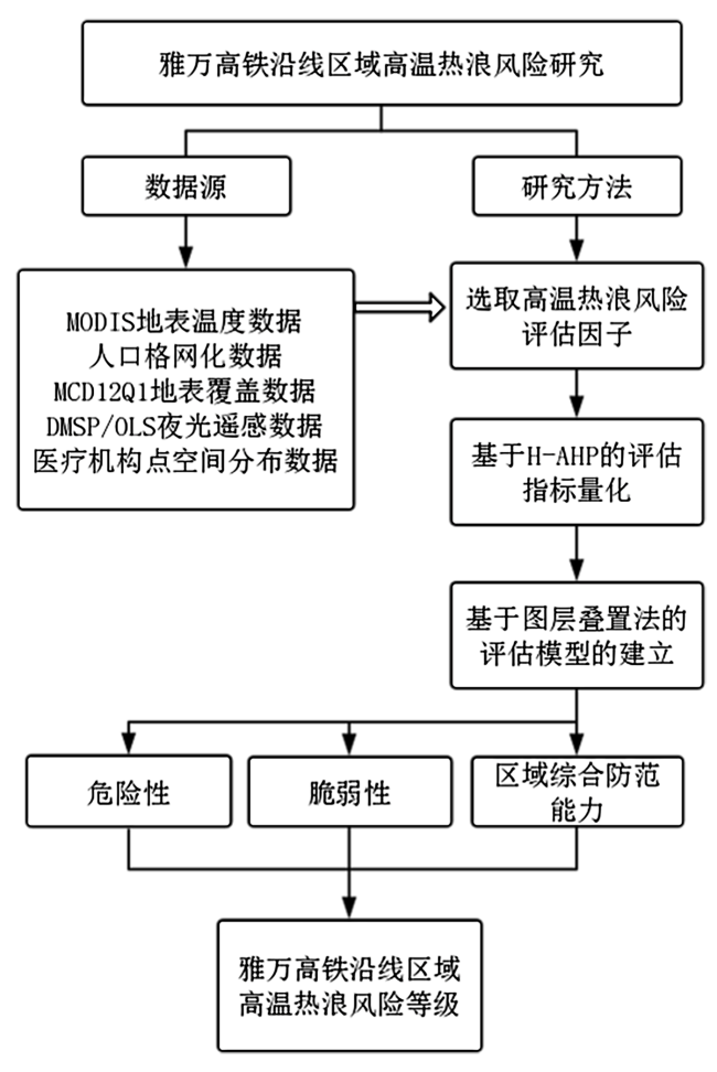
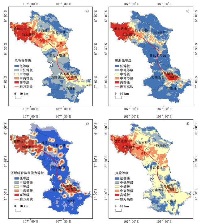
Since heat wave is currently one of the most important meteorological disasters, it has a significant impact on residents' health and social economy. The accurate identification and assessment of heat wave risk is an effective means to deal with this problem. In this paper, the hazard, vulnerability and regional comprehensive prevention ability factors were selected as the indexes for evaluating heat wave risk. The index weight was determined by the H-AHP method, and the spatial distribution map of the risk level of heat wave was calculated by the graph cascade method. The results show that there is a significant spatial difference in the risk of heat wave in the regions along the Jakarta-Bandung High-Speed railway. On the whole, the risk in the northern region is higher than that in the southern region, and the risk in the western region is higher than that in the eastern region. The high-risk areas are mainly concentrated in Jakarta, the capital of Indonesia. The medium-high-risk areas were mainly distributed in Jakarta's peripheral suburbs and Bandung City. The low-risk areas are distributed in the central region, forming a typical V-shaped distribution being high on both sides and low in the middle. The overall risk of heat wave in this region is at a medium level, with the medium-level risk area accounting for nearly 50%. With the exception of Jakarta, Bekasi, Bandung, and Cimahi cities, half or even more than half of the other counties are at medium-level risk. The area with low risk level accounts for the least, only 8.10%, mainly distributed in the northern part of Karawang county near the Java sea, and in the southwest part of Bandung county and West Bandung county with high forest coverage. In this paper, a method of heat wave risk assessment based on remote sensing is proposed, and spatial social and economic data are used, providing a new idea for heat wave risk assessment for countries along the Belt and Road region.
Xin Dai , Qingsheng Liu , Xilin Wu , Chong Huang , He Li . The Risk of Heat Wave along the Jakarta-Bandung High-Speed Railway in Indonesia[J]. Tropical Geography, 2021 , 41(1) : 147 -158 . DOI: 10.13284/j.cnki.rddl.003301
表1 判断矩阵1-9标度Table 1 1-9 scale of judgment matrix |
| 标度 | 意义 |
|---|---|
| 1 | 等同于 |
| 3 | 比较优于 |
| 5 | 很优于 |
| 7 | 非常优于 |
| 9 | 极端优于 |
| 1和9之间的其他标度 | 比较的中间值 |
表2 高温热浪风险评估层次结构Table 2 Hierarchical structure of the heat wave risk assessment |
| 目标层 | 准则层 | 指标层 | 指标层说明 |
|---|---|---|---|
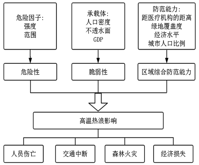
| 高温 热浪 风险A | 危险性B1 | 强度 C1 | 正向指标 |
| 范围 C2 | |||
| 脆弱性B2 | 人口密度 C3 | 正向指标 | |
| GDP C4 | |||
| 不透水面 C5 | |||
| 区域综合 防范能力B3 | 距医疗机构距离C6 | 负向指标 | |
| 绿地覆盖度C7 | |||
| 经济水平C8 | |||
| 城市人口比例C9 |
表3 准则层概率型犹豫积型偏好关系Table 3 The probabilistic dithering product preference relation of criterion layer |
| 准则层 | B1 | B2 | B3 |
|---|---|---|---|
| B1 | 1 | (8,6,7) | (7,5,5) |
| B2 | (1/8,1/6,1/7) | 1 | (5,4,1/4) |
| B3 | (1/7,1/5) | (1/5,1/4,4) | 1 |
表4 危险性指标层概率型犹豫积型偏好关系Table 4 The probabilistic dithering product preference relation of hazard indicator layer |
| 危险性 | C1 | C2 |
|---|---|---|
| C1 | 1 | (9,6,6) |
| C2 | (1/9,1/6,1/6) | 1 |
表5 脆弱性指标层概率型犹豫积型偏好关系Table 5 The probabilistic dithering product preference relation of vulnerability indicator layer |
| 脆弱性 | C3 | C4 | C5 |
|---|---|---|---|
| C3 | 1 | (9,1/4,1) | (1/7,1/5,1/6) |
| C4 | (1/9,4,1) | 1 | (1/8,1/6,1/6) |
| C5 | (7,5,6) | (8,6,6) | 1 |
表6 区域综合防范能力指标层概率型犹豫积型偏好关系Table 6 The probabilistic dithering product preference relation of regional comprehensive prevention ability indicator layer |
| 区域综合防范能力 | C6 | C7 | C8 | C9 |
|---|---|---|---|---|
| C6 | 1 | (8,4,5) | (7,4,4) | (6,4,1/5) |
| C7 | (1/8,1/4,1/5) | 1 | (1/5,1/3,1/5) | (7,1/3,1/4) |
| C8 | (1/7,1/4,1/4) | (5,3,5) | 1 | (6,1,1/4) |
| C9 | (1/6,1/4,5) | (1/7,3,4) | (1/6,1,4) | 1 |
表7 高温热浪风险评估各指标权重Table7 The weight of each indicator of heat wave risk assessment |
| 准则层指标 | 权重W | 指标层指标 | 权重W |
|---|---|---|---|
| 危险性 | 0.692 1 | 强度 | 0.875 |
| 范围 | 0.125 | ||
| 脆弱性 | 0.177 1 | 人口密度 | 0.682 3 |
| GDP | 0.183 9 | ||
| 不透水面 | 0.133 8 | ||
| 区域综合 防范能力 | 0.130 8 | 距医疗机构距离 | 0.583 6 |
| 绿地覆盖度 | 0.149 4 | ||
| 经济水平 | 0.17 | ||
| 城市人口比例 | 0.097 |

1 http://beta.sedac.ciesin.columbia.edu
2 https://www.ngdc.noaa.gov/eog/dmsp/downloadV4composites.html
|
包云,王娇娇,杜亚宇,赵方霞. 2019. 雅万高铁自然灾害及异物侵限监测系统解决方案. 铁路计算机应用,28(1):20-25. [Bao Yun, Wang Jiaojiao, Du Yayu and Zhao Fangxia. 2019. Solution of Natural Disasters and Foreign Intrusion Monitoring System for Jakarta-Bandung High-Speed Railway. Railway Computer Application, 28(1): 20-25. ]
|
|
陈倩,丁明军,杨续超,胡可嘉. 2017. 长江三角洲地区高温热浪人群健康风险评价. 地球信息科学学报,(11):1475-1484. [Chen Qian, Ding Mingjun, Yang Xuchao and Hu Kejia. 2017. Spatially Explicit Assessment of Heat Health Risks Using Multi-Source Data: A Case Study of the Yangtze River Delta Region, China. Journal of Geo-Information Science, (11): 1475-1484. ]
|
|
Dwirahmadi F, Rutherford S, Ulrich W and Chu C. 2013. Linking Disaster Risk Reduction and Climate Change Adaptation: A Good Practice Project in Jakarta, Indonesia. Hoboken, New Jersey, USA : John Wiley & Sons, Ltd..
|
|
Douglas J, Simpson A, Fraser S, Kuijper M, Winsemius H, Burzel A, Taillefer N, Vermooten S, Jacon F and Giraud P. 2017. ThinkHazard!-Identify Natural Hazards in Your Project Area and Understand how to Reduce Their Impact. Washington, USA: World Bank Group.
|
|
冯雷,李旭东. 2016. 高温热浪对人类健康影响的研究进展. 环境与健康杂志,33(2):182-188. [Feng Lei and Li Xudong. 2016. Research Progress on the Influence of High Temperature Heat Wave on Human Health. Journal of Environment and Health, 33(2): 182-188. ]
|
|
郭昱. 2018. 权重确定方法综述. 农村经济与科技,29(8):252-253. [Guo Yu. 2018. Weight Determination Method: A Review. Rural Economy and Science-Technology, 29(8): 252-253. ]
|
|
黄矛,马建华. 2008. 2003年欧洲热浪如何影响生态系统. 科学观察,3(1):61-62. [Huang Mao and Ma Jianhua. 2008. How the European Heat Wave Affected Ecosystems in 2003. Science Focus, 3(1): 61-62. ]
|
|
何苗,徐永明,李宁,白琳. 2017. 基于遥感的北京城市高温热浪风险评估. 生态环境学报,26(4):635-642. [He Miao, Xu Yongming, Li Ning and Bai Lin. 2017. Assessing Heat Wave Risk in Beijing by Remote Sensing. Ecology and Environmental Sciences, 26(4): 635-642. ]
|
|
贺山峰,戴尔阜,葛全胜,吴绍红,李明启. 2010. 中国高温致灾危险性时空格局预估. 自然灾害学报,19(2):91-97. [He Shanfeng, Dai Erfu, Ge Quansheng, Wu Shaohong and Li Mingqi. 2010. Pre-Estimation of Spatiotemporal Pattern of Extreme Heat Hazard in China. Journal of Natural Disasters, 19(2): 91-97. ]
|
|
Inostroza L, Palme M and Barrera F D L. 2016. A Heat Vulnerability Index: Spatial Patterns of Exposure, Sensitivity and Adaptive Capacity for Santiago de Chile. PLoS One, 11(9): e0162464.
|
|
IPPC. 2013. Working Group I Contribution to the IPCC Fifth Assessment Report Climate Change 2013: The Physical Science Basis. Cambridge & New York, USA: Cambridge University Press.
|
|
Johnson D P, Stanforth A, Lulla V and Luber G. 2012. Developing an Applied Extreme Heat Vulnerability Index Utilizing Socioeconomic and Environmental Data. Applied Geography, 35(1/2): 23-31.
|
|
Krvger T, Held F, Hoechstetter S, Goldberg V, Geyer T and Kurbjuhn C. 2013. A New Heat Sensitivity Index for Settlement Areas. Urban Climate, 6: 63-81.
|
|
李德仁,余涵若,李熙. 2017. 基于夜光遥感影像的“一带一路”沿线国家城市发展时空格局分析. 武汉大学学报(信息科学版),42(6):711-720. [Li Deren, Yu Hanruo and Li Xi. 2017. The Spatial-Temporal Pattern Analysis of City Development in Countries along the Belt and Road Initiative Based on Nighttime Light Data. Geomatics and Information Science of Wuhan University (Information Science Edition), 42(6): 711-720. ]
|
|
李京. 2017. 高温热浪对济南人群健康的影响及社区干预研究. 济南:山东大学. [Li Jing. 2017. High Temperature and Heatwave Effects on Human Health and Research of Community-Based Intervention in Jinan, China. Jinan: Shandong University. ]
|
|
鲁涓涓. 2019. 中国高铁“走出去”实践探析. 南京:南京大学. [Lu Juanjuan. 2019. Practice Analysis of Chinese High-Speed Railway's "Going Out". Nanjing: Nanjing University. ]
|
|
栾庆祖,叶彩华,刘勇洪,李书严,高燕虎. 2014. 城市绿地对周边热环境影响遥感研究——以北京为例. 生态环境学报,23(2):252-261. [Luan Qingzu, Ye Caihua, Liu Yonghong, Li Shuyan and Gao Yanhu. 2014. Effect of Urban Green Land on Thermal Environment of Surroundings Based on Remote Sensing: A Case Study in Beijing, China. Ecology and Environmental Sciences, 23(2): 252-261. ]
|
|
黎锁平. 2006. 运用蒙特卡罗方法求解随机性问题. 甘肃工业大学学报,27(6):595-596. [Li Suoping. 2006. Solution of Stochastic Problems with Monte-Carlo Method. Journal of Gansu University of Technology, 27(6): 595-596. ]
|
|
刘勇洪,权维俊. 2014. 北京城市高温遥感指标初探与时空格局分析. 气候与环境研究,19(3):332-342. [Liu Yonghong and Quan Weijun. 2014. Preliminary Study on High Temperature Remote Sensing Index and Analysis of Spatiotemporal Pattern in Beijing. Climate and Environmental Research, 19(3): 332-342. ]
|
|
Nasim W, Amin A, Fahad S, Awais M, Khan N, Mubeen M, Wahid A, Rehman M H and Ihsan M Z. 2018. Future Risk Assessment by Estimating Historical Heat Wave Trends with Projected Heat Accumulation Using SimCLIM Climate Model in Pakistan. Atmospheric Research, 205: 118-133.
|
|
Raei E, Nikoo M R, Aghakouchak A, Mazdiyasni O and Sadegh M. 2018. GHWR, A Multi-Method Global Heatwave and Warm-Spell Record and Toolbox. Scientific Data, 206: 1-15.
|
|
宋晨阳,张韧. 2016. 基于犹豫层次分析和云模型的我国沿海军港气候变化影响与风险评估. 军事运筹与系统工程,30(2):75-80. [Song Chenyang and Zhang Ren. 2016. Impact and Risk Assessment of Climate Change in Coastal Military Ports of China Based on Hesitant Hierarchy Process and Cloud Model. Military Operations Research and Systems Engineering, 30(2): 75-80. ]
|
|
史军,丁一汇,崔林丽. 2008. 华东地区夏季高温期的气候特征及其变化规律. 地理学报,12(4):372-375. [Shi Jun, Ding Yihui and Cui Linli. 2008. Climatic Characteristics and Their Changing Law during Summer High-Temperature Times in East China. Acta Geographica Sinica, 12(4): 372-375. ]
|
|
谭建国,黄家鑫. 2004. 热浪对人体健康的影响及其研究方法. 气候与环境研究,19(4):680-686. [Tan Jianguo and Huang Jiaxin. 2004. The Effect of Heat Waves on Human Health and Its Research Methods. Climate and Environmental Research, 19(4): 680-686. ]
|
|
王菲菲. 2018. “一带一路”背景下中国高铁外交研究——以中印尼雅万高铁为例. 长春:吉林大学. [Wang Feifei. 2018. Research on High-Speed Railway Diplomacy of China under the Background of the "Belt and Road" Based on Jakarta- Bandung High- Speed Railway between China and Indonesia. Changchun: Jilin University. ]
|
|
武夕琳,刘庆生,刘高焕,黄翀,李贺. 2019. 高温热浪风险评估研究综述. 地球信息科学学报,21(7):1029-1039. [Wu Xilin, Liu Qingsheng, Liu Gaohuan, Huang Chong and Li He. 2019. Risk Assessment of Heat Waves: A Review. Journal of Geo-Information Science, 21(7): 1029-1039. ]
|
|
王哲,葛珊珊,张韧,钱龙霞,杨孟倩,徐淦. 2017. 基于粗糙集与犹豫层次分析的北极东北航道风险评估. 海洋通报,36(5):512-520. [Wang Zhe, Ge Shanshan, Zhang Ren, Qian Longxia, Yang Mengqian and Xu Gan. 2017. Risk Assessment of the Northeast Passage of Arctic Based on Rough Set Theory and Hesitate Analytic Hierarchy Process. Marine Science Bulletin, 36(5): 512-520. ]
|
|
徐涵秋,王美雅. 2016. 地表不透水面信息遥感的主要方法分析. 遥感学报,20(5):1270-1289. [Xu Hanqiu and Wang Meiya. 2016. Remote Sensing-Based Retrieval of Ground Impervious Surfaces. Journal of Remote Sensing, 20(5): 1270-1289. ]
|
|
谢盼,王仰麟,彭建,刘焱序. 2015. 基于居民健康的城市高温热浪灾害脆弱性评价——研究进展与框架. 地理科学进展,34(2):165-174. [Xie Pan, Wang Yanglin, Peng Jian and Liu Yanxu. 2015. Health Related Urban Heat Wave Vulnerability Assessment: Research Progress and Framework. Progress in Geography, 34(2): 165-174. ]
|
|
Yin C, Yang F, Wang J and Ye Y X. 2020. Spatiotemporal Distribution and Risk Assessment of Heat Waves Based on Apparent Temperature in the One Belt and One Road Region. Remote Sensing, 12(7): 1174.
|
|
朱斌. 2014. 基于偏好关系决策方法及应用研究. 南京:东南大学. [Zhu Bin. 2014. Decision-Making Method Based on Preference Relationship and Its Application. Nanjing: Southeast University. ]
|
|
张继权,李宁. 2007. 主要气象灾害风险评价与管理的数量化方法及其应用. 北京:北京师范大学出版社.[Zhang Jiquan and Li Ning. 2007. Quantitative Methods and Application of Risk Assessment and Management of Major Meteorological Disaster. Beijing: Beijing Normal University Press. ]
|
|
张尚印,张德宽,徐祥德,廖要明,沈树勤,尹东屏. 2005. 长江中下游夏季高温灾害机理及预测. 南京气象学院学报,28(6):840-847. [Zhang Shangyin, Zhang Dekuan, Xu Xiangde, Liao Yaoming, Shen Shuqin and Yin Dongping. 2005. Study on the Mechanism and Forecasting Method of High Temperature Disaster in Summer in the Large Cities of the Yangtze River Basin. Journal of Nanjing Institute of Meteorology, 28(6): 840-847. ]
|
|
周洋,祝善友,华俊玮,刘祎,向嘉敏,丁文. 2018. 南京市高温热浪时空分布研究. 地球信息科学学报,20(11):1613-1621. [Zhou Yang, Zhu Shanyou, Hua Junwei, Liu Yi, Xiang Jiamin and Ding Wen. 2018. Spatial-Temporal Distribution of High Temperature Heat Wave in Nanjing. Journal of Geo-Information Science, 20(11): 1613-1621. ]
|
|
赵斗. 2018. 雅万高铁技术标准研究. 中国铁路,(12):7-14. [Zhao Dou. 2018. Study on the Technical Standards of Jakarta-Bandung High Speed Railway. China Railway, (12): 7-14. ]
|
|
赵颜创,赵小锋,刘乐乐. 2016. 厦门市高温热浪人群健康风险格局分析. 地球信息科学学报,18(8):1094-1102. [Zhao Yanchuang, Zhao Xiaofeng and Liu Lele. 2016. Spatial Pattern Analysis on Human Health Risk of Heatwave in Xiamen City. Journal of Geo-Information Science, 18(8): 1094-1102. ]
|
/
| 〈 |
|
〉 |

