
The Multi-Center Spatial Structure in the Guangdong-Hong Kong-Macao Greater Bay Area Urban Agglomeration Based on Luojia1-01 Nighttime Light Data and POI Data
Received date: 2021-09-11
Revised date: 2022-01-07
Online published: 2022-03-21
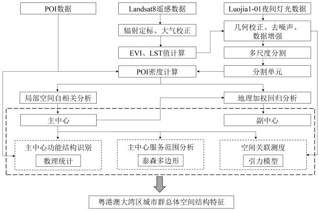
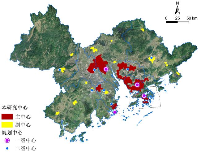
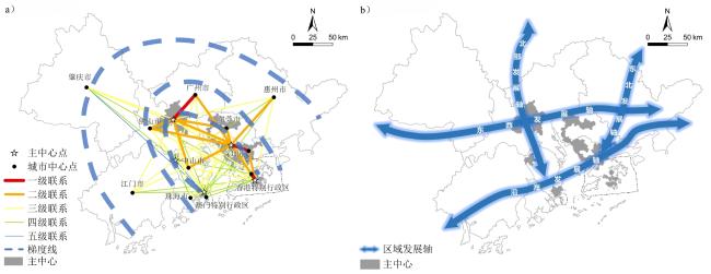
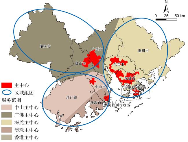
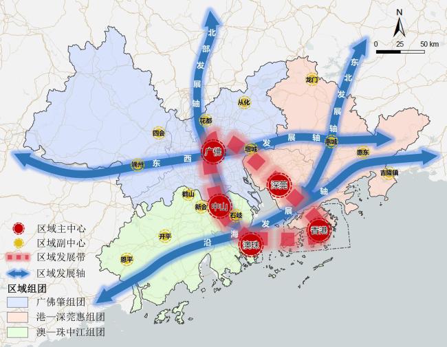
The Guangdong-Hong Kong-Macao Greater Bay Area (referred to as "GBA") is an important strategic deployment for China's current economic development. Clarifying the spatial structure characteristics of the GBA urban agglomeration is conducive to optimizing its spatial structure to develop into a multi-center network spatial structure and promoting coordinated regional development. This study uses the advantage of Luojia1-01 nighttime light data, which can distinguish the difference in urban night light intensity. Through multi-scale segmentation of nighttime light intensity, the potential center range is established. The point of interest (POI) data are used for spatial autocorrelation analysis and geographically weighted regression to identify the multi-center distribution of the GBA urban agglomeration, and to analyze its spatial structure characteristics from multiple perspectives such as functional structure identification, spatial correlation measurement, and main center service range. The following list illustrates what the results show. 1) The GBA has five main centers and 14 sub-centers, including the main centers of Guangfo, Shenguan, Hong Kong, Aozhu, and Zhongshan. The functional structures of the five main centers are mainly mixed functional areas, and 14 sub-centers (such as Huadu, Zengcheng, Conghua, Huicheng, Duanzhou, Xinhui, Shiqi) are distributed around the periphery of the main centers. 2) The correlation strength of the five main centers and nine cities plus two special administrative regions in the urban agglomeration, calculated based on the Luojia1-01 nighttime light data, shows characteristics of "strong in the east and weak in the west" and "strong inside and weak outside." 3) The study considered the distribution of the main centers of the urban agglomeration and their spatial correlation strength characteristics, as well as the three groups served by the main centers (Guangfozhao group, Gang-Shenguanhui group and Ao-Zhuzhongjiang group), combined with the planning requirements of the "Outline Development Plan for the Guangdong-Hong Kong-Macao Greater Bay Area" and "Guangdong Province Land and Space Planning (2020-2035)." The findings suggest that the GBA should build a regional spatial structure of "five centers, one area, three groups and four axes" to achieve pole-driven, axis-supported, and group cooperation and promote its coordinated development into a world-class urban agglomeration.
Qiuying Zhi , Jieying Chen , Yingchun Fu , Biyun Guo . The Multi-Center Spatial Structure in the Guangdong-Hong Kong-Macao Greater Bay Area Urban Agglomeration Based on Luojia1-01 Nighttime Light Data and POI Data[J]. Tropical Geography, 2022 , 42(3) : 444 -456 . DOI: 10.13284/j.cnki.rddl.003455
表1 不同夜间灯光数据参数比较Table 1 Comparison of different nighttime light data parameters |
| 夜光数据 名称 | 发射 国家 | 重访 周期 | 数据位数/bits | 空间分 辨率/m | 在轨时间 | 幅宽/ km |
|---|---|---|---|---|---|---|
| DMSP/OLS | 美国 | 12 h | 6 | 2 700 | 1992—2013年 | 3 000 |
| VIIRS-DNB | 美国 | 12 h | 14 | 740 | 2011年至今 | 3 000 |
| 珞珈一号 | 中国 | 3~5 d | 15 | 130 | 2018年至今 | 250 |
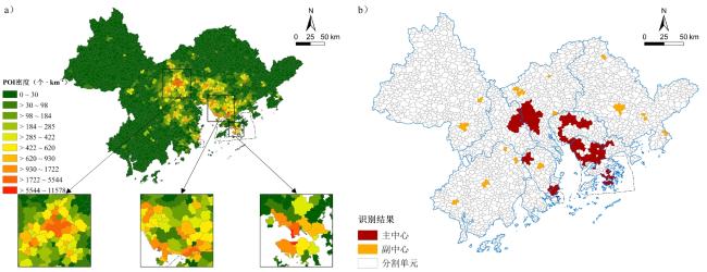
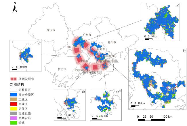
图2 粤港澳大湾区主中心与副中心分布(a. 基于珞珈一号数据划分的空间单元内POI密度;b. 粤港澳大湾区主副中心识别结果)Fig.2 The distribution of main centers and sub-centers in the Guangdong-Hong Kong-Macao Greater Bay Area (a. POI density in space units based on Luojia1-01 data; b. Identification result of the main and sub-centers in the Guangdong-Hong Kong-Macao Greater Bay Area) |
表2 粤港澳大湾区各城市与主中心空间关联等级数量统计Table 2 Level and quantity statistics of spatial correlation between cities and the main centers in the Guangdong-Hong Kong-Macao Greater Bay Area |
| 城市 | 一级联系 | 二级联系 | 三级联系 | 四级联系 | 五级联系 |
|---|---|---|---|---|---|
| 总计 | 3 | 11 | 25 | 14 | 2 |
| 广州市 | 1 | 1 | 3 | ||
| 深圳市 | 1 | 2 | 1 | 1 | |
| 香港特别行政区 | 1 | 1 | 2 | 1 | |
| 佛山市 | 2 | 3 | |||
| 东莞市 | 2 | 3 | |||
| 中山市 | 2 | 3 | |||
| 惠州市 | 1 | 2 | 2 | ||
| 珠海市 | 3 | 2 | |||
| 江门市 | 3 | 2 | |||
| 肇庆市 | 2 | 2 | 1 | ||
| 澳门特别行政区 | 4 | 1 |

1 资料来源:粤港澳大湾区门户网. http://www.cnbayarea.org.cn/.
2 http://www.hbeos.org.cn/
3 https://www.amap.com/
4 https://www.gscloud.cn/
5 https://www.worldpop.org/
植秋滢:提出研究构想,数据分析、论文撰写;
陈洁莹:数据分析与制图,论文撰写;
付迎春:提出研究构想、修改论文;
郭碧云:提供数据与研究建议,修改论文。
|
Anselin L. 1995. Local Indicators of Spatial Association-LISA. Geogr. Anal, 27: 93-115.
|
|
Cai Jixuan, Huang Bo and Song Yimeng. 2017. Using Multi-Source Geospatial Big Data to Identify the Structure of Polycentric Cities. Remote Sensing of Environment, 202: 210-221.
|
|
陈颖彪,郑子豪,吴志峰,千庆兰. 2019. 夜间灯光遥感数据应用综述和展望. 地理科学进展,38(2):205-223. [Chen Yingbiao, Zheng Zihao, Wu Zhifeng and Qian Qinglan. 2019. Review and Prospect of Application of Nighttime Light Remote Sensing Data. Progress in Geography, 38(2): 205-223. ]
|
|
Chen Zuoqi, Yu Bailang, Song Wei, Liu Hongxing, Wu Qiusheng, Shi Kaifang and Wu Jianping. 2017. A New Approach for Detecting Urban Centers and Their Spatial Structure with Nighttime Light Remote Sensing. IEEE Transactions on Geoscience and Remote Sensing, 55(11): 6305-6319.
|
|
邓昊键,李恒凯,熊永柱,郑春燕,李迎双. 2020. 近20年粤港澳大湾区城市群时空演化格局分析. 世界地理研究,29(6):1181-1189. [Deng Haojian, Li Hengkai, Xiong Yongzhu, Zheng Chunyan and Li Yingshuang. 2020. Temporal-Spatial Evolution of Urban Agglomeration in Guangdong-Hong Kong-Macao Greater Bay Area in Recent 20 Years. World Regional Studies, 29(6): 1181-1189. ]
|
|
窦旺胜,王成新,薛明月,王召汉. 2020. 基于POI数据的城市用地功能识别与评价研究——以济南市内五区为例. 世界地理研究,29(4):804-813. [Dou Wangsheng, Wang Chengxin, Xue Mingyue and Wang Zhaohan. 2020. Identification and Evaluation of Urban Functional Land Based on POI Data: A Case Study of Five Districts in Jinan. World Regional Studies, 29(4): 804-813. ]
|
|
顾朝林. 2011. 城市群研究进展与展望. 地理研究,30(5):771-784. [Gu Chaolin. 2011. Study on Urban Agglomeration: Progress and Prospect. Geographical Research, 30(5): 771-784. ]
|
|
浩飞龙. 2017. 多中心视角下的长春市城市功能空间结构研究. 长春:东北师范大学. [Hao Feilong. 2017. Spatial Structure of Urban Functions of Changchun in the Perspective of Polycentricity. Changchun: Northeast Normal University. ]
|
|
浩飞龙,王士君,冯章献,于婷婷,马丽. 2018. 基于POI数据的长春市商业空间格局及行业分布. 地理研究,37(2):366-378. [Hao Feilong, Wang Shijun, Feng Zhangxian, Yu Tingting and Ma Li. 2018. Spatial Pattern and Its Industrial Distribution of Commercial Space in Changchun Based on POI Data. Geographical Research, 37(2): 366-378. ]
|
|
黄毅. 2008. 城市混合功能建设研究. 上海:同济大学. [Huang Yi. 2008. A Study of Urban Mixed-Use Development in Theory and Practice. Shanghai: Tongji University. ]
|
|
姜佳怡,戴菲,章俊华. 2020. 基于POI数据的城市功能结构对比研究——以北京、上海为例. 现代城市研究,(7):42-50. [Jiang Jiayi, Dai Fei and Zhang Junhua. 2020. Comparative Study of Urban Functional Structure Based on POI Data: A Case Study of Beijing and Shanghai. Modern Urban Research, (7): 42-50. ]
|
|
李德仁,李熙. 2015. 论夜光遥感数据挖掘. 测绘学报,44(6):591-601. [Li Deren and Li Xi. 2015. An Overview on Data Mining of Nighttime Light Remote Sensing. Acta Geodaetica et Cartographica Sinica, 44(6): 591-601. ]
|
|
李德仁,张过,沈欣,钟兴,蒋永华,汪韬阳,涂建光,李治江. 2019. 珞珈一号01星夜光遥感设计与处理. 遥感学报,23(6):1011-1022. [Li Deren, Zhang Guo, Shen Xin, Zhong Xing, Jiang Yonghua, Wang Taoyang, Tu Jianguang and Li Zhijiang. 2019. Design and Processing Night Light Remote Sensing of LJ-1 01 Satellite. Journal of Remote Sensing, 23(6): 1011-1022. ]
|
|
Li Jiufeng, Wang Fangfang, Fu Yingchun, Guo Biyun, Zhao Yaolong and Yu Huafei. 2020. A Novel SUHI Referenced Estimation Method in Multi-Centers Urban Agglomeration with DMSP/OLS Nighttime Light Data. IEEE Journal of Selected Topics in Applied Earth Observations and Remote Sensing, 13: 1416-1425.
|
|
Li Miaoyi, Shen Zhenjiang and Hao Xinhua. 2016. Revealing the Relationship between Spatio-Temporal Distribution of Population and Urban Function with Social Media Data. GeoJournal, 81(6): 919-935.
|
|
李翔. 2018. 基于夜光遥感数据的中国2005-2015年居民收入时空变化与驱动力研究. 南京:南京大学. [Li Xiang. 2018. Study on Spatiotemporal Change and Driving Force of Resident Income of China from 2005 to 2015 Based on Night Light Remote Sensing Data. Nanjing: Nanjing University. ]
|
|
刘权毅,詹庆明,李建松,杨晨,刘稳. 2021. 珞珈一号夜间灯光影像在建设用地提取中的应用:以武汉市为例. 武汉大学学报(信息科学版),46(1):30-39. [Liu Quanyi, Zhan Qingming, Li Jiansong, Yang Chen and Liu Wen. 2021. Extracting Built-up Areas Using Luojia 1-01 Nighttime Light Imageries in Wuhan, China. Geomatics and Information Science of Wuhan University, 46(1): 30-39. ]
|
|
Liu Yangxiaoyue, Yang Yaping, Jing Wenlong, Yao Ling, Yue Xiafang and Zhao Xiaodan. 2017. A New Urban Index for Expressing Inner-City Patterns Based on MODIS LST and EVI Regulated DMSP/OLS NTL. Remote Sensing, 9(8): 777.
|
|
Lou Ge, Chen Qiuxiao, He Kang, Zhou Yue and Shi Zhou. 2019. Using Nighttime Light Data and POI Big Data to Detect the Urban Centers of Hangzhou. Remote Sensing, 11(15): 1821.
|
|
罗洁斯,万昆. 2018. 普通中小学空间预警系统研究——武汉市普通中小学布局规划的实施探索. 现代城市研究,(5):18-23. [Luo Jiesi and Wan Kun. 2018. Study on Space Alert System for Nine-Year Compulsory Education School. Modern Urban Research, (5): 18-23. ]
|
|
罗庆,李小建. 2019. 基于VIIRS夜间灯光的中国城市中心的分异特征及其影响因素. 地理研究,38(1):155-166. [Luo Qing and Li Xiaojian. 2019. The Spatial Differentiation and Influencing Factors of Urban Centers in China Based on VIIRS Night Light. Geographical Research, 38(1): 155-166. ]
|
|
毛帅永,焦利民,许刚,李泽慧. 2019. 基于多源数据的武汉市多中心空间结构识别. 地理科学进展,38(11):1675-1683. [Mao Shuaiyong, Jiao Limin, Xu Gang and Li Zehui. 2019. Identification of the Polycentric Spatial Structure in Wuhan City Based on Multisource Data. Progress in Geography, 38(11): 1675-1683. ]
|
|
彭芳梅. 2017. 粤港澳大湾区及周边城市经济空间联系与空间结构——基于改进引力模型与社会网络分析的实证分析. 经济地理,37(12):57-64. [Peng Fangmei. 2017. Economic Spatial Connection and Spatial Structure of Guangdong-Hong Kong-Macao Greater Bay and the Surrounding Area Cities—An Empirical Analysis Based on Improved Gravity Model and Social Network Analysis. Economic Geography, 37(12): 57-64. ]
|
|
邱坚坚,刘毅华,陈浩然,高枫. 2019. 流空间视角下的粤港澳大湾区空间网络格局——基于信息流与交通流的对比分析. 经济地理,39(6):7-15. [Qiu Jianjian, Liu Yihua, Chen Haoran and Gao Feng. 2019. Urban Network Structure of Guangdong-Hong Kong-Macao Greater Bay Area with the View of Space of Flows: A Comparison between Information Flow and Transportation Flow. Economic Geography, 39(6): 7-15. ]
|
|
Scott A J. 2002. Global City-Regions. Trends, Theory, Policy. Progress in Human Geography, 26(5): 712-713.
|
|
苏泳娴,陈修治,叶玉瑶,吴旗韬,张虹鸥,黄宁生,匡耀求. 2013. 基于夜间灯光数据的中国能源消费碳排放特征及机理. 地理学报,68(11):1513-1526. [Su Yongxian, Chen Xiuzhi, Ye Yuyao, Wu Qitao, Zhang Hong'ou, Huang Ningsheng and Kuang Yaoqiu. 2013. The Characteristics and Mechanisms of Carbon Emissions from Energy Consumption in China Using DMSP/OLS Night Light Imageries. Acta Geographica Sinica, 68(11): 1513-1526. ]
|
|
王成港,宁晓刚,王浩,刘效江. 2019. 利用夜间灯光数据的城市群格局变化分析. 测绘科学,44(6):176-186. [Wang Chenggang, Ning Xiaogang, Wang Hao and Liu Xiaojiang. 2019. Spatial Pattern Change of China Urban Agglomerations Using Nighttime Light Data. Science of Surveying and Mapping, 44(6): 176-186. ]
|
|
王利伟,冯长春. 2016. 转型期京津冀城市群空间扩展格局及其动力机制——基于夜间灯光数据方法. 地理学报,71(12):2155-2169. [Wang Liwei and Feng Changchun. 2016. Spatial Expansion Pattern and Its Driving Dynamics of Beijing-Tianjin-Hebei Metropolitan Region: Based on Nighttime Light Data. Acta Geographica Sinica, 71(12): 2155-2169. ]
|
|
王美玲,张和生. 2021. 基于珞珈一号夜间灯光数据的人口空间化研究. 地理空间信息,19(9):53-56,7. [Wang Meiling and Zhang Hesheng. 2021. Research on Population Spatialization Based on Luojia-1 Nighttime Light Data. Geospatial Information, 19(9): 53-56, 7 ]
|
|
吴冠秋,党安荣,田颖,阚长城. 2021. 基于时空大数据的粤港澳大湾区城镇群结构研究. 遥感学报,25(2):665-676. [Wu Guanqiu, Dang Anrong, Tian Ying and Kan Changcheng. 2021. Study on the Urban Agglomerations Structure of the Guangdong-Hong Kong-Macao Greater Bay Area Based on Spatiotemporal Big Data. National Remote Sensing Bulletin, 25(2): 665-676. ]
|
|
许泽宁,高晓路. 2016. 基于电子地图兴趣点的城市建成区边界识别方法. 地理学报,71(6):928-939. [Xu Zening and Gao Xiaolu. 2016. A Novel Method for Identifying the Boundary of Urban Built-up Areas with POI Data. Acta Geographica Sinica, 71(6): 928-939. ]
|
|
于丙辰,刘玉轩,陈刚. 2018. 基于夜光遥感与POI数据空间耦合关系的南海港口城市空间结构研究. 地球信息科学学报,20(6):854-861. [Yu Bingchen, Liu Yuxuan and Chen Gang. 2018. Urban Spatial Structure of Port City in South China Sea Based on Spatial Coupling between Nighttime Light Data and POI. Journal of Geo-Information Science, 20(6): 854-861. ]
|
|
张亮,岳文泽,刘勇. 2017. 多中心城市空间结构的多维识别研究——以杭州为例. 经济地理,37(6):67-75. [Zhang Liang, Yue Wenze and Liu Yong. 2017. Multidimensional Analysis of the Polycentric Urban Spatial Structure—A Case of Hangzhou. Economic Geography, 37(6): 67-75. ]
|
|
赵渺希. 2011. 长三角区域的网络交互作用与空间结构演化. 地理研究,30(2):311-323. [Zhao Miaoxi. 2011. Evolution of Network and Spatial Structure in Yangtze River Delta. Geographical Research, 30(2): 311-323. ]
|
|
钟亮,刘小生. 2019. 珞珈一号新型夜间灯光数据应用潜力分析. 测绘通报,(7):132-137. [Zhong Liang and Liu Xiaosheng. 2019. Application Potential Analysis of LJ1-01 New Nighttime Light Data. Bulletin of Surveying and Mapping, (7): 132-137. ]
|
|
周春山,罗利佳,史晨怡,王珏晗. 2017. 粤港澳大湾区经济发展时空演变特征及其影响因素. 热带地理,37(6):802-813. [Zhou Chunshan, Luo Lijia, Shi Chenyi and Wang Juehan. 2017. Spatio-Temporal Evolutionary Characteristics of the Economic Development in the Guangdong-Hong Kong-Macao Greater Bay Area and Its Influencing Factors. Tropical Geography, 37(6): 802-813. ]
|
/
| 〈 |
|
〉 |