
Intelligent Planning of Village Roads for Rural Revitalization: A Case Study of Gangtou Village, Huadu District, Guangzhou
Received date: 2022-10-14
Revised date: 2023-01-20
Online published: 2023-02-28
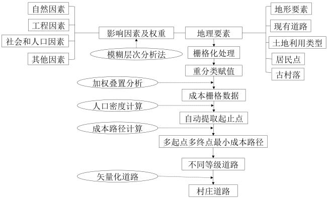
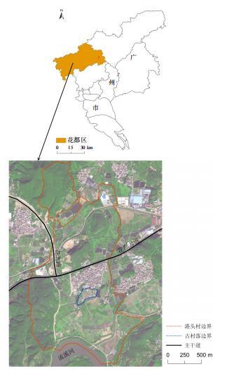
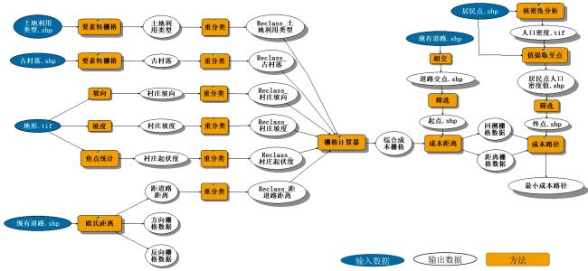
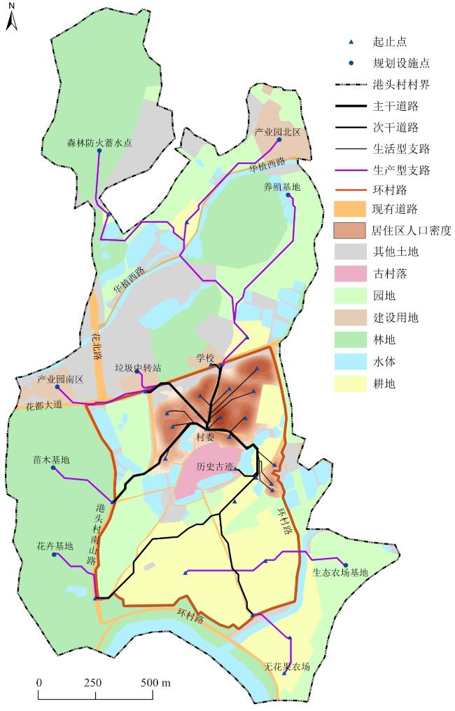
A rural revitalization strategy has been proposed, and more attention has been paid to village planning, which has become an important measure to adjust to local conditions, implement policies accurately, and build a beautiful countryside. The core of rural revitalization involves planning first, promoting industry, serving the countryside, and planning the village as the unit. An important aspect of village planning is road planning and design, which is essential to further connect agricultural production, country living, and ecological space of the village; promote production; serve life; and strengthen traffic between the village and the external region. Owing to the differences in geographical and natural conditions and the level of economic development between urban and rural areas in China, village road planning cannot copy the previous methods of road route selection and urban road planning. Instead, it is necessary to explore a universal, efficient, and intelligent village road planning method that considers the actual situation of rural development by considering agricultural production, villagers' lives, industrial development, historical and cultural protection, and other factors. In the context of rural revitalization, this study takes the village as the planning unit, considers the natural environment, current layout, and development needs of the village, uses the qualitative and quantitative fuzzy analytic hierarchy process to analyze and quantify the natural, social, demographic and other factors of the village road planning and their weights, and uses the weighted superposition analysis method to form a comprehensive cost grid of the village with multiple elements. A process-based village road planning GIS tool is constructed, and the minimum cost path algorithm was used to automatically generate the village road network with the minimum comprehensive cost. Taking Gangtou Village in Huadu District of Guangzhou City as an example, the feasibility of the above methods, technical processes, and GIS tools was verified, and a village-wide comprehensive cost grid was efficiently generated. According to the five elements of residential areas, cultivated land, historical monuments, public facilities, and entrances and exits of external roads, five categories, seven starting points, and 16 ending points of village planning roads were automatically extracted, and a four-level village road from multiple starting points to multiple ending points was automatically generated, including four main roads with a width of 5-8 meters, two secondary main roads with a width of 3-5 meters, nine productive branch roads with a width of 2-3 meters, 13 living branch roads, and one village road. The results show that the village road planning method proposed here can efficiently generate multi-type and multi-level village roads, and the planned road network not only has a minimum construction cost but also good connectivity and practicability. The village road-planning method proposed in this study integrates natural, social, demographic, and industrial development factors and their characteristics, providing systematic ideas and automated methods for village road planning. This is helpful for promoting the intelligence of village road planning.
Yina Liu , Shitai Bao , Meixuan She , Shunqing Chen . Intelligent Planning of Village Roads for Rural Revitalization: A Case Study of Gangtou Village, Huadu District, Guangzhou[J]. Tropical Geography, 2023 , 43(2) : 226 -233 . DOI: 10.13284/j.cnki.rddl.003625
表1 港头村道路规划影响要素成本赋值Table 1 Classification scores of road planning in Gangtou Village |
| 影响因子 | 数据类别/范围 | 成本值 | 数据类别/范围 | 成本值 |
|---|---|---|---|---|
| 土地利用 | 水体 | 128 | 建设用地 | 64 |
| 耕地 | 32 | 园地 | 16 | |
| 林地 | 8 | 其他土地 | 4 | |
| 交通用地 | 2 | — | — | |
| 坡度/(º) | 69~80 | 128 | 57~69 | 64 |
| 46~57 | 32 | 34~46 | 16 | |
| 23~34 | 8 | 11~23 | 4 | |
| 0~11 | 2 | — | — | |
| 坡向/(º) | 308~360 | 128 | 256~308 | 64 |
| 205~256 | 32 | 153~205 | 16 | |
| 102~153 | 8 | 50~102 | 4 | |
| -1~50 | 2 | — | — | |
| 起伏度/(º) | 240~275 | 128 | 205~240 | 64 |
| 170~205 | 32 | 134~170 | 16 | |
| 99~134 | 8 | 64~99 | 4 | |
| 29~64 | 2 | — | — | |
| 距道路距离/m | 1 077~1 256 | 128 | 897~1 077 | 64 |
| 717~897 | 32 | 538~717 | 16 | |
| 359~538 | 8 | 179~359 | 4 | |
| 0~179 | 2 | — | — | |
| 历史古迹 | 古村落 | 128 | — | — |
表2 港头村道路规划影响因子矩阵及权重Table 2 Influence factor matrix and weight of road planning in Gangtou Village |
| 因素 | 土地利用类型 | 坡度 | 坡向 | 起伏度 | 古村落 | 距道路距离 | 权重 |
|---|---|---|---|---|---|---|---|
| 土地利用类型 | 0.500 | 0.400 | 0.400 | 0.400 | 0.283 | 0.200 | 0.113 |
| 坡度 | 0.600 | 0.500 | 0.499 | 0.499 | 0.400 | 0.300 | 0.153 |
| 坡向 | 0.600 | 0.501 | 0.500 | 0.499 | 0.400 | 0.300 | 0.153 |
| 起伏度 | 0.600 | 0.501 | 0.501 | 0.500 | 0.400 | 0.300 | 0.153 |
| 古村落 | 0.700 | 0.600 | 0.600 | 0.600 | 0.500 | 0.400 | 0.194 |
| 距道路距离 | 0.800 | 0.700 | 0.700 | 0.700 | 0.600 | 0.500 | 0.234 |
表3 村庄规划道路的起点和终点自动提取参数Table 3 Automatic extraction parameters of starting point and ending point of village planning road |
| 要素 | 起点 | 终点 | 提取参数 | 连接道路类型 |
|---|---|---|---|---|
| 土地利用—居住区 | √ | 提取居住区内人口密度最高值点 | 生活型支路 | |
| 土地利用—耕地 | √ | 取耕地面的中心点 | 生产型支路 | |
| 历史古迹—古村落 | √ | 取古建筑点 | 次干道路 | |
| 公共设施 | √ | √ | 全部提取,含学校、村委等 | 次干道路 |
| 对外道路出入口 | √ | √ | 全部提取 | 主干道路 |

刘以娜:确定研究总体思路,收集、处理与分析数据,撰写初稿及修改论文;
包世泰:提供研究选题与思路,规划论文框架,指导论文写作与修改;
佘美萱:提供规划案例,指导论文写作;
陈顺清:提供村镇规划思路,参与论文修改。
|
白雁,万传风,魏庆朝,丁海波. 2005. 农村公路网布局规划方法研究. 北京交通大学学报,29(4):33-36.
Bai Yan, Wan Chuanfeng, Wei Qingchao, and Ding Haibo. 2005. Study on the Layout Planning Method of Rural Highway Network. Journal of Beijing Jiaotong University, 29(4): 33-36.
|
|
陈元涛. 2012. 基于GIS的道路智能化选线方法研究. 重庆:重庆交通大学.
Chen Yuantao. 2012. Research on Intelligent Road Route Selection Method Based on GIS. Chongqing: Chongqing Jiaotong University
|
|
成永刚. 2017. 广州市以旅游产业为导向的传统村落的规划发展研究. 广州:华南农业大学.
Cheng Yonggang. 2017. Research on the Planning and Development of Traditional Villages Guided by Tourism Industry in Guangzhou. Guangzhou: South China Agricultural University.
|
|
方健,杨兴柱,朱琳. 2017. 黄山市乡村聚落空间格局特征及其影响因素. 热带地理,37(2):277-285,292.
Fang Jian, Yang Xingzhu, and Zhu lin. 2017. Spatial Pattern Characteristics and Influencing Factors of Rural Settlements in Huangshan City. Tropical Geography, 37 (2): 277-285, 292.
|
|
Galin E, Peytavie A, Maréchal N, and Guérin E. 2010. Procedural Generation of Roads. Computer Graphics Forum, 29(2): 429-438.
|
|
高红江,刘应宗,潘珍妮. 2012. 农村公路规划研究进展. 中外公路,32(2):281-285.
Gao Hongjiang, Liu Yingzong, and Pan Jeanne. 2012. Research Progress of Rural Highway Planning. Zhongwai Highway, 32 (2): 281-285.
|
|
Howe John, and Richards Peter. 1984. Rural Roads and Poverty Alleviation. London: ITDG.
|
|
何耀. 2014. 城乡结合区域农村路网规划研究. 重庆:重庆交通大学.
He Yao. 2014. Research on Rural Road Network Planning in Urban-Rural Areas. Chongqing: Chongqing Jiaotong University.
|
|
黄德军. 2019. 城市道路规划设计发展趋势探讨. 中华建设,179(6):94-95.
Huang Dejun. 2019. Discussion on the Development Trend of Urban Road Planning and Design. China Construction, 179 (6): 94-95.
|
|
Inti Sundeep, and Kumar Siddagangaiah Anjan. 2021. Sustainable Road Design through Multi-Objective Optimization: A Case Study in Northeast India. Amsterdam: ELSEVIER.
|
|
Kadi Fatih, Yildirim Faruk, and Saralioglu Ekrem. 2019. Risk Analysis of Forest Roads Using Landslide Susceptibility Maps and Generation of the Optimum Forest Road Route: A Case Study in Macka, Turkey. Geocarto International, 36(14): 1612-1629.
|
|
刘语轩,任利剑,运迎霞. 2019. 美丽乡村背景下村庄道路规划设计浅析//中国城市规划学会城市交通规划学术委员会. 品质交通与协同共治——2019年中国城市交通规划年会论文集. 成都:中国城市规划设计研究院城市交通专业研究院,1189-1196.
Liu Yuxuan, Ren Lijian, and Yun Yingxia. 2019. Analysis of Village Road Planning and Design in the Context of Beautiful Countryside. In: Urban Transport Planning Academic Committee of China Urban Planning Society. Quality Transportation and Collaborative Governance -Proceedings of the 2019 China Urban Transportation Planning Annual Conference. Chengdu: China Academy of Urban Planning and Design Institute of Urban Transport, 1189-1196.
|
|
栾翠霞. 2017. 关注乡村居民出行方式的乡村道路规划设计研究. 昆明:昆明理工大学.
Luan Cuixia. 2017. Research on the Planning and Design of Rural Roads that Pay Attention to the Travel Modes of Rural Residents. Kunming: Kunming University of Technology.
|
|
Maribeth P. 2015. Mastering ArcGIS. New York: McGraw-Hill College.
|
|
Meng Qiang. 2000. Bi-Level Transportation Modeling and Optimization. Hongkong: Hong Kong University of Science and Technology.
|
|
史涵,葛莹,鲍倩,刘磊. 2019. 基于GIS成本路径的智能道路规划. 甘肃科学学报,31(4):30-34.
Shi Han, Ge Ying, Bao Qian, and Liu Lei. 2019. Intelligent Road Planning Based on GIS Cost Path. Gansu Journal of Science, 31 (4): 30-34.
|
|
苏木兰,戴文远,黄华富,郭强,黄剑彬. 2016. 快速城镇化背景下海岛农村居民点空间演变——以福建海坛岛为例. 热带地理,36(6):1005-1018.
Su Mulan, Dai Wenyuan, Huang Huafu, Guo Qiang, and Huang Jianbin. 2016. Spatial Evolution of Rural Settlements on Islands under the Background of Rapid Urbanization: A Case Study of Haitan Island, Fujian. Tropical Geography, 36 (6): 1005-1018.
|
|
王凯. 2016. 农村公路网的规划方法与应用研究. 深圳:深圳大学.
Wang Kai. 2016. Research on the Planning Method and Application of Rural Road Network. Shenzhen: Shenzhen University.
|
|
王冉然. 2010. 基于GIS的新农村道路选线研究. 湘潭:湖南科技大学.
Wang Ranran. 2010. Research on Route Selection of New Rural Roads Based on GIS. Xiangtan: Hunan University of Science and Technology.
|
|
王永慧,张景岩. 2021. 农村道路和绿化建设存在的问题及对策. 现代农业科技,783(1):176-177.
Wang Yonghui, and Zhang Jingyan. 2021. Problems and Countermeasures in Rural Road and Greening Construction. Modern Agricultural Science and Technology, 783(1): 176-177.
|
|
叶瑞云,周玉松,衷平. 2021. 基于乡村振兴发展的旅游公路规划选线研究. 公路,66(12):257-260.
Ye Ruiyun, Zhou Yusong, and Zhong Ping. 2021. Research on the Planning and Route Selection of Tourism Roads Based on Rural Revitalization and Development. Highway, 66 (12): 257-260.
|
|
岳萍,岳成梦. 2016. 新农村公路网规划布局的影响因素及方法研究. 江西建材,191(14):144,147.
Yue Ping, and Yue Chengmeng. 2016. Research on Influencing Factors and Methods of Planning and Layout of New Rural Highway Network. Jiangxi Building Materials, 191(14): 144, 147.
|
|
郑培松. 2020. 高速公路路线方案综合研究. 工程技术研究,5(24):168-169. DOI:10.19537/j.cnki.2096-2789.2020.24.078.
Zheng Peisong. 2020. Comprehensive Study of Expressway Route Scheme. Engineering Technology Research, 5(24): 168-169. DOI: 10.19537/j.cnki.2096-2789.2020.24.078.
|
|
中华人民共和国住房和城乡建设部. 2017. 乡村道路工程技术规范(GB/T 51224-2017). (2017-02-21)[2022-12-15]. https://www.nssi.org.cn/cssn/js/pdfjs/web/preview.jsp?a100=GB/T%2051224-2017.
Ministry of Housing and Urban-Rural Development of the People's Republic of China. 2017. Technical Specifications for Rural Road Engineering. (GB/T 51224-2017) (2017-02-21) [2022-12-15]. https://www.nssi.org.cn/cssn/js/pdfjs/web/preview.jsp?a100=GB/T%2051224-2017.
|
/
| 〈 |
|
〉 |