
Tacit Knowledge on Maps: A Discussion Centered on the Location of the Wailuo on the Zhongguo gu hang hai tu in the Beinecke Library
Received date: 2023-02-16
Revised date: 2023-03-03
Online published: 2023-06-13
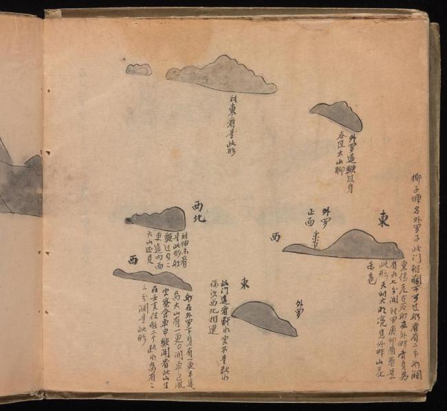
The Beinecke Library of Yale University owns an ancient Chinese sea atlas, Zhongguo gu hang hai tu, which has attracted considerable scholarly interest over the last three decades. In 2018, Wing-Sheung Cheng published his research monograph focusing on this atlas. However, his identification of certain geographical features is problematic; in particular, the Wailuo (外罗), depicted several times in the pages of the Zhongguo gu hang hai tu, is identified as either Robert Island or Money Island in the Paracel Islands. Based on comparison with other sources, which invariably place the Wailuo near the coast of modern Vietnam (Cù Lao Ré), it is concluded that Cheng misread the cartographic representations of the atlas. In order to better elucidate the causes of this misreading, this paper introduces the epistemological concept of "tacit knowledge," coined by the philosopher Michael Polanyi (1891-1976), into the study on the history of cartography. Tacit knowledge as a notion has developed different meanings since Polanyi, and is construed as the opposite of explicit knowledge. Matthew H. Edney has championed the investigation of the mapping process rather than simply the mapping practice in the history of cartography. It is argued that the mapping process of ancient nautical charts involved tacit knowledge, which was not fully inscribed into or depicted on the charts. Acknowledging and revitalizing such tacit knowledge is of paramount importance to the study of the history of cartography. Because modern and scientific cartography has transcended and obfuscated the mapping process of ancient sea charts, tacit knowledge is sometimes ignored or misinterpreted, which eventually results in ancient maps and charts becoming seemingly unintelligible. Therefore, the underlying cause for Cheng's misreading of the Wailuo can be attributed to his over-reliance on the explicit knowledge drawn on the pages of the atlas, and ignorance of the rich tacit knowledge that was passed down through generations of Chinese seafarers, until it was overtaken by modern sea charts. This case study also echoes recent debates regarding the progress and setbacks in the history of cartographic studies in China. It shows that theoretical exploration is capable of facilitating the improvement and long-term viability of the history of cartography in the Chinese language world.
Yannan Ding . Tacit Knowledge on Maps: A Discussion Centered on the Location of the Wailuo on the Zhongguo gu hang hai tu in the Beinecke Library[J]. Tropical Geography, 2023 , 43(5) : 783 -794 . DOI: 10.13284/j.cnki.rddl.003647

1 引文中的加粗字体系原文所有。
2 匿名. 中国古航海图. 耶鲁大学贝尼克图书馆,https://collections.library.yale.edu/catalog/16563284,下载日期:2021-05-07。
3 关于它的再发现、传播和研讨的历史,前引文献中已有介绍,兹不赘述。该图本无图名,学者们各有不同的命名方式。本文依据收藏机构称之为《中国古航海图》。
4 “默会知识”,或译作“隐性知识”“意会理论”“意会知识”“缄默知识”等。1958年,迈克尔·波兰尼于北斯塔福德郡大学学院(今英国基尔大学,Keele University)在“林塞纪念讲座”中提出这一概念,其讲稿次年出版(Polanyi, 1959);另见文献Gascoigne等(2013)。笔者依据的是郁振华(2012)46的译法。
5 中文世界对迈克尔·波兰尼的翻译和引介始自上世纪80年代,本世纪以来愈加丰富(迈可•博蓝尼,1985;迈克尔·波兰尼,2000;2004;2006;2017a;2017b)。
6 这句话的原文是“our knowledge may include far more than we can tell”(Polanyi, 1961)467。
7 关于knowing how与knowing that之间的联系与区别,参见郁振华(2012)69-102。
8 此处“实证式的”指以文本考订和图像描述为特征的地图学史研究方法,它认定地图就是地理事实的陈述(maps are statements of geographical fact)。它同理论之间存在一种表层上的紧张乃至互斥的关系,参见文献Edney(1996)。
9 将地图学视作过程的学者还有罗伯·基钦(Rob Kitchin)等人,参见文献Kitchin等(2007;2013)。
10 页序依据贝尼克图书馆将该图集电子化后给定的图幅序号(不含地图册封面、扉页,等)。
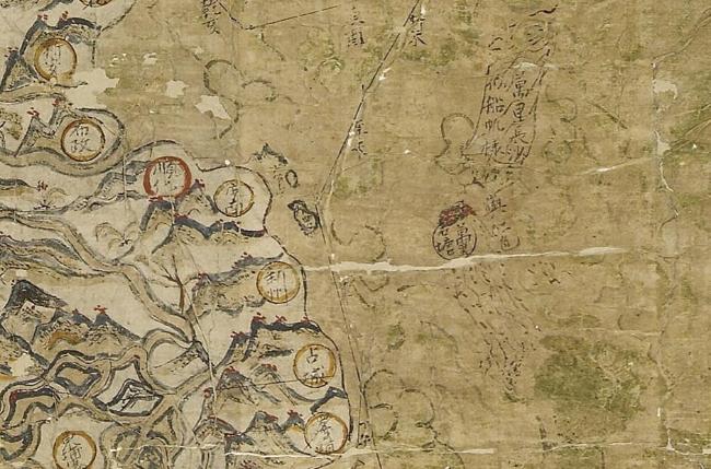
11 李山岛(Đảo Lý Sơn),即惹岛(Cù Lao Ré)。又作理山岛,郑永常书中作李仙岛。位于今越南中部广义省(Quảng Ngãi)海域,距离海岸约28 km。紧邻李山岛有一个更小的伯拜岛(Cù lao Bờ Bãi),在有的古地图上二者构成“广东群岛”(P. Canton及其变体)。两岛总面积约10.39 km2。
12 冗字“在”系郑著原文所有,“八更”或系抄录“七更”时的笔误。
13 即贝尼克图书馆序号第5r图。值得注意的是,这个自南向北的相对方位与自北向南的完美互补,见第7r图上的文字标记,“外罗一更外开,用丙午取跤杯外过。”
14 在古代罗盘上,“单子及子癸”,即朝向正北方或北略偏东方。钱江等(2013)7认为,校柸是“越南归仁港东面Phuong Mai一带的海角”。笔者认为或为归仁港外东北方近海小岛。无论是哪种情况,均位于李山岛的南方,因而需朝北航行至外罗。
15 此处以“常规南海航线”指称常用的、广为人知的商贸航线,以区别于偶发航线,例如,在遭遇台风、捕鱼、打捞沉船货物等情况下实际采用的航线。
16 也称《塞尔登中国地图》或《雪尔登中国地图》。牛津大学图书馆称之为The Selden Map of China。
17 该《更路簿》抄写时间在1930年前后。
18 其绘制和使用方式类似于西方近代航海中发展出来的对景图(front view)或海岸轮廓图(coastal profile)。赖进义(2017)173称之为“景观定位法”,“以行船者站在船头观测有关景物时产生的视觉感受而绘制,山形、地物以写景法表示”。
19 此外,他还写道:“经纬度的测验是以Google GPS来进行,由于一些地名位于沿海或海岛上,GPS测定时会稍微移位,故经纬度并不是完全准确,但在可接受的范围内,这样古今地名便可贯通起来,使古代针路能在现代的地图上画出航线来。”参见(郑永常,2018)49。台湾“中研院”网页所登载的郑永常治学访谈中也可见有关研究方法的介绍,http://mingching.sinica.edu.tw/Academic_Detail/868,2020-10-16。
20 这张图(第7v图)上还绘制了两个“尖笔罗”。尖笔罗同外罗之间的相对位置,并不反映这两组岛屿在现实中的方位。
21 伦敦文物学会(Society of Antiquaries of London,SAL),https://www.sal.org.uk/collections/explore-our-collections/collections-highlights/maritime-direction-book/,2021-06-03.
22 包括:Edney(1996)、Jacob(1996)、Delano-Smith(1996)等3篇论文,以及由Ed Dahl撰写的引言和一组共有5人参加的讨论。
23 原文为:“complex assessments of the development of cartographic genres and processes within and between societies”。
24 原文为英文:“Since the war of 1840-1843, the intercourse of the Chinese with the English has led them to perceive the intricate superiority of English charts, which are now eagerly sought for by many masters of Chinese vessels. Hence native charts, like those in this book, are falling into disuse, & may soon be curiosities.”。
|
安可斯密特F R. 2011. 历史表现. 周建漳,译. 北京:北京大学出版社.
Franklin Rudolf. Ankersmit. 2011. Historical Representation. Zhou Jianzhang. Trans.. Beijing: Peking University Press.
|
|
Bennett J. 2017. Navigation, A Very Short Introduction. Oxford: Oxford University Press.
|
|
成一农. 2014. “科学”还是“非科学”——被误读的中国传统舆图. 厦门大学学报(哲学社会科学版),(2):20-27.
Cheng Yinong. 2014. "Science" or "Non-science": the Misunderstood Chinese Traditional Maps. Journal of Xiamen University (Arts & Social Sciences), (2): 20-27.
|
|
成一农. 2016. “非科学”的中国传统舆图:中国传统舆图绘制研究. 北京:中国社会科学出版社.
Cheng Yinong. 2016. The Study on the Cartographic Method of the Chinese Ancient Maps. Beijing: China Social Sciences Press.
|
|
成一农. 2019a. 近70年来中国古地图与地图学史研究的主要进展. 中国历史地理论丛,(3):18-34.
Cheng Yinong. 2019a. Major Progress in the Study of Chinese Ancient Maps and Cartography History in the Past 70 Years and Prospects for the Future. Journal of Chinese Historical Geography, (3): 18-34.
|
|
成一农. 2019b. 中国古代地图学史中“制图六体”经典地位的塑造——史学研究中分析“历史认知”形成过程的重要性. 思想战线,(3):125-132.
Cheng Yinong. 2019b. Construction of the Classical Status of "Zhitu Liuti" in the History of Ancient Chinese Cartography: On the Importance of Analyzing the Formation of "Historical Cognition" in the Study of History. Thinking, (3): 125-132.
|
|
成一农. 2019c. 经典的塑造与历史的书写——以《广舆图》为例. 苏州大学学报(哲学社会科学版),(4):174-183.
Cheng Yinong. 2019c. The Shaping of Classics and the Writing of History: A Case Study with the Guangyutu Atlas (Enlarged Territorial Atlas). Journal of Soochow University(Philosophy & Social Science Edition), (4): 174-183.
|
|
丁一. 2011. 耶鲁藏清代航海图北洋部分考释及其航线研究. 历史地理,(25):431-455.
Ding Yi. 2011. A Study of a Yale Collected Chart of Beiyang Compiled in the Qing Dynasty and Related Sea Routes. Historical Geography, (25): 431-455.
|
|
Edney M H. 1996. Theory and the History of Cartography. Imago Mundi, 48: 185-191.
|
|
Edney M H. 2014. Academic Cartography, Internal Map History, and the Critical Study of Mapping Processes. Imago Mundi, 66(S): 83-106.
|
|
Edney M H. 2019. Cartography: The Ideal and Its History. Chicago: The University of Chicago Press.
|
|
Gascoigne N and Thornton T. 2013. Tacit Knowledge. Durham&Bristol: Acumen.
|
|
Harley J B and Woodward D. 1989. Why Cartography Needs Its History. The American Cartographer, 16(1): 5-15.
|
|
韩昭庆,杨霄,刘敏,何国璠. 2021. 康熙《皇舆全览图》长城以南地区绘制精度的空间分异. 清华大学学报(哲学社会科学版),(3):25-33.
Han Zhaoqing, Yang Xiao, Liu Min, and He Guofan. 2021. Spatial Variation of Mapping Accuracy of the Area South of the Great Wall Depicted on Overview Maps of Imperial Territories in the Kangxi Reign. Journal of Tsinghua University (Philosophy and Social Sciences), (3): 25-33.
|
|
Jacob C. 1996. Toward a Cultural History of Cartography. Imago Mundi, 48: 191-198.
|
|
Jardine M. 2011 Sight, Sound, and Knowledge: Michael Polanyi's Epistemology as an Attempt to Redress the Sensory Imbalance in Modern Western Thought. Bulletin of Science, Technology & Society, 31(3): 160-171.
|
|
Kitchin R and Dodge M. 2007. Rethinking Maps. Progress in Human Geography, 31(3): 331-344.
|
|
Kitchin R, Gleeson J and Dodge M. 2013. Unfolding Mapping Practices: A New Epistemology for Cartography. Transactions of the Institute of British Geographers, 38(3): 480-496.
|
|
赖进义. 2017. 郑和航海图解读. 中华科技史学会学刊(台湾),(22):173-176.
Lai Chin-Yi. 2017. Interpreting the ChengHo Nautical Charts. Bulletin of Association for the History of Science, (22): 173-176.
|
|
李彩霞. 2019. 《顺风相送》南海存疑地名及针路考. 海交史研究,(2):68-79.
Li Caixia. 2019. A Study of the Dubious Toponyms and Routes in the South Sea in Shun Feng Xiang Song. Journal of Maritime History Studies, (2): 68-79.
|
|
李孝聪. 2019. 中外古地图与海上丝绸之路. 思想战线,(3):110-124.
Li Xiaocong. 2019. Chinese and Foreign Ancient Maps and Maritime "Silk Road". Thinking, (3): 110-124.
|
|
林宏. 2021. 《广舆记》与卫匡国《中国新图志》城址经纬度推定过程研究. 历史地理研究,(1):117-140.
Lin Hong. 2021. Reconstruct Martino Martini's Process of Reckoning the Coordinates in the Provincial Maps of the Working Edition of Guang Yu Ji. The Chinese Historical Geography, (1): 117-140.
|
|
刘义杰. 2014. 《耶鲁藏中国山形水势图》初解. 海洋史研究,(2):18-32.
Liu Yijie. 2014. Tentative Research on China's Appearance of Mountainous Region and the Flow of Water Chart in the Collection of Yale University. Studies of Maritime History, (2): 18-32.
|
|
刘义杰. 2015. 山形水势图说. 国家航海,(1):88-111.
Liu Yijie. 2015. Research on the Shanxing shuishi tu. National Maritime Research,(1): 88-111.
|
|
刘义杰. 2020a. 南海海道再探. 南海学刊,(1):31-46.
Liu Yijie. 2020a. Further Study on the Sea Routes in the South China Sea. The Journal of South China Sea Studies, (1): 31-46.
|
|
刘义杰. 2020b. 南海海道三探. 南海学刊,(3):56-67.
Liu Yijie. 2020b. Exploration of the Sea Route in South China Sea for the Third Time. The Journal of South China Sea Studies, (3): 56-67.
|
|
迈可•博蓝尼. 1985. 博蓝尼讲演集. 彭淮栋,译. 台北:台北联经出版.
Michael Polanyi. 1985. Collected Speeches of Michael Polanyi. Peng Huaidong. Trans. Taipei: Linking Publishing Co., Ltd.
|
|
迈克尔·波兰尼. 2000. 个人知识. 许泽民,译. 贵阳:贵州人民出版社.
Michael Polanyi. 2000. Personal Knowledge: Towards a Post-Critical Philosophy. Xu Zemin. Trans. Guiyang: Guizhou People's Publishing House.
|
|
迈克尔·波兰尼. 2004. 科学、信仰与社会. 王靖华,译. 南京:南京大学出版社. [Michael Polanyi. 2004. Science, Faith and Society. Wang Jinghua. Trans.. Nanjing: Nanjing University Press.]
|
|
迈克尔·波兰尼. 2006. 社会、经济和哲学:波兰尼文选. 彭锋,贺立平,徐陶,尹树广,译. 北京:商务印书馆.
Michael Polanyi. 2006. Society, Economics, and Philosophy, Selected Papers. Peng Feng, He Liping, Xu Tao, Yin Shuguang. Trans.. Beijing: The Commercial Press.
|
|
迈克尔·波兰尼. 2017a. 认知与存在:迈克尔·波兰尼文集. 李白鹤,译. 南京:南京大学出版社.
Michael Polanyi. 2017a. Knowing and Being, Essays by Michael Polanyi. Marjorie Grene. Edit. Li Baihe. Trans.. Nanjing: Nanjing University Press.
|
|
迈克尔·波兰尼. 2017b 个人知识. 徐陶,译. 上海:上海人民出版社.
Michael Polanyi. 2017b. Personal Knowledge: Towards a Post-Critical Philosophy. Xu Tao. Trans.. Shanghai: Shanghai People's Publishing House.
|
|
Polanyi M. 1959. The Study of Man. Chicago: The University of Chicago Press.
|
|
Polanyi M. 1961. Knowing and Being. Mind, 70 (280): 458-470.
|
|
潘晟. 2018. 作为理论与方法的地图史研究. 中国社会科学报,2018-01-15(5). [Pan Sheng. 2018. Map History Studies as Theory and Method. China Social Sciences Today, 2018-01-15 (5).]
|
|
钱江,陈佳荣. 2013. 牛津藏〈明代东西洋航海图》姐妹作——耶鲁藏〈清代东南洋航海图〉推介. 海交史研究,(2):1-101.
Qian Jiang, and Chen Jiarong. 2013. A Discussion on the Qing Navigational Map Book Kept at Yale University. Maritime History Studies, (2): 1-101.
|
|
Delano-Smith C. 1996. Why Theory in the History of Cartography. Imago Mundi, 48: 198-203.
|
|
孙靖国. 2019a. 郑若曾系列地图中岛屿的表现方法. 苏州大学学报(哲学社会科学版),(4):184-190.
Sun Jingguo. 2019a. Representation of Islands on Maps and Charts by Zheng Ruozeng. Journal of Soochow University (Philosophy & Social Science Edition), (4): 184-190.
|
|
孙靖国. 2019b. 《山东至朝鲜运粮图》与明清中朝海上通道. 历史档案,(3):61-65.
Sun Jingguo. 2019a. Map of Grain Transportation from Shandong to Choson and the Sea Passage between China and Korean Peninsula during the Ming and Qing Dynasties. Historical Archives, (3): 61-65.
|
|
汪前进. 2021. 说说古旧地图与地图史学. 中国社会科学报,2021-09-13(5). [Wang Qianjing. 2021. On Ancient Maps and Historical Studies of Maps. China Social Sciences Today, 2021-09-13 (5). ]
|
|
夏代云. 2016. 卢业发、吴淑茂、黄家礼《更路簿》研究. 北京:海洋出版社.
Xia Daiyun. 2016. Studies on the Genglubus of Lu Yefa, Wu Shumao, and Huang Jiali. Beijing: China Ocean Press.
|
|
向达. 1982. 两种海道针经. 北京:中华书局.
Xiang Da. 1982. An Edition of Two Rutters. Beijing: Zhonghua Book Company.
|
|
徐胜一,陈有志. 2008. 郑和《过洋牵星图》及丁得把昔与沙姑马山地理定位之研究. 地理学报(台湾),(52):93-114.
Hsu Sheng-I, and Chan Yau-Zhih. 2008. Study on the Navigation Charts of Zheng-he's Expedition and Geographical Positioning of Dandi Baxi and Sha-Gu-Ma-San. Journal of Geographical Science, (52): 93-114.
|
|
郁振华. 2002. 默会知识论视野中的科学主义和人本主义之争——论波兰尼对斯诺问题的回应. 复旦学报,(4):39-45.
Yu Zhenhua. 2002. The Debate between Scientism and Humanism in the Perspective of the Theory of tacit knowledge: On Polanyi's Response to "Snow's Problem. Fudan Journal (Social Sciences Edition), (4): 39-45.
|
|
郁振华. 2007. 身体的认识论地位——论波兰尼默会认识论的身体性维度. 复旦学报,(6):72-80.
Yu Zhenhua. 2007. The Epistemological Status of Body: On the Embodiment Dimension of Polanyi's Theory of Tacit Knowing. Fudan Journal (Social Sciences Edition), (6): 72-80.
|
|
郁振华. 2012. 人类知识的默会维度. 北京:北京大学出版社.
Yu Zhenhua. 2012. The Tacit Dimension of Human Knowledge. Beijing: Peking University Press.
|
|
郁振华. 2018. 当代英美认识论的困境及出路——基于默会知识维度. 中国社会科学,(7): 22-40.
Yu Zhenhua. 2018. The Predicament of Contemporary Anglo-American Epistemology and Its Way Out: Based on the Dimension of Tacit Knowledge. Social Sciences in China, (7): 22-40.
|
|
郑永常. 2016. 《耶鲁藏山形水势图》的误读与商榷. 海洋史研究,(1):175-192.
Cheng Wing-Sheung. 2016. Misreading and Discussion of the Yale University's 1841 Maritime Navigational Chart. Studies of Maritime History, (1): 175-192.
|
|
郑永常. 2018. 明清东亚舟师秘本:耶鲁航海图研究. 台北:远流出版事业股份有限公司.
Cheng Wing-Sheung. 2018. Yale University's Old Chinese Maritime Map: A Study. Taipei: Yuan-Liou Publishing Co., Ltd.
|
|
周翔鹤. 2014. 胸中的航海图——郁永河《裨海纪游》手绘“宇内形势图”(示意图)研究. 海交史研究,(2):56-74.
Zhou Xianghe. 2014. A Navigation Map in Mind: A Study of the Freehand Sketch "Situation Under- the- Sky Map" in Pihai Jiyou (Travel Notes on Partial Sea) by Yu Yonghe. Journal of Maritime History Studies, (2): 56-74.
|
|
朱鉴秋. 2014. 耶鲁藏中国古航海图的绘制特点. 海交史研究,(2):44-55.
Zhu Jianqiu. 2014. Characteristics of the Drawing of Chinese Old Navigational Maps Kept at Yale University. Journal of Maritime History Studies, (2): 44-55.
|
/
| 〈 |
|
〉 |