
Construction and Restoration Strategies of Green Infrastructure Network in Mountainous Counties Based on Multi-Source Data: A Case Study of Wanzhou District, Chongqing
Received date: 2023-04-23
Revised date: 2023-08-14
Online published: 2024-02-08
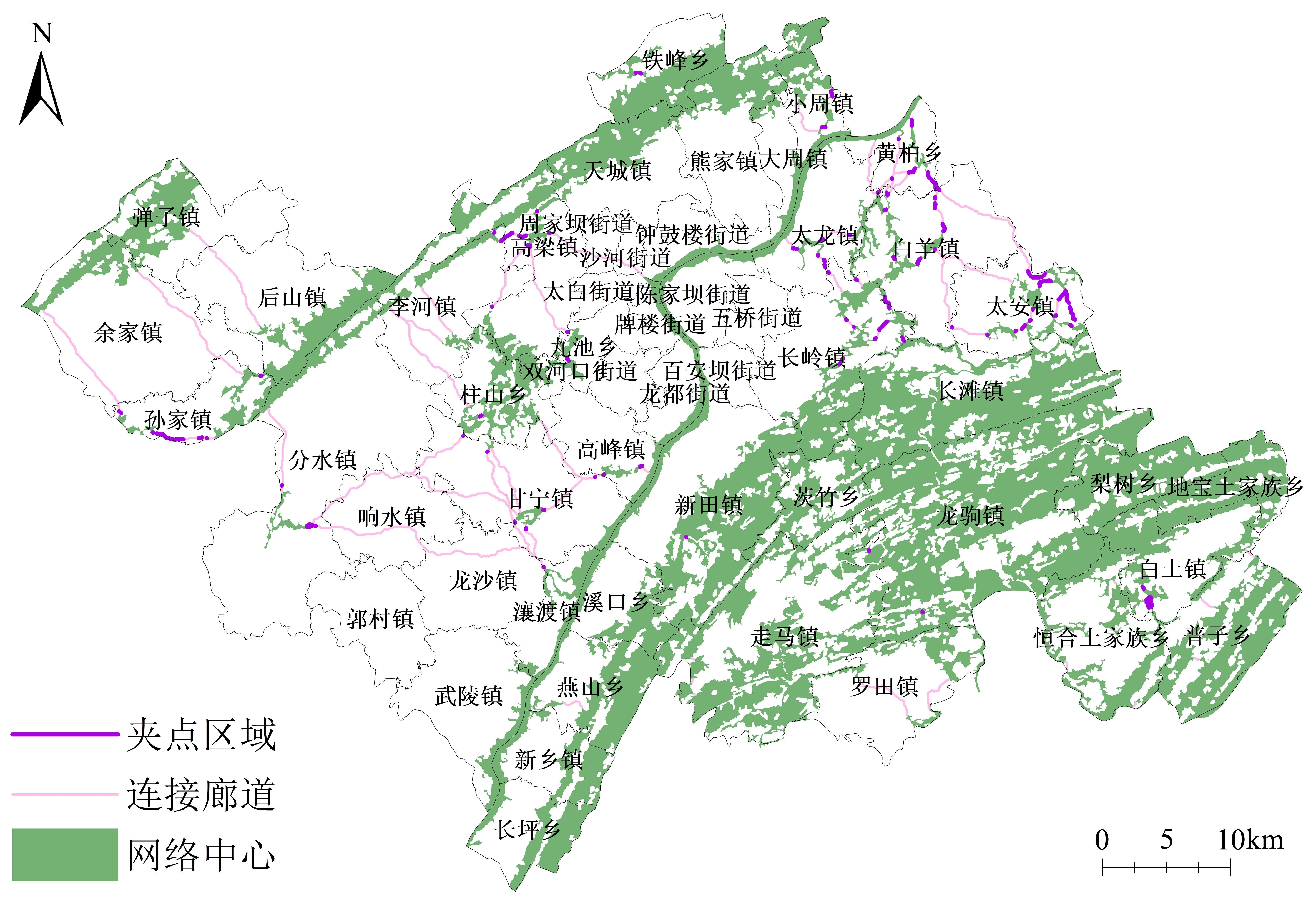
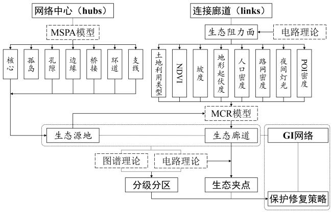
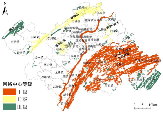
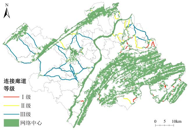
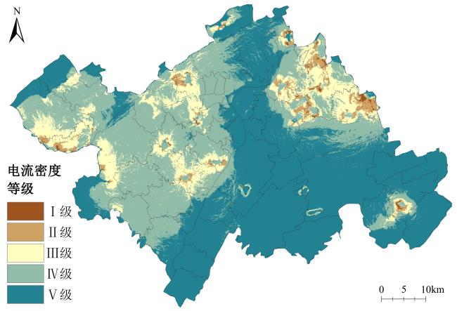
The conflict between ecological protection and town development is particularly pronounced in mountainous towns with fragile ecological environments and constrained construction conditions. Cross-scale Green Infrastructure (GI) is characterized by a balance between ecological protection and human needs. The establishment of a county-level GI network can provide a shared basic framework for the development and biological conservation of mountainous towns. The Wanzhou District of Chongqing has the typical characteristics of a southwestern mountain town with ecological problems such as habitat fragmentation and reduced disturbance resistance. This study was based on the biological flow process, guided by geometric morphology, circuit, and graph theory, and it followed the logic of "hubs, links, and pinch points". First, the morphological spatial pattern analysis method was applied to identify the GI network hubs, and their importance was classified according to the current-flow betweenness centrality index. Next, an ecological resistance surface was established based on multi-source data, and the minimum cumulative resistance model was applied to identify the links. It also calculated their importance and ranked them based on the average resistance, path length, and average value of the connected hubs. Subsequently, the current-flow density distribution was analyzed, and ecological pinch points were extracted in conjunction with the links. According to the results, the GI network of Wanzhou District contains 42 hubs with an area of 996.35 km2, accounting for 28.83% of the total study area. The hubs were generally dense in the east and sparse in the west, forming a pattern of "one screen, three belts, and scattered distribution." Among them, the GI network hubs formed by the Fangdou-Qiyao Mountain group and the Yangtze River and its coastal green areas are of the greatest importance, followed by the Tiefeng Mountain, Dengfeng Reservoir, and the central-eastern forest areas, whereas the small patches scattered in the central southwest-northeast oriented valleys are of the least importance. Additionally, 80 links were identified with a total length of 292.97 km, with long paths and low importance in the eastern region and short paths and high importance in the western region. Furthermore, 142 ecological pinch points were extracted, accounting for 9.60% of the corridor length dominated by land-use types of farmlands (55.89%) and woodlands (35.71%); pinch points were mainly concentrated in the east, which is the key area in guaranteeing the ecological stability of the county GI network. Finally, this study proposes zoning, grading, and precise protection and restoration strategies based on the relative importance of hubs and links and the land-use types of ecological pinch-point areas. These strategies provide a scientific basis for decision-making to coordinate the conservation and development needs of mountain towns.
Ziming Wang , Liang Lyu , Feng Wang . Construction and Restoration Strategies of Green Infrastructure Network in Mountainous Counties Based on Multi-Source Data: A Case Study of Wanzhou District, Chongqing[J]. Tropical Geography, 2024 , 44(2) : 303 -314 . DOI: 10.13284/j.cnki.rddl.003777
表1 研究中的多源数据精度及来源Table 1 Multi-source data accuracy and source in the research |
| 数据类型 | 数据时间 | 空间分辨率 | 数据来源 |
|---|---|---|---|
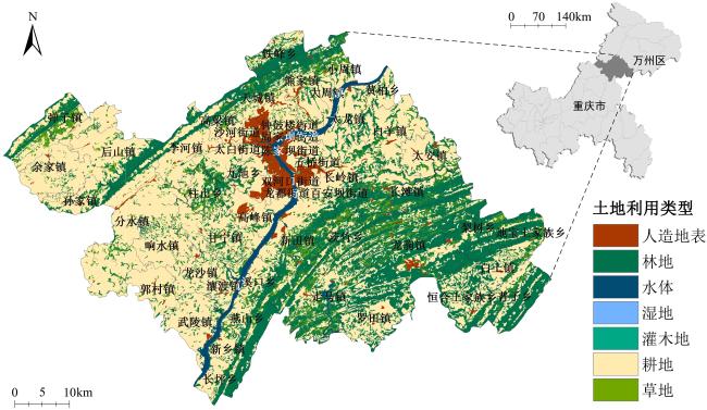
| 土地利用数据 | 2020年 | 30 m | 国家基础地理信息中心-全球地理信息公共产品 (http://www.globeland30.org/) |
| ASTER GDEMV3 30 m分辨率 数字高程数据 | 2009年 | 30 m | 地理空间数据云(https://www.gscloud.cn/) |
| Landsat 8 OLI_TIRS 卫星数字产品 | 2021年 | 30 m(云量<10) | |
| 路网数据(公路和铁路) | 2020年 | — | Open Street Map |
| 夜间灯光数据 | 2020年 | 15arc sec (约475 m) | 地球观测组织Earth Observation Group (https://eogdata.mines.edu/products/vnl/) |
| POI数据 | 2022年 | — | 百度地图 |
| 行政边界数据 | 2019年 | — | 重庆市国土空间总体规划(2021—2035年)(公示版)图册(https://www.cq.gov.cn/zwgk/zfxxgkml/zdjcygk/zdjcyjzj/202105/t20210527_11479457.html) |
表2 不同土地利用类型的基准阻力值Table 2 Baseline resistance values for different land use types |
| 土地利用类型 | 阻力值 |
|---|---|
| 林地 | 10 |
| 灌木地 | 20 |
| 草地 | 30 |
| 湿地 | 50 |
| 水体 | 60 |
| 耕地 | 80 |
| 人造地表 | 100 |
表3 研究区生态阻力因子及权重Table 3 Ecological resistance factors and weights in the study area |
| 阻力因子 | 权重 |
|---|---|
| 土地利用类型 | 0.12 |
| 植被覆盖度(NDVI) | 0.15 |
| 人口密度 | 0.14 |
| 路网密度 | 0.17 |
| 夜间灯光密度 | 0.08 |
| 地形坡度 | 0.10 |
| 地形起伏度 | 0.11 |
| POI密度 | 0.13 |
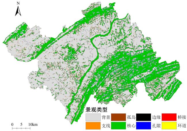
表4 MSPA划分景观要素的分类统计Table 4 Classification statistics of landscape elements classified by MSPA method |
| 景观类型 | 面积/km2 | 占研究区面积比例/% | 占“前景”面积比例/% |
|---|---|---|---|
| 核心 | 1 125.43 | 32.56 | 79.01 |
| 孤岛 | 3.43 | 0.10 | 0.24 |
| 孔隙 | 50.65 | 1.47 | 3.56 |
| 边缘 | 185.83 | 5.38 | 13.05 |
| 环道 | 2.88 | 0.08 | 0.20 |
| 桥接 | 16.36 | 0.47 | 1.15 |
| 支线 | 39.12 | 1.13 | 2.75 |
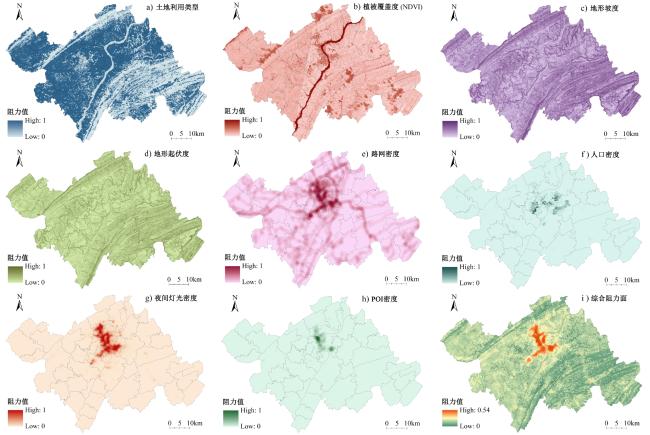
图5 研究区各项阻力因子统计(a. 土地利用类型;b. 植被覆盖度NDVI;c. 地形坡度;d. 地形起伏度;e. 路网密度;f. 人口密度;g. 夜间灯光密度;h. POI密度)和综合阻力面(i)Fig.5 Statistics of each resistance factor (a. land-use type; b. NDVI; c. slope; d. topographic relief; e. road density; f. population density; g. light density; h. POI density) and integrated resistance surface (i) in the study area |

1 《万州区国土空间总体规划(2021—2035)》(公示版). http://www.wz.gov.cn/hdjl_266/yjzj/detail.html?id=2062。
2 “两山理论”,即绿水青山就是金山银山,强调经济发展和环境保护双赢,构建经济与环境协同共进的地球家园。
3 “一干”指长江,“九支”指普里河、苎溪河、大周溪、五桥河、新田河、瀼渡河、石桥河、磨刀溪、泥溪河等主要长江支流。
4 详见《万州区国土空间总体规划(2021—2035)》(公示版). http://www.wz.gov.cn/hdjl_266/yjzj/detail.html?id=2062。
汪子茗:确定总体研究思路,负责论文撰写、修改与校对,参与数据分析;
吕 梁:数据收集、处理与分析,论文修改;
汪 峰:选题及思路、框架,指导论文写作与修改。
|
Benedict M A and Mcmahon E T. 2006. Green Infrastructure: Linking Landscape and Communities. Washington, Covelo, London: Island Press.
|
|
Carroll C, Mcrae B H, and Brookes A. 2012. Use of Linkage Mapping and Centrality Analysis Across Habitat Gradients to Conserve Connectivity of Gray Wolf Populations in Western North America. Conservation Biology, 26(1): 78-87.
|
|
陈炯臻,季翔,葛希辰,王峰. 2022. 基于MSPA和空间句法的县域绿色基础设施网络时空格局演变分析:以徐州市睢宁县为例. 现代城市研究,(10):101-107.
Chen Jongzhen, Ji Xiang, Ge Xichen, and Wang Feng. 2022. Spatial and Temporal Pattern Evolution of County Green Infrastructure Network Based on MSPA and Spatial Syntax: A Case Study of Suining County in Xuzhou City. Modern Urban Research, (10): 101-107.
|
|
重庆市万州区统计局,国家统计局万州调查队. 2022. 万州统计年鉴2022. (2022-10-10)[2023-04-06]. [Wanzhou District Bureau of Statistics and Wanzhou Investigation Team of the National Bureau of Statistics. 2022. Wanzhou Statistical Yearbook 2022. (2022-10-10) [2023-04-06]. http://www.wz.gov.cn/bmjz_89642/bm/tjj/zwgk_94960/fdzdgknr_94962/tjxx/sjfb/tjnj/202210/t20221 010_11173107.html.
|
|
丁金华,孙琦,钱晶. 2022. 基于MSPA-InVEST模型的水网乡村绿色基础设施网络构建研究——以吴江东北片区为例. 西北林学院学报,37(6):183-191.
Ding Jinhua, Sun Qi, and Qian Jing. 2022. Research on the Construction of Green Infrastructure Network in the Water Net Countryside Based on MSPA-InVEST Model: A Case Study of the Northeast Area of Wujiang. Journal of Northwest Forestry University, 37(6): 183-191.
|
|
Diniz M F, Cushman S A, Machado R B, and De Marco Júnior P. 2020. Landscape Connectivity Modeling from the Perspective of Animal Dispersal. Landscape Ecology, 35(6): 41-58.
|
|
Dutta T, Sharma S, Mcrae B H, Roy P S, and Defries R. 2016. Connecting the Dots: Mapping Habitat Connectivity for Tigers in Central India. Regional Environmental Change, 16(4): 53-67.
|
|
范春苗,王志泰,汤娜,邓国平. 2022. 基于形态学空间格局和空间主成分的贵阳市中心城区生态网络构建. 生态学报,42(16):6620-6632.
Fan Chunmiao, Wang Zhitai, Tang Na, and Deng Guoping. 2022. Construction of Ecological Network in Downtown of Guiyang City Based on Morphologically Spatial Pattern and Spatially Principal Component Analysis. Acta Ecologica Sinica, 42(16): 6620-6632.
|
|
方莹,王静,黄隆杨,翟天林. 2020. 基于生态安全格局的国土空间生态保护修复关键区域诊断与识别——以烟台市为例. 自然资源学报,35(1):190-203.
Fang Ying, Wang Jing, Huang Longyang, and Zhai Tianlin. 2020. Determining and Identifying Key Areas of Ecosystem Preservation and Restoration for Territorial Spatial Planning Based on Ecological Security Patterns: A Case Study of Yantai City. Journal of Natural Resources, 35(1): 190-203.
|
|
Grabowski Z J, Mcphearson T, Matsler A M, Groffman P, and Pickett S T. 2022. What Is Green Infrastructure? A Study of Definitions in US City Planning. Frontiers in Ecology and the Environment, 20(3): 152-160.
|
|
Grafius D R, Corstanje R, and Harris J A. 2018. Linking Ecosystem Services, Urban Form and Green Space Configuration Using Multivariate Landscape Metric Analysis. Landscape Ecology, 33(1): 557-573.
|
|
Hermoso V, Morán-Ordóñez A, Lanzas M, and Brotons L. 2020. Designing a Network of Green Infrastructure for the EU. Landscape and Urban Planning, 196(4): 103732.
|
|
金云峰,周艳,沈洁. 2018. 蓝绿生态网络系统修复的LID雨景单元设计方法研究——基于山地水文特征分析. 中国园林,34(10):83-87.
Jin Yunfeng, Zhou Yan, and Shen Jie. 2018. Research on LID Rainfall Unit Design Method for the Blue and Green Ecological Network System-Based on the Analysis of Mountain Hydrological Characteristics. Chinese Landscape Architecture, 34(10): 83-87.
|
|
Knaapen J P, Scheffer M, and Harms B. 1992. Estimating Habitat Isolation in Landscape Planning. Landscape and Urban Planning, 23(1): 1-16.
|
|
李久林,徐建刚,储金龙. 2020. 基于Circuit理论的城市生态安全格局研究——以安庆市为例. 长江流域资源与环境,29(8):1812-1824.
Li Jiulin, Xu Jiangang, and Chu Jinlong. 2020. Constructing the Urban Ecological Security Pattern of Anqing City by Circuit Theory. Resources and Environment in the Yangtze Basin, 29(8): 1812-1824.
|
|
Li P, Cao H, Sun W, and Chen X. 2022. Quantitative Evaluation of the Rebuilding Costs of Ecological Corridors in a Highly Urbanized City: The Perspective of Land Use Adjustment. Ecological Indicators, 141(3): 109130.
|
|
李晓晖,黄海雄,范嗣斌,缪杨兵. 2017. “生态修复、城市修补”的思辨与三亚实践. 规划师,33(3):11-18. [Li Xiaohui, Huang Haixiong, Fan Sibin, and Miao Yangbing. 2017. Analysis on "Renovation and Restoration", Sanya City. Planners, 33(3): 11-18. ]
|
|
李政,丁忆,王亚林,陈静,吴凤敏. 2020. 基于最小累积阻力模型的山地石漠化地区生态安全格局构建:以重庆市南川区为例. 生态与农村环境学报,36(8):1046-1054.
Li Zheng, Ding Yi, Wang Yalin, Chen Jing, and Wu Fengmin. 2020. Constucton of Ecological Security Pattern in Mountain Rocky Desertification Area Based on MCR Model: A Case Study of Nanchuan, Chongqing. Journal of Ecology and Rural Environment, 36(8): 1046-1054.
|
|
刘学,杨春艳,高艳妮,孙倩莹,王世曦,冯朝阳,刘鑫. 2023. 厦门市生态安全格局识别与生态管控区分级管控研究. 生态学报,43(13):5357-5369.
Liu Xue, Yang Chunyan, Gao Yanni, Sun Qianying, Wang Shixi, Feng Zhaoyang, and Liu Xin. 2023. Identification of Ecological Security Pattern and Hierarchical Management of Ecological Control Area in Xiamen. Acta Ecologica Sinica, 43(13): 5357-5369.
|
|
栾博,柴民伟,王鑫. 2017. 绿色基础设施研究进展. 生态学报,37(15):5246-5261.
Luan Bo, Chai Minwei, and Wang Xin. 2017. Review of Development, Frontiers, and Prospects of Green Infrastructure. Acta Ecologica Sinica, 37(15): 5246-5261.
|
|
麦克哈格. 2006. 设计结合自然. 天津:天津大学出版社. [Mcharg I L. 2006. Design with Nature. Tianjin: Tianjin University Press.]
|
|
Mcrae B H. 2006. Isolation by Resistance. Evolution, 60(8): 1551-1561.
|
|
Mcrae B H, Dickson B G, Keitt T H, and Shah V B. 2008. Using Circuit Theory to Model Connectivity in Ecology, Evolution, and Conservation. Ecology, 89(10): 2712-2724.
|
|
蒙吉军,王雅,王晓东,周朕,孙宁. 2016. 基于最小累积阻力模型的贵阳市景观生态安全格局构建. 长江流域资源与环境,25(7):1052-1061.
Meng Jijun, Wang Ya, Wang Xiaodong, Zhou Lian, and Sun Ning. 2016. Construction of Landscape Ecological Security Pattern in Guiyang Based on MCR Model. Resources and Environment in the Yangtze Basin, 25(7): 1052-1061.
|
|
宁琦,朱梓铭,覃盟琳,史倩倩,宋苑震. 2021. 基于MSPA和电路理论的南宁市国土空间生态网络优化研究. 广西大学学报(自然科学版),46(2):306-318.
Ning Qi, Zhu Ziming, Qin Menglin, Shi Qianqian, and Song Yuanzhen. 2021. Research on the Optimization of Territorial Space Ecological Network of Nanning City Based on MSPA and Circuit Theory. Journal of Guangxi University (Natural Science Edition), 46(2): 306-318.
|
|
潘竟虎,王云. 2021. 基于CVOR和电路理论的讨赖河流域生态安全评价及生态格局优化. 生态学报,41(7):2582-2595.
Pan Jinghu and Wang Yun. 2021. Ecological Security Evaluation and Ecological Pattern Optimization in Taolai River Basin Based on CVOR and Circuit Theory. Acta Ecologica Sinica, 41(7): 2582-2595.
|
|
Petsas P, Almpanidou V, and Mazaris A D. 2021. Landscape Connectivity Analysis: New Metrics that Account for Patch Quality, Neighbors' Attributes and Robust Connections. Landscape Ecology, 36(11): 3153-3168.
|
|
仇实,于强,刘泓君,王慧媛,李松,岳德鹏. 2023. 基于生态环境质量评价的酒泉市生态空间网络优化研究. 南京林业大学学报(自然科学版),1-13(2023-07-26)[2023-11-08]. [Qiu Shi, Yu Qiang, Liu Hongjun, Wang Huiyuan, Li Song, and Yue Depeng. 2023. Study on the Optimization of Ecological Spatial Network in Jiuquan City Based on the Evaluation of Ecological Environment Quality. Journal of Nanjing Forestry University (Natural Sciences Edition), 1-13 (2023-07-26) [2023-11-08]. http://kns.cnki.net/kcms/detail/32.1161.s.20230725.1344.004.html.
|
|
邵润钰,罗紫薇,胡希军,王烨梓,张九月. 2023. 基于MSPA和MCR模型的株洲市生态网络构建与优化. 西北林学院学报,1-15(2023-04-03)[2023-11-08]. http://kns.cnki.net/kcms/detail/61.1202.S.20230403.1314.006.html.
Shao Runyu, Luo Ziwei, Hu Xijun, Wang Yezi, and Zhang Jiuyue. 2023. The Construction of Zhuzhou Ecological Network Based on MSPA and MCR Model. Journal of Northwest Forestry University, 1-15 (2023-04-03)[2023-11-08]. http://kns.cnki.net/kcms/detail/61.1202.S.20230403.1314.006.html.
|
|
Soille P and Vogt P. 2009. Morphological Segmentation of Binary Patterns. Pattern Recognition Letters, 30(4): 456-459.
|
|
宋利利,秦明周. 2016. 整合电路理论的生态廊道及其重要性识别. 应用生态学报,27(10):3344-3352.
Song Lili and Qin Mingzhou. 2016. Identification of Ecological Corridors and Its Importance by Integrating Circuit Theory. Chinese Journal of Applied Ecology, 27(10): 3344-3352.
|
|
陶培峰,李萍,丁忆,刘建,杨光谱,肖禾. 2022. 基于生态重要性评价与最小累积阻力模型的重庆市生态安全格局构建. 测绘通报,(1):15-20,38.
Tao Peifeng, Li Ping, Ding Yi, Liu Jian, Yang Guangpu, and Xiao He. 2022. Construction of Ecological Security Pattern Based on Ecological Importance Assessment and Minimum Cumulative Resistance Model in Chongging City. Bulletin of Surveying and Mapping, (1): 15-20, 38.
|
|
王回茴,李汉廷,谢苗苗,许萌,李少玲,白中科. 2020. 资源型城市工矿用地系统修复的生态安全格局构建. 自然资源学报,35(1):162-173.
Wang Huihui, Li Hanting, Xie Miaomiao, Xu Meng, Li Shaoling, and Bai Zhongke. 2020. Construction of Ecological Security Pattern for Systematic Restoration of Industrial and Mining Land in Resource-Based Cities. Journal of Natural Resources, 35(1): 162-173.
|
|
王永衡,李春林,王昊,梁碧苗,吕建树. 2022. 绿色基础设施的生态环境领域研究现状及热点. 生态学报,42(6):2510-2521.
Wang Yongheng, Li Chunlin, Wang Hao, Liang Bimiao, and Lyu Jianshu. 2022. Current Status and Hot Spots of Research in the Field of Ecology and Environment of Green Infrastructure. Acta Ecologica Sinica, 42(6): 2510-2521.
|
|
王越,林箐. 2017. 基于MSPA的城市绿地生态网络规划思路的转变与规划方法探究. 中国园林,33(5):68-73.
Wang Yue and Lin Jing. 2017. The Transformation of Planning Ideas and the Exploration of Planning Methods of Urban Green Space Ecological Network Based on MSPA. Chinese Landscape Architecture, 33(5): 68-73.
|
|
王云才,黄俊达. 2019. 生态智慧引导下的太原市山地生态修复逻辑与策略. 中国园林,35(7):56-60.
Wang Yuncai and Huang Junda. 2019. The Logic and Strategies of Mountain Ecologica Restoration in Taiyuan Inspired by Ecological Wisdom. Chinese Landscape Architecture, 35(7): 56-60.
|
|
Wei Q, Halike A, Yao K, Chen L, and Balati M. 2022. Construction and Optimization of Ecological Security Pattern in Ebinur Lake Basin Based on MSPA-MCR Models. Ecological Indicators, 138(2): 108857.
|
|
邬志龙,杨济瑜,谢花林. 2022. 南方丘陵山区生态安全格局构建与优化修复——以瑞金市为例. 生态学报,42(10):3998-4010.
Wu Zhilong, Yang Jiyu, and Xie Hualin. 2022. Construction, Optimization and Restoration of Ecological Security Pattern in the Southern Hilly and Mountainous Region of China: A Case Study in Ruijin City. Acta Ecologica Sinica, 42(10): 3998-4010.
|
|
薛建辉,周之栋,吴永波. 2022. 喀斯特石漠化山地退化土壤生态修复研究进展. 南京林业大学学报(自然科学版),46(6):135-145.
Xue Jianhui, Zhou Zhidong, and Wu Yongbo. 2022. Research Progresses on Ecological Remediation of the Degraded Soil in Karst Rocky Desertification Mountainous Areas. Journal of Nanjing Forestry University (Natural Sciences Edition), 46(6): 135-145.
|
|
杨志广,蒋志云,郭程轩,杨晓晶,许晓君,李潇,胡中民,周厚云. 2018. 基于形态空间格局分析和最小累积阻力模型的广州市生态网络构建. 应用生态学报,29(10):3367-3376.
Yang Zhiguang, Jiang Zhiyun, Guo Chengxuan, Yang Xiaojing, Xu Xiaojun, Li Xiao, Hu Zhongmin, and Zhou Houyun. 2018. Construction of Ecological Network Using Morphological Spatial Pattern Analysis and Minimal Cumulative Resistance Models in Guangzhou City, China. Chinese Journal of Applied Ecology, 29(10): 3367-3376.
|
|
于亚平,尹海伟,孔繁花,王晶晶,徐文彬. 2016. 基于MSPA的南京市绿色基础设施网络格局时空变化分析. 生态学杂志,35(6):1608-1616.
Yu Yaping, Yin Haiwei, Kong Fanhua, Wang Jingjing, and Xu Wenbin. 2016. Analysis of the Temporal and Spatial Pattern of the Green Infrastructure Network in Nanjing, Based on MSPA. Chinese Journal of Ecology, 35(6): 1608-1616.
|
|
曾真,艾婧文,王梓凌,何天友,郑郁善. 2023. 三明市区景观格局时空演变及生态网络构建研究. 生态与农村环境学报,1-13(2023-03-27)[2023-11-08]. [Zeng Zhen, Ai Jingwen, Wang Ziling, He Tianyou, and Zheng Yushan. 2023. Research on the Spatial and Temporal Evolution of Landscape Pattern in Sanming Urban Area and the Construction of Ecological Network. Journal of Ecology and Rural Environment,1-13 (2023-03-27) [2023-11-08]. https://doi.org/10.19741/j.issn.1673-4831.2022.1013.
|
|
张启斌,刘冬悦,李倩,于强,宋宏利,李世冉. 2022. 荒漠绿洲交错区生态空间网络粒度效应研究. 农业机械学报,53(4):199-207.
Zhang Qibin, Liu Dongyue, Li Qian, Yu Qiang, Song Hongli, and Li Shiran. 2022. Grain-Size Effect of Potential Ecological Spatial Network in Desert Oasis Ecotone. Transactions of the Chinese Society for Agricultural Machinery, 53(4): 199-207.
|
|
周璟,王宏卫,谈波,马晨,王晓琴,代芯妍. 2022. 开都河流域生态安全格局构建与生态修复分区识别. 生态学报,42(24):10127-10137.
Zhou Jing, Wang Hongwei, Tan Bo, Ma Chen, Wang Xiaoqin, and Dai Xinyan. 2022. Construction of Ecological Security Pattern and Identification of Ecological Rehabilitation Zones in Kaidu River Basin. Acta Ecologica Sinica, 42(24): 10127-10137.
|
|
周媛. 2019. 多元目标导向下的成都中心城区绿地生态网络构建. 浙江农林大学学报,36(2):359-365.
Zhou Yuan. 2019. Developing Urban Greenspace Ecological Network in Chengdu City Center Based on Multiple Objectives. Journal of Zhejiang A & F University, 36(2): 359-365.
|
|
朱捷,苏杰,尹海伟,孔繁花. 2020. 基于源地综合识别与多尺度嵌套的徐州生态网络构建. 自然资源学报,35(8):1986-2001.
Zhu Jie, Su Jie, Yin Haiwei, and Kong Fanhua. 2020. Construction of Xuzhou Ecological Network Based on Comprehensive Sources Identification and Mmulti-Scale Nesting. Journal of Natural Resources, 35(8): 1986-2001.
|
/
| 〈 |
|
〉 |
