
Granite Landforms and Their Origins in the Queshi Area of Shantou, Guangdong, China
Received date: 2023-05-23
Revised date: 2023-09-14
Online published: 2024-03-13
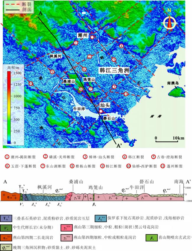
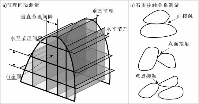
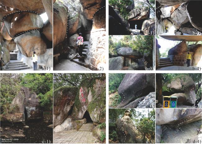
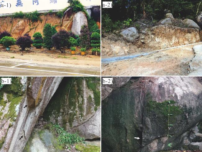
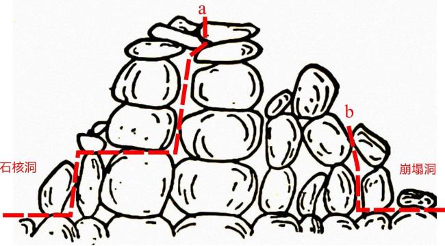
Granite, a principal component of continental crust, emerges at the Earth's surface through crustal movements, creating diverse landforms. The Queshi region, comparable to Huangshan in its granite hilly landscape, stands as a representative granite landform in China, yet its origin remains incompletely studied. This investigation utilizes surface landscape and cave analyses to elucidate the characteristics and determining factors of granite landforms in the Queshi region, to comprehend the formation mechanisms of these unique landforms. In the surface investigation, field surveys and aerial photography, employing a DJI Phantom 4 RTK drone, were utilized to measure the morphology and dimensions of exposed rock egg sizes on cliff faces and joint spacing. The survey results facilitated an overall classification of surficial landscapes, encompassing the proportion of rock egg sizes on the mountain and the spacing between the vertical and horizontal joints. To assess mountain development concerning stone eggs, cave orientation and elevation were determined using a rangefinder and GPS measurements, while different contact relationships between stone eggs were investigated. By amalgamating domestic and international granite development theories with field investigation results, this study delves into the geological structure of the surrounding areas, the characteristics of granite landforms, and the factors governing the landform formation of granite geomorphology in the Queshi area. The findings indicate that 1) rocks in the Queshi scenic area have evolved into various rock eggs through subsequent weathering processes, manifesting as grotesque formations resembling humans, genies, or animals, and 2) granite mountain bodies in the Queshi region can be categorized into three types: rock egg mountains, peak forest mountains, and steamed bun mountains. Stone egg mountains exhibit a unique form with round, large stone eggs stacked atop each other, peak forest mountains comprise elongated rock eggs or blocks due to narrowly spaced vertical joints, while steamed bun mountains lack obvious joints and fractures, presenting gently rounded mountain shapes. Furthermore, 3) granite caves in the Queshi scenic area are classified into four categories based on different formation processes: core stone caves, collapsed caves/rock egg caves, fissure caves, and niches. Core stone caves form when weathered material in the gaps between stone cores is carried away by flowing water without causing any movement of the core stones. Fissure caves, relatively rare and small in scale in the Queshi scenic area, are formed along large fractures created by bedrock breaks. Niches are concave grooves formed at the base of rock bodies or rock eggs, buried by rock debris or soil, storing more rainwater than bare rock surfaces and enhancing chemical weathering. After external runoff removed the debris, the rock base became exposed and formed concave grooves. Finally, 4) the weathering crusts of the Queshi region formed before the subsidence of the Rongjiang fault, during which the Queshi Mountains experienced relative uplift. Consequently, the weathering crusts continued to weather, forming the present granite landforms. Weathering occurs through the rock joints of the parent rock of the weathered crusts, with the degree of damage to the rock determined by joint density. The greater the joint density, the more extensive the damage; conversely, the smaller the joint density, the less the damage. Therefore, mountain morphological differences in the Queshi region are primarily caused by variations in joint spacing rather than climate or rock-type influences.
Mingkun Qiu , Wei Wang , Xiaohao Wen , Min Chen , Chen Wang , Jing Feng . Granite Landforms and Their Origins in the Queshi Area of Shantou, Guangdong, China[J]. Tropical Geography, 2024 , 44(3) : 403 -414 . DOI: 10.13284/j.cnki.rddl.003801
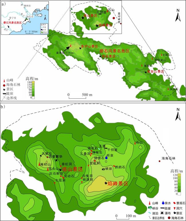
图1 研究区域及礐石花岗岩地貌景观分布(a. 礐石风景名胜区;b. 塔山景区-焰峰景区)Fig.1 Distribution of the study area and granite landscape (a. Yanshi Scenic Area; b. Tashan Scenic Area-Yanfeng Scenic Area) |
表1 千仞崖与石山垂直与水平节理间隔统计结果Table 1 Statistics of vertical and horizontal joint intervals of the Shishan hill and Qianren Cliff |
| 地名 | 节理间隔 | 平均值 | 极小值 | 极大值 |
|---|---|---|---|---|
| 千仞崖 | 水平节理 | 14.21 | 6.22 | 22.16 |
| 垂直节理 | 10.69 | 4.67 | 17.26 | |
| 石山 | 水平节理 | 10.29 | 1.82 | 18.38 |
| 垂直节理 | 4.58 | 1.55 | 7.26 |
表2 石山和千仞崖垂直与水平节理分布及间隔占比Table 2 Vertical and horizontal joint distribution and interval proportion of the Shishan and Qianren Cliffs |
| 地名 | 节理分布 | 水平节理间隔 | 垂直节理间隔 |
|---|---|---|---|
| 石 山 |  | 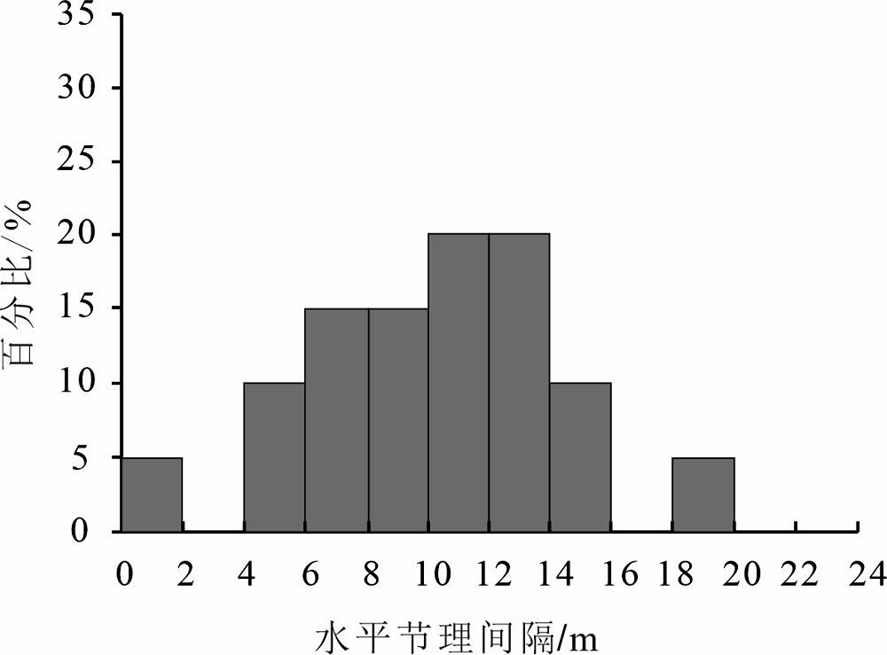 | 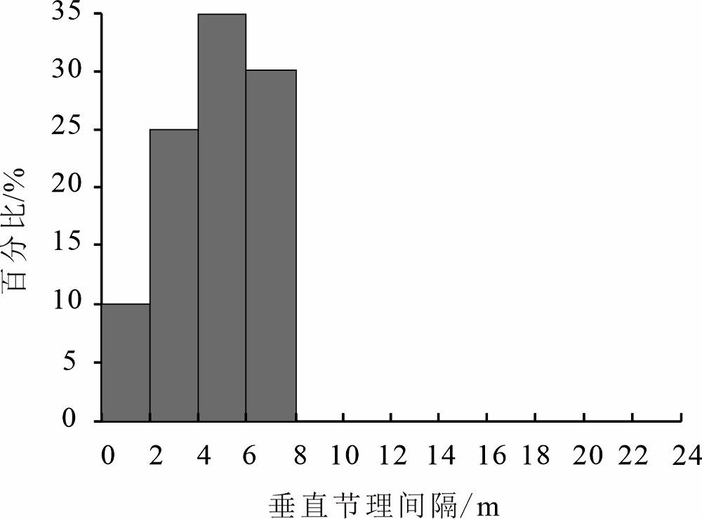 |
| 千 仞 崖 | 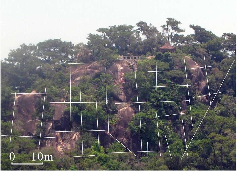 | 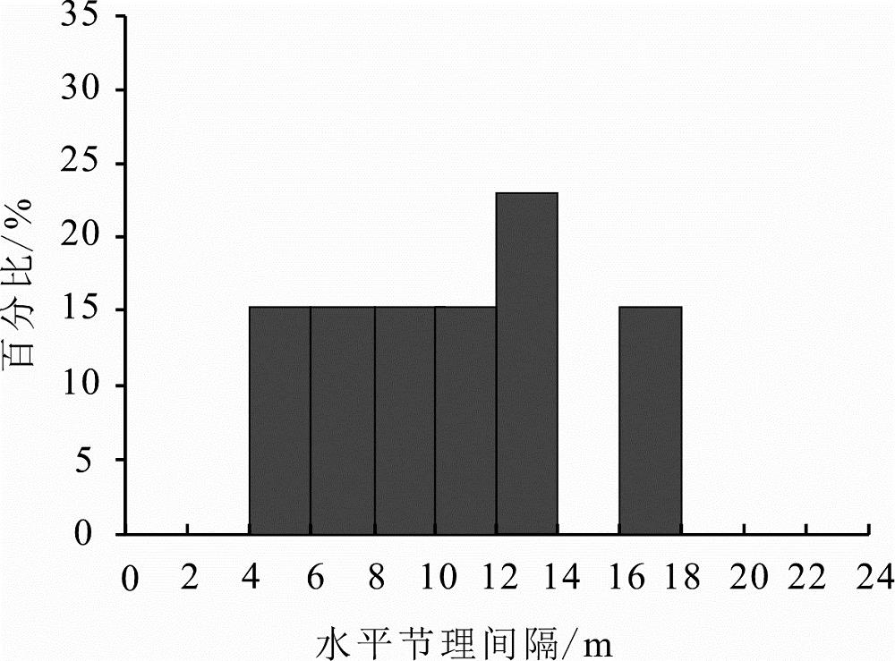 | 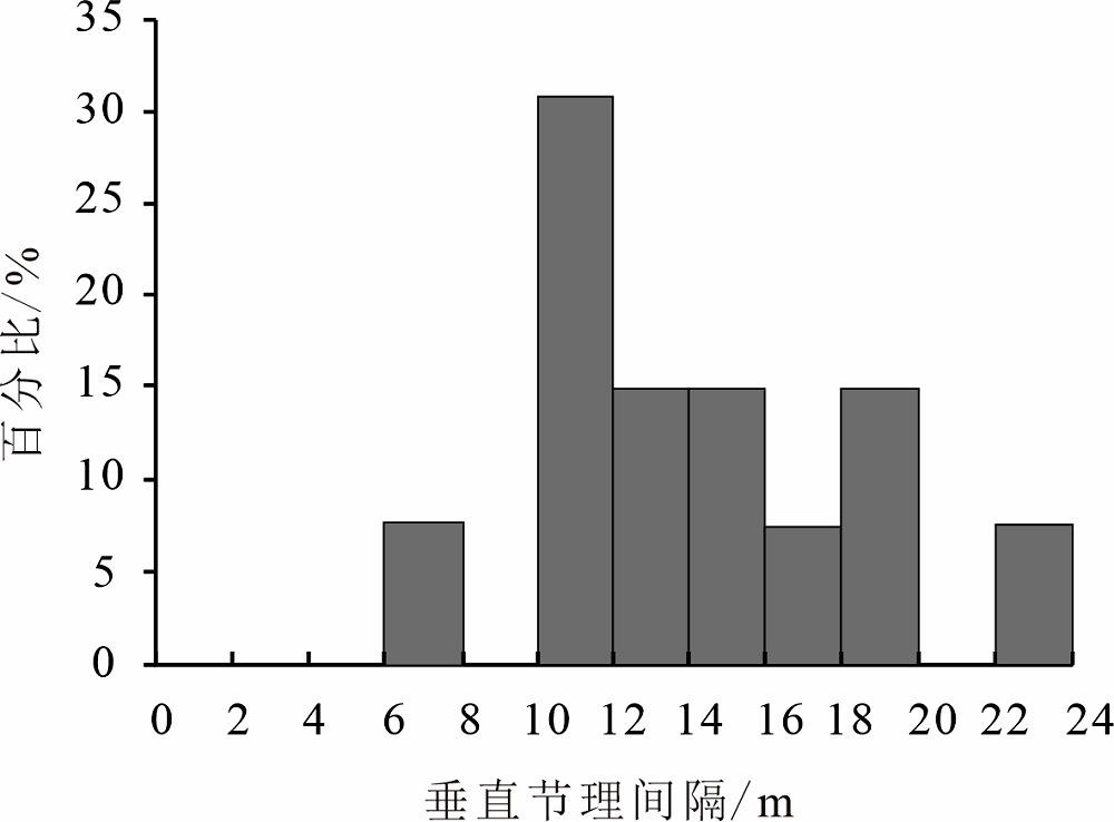 |
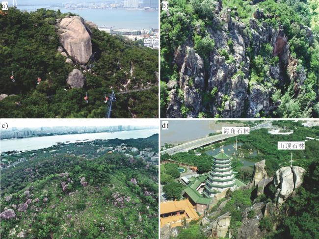
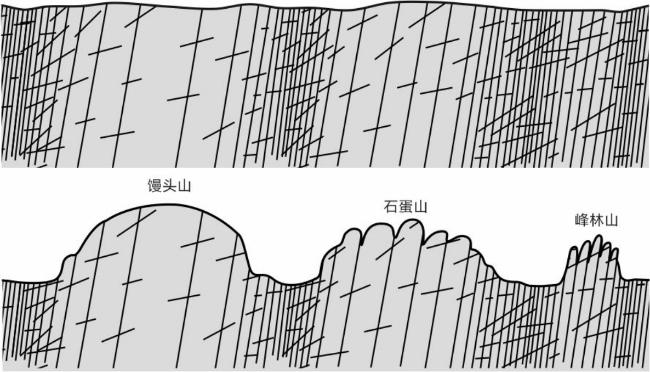
图6 礐石风景区的花岗岩山体类型 [ a. 石蛋山(百里繁华);b. 峰林山(石山);c. 馒头山;d. 石山山顶石林和山脚的海角石林 ]Fig.6 Granite mountain types in the Queshi Scenic Area [a. Stone egg mountain (Hundred Miles of Prosperity); b. Stone forest mountain (Shishan hill); c. Steamed bun mountain; d. Stone Pillars at the top of Shishan hill and Cape Rock Forest at the foot of the mountain] |
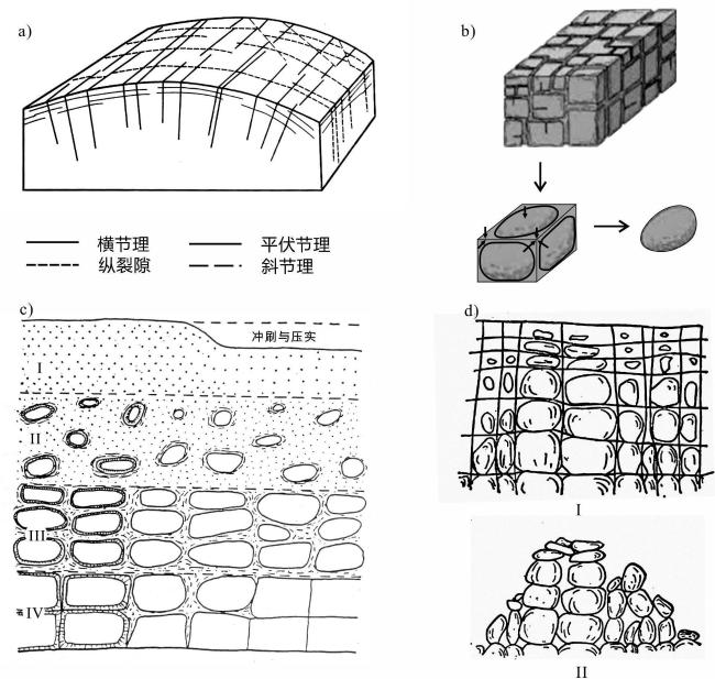
图8 节理与风化在花岗岩地貌发育的控制作用[ a. 花岗岩节理类型(Cloos, 1925);b. 球状风化;c. 花岗岩风化剖面(Ruxton and Berry, 1957);d. 花岗岩岩岗的形成(Linton, 1955)] Fig.8 The controlling role of joints and weathering in the development of granite landforms [a. types of granite joints (Cloos, 1925); b. spherical weathering; c. granite weathering profiles (Ruxton and Berry, 1957); d. formation of granite hills (Linton, 1955) ] |
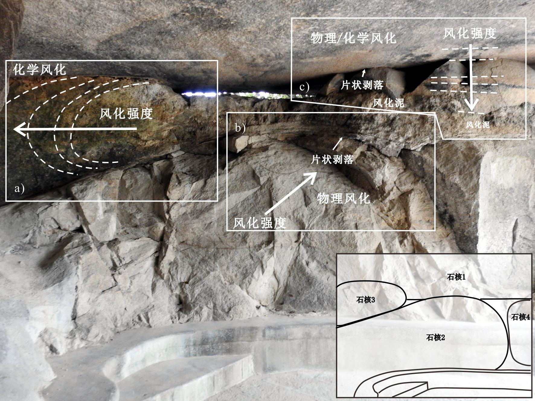
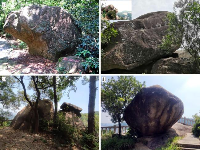
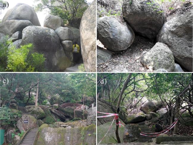
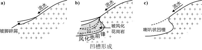
图9 石核间发生的球状风化作用类型 Fig.9 The type of spherical weathering that occurs between rock cores |

1 汕头市礐石风景名胜区自然与文化旅游资源资料汇编,2014。
2 粤东地质图1∶200 000(广东省冶金地质勘探队931队,1982)。
邱明昆:论文撰写,野外调查;
王 为:论文选题与修改,研究框架制定与野外调查技术指导;
温小浩、陈敏、王晨、冯静:野外调查。
|
Chiu T N. 1983. A Geography of Hong Kong. Oxford: Oxford University Press.
|
|
Cloos H. 1925. Einführung in Die Tektonische Behandlung Magmatischer Erscheinungen (Granittektonik)-Das Riesengebirge in Schlesien: Bau, Bildg u. State of California: Gebr. Bortraeger.
|
|
陈国能. 1984. 潮汕平原第四纪断块运动. 华南地震,(4):4-21.
Chen Guoneng. 1984. Quaternary Fault Block Movement in the Chaoshan Plain. South China Earthquake, (4): 4-21.
|
|
陈璟元. 2015. 福建东北部白垩纪闪长岩-花岗岩-正长岩成因:对大陆地壳再造的启示. 北京:中国科学院大学.
Chen Jingyuan. 2015. Origin of Cretaceous Diorite Granite Syenite in Northeastern Fujian: Implications for Continental Crust Reconstruction. Beijing: University of the Chinese Academy of Sciences.
|
|
陈伟光. 1984. 广东潮汕地区沉积盆地发育的若干特征. 华南地震,(2):20-30.
Chen Weiguang. 1984. Several Characteristics of Sedimentary Basin Development in the Chaoshan Area of Guangdong. South China Earthquake, (2): 20-30.
|
|
崔之久,杨建强,陈艺鑫. 2007. 中国花岗岩地貌的类型特征与演化. 地理学报,62(7):675-690.
Cui Zhijiu, Yang Jianqiang, and Chen Yixin. 2007. Type Characteristics and Evolution of Granite Landforms in China. Journal of Geography, 62(7): 675-690.
|
|
崔之久,陈艺鑫,杨晓燕. 2009. 黄山花岗岩地貌特征、分布与演化模式. 科学通报,54(21):3364-3373.
Cui Zhijiu, Chen Yixin, and Yang Xiaoyan. 2009. Landform Characteristics, Distribution and Evolution Model of Mount Huangshan Granite. Science Bulletin, 54 (21): 3364-3373.
|
|
董传万,杨永峰,闫强,竺国强. 2007. 浙江花岗岩地貌特征与形成过程. 地质论评,(S1):132-137.
Dong Chuanwan, Yang Yongfeng, Yan Qiang, and Zhu Guoqiang. 2007. Geomorphic Characteristics and Formation Process of Granite in Zhejiang. Geological Review, (S1): 132-137.
|
|
冯郑凭. 2022. 基于文旅融合的西洋近代建筑保护与活化研究——以广东省汕头市礐石风景名胜区为例. 城市观察,(2):135-148,164.
Feng Zhengping. 2022. Research on the Protection and Activation of Western Modern Architecture Based on the Integration of Culture and Tourism: A Case Study of Yanshi Scenic Area in Shantou City, Guangdong Province. Urban Observation, (2): 135-148, 164.
|
|
胡广韬,杨文元. 1984. 工程地质学. 北京:地质出版社.
Hu Guangtao and Yang Wenyuan. 1984. Engineering Geology. Beijing: Geological Publishing House.
|
|
Linton D L. 1950. The Scenery of the Cairngorm Mountains. Journal of the Manchester Geographical Society, 55: 1-14.
|
|
Linton D L. 1955. The Problem of Tors. The Geographical Journal, 121(4): 470-487.
|
|
李鹏举,李红英,韩亚超,邱骏挺,余心起. 2014. 皖赣两省地质公园造景花岗岩的岩石特征、形成时代及景观成因. 地质论评,60(6):1348-1358.
Li Pengju, Li Hongying, Han Yachao, Qiu Junting, and Yu Xinqi. 2014. Rock Characteristics, Formation Era, and Landscape Genesis of Scenic Granite in Geological Parks of Anhui and Jiangxi Provinces. Geological Review, 60(6): 1348-1358.
|
|
李平日,黄镇国. 1987. 韩江三角洲. 北京:海洋出版社.
Li Pingri and Huang Zhenguo. 1987. Han River Delta. Beijing: Ocean Publishing House.
|
|
李志文,郭福生,孙丽,黄宝华. 2017. 南昌市梅岭花岗岩石蛋地貌的特征与发育机制初探. 地质论评,63(5):1281-1292.
Li Zhiwen, Guo Fusheng, Sun Li, and Huang Baohua. 2017. Preliminary Study on the Characteristics and Development Mechanism of Granite Egg Landform in Meiling, Nanchang City. Geological Review, 63 (5): 1281-1292.
|
|
Migon P. 2006. Granite Landscapes of the World. New York: Oxford University Press.
|
|
彭世良,陈文光. 2010. 衡山花岗岩地貌研究. 热带地理,30(4):348-352.
Peng Shiliang and Chen Wenguang. 2010. Research on the Landform of Granite in Hengshan. Tropical Geography, 30(4): 348-352.
|
|
齐岩辛,万治义,陈美君,邹霞. 2016. 浙江大明山花岗岩地貌景观特征与演化. 科技通报,32(2):66-70.
Qi Yanxin, Wan Zhiyi, Chen Meijun, and Zou Xia. 2016. Landscape Characteristics and Evolution of Granite Landform in Daming Mountain, Zhejiang. Science and Technology Bulletin, 32(2): 66-70.
|
|
Ruxton B P and Berry L. 1957. Weathering of Granite and Associated Erosional Features in Hong Kong. Geological Society of America Bulletin, 68 (10): 1263-1292.
|
|
宋毅盛,陈文彬,潘华,张志中,何振勤,程小久,曾强,佘奕平,张俊杰. 2012. 练江平原第四系的时代. 吉林大学学报(地球科学版),(S1):154-161.
Song Yisheng, Chen Wenbin, Pan Hua, Zhang Zhizhong, He Zhenqin, Cheng Xiaojiu, Zeng Qiang, She Yiping, and Zhang Junjie. 2012. Geological Age of Quaternary Series in Lianjiang Plain. Journal of Jilin University(Earth Science Edition), (S1): 154-161.
|
|
Twidale C R. 1962. Steepened Margins of Inselbergs from North-Western Eyre Peninsula. South Australia. Zeitschrift fur Geomorphologie, 6: 51-69.
|
|
魏罕蓉,张招崇. 2007. 花岗岩地貌类型及其形成机制初步分析. 地质论评,(S1):147-159.
Wei Hanrong and Zhang Zhaochong. 2007. Preliminary Analysis of Granite Landform Types and Their Formation Mechanisms. Geological Review, (S1): 147-159.
|
|
王建华,郑卓,吴超羽. 1997. 潮汕平原晚第四纪沉积相与古环境演变. 中山大学学报(自然科学版),(1):96-101.
Wang Jianhua, Zheng Zhuo, and Wu Chaoyu. 1997. Late Quaternary Sedimentary Facies and Paleoenvironmental Evolution in the Chaoshan Plain. Journal of Sun Yat sen University (Natural Science Edition), (1): 96-101.
|
|
叶张煌,尹斌,刘嘉麒,王安建,陈安泽,闫强. 2014. 江西省“三清山式”花岗岩地貌景观发育机制探讨. 地球学报,35(6):769-775.
Ye Zhanghuang, Yin Bin, Liu Jiaqi, Wang Anjian, Chen Anze, and Yan Qiang. 2014. Discussion on the Development Mechanism of "Mount Sanqing Style" Granite Landscape in Jiangxi Province. Acta Geologica Sinica, 35(6): 769-775.
|
|
尹祝,郑宝美,吴鑫蕊. 2018. 江西灵山地质公园花岗岩地质特征与地貌成因分析. 环境与发展,30(9):206-207.
Yin Zhu, Zheng Baomei, and Wu Xinrui. 2018. Geological Characteristics and Geomorphological Origin Analysis of Granite in Lingshan Geopark, Jiangxi. Environment and Development, 30(9): 206-207.
|
|
Zhong J, Ling K, Yang M, Shen Q, Abbas M, and Lai Z. 2022. Radiocarbon and OSL Dating on Cores from the Chaoshan Delta in the Coastal South China Sea. Frontiers in Marine Science, 9: 1030841.
|
|
曾昭璇. 1960. 岩石地形学. 北京:地质出版社.
Zeng Zhaoxuan. 1960. Rock Topography. Beijing: Geological Publishing House.
|
/
| 〈 |
|
〉 |

