
Integrated Impacts of Urban Spatial Form on Thermal Environment and Zonal Regulation under the Perspective of Spatial Heterogeneity
Received date: 2023-11-27
Revised date: 2024-01-27
Online published: 2025-01-03
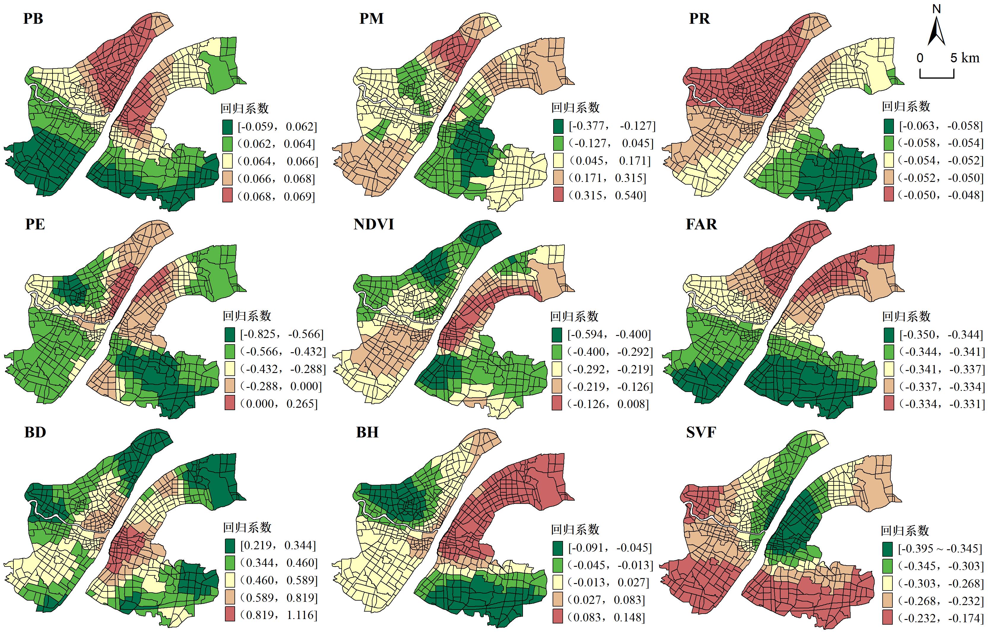
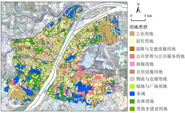
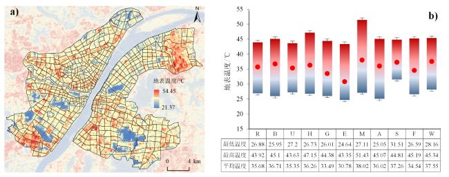
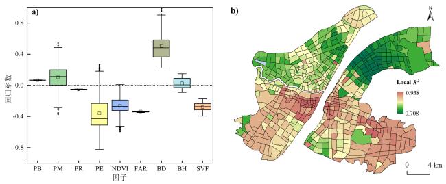
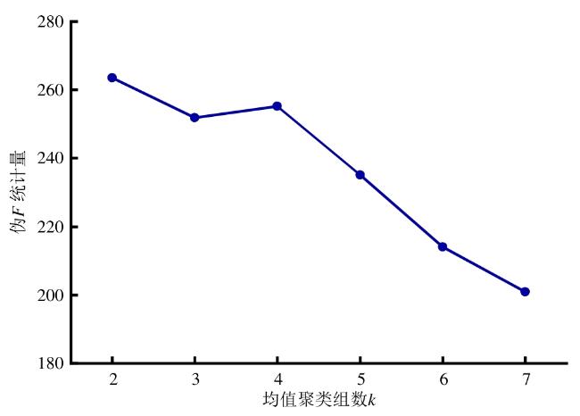
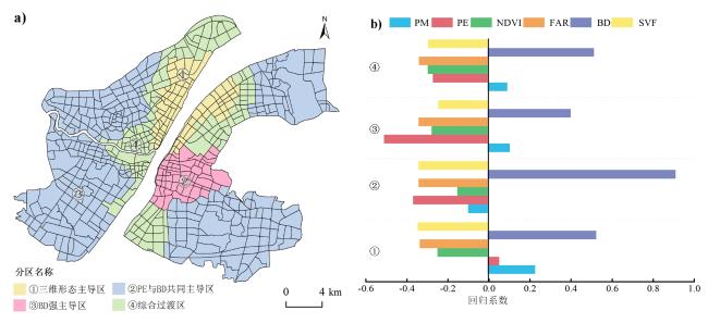
Analyzing the spatial relationship between urban spatial patterns and the thermal environment and quantifying zoning to regulate the urban thermal environment according to local conditions is essential. Previous research on the spatial heterogeneity of factors influencing thermal environments is lacking, and there are shortcomings in the actionability of thermal environment regulation. This study takes the main urban area of Wuhan as an example, based on multi-source spatial data such as Landsat-8 remote sensing images, urban land classification, and buildings, integrates geodetectors and a geographically weighted regression model (MGWR) to investigate the mechanism of the influence of the urban form on the thermal environment under the control unit at the global and local levels, and finally utilizes the K-mean clustering approach to perform impact zoning. First, the high-temperature areas in the main urban area of Wuhan are mainly located in the core area of the old city of Hankou and the Wuchang District, which are located on both sides of the Yangtze River, as well as in the industrial zones northeast and southwest of the city. In terms of land-use types, industrial, logistics and warehousing, and street and transportation had higher average surface temperatures, whereas water area, green space and square, and agricultural and forestry had lower average surface temperatures. Second, the three-dimensional (3D) building indicator had a greater overall impact on the thermal environment than the two-dimensional (2D) urban land-use type indicator. Building density (q = 0.479) was the dominant factor affecting the thermal environment. While the share of water area in 2D form had the strongest explanatory power, the other indicators were relatively weaker. Third, there was spatial heterogeneity in the impact of indicators on the thermal environment, with strong locally driven characteristics for indicators such as vegetation cover, percentage of industrial land area, and building density (BD). Finally, according to the MGWR regression coefficients of each indicator, the main urban area of Wuhan was divided into four types of impact zones, and the intensity and direction of the impact of indicators in different impact zones changed, which confirms the necessity of a zoning policy. 3D buildings form the dominant zone and the BD strong dominant zone are suggested to adjust the urban building form as the main goal, the percentage of water area and BD co-dominant zones are suggested to optimize the urban blue-green space as the main regulation goal to improve its cooling efficiency, and the integrated transition zone is suggested to synergistically optimize the 2D/3D urban spatial form. In conclusion, from the perspective of planning practice, combined with the different impact characteristics of each control area, we propose a differentiated control strategy combining "planning units + planning indicators," which provides a practical approach to optimize the climate-friendly urban form.
Jinlong Yan , Chaohui Yin , Zihao An , Simin Zhang , Qian Wen , Weiqiang Chen . Integrated Impacts of Urban Spatial Form on Thermal Environment and Zonal Regulation under the Perspective of Spatial Heterogeneity[J]. Tropical Geography, 2025 , 45(1) : 143 -154 . DOI: 10.13284/j.cnki.rddl.20230916
表1 指标计算方法汇总Table 1 Summary of index calculation methods |
| 维度 | 指标 | 计算公式 | 参数说明 | |
|---|---|---|---|---|
| 因变量 | 地表温度 | (4) | 采用单窗算法反演地表温度,步骤参见文献 (覃志豪 等,2001;胡德勇 等,2017) | |
| 自 变 量 | 二维 指标 | 用地类型面积占比 | (5) | 式中: 为某类用地类型在单元内的总面积;B为单元总面积 |
| 归一化植被指数 | (6) | 式中: 为近红外波段; 为红光波段 | ||
| 三维 指标 | 建筑容积率 | (7) | 式中:Ai 为建筑i的基底面积;Hi 为建筑i的楼层数;A为单元 总面积 | |
| 建筑密度 | (8) | 式中:Ai 为建筑i的基底面积;A为研究单元总面积 | ||
| 建筑高度 | (9) | 式中:Hi 为单元内所有建筑i的总高度;n为建筑的数量 | ||
| 天空开阔度 | (10) | 式中:采用三维矢量估算法计算SVF,计算过程参见文献 (Scarano & Mancini, 2017) | ||
表2 热环境影响因子探测结果Table 2 Detection results of influencing factors of thermal environment |
| 因子 | q统计量 | P值 |
|---|---|---|
| PB | 0.142 | 0.000 |
| PM | 0.068 | 0.739 |
| PR | 0.082 | 0.000 |
| PE | 0.380 | 0.000 |
| NDVI | 0.199 | 0.000 |
| FAR | 0.283 | 0.000 |
| BD | 0.479 | 0.000 |
| BH | 0.050 | 0.000 |
| SVF | 0.281 | 0.000 |
|
表3 MGWR模型总体回归结果Table 3 Overall results of MGWR models |
| 影响因子 | VIF | ||
|---|---|---|---|
| PB | 0.065 | 2.068** | 1.369 |
| PM | 0.102 | 3.024*** | 1.444 |
| PR | -0.052 | 2.073** | 2.404 |
| PE | -0.363 | 3.067*** | 1.570 |
| NDVI | -0.261 | 2.994*** | 1.574 |
| FAR | -0.338 | 1.993** | 7.151 |
| BD | 0.505 | 3.106*** | 5.605 |
| BH | 0.022 | 2.661*** | 2.319 |
| SVF | -0.278 | 2.512** | 3.351 |
|
1 https://glovis.usgs.gov/
2 http://atmcorr.gsfc.uasa.gov/
3 https://lbs.amap.com/
4 http://202.103.25.26/webcms/
晏金龙:数据处理与分析、文章撰写与修改;
银超慧:研究思路指导、内容审查、基金支持;
安子豪:文章修改与校对;
张思敏:数据处理;
文 倩:资金支持;
陈伟强:技术指导;
|
Fotheringham A S, Yang Wenbai, and Kang Wei. 2017. Multiscale Geographically Weighted Regression (MGWR). Annals of the American Association of Geographers, 107(6): 1247-1265.
|
|
蔡智,唐燕,刘畅,马蒂亚斯·德米泽尔. 2021. 三维城市空间形态演进及其地表热岛效应的规划应对——以北京市为例. 国际城市规划,36(5):61-68.
Cai Zhi, Tang Yan, Liu Chang, and Matthias Demuzere. 2021. Analyzing the Transformation of 3D Urban Morphology and Corresponding Surface Heat Island Effect in Beijing. Urban Planning International, 36(5): 61-68.
|
|
陈田田,黄强,王强. 2022. 基于地理探测器的喀斯特山区生态系统服务关系分异特征及驱动力解析——以贵州省为例. 生态学报,42(17):6959-6972.
Chen Tiantian, Huang Qiang, and Wang Qiang. 2022. Differentiation Characteristics and Driving Factors of Ecosystem Services Relationships in Karst Mountainous Area Based on Geographic Detector Modeling: A Case Study of Guizhou Province. Acta Ecologica Sinica, 42(17): 6959-6972.
|
|
Griffith Daniel A. 2008. Spatial-Filtering-Based Contributions to a Critique of Geographically Weighted Regression (GWR). Environment and Planning A, 40(11): 2751-2769.
|
|
Deng Xindong, Gao Feng, Liao Shunyi, and Li Shaoyin. 2023. Unraveling the Association between the Built Environment and Air Pollution from a Geospatial Perspective. Journal of Cleaner Production, 386: 135768.
|
|
Gao Feng, Li Shaoying, Tan Zhangzhi, Wu Zhifeng, Zhang Xiaomin, Huang Guanping, and Huang Ziwei. 2021. Understanding the Modifiable Areal Unit Problem in Dockless Bike Sharing Usage and Exploring the Interactive Effects of Built Environment Factors. International Journal of Geographical Information Science, 35(9): 1905-1925.
|
|
胡德勇,乔琨,王兴玲,赵利民,季国华. 2017. 利用单窗算法反演Landsat 8 TIRS数据地表温度. 武汉大学学报(信息科学版),42(7):869-876.
Hu Deyong, Qiao Kun, Wang Xinling, Zhao Limin, and Ji Guohua. 2017. Comparison of Three Single-Window Algorithms for Retrieving Land-Surface Temperature with Landsat 8 TIRS Data. Geomatics and Information Science of Wuhan University, 42(7): 869-876.
|
|
黄群芳. 2021. 城市空间形态对城市热岛效应的多尺度影响研究进展. 地理科学,41(10):1832-1842.
Huang Qunfang. 2021. Effects of Urban Spatial Morphology on Urban Heat Island Effect from Multi-Spatial Scales Perspectives. Scientia Geographica Sinica, 41(10): 1832-1842.
|
|
黄晓军,宋涛,王博,郑殿元,祁明月. 2022. 土地利用规模-结构-形态演变对城市热环境的影响——以西安市主城区为例. 地理科学,42(5):926-937.
Huang Xiaojun, Song Tao, Wang Bo, Zheng Dianyuan, and Qi Mingyue. 2022. Study on the Influence of Land Use Evolution of Scale, Structure and Pattern on Urban Thermal Environment: A Case Study of Xi'an. Scientia Geographica Sinica, 42(5): 926-937.
|
|
黄颖,许旺土,黄凯迪. 2021. 面向国土空间应急安全保障的控制性详细规划指标体系构建——以应对突发公共卫生事件为例. 自然资源学报,36(9):2405-2423.
Huang Ying, Xu Wangtu, and Huang Kaidi. 2021. Construction of Index System of Regulatory Detailed Planning for Emergency Security of Territorial Space: To Deal with Public Health Emergencies as an Example. Journal of Natural Resources, 36(9): 2405-2423.
|
|
匡文慧. 2018. 城市土地利用/覆盖变化与热环境生态调控研究进展与展望. 地理科学,38(10):1643-1652.
Kuang Wenhui. 2018. Advance and Future Prospects of Urban Land Use/Cover Change and Ecological Regulation of Thermal Environment. Scientia Geographica Sinica, 38(10): 1643-1652.
|
|
梁鑫源,金晓斌,李鹏山,骆训,尹延兴,张晓琳,孙瑞,洪步庭,罗秀丽,周寅康. 2022. 新时期国土空间治理单元功能认知及其融合路径——以成都市为例. 地理研究,41(11):3105-3123.
Liang Xinyuan, Jin Xiaobin, Li Pengshan, Luo Xun, Yin Yanxing, Zhang Xiaolin, Sun Rui, Hong Buting, Luo Xiuli, and Zhou Yinkang. 2022. Functional Cognition and Integration Path of Land Space Governance Unit in the New Era, a Case Study on Chengdu City. Geographical Research, 41(11): 3105-3123.
|
|
Li Shaoying, Lyu Dijiang, Huang Guanping, Zhang Xiaohu, Gao Feng, Chen Yuting, and Liu Xiaoping. 2020. Spatially Varying Impacts of Built Environment Factors on Rail Transit Ridership at Station Level: A Case Study in Guangzhou, China. Journal of Transport Geography, 82: 102631.
|
|
Arshad Muhammad, Khedher Khaled M, Eid Ebrahem M, and Aina Yusuf A. 2021. Evaluation of the Urban Heat Island over Abha-Khamis Mushait Tourist Resort due to Rapid Urbanization in Asir, Saudi Arabia. Urban Climate, 36: 100772.
|
|
Ooka Ryozo. 2007. Recent Development of Assessment Tools for Urban Climate and Heat-Island Investigation Especially Based on Experiences in Japan. International Journal of Climatology, 27(14) : 1919-1930.
|
|
覃志豪,Zhang Minghua,Arnon Karnieli,Pedro Berliner. 2001. 用陆地卫星TM6数据演算地表温度的单窗算法. 地理学报,66(4):456-466.
Qin Zhihao, Zhang Minghua, Arnon Karnieli, and Pedro Berliner. 2001. Mono-Window Algorithm for Retrieving Land Surface Temperature from Landsat TM6 Data. Acta Geographica Sinica, 66(4): 456-466.
|
|
孙佳彬,杨朝斌,朱文浩,徐新良. 2022. 城市建筑三维精细化特征对地表热环境的影响——以山东省济南市二环以内区域为例. 地域研究与开发,41(3):167-173.
Sun Jiabin, Yang Chaobin, Zhu Wenhao, and Xu Xinliang. 2022. Influence of Refined 3D Features of Urban Buildings on Surface Heat Island Effect: A Case Study of Areas Inside the Second Ring Road of Jinnan City, Shandong Province. Areal Research and Development, 41(3): 167-173.
|
|
Scarano M and Mancini F. 2017. Assessing the Relationship between Sky View Factor and Land Surface Temperature to the Spatial Resolution. International Journal of Remote Sensing, 38(23): 6910-6929.
|
|
Song Yongze, Wang Jinfeng, Ge Yong, and Xu Chengdong. 2020. An Optimal Parameters-Based Geographical Detector Model Enhances Geographic Characteristics of Explanatory Variables for Spatial Heterogeneity Analysis: Cases with Different Types of Spatial Data. GIScience & Remote Sensing, 57(5): 593-610.
|
|
Stewart I D and Oke T R. 2012. Local Climate Zones for Urban Temperature Studies. Bulletin of the American Meteorological Society, 93(12): 1879-1900.
|
|
谭章智,李少英,黎夏,刘小平,陈逸敏. 2017. 基于地铁客流的广州地铁站点类型识别. 热带地理,37(1):102-111.
Tan Zhangzhi, Li Shaoying, Li Xia, Liu Xiaoping, and Chen Yimin. 2017. Clustering of Metro Stations in Guangzhou Based on Passenger Flow. Tropical Geography, 37(1): 102-111.
|
|
田浩,刘琳,张正勇,陈泓瑾,张雪莹,王统霞,康紫薇. 2022. 2001—2020年中国地表温度时空分异及归因分析. 地理学报,77(7):1713-1729.
Tian Hao, Liu Lin, Zhang Zhengyong, Chen Hongjin, Zhang Xueying, Wang Tongxia, and Kang Ziwei. 2022. Spatiotemporal Diversity and Attribution Analysis of Land Surface Temperature in China from 2001 to 2020. Acta Geographica Sinica, 77(7): 1713-1729.
|
|
汪洋,杨丹,闵婕,翟非同,王雨,吴晓娇,张洪睿. 2021. 山地高密度城市热岛效应的多约束因子格局分析与定量探测——重庆都市区案例研究. 地理研究,40(3):856-868.
Wang Yang, Yang Dan, Min Jie, Zhai Feitong, Wang Yu, Wu Xiaojiao, and Zhang Hongrui. 2021. Spatial Pattern Analysis and Quantitative Detection of Multi-Factor Influence for Urban Heat Island Effect in a Mountainous City: A Case Study of Chongqing Metropolitan Circle. Geographical Research, 40(3): 856-868.
|
|
王佳,钱雨果,韩立建,周伟奇. 2016. 基于GWR模型的土地覆盖与地表温度的关系——以京津唐城市群为例. 应用生态学报,27(7):2128-2136.
Wang Jia, Qian Yuguo, Han Lijian, and Zhou Weiqi. 2016. Relationship between Land Surface Temperature and Land Cover Types Based on GWR Model: A Case of Beijing-Tianjin-Tangshan Urban Agglomeration, China. Chinese Journal of Applied Ecology, 27(7): 2128-2136.
|
|
王劲峰,徐成东. 2017. 地理探测器:原理与展望. 地理学报,72(1):116-134.
Wang Jinfeng and Xu Chengdong. 2017. Geodetector: Principle and Prospective,. Acta Geographica Sinica, 72(1): 116-134.
|
|
王效科,苏跃波,任玉芬,张红星,孙旭,欧阳志云. 2020. 城市生态系统:人与自然复合. 生态学报,40(15):5093-5102.
Wang Xiaoke, Su Yuebo, Ren Yunfen, Zhang Hongxin, Sun Xu, and Ouyang Zhiyun. 2020. Urban Ecosystem: Human and Nature Compounding. Acta Ecologica Sinica, 40(15): 5093-5102.
|
|
许亘昱,石玉蓉,张宇峰. 2023. 规划控制要素视角下城市热环境的测度与优化——以广州中心城区为例. 热带地理,43(6):1070-1082.
Xu Genyu, Shi Yurong, and Zhang Yufeng. 2023. Measurement and Optimization of the Urban Thermal Environment from the Perspective of Planning Control Elements: A Case Study of the Guangzhou Central Area. Tropical Geography, 43(6): 1070-1082.
|
|
Ma Xuan, Fukuda Hiroatsu, Zhou Dian, Gao Weijun, and Wang Mengying. 2019. The Study on Outdoor Pedestrian Thermal Comfort in Blocks: A Case Study of the Dao He Old Block in Hot-Summer and Cold-Winter Area of Southern China. Solar Energy, 179: 210-225.
|
|
Yin Chaohui, Yuan Man, Lu Youpeng, Huang Yaping, and Liu Yanfang. 2018. Effects of Urban Form on the Urban Heat Island Effect Based on Spatial Regression Model. Science of the Total Environment, 634: 696-704.
|
|
Yan Jinlong, Yin Chaohui, An Zihao, Mu Bo, Wen Qian, Li Yingchao, Zhang Yali, Chen Weiqiang, Wang Ling, and Song Yang. 2023. The Influence of Urban Form on Land Surface Temperature: A Comprehensive Investigation from 2D Urban Land Use and 3D Buildings. Land, 12(9): 1802.
|
|
杨智威,陈颖彪,吴志峰,郑子豪,李娟娟. 2019. 粤港澳大湾区城市热岛空间格局及影响因子多元建模. 资源科学,41(6):1154-1166.
Yang Zhiwei, Chen Yibin, Wu Zhifeng, Zheng Zihao, and Li Juanjuan. 2019. Spatial Pattern of Urban Heat Island and Multivariate Modeling of Impact Factors in the Guangdong-Hong Kong-Macao Greater Bay Area. Resources Science, 41(6): 1154-1166.
|
|
岳文泽,刘学. 2016. 基于城市控制性详细规划的热岛效应评价. 应用生态学报,27(11):3631-3640.
Yue Wenze and Liu Xue. 2016. Assessment on Heat Island Effect Based on Urban Regulatory Planning. Chinese Journal of Applied Ecology, 27(11): 3631-3640.
|
|
赵筱青,石小倩,李驭豪,李益敏,黄佩. 2022. 滇东南喀斯特山区生态系统服务时空格局及功能分区. 地理学报,77(3):736-756.
Zhao Xiaoqing, Shi Xiaoqian, Li Yuhao, Li Yimin, and Huang Pei. 2022. Spatial-Temporal Pattern and Functional Zoning of Ecosystem Services in the Karst Mountainous Areas of Southeastern Yunnan. Acta Geographica Sinica, 77(3): 736-756.
|
|
周伟奇,田韫钰. 2020. 城市三维空间形态的热环境效应研究进展. 生态学报,40(2):416-427.
Zhou Weiqi and Tian Yunyu. 2020. Effects of Urban Three-Dimensional Morphology on Thermal Environment: A Review. Acta Ecologica Sinica, 40(2): 416-427.
|
/
| 〈 |
|
〉 |
