
Evaluation of the Effectiveness of Light Pollution Control in Shenzhen Xichong Dark Sky Preserve Based on Nighttime Light Remote Sensing
Received date: 2025-02-17
Revised date: 2025-05-03
Online published: 2025-08-31
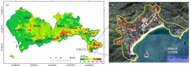
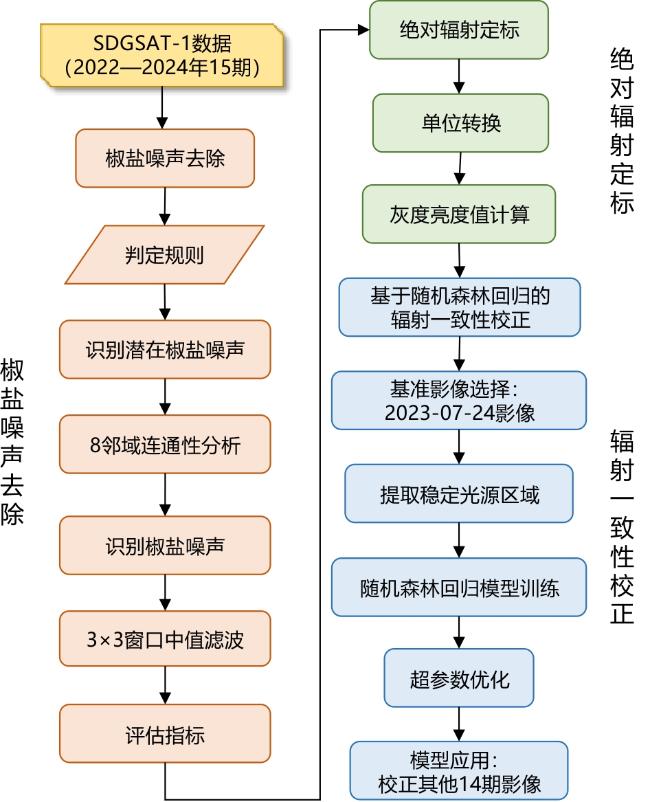
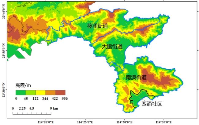
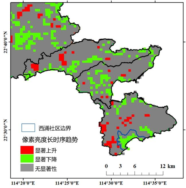
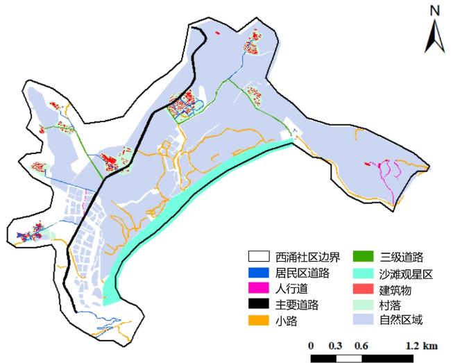
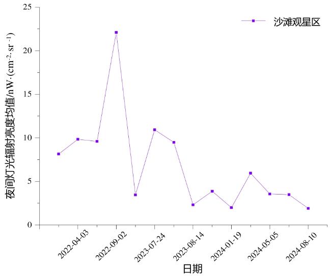
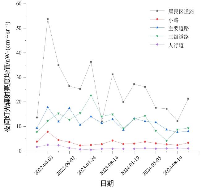
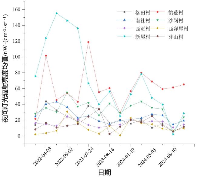
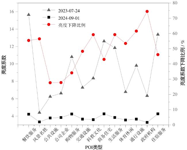
Rapid urbanization in China has significantly exacerbated light pollution, disrupted the ecological balance, and imposed constraints on both astronomical observations and public access to stargazing. Therefore, addressing light pollution has become a critical issue in ecological conservation and sustainable development. Shenzhen's Xichong Community achieved a landmark milestone in 2023 by becoming China's first International Dark Sky Community certified by the International Dark-Sky Association (IDA). This designation makes light pollution control practices of Xichong significant for similar regions. This study aimed to systematically evaluate the effectiveness of light pollution control measures in the Xichong Community, providing a scientific basis for balancing conservation and development in comparable areas. This study innovatively utilized high-resolution nighttime light (NTL) remote sensing data acquired using the Sustainable Development Goals Satellite-1 (SDGSAT-1), integrated with NASA's Black Marble products, to establish a refined monitoring and assessment framework for light pollution. To address the challenge of radiometric inconsistencies inherent to multitemporal SDGSAT-1 NTL imaging, this study proposed a novel radiometric consistency correction method based on Random Forest Regression (RFR). During the preprocessing phase, the images were subjected to salt-and-pepper noise removal and absolute radiometric calibration. Subsequently, the RFR model was applied to achieve a radiometric consistency correction. A comparative analysis with traditional linear brightness normalization confirmed the superior accuracy and effectiveness of RFR approach in enhancing image comparability. By leveraging corrected, high-quality, time-series NTL imagery, this study quantitatively assessed the effectiveness of light pollution control measures implemented in the Xichong Community over a three-year period. The key findings were as follows. (1) Significant reduction in light pollution: the Xichong Community exhibited a markedly greater decline in overall light pollution intensity compared to other areas within the Dapeng New District. Pixel-level analysis verified the widespread nature of this decreasing trend, with the brightness values showing a pervasive reduction. (2) Effective control across functional zones: the core stargazing beach area witnessed a substantial brightness reduction (57%) in September 2024 compared with that seen in September 2022. Road-lighting intensity also decreased significantly (56%-70%). Among the residential zones, Xinwu and Xiyangwei villages achieved reductions exceeding 69%, whereas brightness in Nanshe village decreased by 55.7%. Getian and Xigong villages experienced steady declines, while Hesou, Yashan, and Shagang Villages saw fluctuating but overall decreasing trends. (3) Effective management of light pollution sources: although accommodation facilities remain the primary contributors to light pollution, their brightness coefficients decreased significantly (46.11%). Points of Interest (POIs) related to tourism saw reductions exceeding 45% in brightness, with overall POI brightness coefficients declining by 27.68%-74.45%. These results demonstrate that the stringent lighting management policies implemented by the Xichong Community effectively mitigated the adverse impacts of tourism development on the dark sky environment. This study not only successfully applied high-resolution NTL data from SDGSAT-1, but also developed an RFR-based radiometric consistency correction technique, significantly improving the comparability of multi-temporal NTL data. The established methodological framework enables fine-scale monitoring of nighttime lighting at the community level, specifically for areas pursuing "dark-sky conservation + ecotourism" models. Furthermore, this study provides a foundation for establishing a dynamic monitoring and quantitative assessment system for light pollution within existing dark-sky reserves. These advancements offer critical scientific foundations and technical support for balancing the imperative of dark-sky conservation with sustainable tourism development goals.
Xi Li , Bubuli·Yeerleke , Jianchuan Zheng , Lin Mei . Evaluation of the Effectiveness of Light Pollution Control in Shenzhen Xichong Dark Sky Preserve Based on Nighttime Light Remote Sensing[J]. Tropical Geography, 2025 , 45(8) : 1373 -1387 . DOI: 10.13284/j.cnki.rddl.20250084
表1 SDGSAT-1夜光影像的成像日期及时间Table 1 Imaging dates and times of SDGSAT-1 nighttime light images |
| 影像日期 | 成像时间 |
|---|---|
| 2022-03-07 | T 21:46:49.13 |
| 2022-04-03 | T 21:42:13.13 |
| 2022-04-08 | T 21:48:11.78 |
| 2022-09-02 | T 21:44:35.70 |
| 2023-02-28 | T 21:51:27.68 |
| 2023-07-24 | T 21:39:17.99 |
| 2023-08-03 | T 21:39:17.99 |
| 2023-08-14 | T 21:48:58.94 |
| 2023-11-20 | T 21:39:28.95 |
| 2024-01-19 | T 21:37:41.13 |
| 2024-02-10 | T 21:43:40.85 |
| 2024-05-05 | T 21:42:40.03 |
| 2024-05-16 | T 21:41:9.92 |
| 2024-08-10 | T 21:35:59.09 |
| 2024-09-01 | T 21:33:14.03 |
表2 SDGSAT-1微光传感器绝对辐射定标系数Table 2 Absolute radiometric calibration coefficients of the SDGSAT-1 glimmer sensor |
| 波段 | Gain | Bias | 波段带宽(W)/nm |
|---|---|---|---|
| R | 0.000 013 54 | 0.000 013 675 4 | 294 |
| G | 0.000 005 07 | 0.000 006 084 | 106 |
| B | 0.000 009 925 3 | 0.000 009 925 3 | 102 |
表3 椒盐噪声去除结果Table 3 Results of salt-and-pepper noise denoising |
| 日期 | 残差噪声熵(RNE) | 平均相对偏差(MRD)/% | |||||
|---|---|---|---|---|---|---|---|
| 红波段 | 绿波段 | 蓝波段 | 红波段 | 绿波段 | 蓝波段 | ||
| 2022-03-07 | 0.465 3 | 0.241 0 | 0.468 3 | 1.59 | 1.72 | 2.74 | |
| 2022-04-03 | 0.128 3 | 0.132 5 | 0.060 3 | 0.81 | 0.85 | 0.34 | |
| 2022-04-08 | 0.749 1 | 0.364 1 | 0.626 3 | 2.31 | 1.73 | 2.32 | |
| 2022-09-02 | 0.199 2 | 0.136 2 | 0.024 0 | 1.30 | 0.86 | 0.12 | |
| 2023-02-28 | 0.416 4 | 0.569 5 | 0.544 0 | 1.19 | 2.59 | 2.42 | |
| 2023-07-24 | 0.316 4 | 0.264 3 | 0.396 1 | 1.61 | 2.17 | 1.10 | |
| 2023-08-03 | 0.252 6 | 0.173 3 | 0.213 8 | 1.73 | 1.15 | 1.47 | |
| 2023-08-14 | 0.248 3 | 0.499 5 | 0.627 0 | 1.73 | 1.94 | 1.27 | |
| 2023-011-20 | 0.142 5 | 0.212 4 | 0.063 6 | 0.90 | 1.45 | 0.37 | |
| 2024-01-19 | 0.345 5 | 0.343 7 | 0.363 5 | 1.54 | 2.54 | 2.72 | |
| 2024-02-10 | 0.171 3 | 0.283 6 | 0.155 3 | 1.13 | 1.03 | 1.01 | |
| 2024-05-05 | 0.294 0 | 0.742 3 | 0.460 4 | 1.11 | 2.28 | 2.63 | |
| 2024-05-16 | 0.087 3 | 0.668 7 | 0.281 5 | 0.53 | 1.51 | 1.03 | |
| 2024-08-10 | 0.342 0 | 0.813 4 | 0.258 0 | 1.52 | 1.92 | 1.84 | |
| 2024-09-01 | 0.107 4 | 0.426 7 | 0.508 2 | 0.66 | 1.26 | 1.09 | |
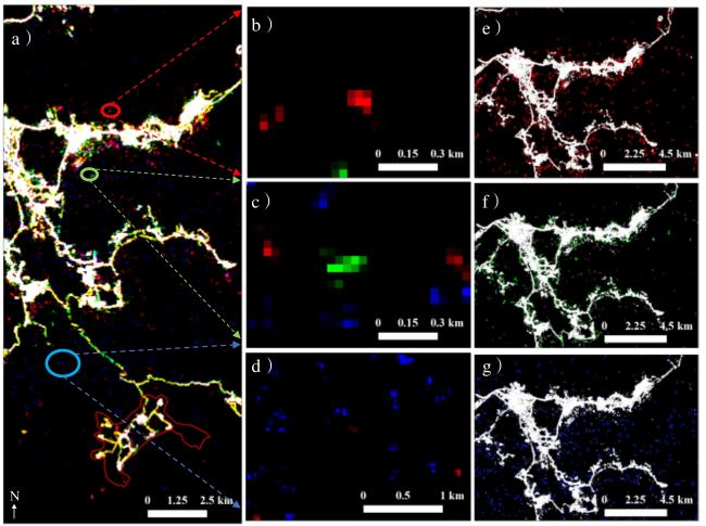
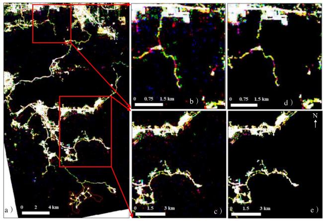
图5 2023-07-24 SDGSAT-1影像椒盐噪声去除效果对比(a. 原始影像;b和c分别为a图中方框区域的放大显示;d和e分别对应b和c区域经去噪处理后的结果)Fig.5 Comparison of salt-and-pepper noise removal effects in SDGSAT-1 imagery (July 24, 2023) (a. Original image; b and c show zoomed-in views of the boxed regions in a; d and e present the denoised results corresponding to b and c, respectively) |
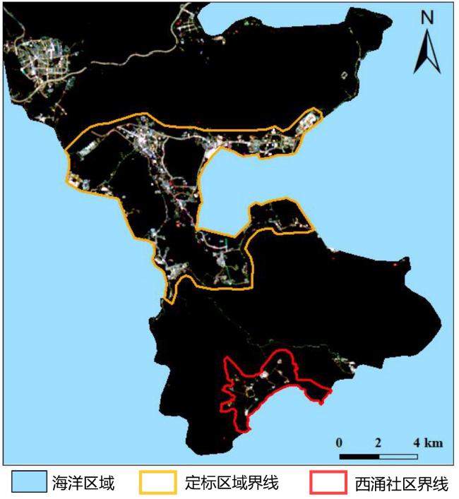
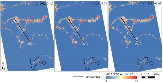
图6 经辐射一致性处理后的定标区域SDGSAT-1夜光遥感影像Fig.6 Radiometrically consistent SDGSAT-1 nighttime light imagery of stable light sources |
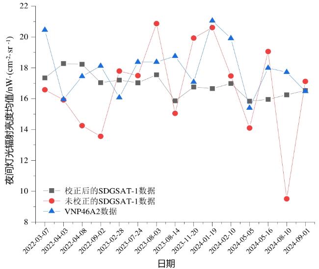
表4 VNP46A2数据与校正前后的SDGSAT-1数据之间的R²Table 4 R² values between VNP46A2 data and SDGSAT-1 data before and after correction |
| 影像日期 | SDGSAT-1数据 | 影像日期 | SDGSAT-1数据 | ||
|---|---|---|---|---|---|
| 校正前 | 校正后 | 校正前 | 校正后 | ||
| 2022-03-07 | 0.482 | 0.490 | 2023-11-20 | 0.363 | 0.381 |
| 2022-04-03 | 0.332 | 0.342 | 2024-01-19 | 0.462 | 0.475 |
| 2022-04-08 | 0.525 | 0.542 | 2024-02-10 | 0.393 | 0.414 |
| 2022-09-02 | 0.598 | 0.612 | 2024-05-05 | 0.472 | 0.479 |
| 2023-02-28 | 0.442 | 0.455 | 2024-05-16 | 0.385 | 0.403 |
| 2023-08-03 | 0.380 | 0.391 | 2024-08-10 | 0.482 | 0.536 |
| 2023-08-14 | 0.382 | 0.420 | 2024-09-01 | 0.564 | 0.578 |
表5 不同辐射一致性校正方法的RMSE与R²结果对比Table 5 Comparison of RMSE and R² Results from Different Radiometric Consistency Correction Methods |
| 影像日期 | 线性模型 | 随机森林回归法 | |||
|---|---|---|---|---|---|
| RMSE | R² | RMSE | R² | ||
| 2022-03-07 | 23.57 | 0.64 | 16.16 | 0.72 | |
| 2022-04-03 | 16.99 | 0.73 | 12.72 | 0.83 | |
| 2022-04-08 | 21.66 | 0.68 | 14.76 | 0.77 | |
| 2022-09-02 | 21.24 | 0.69 | 14.52 | 0.78 | |
| 2023-02-28 | 19.15 | 0.74 | 13.03 | 0.82 | |
| 2023-08-03 | 11.39 | 0.85 | 8.78 | 0.92 | |
| 2023-08-14 | 17.18 | 0.81 | 11.14 | 0.87 | |
| 2023-11-20 | 19.80 | 0.71 | 13.71 | 0.80 | |
| 2024-01-19 | 19.18 | 0.74 | 13.28 | 0.81 | |
| 2024-02-10 | 19.98 | 0.68 | 14.03 | 0.79 | |
| 2024-05-05 | 22.79 | 0.72 | 13.94 | 0.79 | |
| 2024-05-16 | 24.75 | 0.63 | 16.21 | 0.72 | |
| 2024-08-10 | 31.01 | 0.55 | 17.31 | 0.68 | |
| 2024-09-01 | 17.49 | 0.76 | 12.79 | 0.83 | |
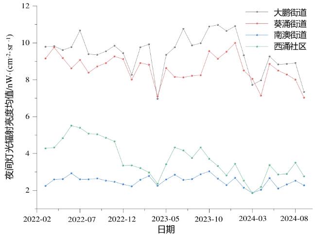
图10 大鹏新区各街道与西涌社区夜光均值时序变化(2022年3月—2024年9月)Fig.10 Mean nighttime light time-series for Dapeng subdistricts and Xichong (Mar 2022 - Sep 2024) |
表6 基于Theil-Sen和MK检验的大鹏新区夜间灯光变化趋势Table 6 Nighttime light change trends in Dapeng New District based on Theil-Sen slope and Mann-Kendall test |
| 区域 | Theil-Sen斜率 | 年变化率/% | MK_Tau | MK检验P值 | 趋势显著性 |
|---|---|---|---|---|---|
| 西涌社区 | -0.084 2 | -27.37 | -0.50 | 0.000 069 1 | 显著下降 |
| 南澳街道 | -0.004 64 | -2.23 | -0.16 | 0.21 | 下降(趋势不显著) |
| 大鹏街道 | -0.020 17 | -2.55 | -0.17 | 0.18 | 下降(趋势不显著) |
| 葵涌街道 | -0.033 42 | -4.65 | -0.30 | 0.018 | 显著下降 |
1 https://www.sdgsat.ac.cn
|
Biau G and Scornet E. 2016. A Random Forest Guided Tour. TEST, 25(2): 197-227.
|
|
Cao C, Shao X, and Uprety S. 2013. Detecting Light Outages After Severe Storms Using the S-NPP/VIIRS Day/Night Band Radiances. IEEE Geoscience and Remote Sensing Letters, 10(6): 1582-1586.
|
|
Chalkias C, Petrakis M, Psiloglou B, and Lianou M. 2006. Modelling of Light Pollution in Suburban Areas Using Remotely Sensed Imagery and GIS. Journal of Environmental Management, 79(1): 57-63.
|
|
Challéat S, Barré K, Laforge A, Lapostolle D, Franchomme M, Sirami C, Le Viol I, Milian J, and Kerbiriou C. 2021. Grasping Darkness: The Dark Ecological Network as a Social-Ecological Framework to Limit the Impacts of Light Pollution on Biodiversity. Ecology and Society, 26(1): 15.
|
|
Chang D, Wang Q, Yang J, and Xu W. 2022. Research on Road Extraction Method Based on Sustainable Development Goals Satellite-1 Nighttime Light Data. Remote Sensing, 14(23): 6015.
|
|
Chen F, Wang L, Wang N, Guo H, Chen C, Ye C, Dong Y, Liu T, and Yu B. 2024. Evaluation of Road Network Power Conservation Based on SDGSAT-1 Glimmer Imagery. Remote Sensing of Environment, 311: 114273.
|
|
Chen Y, He C, Guo W, Zheng S, and Wu B. 2023. Mapping Urban Functional Areas Using Multisource Remote Sensing Images and Open Big Data. IEEE Journal of Selected Topics in Applied Earth Observations and Remote Sensing, 16: 7919-7931.
|
|
Cheng B, Chen Z, Yu B, Li Q, Wang C, Li B, Wu B, Li Y, and Wu J. 2020. Automated Extraction of Street Lights from JL1-3B Nighttime Light Data and Assessment of Their Solar Energy Potential. IEEE Journal of Selected Topics in Applied Earth Observations and Remote Sensing, 13: 675-684.
|
|
Cinzano P, Falchi F, and Elvidge C D. 2001. The First World Atlas of the Artificial Night Sky Brightness. Monthly Notices of the Royal Astronomical Society, 328(3): 689-707.
|
|
Cole T A, Wanik D W, Molthan A L, Román M O, and Griffin R E. 2017. Synergistic Use of Nighttime Satellite Data, Electric Utility Infrastructure, and Ambient Population to Improve Power Outage Detections in Urban Areas. Remote Sensing, 9(3): 286.
|
|
Cynthia E P, Mohamad Samuri S B, Li W S, Ismanto E, Afriyanti L, and Arifandy M I. 2023. Improved Machine Learning Algorithm for Heart Disease Prediction Based on Hyperparameter Tuning. In: IEEE. 2023 IEEE International Conference on Artificial Intelligence in Engineering and Technology(IICAIET). Kota Kinabalu, Malaysia: IEEE, 176-181. DOI: 10.1109/IICAIET59451.2023.10291753.
|
|
Elvidge C D, Ziskin D, Baugh K E, Tuttle B T, Ghosh T, Pack D W, Erwin E H, and Zhizhin M. 2009. A Fifteen Year Record of Global Natural Gas Flaring Derived From Satellite Data. Energies, 2(3): 595-622.
|
|
Falchi F, Cinzano P, Duriscoe D, Kyba C C M, Elvidge C D, Baugh K, Portnov B A, Rybnikova N A, and Furgoni R. 2016. The New World Atlas of Artificial Night Sky Brightness. Science Advances, 2(6): e1600377.
|
|
Gillespie T W, Frankenberg E, Fung Chum K, and Thomas D. 2014. Night-Time Lights Time Series of Tsunami Damage, Recovery, and Economic Metrics in Sumatra, Indonesia. Remote Sensing Letters, 5(3): 286-294.
|
|
Grundland M and Dodgson N A. 2007. Decolorize: Fast, Contrast Enhancing, Color to Grayscale Conversion. Pattern Recognition, 40(11): 2891-2896.
|
|
Guk E and Levin N. 2020. Analyzing Spatial Variability in Night-Time Lights Using a High Spatial Resolution Color Jilin-1 Image - Jerusalem as a Case Study. ISPRS Journal of Photogrammetry and Remote Sensing, 163: 121-136.
|
|
Huang Y and Chen B. 2025. Nighttime Light Color Characteristics and Blue Light Exposure in China Based on SDGSAT-1 Glimmer Image. (2025-03-14) [2025-04-25]. https://doi.org/10.5194/egusphere-egu25-5560.
|
|
Jia M, Zeng H, Chen Z, Wang Z, Ren C, Mao D, Zhao C, Zhang R, and Wang Y. 2024. Nighttime Light in China's Coastal Zone: The Type Classification Approach Using SDGSAT-1 Glimmer Imager. Remote Sensing of Environment, 305: 114104.
|
|
Jiang W, He G, Long T, and Liu H. 2017. Ongoing Conflict Makes Yemen Dark: From the Perspective of Nighttime Light. Remote Sensing, 9(8): 798.
|
|
Katz Y and Levin N. 2016. Quantifying Urban Light Pollution—A Comparison Between Field Measurements and EROS-B Imagery. Remote Sensing of Environment, 177: 65-77.
|
|
Kuechly H U, Kyba C C M, Ruhtz T, Lindemann C, Wolter C, Fischer J, and Hölker F. 2012. Aerial Survey and Spatial Analysis of Sources of Light Pollution in Berlin, Germany. Remote Sensing of Environment, 126: 39-50.
|
|
Kyba C C M, Kuester T, Sánchez De Miguel A, Baugh K, Jechow A, Hölker F, Bennie J, Elvidge C D, Gaston K J, and Guanter L. 2017. Artificially Lit Surface of Earth at Night Increasing in Radiance and Extent. Science Advances, 3(11): e1701528.
|
|
李德仁,李熙. 2015. 论夜光遥感数据挖掘. 测绘学报,44(6):591.
Li Deren and Li Xi. 2015. An Overview on Data Mining of Nighttime Light Remote Sensing. Acta Geodaetica et Cartographica Sinica, 44(6): 591.
|
|
李熙,曹汉瑞,巩钰. 2023. 利用高分辨率夜光影像开展土叙地震灾害评估. 武汉大学学报(信息科学版),48(10):1697-1705.
Li Xi, Cao Hanrui, and Gong Yu. 2023. Turkey-Syria Earthquake Assessment Using High-Resolution Night-Time Light Images. Geomatics and Information Science of Wuhan University, 48(10): 1697-1705.
|
|
Levin N, Kyba C C M, Zhang Q, Sánchez de Miguel A, Román M O, Li X, Portnov B A, Molthan A L, Jechow A, Miller S D, Wang Z, Shrestha R M, and Elvidge C D. 2020. Remote Sensing of Night Lights: A Review and an Outlook for the Future. Remote Sensing of Environment, 237: 111443.
|
|
Li J, Xu Y, Cui W, Ji M, Su B, Wu Y, and Wang J. 2020. Investigation of Nighttime Light Pollution in Nanjing, China by Mapping Illuminance From Field Observations and Luojia 1-01 Imagery. Sustainability, 12(2): 681.
|
|
Li X, Chen F, and Chen X. 2013. Satellite-Observed Nighttime Light Variation as Evidence for Global Armed Conflicts. IEEE Journal of Selected Topics in Applied Earth Observations and Remote Sensing, 6(5): 2302-2315.
|
|
Li X and Li D. 2014. Can Night-Time Light Images Play a Role in Evaluating the Syrian Crisis? International Journal of Remote Sensing, 35(18): 6648-6661.
|
|
Li X, Li D, Xu H, and Wu C. 2017. Intercalibration Between DMSP/OLS and VIIRS Night-Time Light Images to Evaluate City Light Dynamics of Syria's Major Human Settlement During Syrian Civil War. International Journal of Remote Sensing, 38(21): 5934-5951.
|
|
Lin Z, Jiao W, Liu H, Long T, Liu Y, Wei S, He G, Portnov B A, Trop T, Liu M, Li X, and Wen C. 2023. Modelling the Public Perception of Urban Public Space Lighting Based on SDGSAT-1 Glimmer Imagery: A Case Study in Beijing, China. Sustainable Cities and Society, 88: 104272.
|
|
Liu S, Wang C, Chen Z, Li W, Zhang L, Wu B, Huang Y, Li Y, Ni J, Wu J, and Yu B. 2024. Efficacy of the SDGSAT-1 Glimmer Imagery in Measuring Sustainable Development Goal Indicators 7.1.1, 11.5.2, and Target 7.3. Remote Sensing of Environment, 305: 114079.
|
|
Liu X, Lu L, Guo H, Li Z, Li X, and Bilal M. 2025. Evaluating Fine-Scale Winter Nighttime PM2.5 Concentrations and Population Exposure Using SDGSAT-1 Glimmer Imagery. IEEE Journal of Selected Topics in Applied Earth Observations and Remote Sensing, 18: 1626-1637.
|
|
Liu Z, He C, Zhang Q, Huang Q, and Yang Y. 2012. Extracting the Dynamics of Urban Expansion in China Using DMSP-OLS Nighttime Light Data From 1992 to 2008. Landscape and Urban Planning, 106(1): 62-72.
|
|
Lv Z, Guo H, Zhang L, Liang D, Zhu Q, Liu X, Zhou H, Liu Y, Gou Y, Dou X, and Chen G. 2024. Urban Public Lighting Classification Method and Analysis of Energy and Environmental Effects Based on SDGSAT-1 Glimmer Imager Data. Applied Energy, 355: 122355.
|
|
Lyytimäki J. 2013. Nature's Nocturnal Services: Light Pollution as a Non-Recognised Challenge for Ecosystem Services Research and Management. Ecosystem Services, 3: e44-e48.
|
|
Ma T, Zhou Y, Zhou C, Haynie S, Pei T, and Xu T. 2015. Night-Time Light Derived Estimation of Spatio-Temporal Characteristics of Urbanization Dynamics Using DMSP/OLS Satellite Data. Remote Sensing of Environment, 158: 453-464.
|
|
Shi K, Chen Y, Yu B, Xu T, Yang C, Li L, Huang C, Chen Z, Liu R, and Wu J. 2016. Detecting Spatiotemporal Dynamics of Global Electric Power Consumption Using DMSP-OLS Nighttime Stable Light Data. Applied Energy, 184: 450-463.
|
|
唐倩迪,汪驰升,王永全,宿瑞博,江锦成,崔红星. 2020. 志愿者民航客机夜光遥感光污染监测初步研究. 遥感技术与应用,35(6):1360-1367.
Tang Qiandi, Wang Chisheng, Wang Yongquan, Su Borui, Jiang Jincheng, and Cui Hongxing. 2020. Preliminary Study on Light Pollution Monitoring based on Volunteered Passenger Aircraft Remote Sensing. Remote Sensing Technology and Application, 35(6): 1360-1367.
|
|
Wang N, Hu Y, Li X M, Kang C, and Yan L. 2023. AOD Derivation From SDGSAT-1/GLI Dataset in Mega-City Area. Remote Sensing, 15(5): 1343.
|
|
Wang T, Kaida N, and Kaida K. 2023. Effects of Outdoor Artificial Light at Night on Human Health and Behavior: A Literature Review. Environmental Pollution, 323: 121321.
|
|
Xiang W and Tan M. 2017. Changes in Light Pollution and the Causing Factors in China's Protected Areas, 1992-2012. Remote Sensing, 9(10): 1026.
|
|
余晓敏,邹勤. 2012. 多时相遥感影像辐射归一化方法综述. 测绘与空间地理信息,35(6):8-12.
Yu Xiaomin and Zou Qin. 2012. Methods of Radiometric Normalization for Multi-Temporal Remote Sensing Images: A Review. Geomatics & Spatial Information Technology, 35(6): 8-12.
|
|
Yi K, Tani H, Li Q, Zhang J, Guo M, Bao Y, Wang X, and Li J. 2014. Mapping and Evaluating the Urbanization Process in Northeast China Using DMSP/OLS Nighttime Light Data. Sensors, 14(2): 3207-3226.
|
|
Zhang D, Cheng B, Shi L, Gao J, Long T, Chen B, and Wang G. 2022. A Destriping Algorithm for SDGSAT-1 Nighttime Light Images Based on Anomaly Detection and Spectral Similarity Restoration. Remote Sensing, 14(21): 5544.
|
|
Zheng Z, Wu Z, Chen Y, Guo G, Cao Z, Yang Z, and Marinello F. 2021. Africa's Protected Areas Are Brightening at Night: A Long-Term Light Pollution Monitor Based on Nighttime Light Imagery. Global Environmental Change, 69: 102318.
|
|
Zhu Z, Zhou Y, Seto K C, Stokes E C, Deng C, Pickett S T A, and Taubenböck H. 2019. Understanding an Urbanizing Planet: Strategic Directions for Remote Sensing. Remote Sensing of Environment, 228: 164-182.
|
/
| 〈 |
|
〉 |