Unlike previous ecological restoration programs, the main focus of ecological restoration of national land space has changed from a single element in the natural ecology to the whole social-ecological system. The approach of this ecological restoration has changed from applying the pipe-end treatment to a single process to employing system restoration of the community of life consisting of mountains, rivers, forests, fields, lakes, and seas. Additionally, the aim has evolved from improving the health and stability of the ecological system to building a complex system in which humans and nature can coexist and develop a harmonious relationship. As the research on ecological restoration of national land space is developing a systemic and comprehensive view, it urgently requires support from multidisciplinary theories and methodologies. Ecological restoration planning of national land space at the provincial level is an action guide and programmatic document for provinces to further promote the construction of ecological civilization in this new era. This is a new but arduous and complex strategic task that allows extensive discussion on its research theories and methods. Accordingly, multidisciplinary theories and methods and participation from different parties and places are required. This study begins with the analysis of the scientific connotation and theoretical basis of ecological restoration planning of national land space, uses the man-land relationship theoretical framework as the guidance, integrates landscape ecology and nature-based solutions, and considers the local practice of ecological restoration planning of national land space in Guangdong Province. This paper presents the ideas and methods of provincial-level ecological restoration planning of national land space by focusing on the key points and difficulties, such as targets, indicators, major patterns, regional layout, and engineering systems. This is summarized as follows: the overall thinking of "six steps," the target system of "four dimensions," the zoning task of "three spaces," the spatial layout of "three levels," and the engineering system of "three scales." The study enriches the research on the method of ecological restoration planning of national land space by refining thoughts and methods and providing a reference for the ongoing ecological restoration planning of provincial-level national land space in China.
Territorial spatial planning is the optimization and adjustment of territories for modern countries in response to environmental changes in development. Since 2018, China has gradually established a territorial spatial planning system and has carried out the compilation of territorial spatial planning. In recent years, significant changes have taken place in the development environment—both domestically and abroad—illustrating the trends of shortened-chains and the regionalization of the global economy, intelligent and digital production and manufacturing, low-carbon and green social development, aging populations, and the presence of minority populations, all of which have a systematic and profound impact on China's economic and social development, as well as territory development and protection. Territorial spatial planning must be a response to the prevailing context timely. On one hand, China has a vast territory, a large population, obvious regional differences, and a huge market space. Therefore, it is necessary to build a new pattern of territory development and protection to coordinate both economic and social development and territory development, promote the matching between humans and nature, and improve the quality of economic development and people's quality of life. Territorial spatial planning should (1) support the "dual circulation" pattern with the domestic cycle as the main body and improve the efficiency of the national economy; (2) strengthen the comprehensive competitiveness and innovation capabilities of urban agglomerations and metropolitan areas to increase the carrying capacity of populations and industries; (3) build a new type of infrastructure that adapts to the new development concept; (4) and reconstruct the spatial patterns to respond to demographic changes. On the other hand, it is necessary to further improve the territorial spatial planning system, enhance the strategy of overall spatial planning, give full play to the professionalism of special planning, improve the humanistic nature of detailed planning, formulate and implement cross-regional spatial planning, improve the institutional mechanism of continuous spatial governance, and comprehensively improve the capacity of spatial governance and the modernization level of the governance system.
Through the establishment of the territorial spatial planning system, the logic of territorial spatial governance in the new era has gradually become clear, with ecological civilization construction as the strategic guidance, five development concepts(innovative, coordinated, green, open and shared development concept) as the ideological guidance, and territorial spatial planning as the basic tool. Based on the implications of territorial spatial and spatial planning, this study analyzed the internal value transmission relationship under territorial spatial governance and explored the logic of the general territorial spatial planning index system at the city and county scale required to meet high-quality development. Three main points regarding strategies to enhance territorial spatial planning were highlighted in this study. First, there is a strict internal transmission relationship between spatial planning goals and governance indicators. At present, territorial spatial governance for high-quality development faces complex problems. The government's multi-level strategic objectives and spatial governance concepts differentiate and evolve during the transmission, which leads to differences in the planning index system with respect to aspects such as attention, control, and overall planning. The guidance and control of planning implementation through planning indicators at all levels helps to achieve development goals and manage spatial issues. Second, the development of the index system for general territorial spatial planning at city and county scale requires not only the transmission of top-down hierarchical management and spatial governance for specific problems but also the exertion of index control based on constraints and expectations. Additionally, the index system also needs to consider the supporting role of new urbanization, rural revitalization, marine economy, ecological civilization, and other strategic objectives. Simultaneously, we should grasp the boundaries of developmental, regional, and spatial planning; carry out classified management around the territorial spatial using control objectives; and increase the proportion of spatial indicators in the index system. Third, the consensus on the planning index system in the era of multi-planning parallelism is to break down and reorganize. To build a planning index system for high-quality development, we need to recognize the strategic and fundamental roles of territorial spatial planning and respond to the incremental implementation of national strategies and improvement in the ability of territorial spatial governance. Under different resource endowments with different strategic development layouts and social and economic development stages, relying on the evolving logic of the index system will facilitate the development of a more practical planning index system with unified implications and provide support for the compilation, implementation, supervision, investigation, and evaluation of territorial spatial planning in the new era.
Territorial space planning in the new era is an important part of the spatial governance of China. At the city and county levels, the management of the relationship between urban and agricultural land is especially important to coordinate the protection and development of space and realize the harmonious coexistence between humans and nature. However, supporting data are still lacking. In the current territorial space planning system of China, the effective protection of urban agriculture and coordinated development with the urban regional system are being discussed. This study takes Shunde District of Foshan City as an example, relying on a 2020 research project concerning the characteristic culture and ecological landscape protection and development of Shunde District. The methods used included conference discussion, field survey, and interviews with villagers, village cadres, and entrepreneurs, and others. The research involved 17 villages, one aquaculture farm, one cultural and creative park, and one dike-pond system cultural leisure farm. Remote sensing (30 m resolution), land use change survey, and statistical and department data were used. Based on the analysis of the collaborative development mechanism of multi-functional reservoirs and land space, the production function, ecological function, and social function characteristics of the Shunde reservoir were assessed. The findings summarize the challenges faced by the current land space governance. The implementation strategy of the collaborative development of reservoirs and other land function spaces are discussed. The land spatial governance of Shunde is faced with problems of spatial fragmentation and nested distribution, aggravation of disaster and ecological risk, and the loss of cultural characteristics of Lingnan waterside villages. As an economic subsystem of the regional system, the foundation pond coordinates the functional coupling between this pond and different regional subsystems. The foundation pond also has a supporting and collaborative role in the regional system function, which is the basis to realize the coordinated development and sustainable utilization of land and space. Based on the production, and the social and ecological functions of reservoirs, the paper highlights land space governance strategies, including the implementation of reservoir function zoning governance, optimization of the main functions of key areas for coordinated development, protection of contiguous reservoirs and improvement of wetland ecosystem services, integration of reservoir cultural resources, creation of reservoir historical and cultural heritage path, promotion of regional cultural characteristics protection, and promotion of reservoir- and village-related industries. The collaborative governance of the park, functional optimization of the ponds near and at the center of the village, promotion of industrial upgrading, optimization of human settlements, and urban-rural integration are also highlighted. The results of this study enrich the research theory of reservoir systems and land space governance. The results also provide the basis for scientific decision-making of land space planning in the Guangdong-Hong Kong-Macao Greater Bay Area.
China is the advocator and builder of the thought of a community with a shared future for mankind. The international dissemination of its discourse requires more solid theoretical supporting research. Hence, the thought of a community with a shared future for mankind is China's intelligent contribution to the world and has been instrumental in solving major regional and global problems. Consequently, the Chinese academic community has the responsibility and obligation to convey the thought of a community with a shared future for mankind to the world in an understandable, objective, and authentic discourse. Further, it is responsible for continuously enhancing the scientific aspect and feasibility of the thought through academic achievements and excellence, thus establishing a leading research system. Currently, COVID-19 jeopardizes global public health security, including in political, economic, and social arenas. However, countries across the world are already in a state of close ties and destiny. Amid global public security incidents, the thought of a community with a shared future for mankind is connected by common interests, values, and responsibilities. Through the value resonance of its theoretical connotation, contacts and cooperation between countries are promptly promoted to form a close community of interests, health, destiny, and responsibilities to jointly respond to global crises and disasters. Therefore, amid the critical global fight against COVID-19, society urgently needs to forge an international consensus for fighting against this virus and maintaining global public health and safety with the thought of a community of a shared future for mankind. Accordingly, based on the perspectives of geopolitics and community, this paper first attempts to explore a theoretical analysis of the thought of a community with a shared future for mankind regarding scientific connotation, historical evolution, and contemporary values. Then, we examine specific cases to explain the practical applications of the thought of a community with a shared future for mankind in the fight against COVID-19 from the perspective of domestic practice, the Chinese program, and Western practice. Further, in doing so, we aim to demonstrate its dual value in spread and practice as well as its plight. Finally, we propose that governance and responsibility in the post-COVID-19 era, based on the thought of a community with a shared future for mankind, should be implemented by countries globally. Doing so involves playing a significant role in promoting global cooperation, maintaining world public health security, preventing a global recession, eliminating secondary disasters arising from COVID-19, transforming global governance, and reshaping international geopolitical relations. Therefore, this article may contribute to human society in fully and objectively understanding the thought of a community with a shared future for mankind, thus leading it to play a greater role in solving major global issues such as public health emergencies.
The COVID-19 epidemic spread globally at the start of 2020, resulting in a wide range of diffusion of infectious diseases. At present, SARS-CoV-2 is still prevalent worldwide, and it is of great practical significance to strengthen the study on the COVID-19 epidemic. Based on the COVID-19 confirmed cases and incidence, this article explored both the temporal and spatial distribution pattern of COVID-19 in Hunan Province and its influencing variables between January 21 and February 28, 2020 by using ArcGIS 10.3 and GeoDetector. The results show that: 1) The epidemic evolved with temporal phasing. The epidemic in Hunan Province can be divided into four basic stages: the diffusion period, peak period, decay period, and the stagnant period.The first COVID-19 confirmed case of 84.47% affected counties was imported from Wuhan;2) The epidemic spread as a result of transportation convenience. The confirmed COVID-19 cases were concentrated near major railway lines, which were also high-incidence areas. The epidemic occurred "early in prefecture-level cities and frequently in urban areas"; 3) the extent of the epidemic has distance attenuation. The COVID-19 cases and high-incidence areas were mainly distributed in the middle, north, and northeast of Hunan, in regions in proximity to Wuhan; 4) the epidemic was distributed with spatial aggregation. The agglomeration level of cases and incidences increased first and then remained high. The hot spots identified are in Changzhutan and Yueyang City, while the cold spots are in Xiangxi Prefecture; 5) the epidemic prevalence was of variable interaction. Wind-free, cold and dry weather was more conducive to the spread of the epidemic; population density, road network density and GDP were the main factors affecting the epidemic spatial differentiation; and the strongest variable interaction happened between natural and social factors. 6) the influencing variables of the COVID-19 epidemic have spatial heterogeneity. The impacts of spatial distance and population density have spatial heterogeneity on both the reported cases the total infections rates of COVID-19, spatial distance has the greatest impact in northeast Hunan, and population density has the greatest impact in northwest and northern Hunan; but the mobility of population and the number of health technicians only have spatial heterogeneity of impacts on the reported cases of COVID-19, the impact of population mobility is diminishing from north to south in Hunan, and the influence of the number of health technicians decreases gradually with the Changsha-Zhuzhou-Xiangtan city agglomeration as the core to the outer circle.The paper's conclusions are consistent with other scholars' studies in other regions, confirming that the epidemic not only spreads significantly in neighboring areas, but there are also "jump spreads" to distant cities that rely on the transportation network in Hunan. It is evident that restricting the entry of residents of affected areas plays a key role in COVID-19 prevention and control, and moreover, allocating plentiful health technicians, executing rigorous transport quarantine, and adopting compatible preventing measures with local and temporal conditions, are the top priorities in effectively responding to the impact of the COVID-19 epidemic.
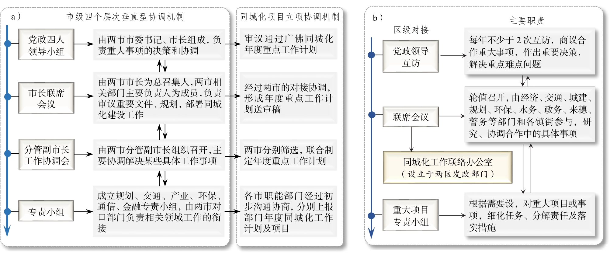
Under global economic competition, rescaling has become an important cross-border governance means to control the development of domestic space to attract capital flows and foster regional economic development momentum. City integration is a kind of urban regional scale, and its mechanism of cross-border governance has gradually become an important regional integration issue. At present, research on cross-border governance from the perspective of rescaling focuses on urban areas represented by urban agglomerations and metropolitan areas and new functional areas represented by state-level new areas, with limited research on the scale of city integration at the meso level. The discussion on the role and status of corresponding governance subjects, construction mechanisms, and incentive mechanisms needs to be enriched. In this paper, the evolution of cross-border governance is discussed from the perspective of rescaling, taking Guangfo city integration, which is relatively mature in the process of domestic city integration, as an example. The study finds that, taking the introduction of the outline of the reform and development plan for the Pearl River Delta region in 2008 and the outline of the development plan for the Guangdong-Hong Kong-Macao Greater Bay Area in 2019 as the target, the city integration process of Guangfo has experienced two stages of rescaling: from the governance scale of an "administrative area" to that of a "functional area" represented by the pilot zone for the high-quality development integration of Guangfo. By comparing and analyzing the cross-border governance mechanisms of city integration across different scales, this study finds that the city integration governance stage of the "functional area" scale, first, enriches the participation of multiple governance subjects, extending from "city-district-town" multi-level government to the functional platform management committee and platform joint venture company. Second, on the basis of the project implementation mechanism led by municipal departments, the construction mechanism strengthens the planning, construction, and operation mechanisms guided by functional areas and, taking the whole cycle as the concept, increases emphasis on integrated planning, construction, and operation. Third, the incentive mechanism has shifted from the driving of political instructions and economic benefits to the striving for policy and the sharing of institutional dividend. Both "administrative area" and "functional area" are the positive scales restructuring strategy of Guangfo to deal with the global competitive environment and respond to the requirements of national strategy. The two-stage cross-border governance mechanism is neither beneficial nor harmful, but is a choice to adapt to the different development stages of city integration. The governance mechanism of the "functional area" scale can be regarded as the experience retention and gradual reform of Guangfo's original governance mechanism, to improve the governance efficiency of the city integration and competitiveness. Guangfo's practice of using rescaling to promote cross-border governance reform and deepening in the last ten years can provide a certain reference for cross-border governance in the Guangdong-Hong Kong-Macao Greater Bay Area and other metropolitan areas in China. However, it should be pointed out that at present, the rescaling of the pilot area is more reflected in spatial planning and cooperation agreements, and has failed to produce a spatial governance subject that is fully integrated with the new scale. In addition, the deeper benefit sharing and risk responsibility sharing mechanism still needs to be strengthened.
Recreational fishery is one of the most popular outdoor activities in the United States. During its development, it has created huge economic and social benefits for the United States and formed a governance mechanism with polycentric participation. Based on the analysis of the current development of recreational fisheries in the United States, this study used the nearest neighbor index, buffer analysis, Tyson polygon and related dimension measurements to spatially analyze the distribution characteristics of recreational fishery resources in Florida. The results demonstrated that the recreational fisheries in the United States have formed a development pattern with fresh water as the mainstay and saltwater as the supplement. Among them, the recreational fishery resources in Florida are characterized by agglomeration and uneven distribution. More precisely, 80% of the recreational fishing sites are located within 20 km of the coastline and close to each other. In its long course of historical development, the United States has formed a flexible power operation mechanism, featuring decentralization and cooperation between the central government and local governments. Large areas scattered, small regional agglomeration spatial patterns have been used to adapt to the large area, and state governments, industry associations, and other bodies have created the main body participation of the polycentric governance mechanism to match the market characteristics of main body participation of the federal government. One of the purposes of polycentric governance is to improve management efficiency. The vast geographic area of the United States and the scattered pattern of large areas of recreational fishery resources increase the cost of management resource allocation and scheduling. Therefore, flexible, multi-level governance models are needed to improve governance effectiveness. Another goal of polycentric governance is to meet the distinctive needs of diverse audiences and provide diversified public services. The characteristics of the recreational fisheries market in the United States, where freshwater is the mainstay and saltwater is supplemented, and the distribution pattern of 'small areas gather, large areas disperse' require multiple governance entities to coordinate their overall development of recreational fisheries, while considering local development needs and characteristics. Accordingly, recreational fisheries in the region are developed to reduce the pressure on the local environment and improve the coordinated development capabilities of related industries. In view of this, this article addresses the problems of China's recreational fisheries and proposes to promote recreational fishery scientific management and high-quality development using a 'from bottom to top' polycentric governance mechanism, the establishment of a service-oriented government, the flexible empowerment of industry associations, and the integration and innovation of recreational fishery enterprises.
Land-use mix is regarded as an effective method to improve urban quality and optimize built-up areas. In urban studies, this theory is usually defined in terms of diversity. Methodological approaches rely heavily on diversity in land use, but they often fail to consider functional compatibility as another critical characteristic, thus providing only a partial picture of land-use patterns. Although quantitative frameworks of land-use mix are mature and comprehensive, methods to measure functional compatibility are seldom discussed. Thus, by reviewing the literature on functional compatibility measurements, this paper proposes three new indices to gauge the degree of compatibility between land uses based on the quantitative approaches of social segregation. After considering existing methodologies, the paper first focuses on all land-use types, including undeveloped land, in order to capture hidden incompatibility; second, it considers all possible geo-features and includes them in the measurement process; and third, it attempts to interpret the functional compatibility of blocks and parcels of land to provide a basis for the district-level planning at scale of a block of land. To provide empirical evidence, this paper uses Xiangtan city as a case study—a typical medium-sized city in China, and representative of other third-tier cities—to evaluate the proposed indices. The general findings suggest that, overall, current land-use compatibility in Xiangtan is relatively good, but there are still some incompatibilities between neighboring lands. Most of the land has been developed for industrial purposes in a suburban industrial park. Industries, especially Class II industries, often generate pollutants such as noise, wastewater, and air pollution that have a huge negative environmental impact on the surrounding areas. These impacts can be effectively minimized through zoning and planning schemes that restrict industries to allocated areas, such as industrial parks or industrial zones. However, this is not always possible, partly due to the imperfect process of land acquisition that invalidates the intended benefits of planning schemes. Over time, the cumulative effect of these compromised planning schemes is an absence of scientific land-use management and a fragmented, complex, and incompatible pattern in land use. Based on the block-level indices we developed, we created a map of bivariate scatter plots for strategy making to improve the land-use mix in Xiangtan city through spatial planning.
During the processes of stock land redevelopment, appropriate profit allocation is key to promoting the implementation of urban renewal. Meanwhile, its intricate, multi-participant interest games tends to obstruct the progress of urban renewal programs. Many scholars have studied the various types of interest conflicts among different stakeholders, their game models, and cooperation patterns of urban renewal. However, studies on how to effectively coordinate the diverse demands of multiple stakeholders and solve the problems of profit allocation management derived from the land value increments in different urban renewal stages are insufficient. By reviewing the development of Guangzhou urban renewal policies and their impact on the profit allocation pattern in practices during the past decades, this study clarifies the intrinsic interrelationships among the interests of local governments, investors, and original owners in urban renewal, as they struggle to maximize their benefit. Using Guangzhou urban village redevelopment as an example, this study summarizes the interest concerns and difficulties in urban renewal implementation in terms of value orientation, identification of rights and interests, and management system. Simultaneously, it proposes an innovated urban renewal implementation path of interest coordination based on public priority, profit sharing, co-planning, and co-management. In the coming reserve planning era, to progress urban renewal programs, not only the financial balance but also other comprehensive impact factors should be well-considered. Further studies on multi-dimension and whole-process implementation path of urban renewal in the field of interest coordination could make the planning decisions and working scheme more feasible, which promote urban regeneration.
The size of the elderly population in China has been increasing, and according to UN standards and relevant data, China has entered an aging society. With the aging of the population, residents' pension has become the focus of attention of the public and governments at all levels. Therefore, based on the life cycle theory, this paper considers the index and conversion coefficient of community coverage and elderly population coverage of pension service facilities in Hefei, Anhui Province. The problems existing in the spatial allocation of urban pension service facilities were also examined. This study developed the evaluation criteria for the rationality of spatial allocation of urban elderly service facilities in Hefei and analyzed their construction and spatial distribution characteristics by using GIS spatial methods, such as kernel density and network analysis. The rationality of spatial allocation was evaluated from three different spatial scales—cities, administrative regions, and streets—to provide a theoretical basis for the formulation of optimization measures. The results were as follows: 1) The supply of urban elderly care in Hefei is mainly based on community elderly care services, and the number and volume of care facilities are quite different among the four administrative regions. 2) The spatial distribution and configuration rationality of pension service facilities decrease from the urban center to the surrounding areas. The new urban area is weak in terms of pension service supply. The coverage rate of the elderly population in old urban areas is significantly higher than that in new areas. 3) The rationality of spatial allocation of urban pension service facilities is more significant at the street level, and the coverage of similar streets shows obvious spatial aggregation characteristics. Based on the residential area coverage rate of pension service facilities, this paper proposes the concept of elderly population coverage rate, and establishes the conversion coefficient between the two, which is the innovation of the research method adopted in this study. In addition, the rationality evaluation standard of spatial allocation of pension service facilities is constructed, providing a basis for rationality evaluation analysis. Through a comparative study of different spatial levels of cities, administrative districts, and streets, it was found that the evaluation of spatial allocation rationality of pension service facilities is closely related to the spatial scale: the smaller the spatial scale, the more accurate the evaluation. The results of this study could be useful for relevant research on other similar cities. Further, this study has practical significance for the allocation and layout of urban elderly service facilities. In other words, in the process of constructing the life cycle, the spatial distribution characteristics of service objects should be fully considered in the allocation of public service facilities, and attempts should be made to achieve a high spatial matching between "people" and "facilities".
Studies of historical climate and environment changes in the eastern monsoonal region of China have made great progress in recent years. However, progressively studies indicate that the processes of climate and environment changes during the last 2000 years differed greatly in different regions. This is especially the case among studies based only on single-site records, possibly because of different materials, proxy indicators, dating accuracy, etc. Therefore, it is necessary to conduct comprehensive and integrated analyses of regional climate and environment changes at larger spatial scales. Here, multiple climate proxy records selected from 16 sites in southeastern China (i.e., approximately east of 105° E and south of 30° N) were used to synthesize and reconstruct the temperature and precipitation changes over the past 2000 years, and the possible forcing mechanisms behind these changes were explored. The results indicate that the integrated temperature sequence in the study region is quite comparable to the reconstructions for the entirety of China, eastern China, and the Northern Hemisphere. Several typical characteristic climate periods on centennial timescales, such as the Dark Age Cold Period, the Medieval Warm Period, the Little Ice Age, and the modern warm period of the 20th century, were well revealed in the present reconstruction. The integrated precipitation sequence shows that the dry and wet phases in southeastern China have changed significantly during the past 2000 years. Specifically, precipitation was relatively higher during the Medieval Warm Period, but it was relatively lower during the Little Ice Age (i.e., less precipitation occurred in the former part of the Little Ice Age and more precipitation occurred during the latter part). In general, the synthesized temperature and precipitation changes in southeastern China had relatively diverse hydrothermal combinations during the last 2000 years. However, it is noteworthy that the integrated precipitation sequence in southeastern China is weakly comparable to the sequence in northern China, reflecting great regional differences in historical precipitation changes. Thus, the forcing mechanisms might differ greatly from south to north in the monsoonal region of eastern China. Furthermore, the results suggest that large-scale atmosphere–ocean interactions, volcanic activities, and changes in solar radiation could have had significant effects on the climate and environment changes in southeastern China during the last 2000 years.
Prehistoric human cultural sites along the eastern coast of Fujian Province are important records for studying the origin and spread of the Austronesian civilization. The Huangqiyu site is the first Tanshishan culture site to be unearthed in the Min River estuary area and was excavated by scientific archeology. It has great significance for further research of the Tanshishan culture and the coupled relationship between prehistoric human activities and environmental changes in the Fujian coastal region. The chronology of archeological sites is an important foundation for prehistoric archeology. In this study, the burial age of the Huangqiyu site in Lianjiang County was analyzed using the Optically Stimulated Luminescence (OSL) dating technique on the basis of Accelerator Mass Spectrometry (AMS) 14C dating. In the field, the T2 section of the Huangqiyu site was selected for sampling, and the single-aliquot regeneration dose method of medium-grained quartz was used to assess OSL chronology in the laboratory. The results showed that the OSL burial age of the Huangqiyu site ranges from approximately 8.5 ± 0.5 to 4.4 ± 0.2 ka, corresponding to the sedimentary/cultural strata of the early Middle Holocene. The OSL age of sample 2019118, which was consistent with the AMS 14C age, was 4.4 ± 0.2 ka, corresponding roughly to the Tanshishan culture. The age of sample 2019117 was 5.4 ± 0.3 ka, which may be an overestimation because the equivalent dose of this sample showed a weakly skewed distribution with a tail at the high value end, indicating that there was a small amount of sundry particles and that the drying was insufficient. This problem may have led to a bias in the measured equivalent dose and, in turn, to overestimation of the age of the sample. The age of sample 2019119, which was affected by the sampling environment, was 8.5 ± 0.5 ka, possibly indicating the maximum age of the bottom boundary of the site. Archeological studies have found that the age indicated by the pottery features excavated from the cultural layer at the bottom of the Huangqiyu site is most likely earlier than the Tanshishan culture, or possibly that of the lower strata of the Tanshishan culture. Overall, the ages of samples 2019117 and 2019119 are different from the AMS 14C ages, but these are consistent with the archeological characteristics of the site. By comparing the geomorphological and environmental evolution process of the Fuzhou Basin, where the Huangqiyu site is located, with the regional prehistoric human activities, it was found that the site corresponds to the warm climate of 6 500-4 000 a B P and relatively a high sea level period. Many prehistoric remains were developed in the Fuzhou Basin during this period, and the prosperous Tanshishan culture and the lower Tanshishan culture emerged in the region. At the end of the Neolithic age, the abrupt cold event of 4.2-4.0 ka, the drastic change of climate and environment in the tropical and subtropical regions on both sides of the Pacific Ocean at 4 000-3 000 a B P, and the invasion of the northern Wu-Yue culture may explain the disappearance of the follow-up culture. Because of the limited precision of the regional sea-level change curve, it is insufficient to discuss sea-land change and the coupled relationship with human activities. Relevant studies need to strengthen these aspects in the future.
Sinkholes are common geohazards in karst areas and often cause life and economic losses. Karst collapses are random, fuzzy, sudden, and concealed owing to the randomness of karst cave and karst channel development. On December 19, 2008, five karst collapses and one land subsidence occurred in Xiamao village. The center of this karst collapse is the Northwest street of Xiamao village and Huafu street of Shayuanfang, Baiyun District, Guangzhou (23°13′40″ N, 113°14′47″ E). Karst collapses cause wall cracking, building inclination, and subsidence of ground foundation, with a depth of 2-4 m. In August 2015, a karst collapse was induced by drilling of a bored pile at a residential building construction site. Sinkhole hazards in Xiamao village have greatly affected the safety and life of residents. To prevent karst collapses, it is important to investigate the formation mechanism of the sinkholes. Based on the geological exploration of the aforementioned karst collapse in Xiamao village, Guangzhou, we discuss the local geological environment conditions and characteristics of karst development, and causes of karst collapse. The results show that the soluble rocks in and around Xiamao village are Carboniferous Hutian Formation limestone (C2ht) and Permian Qixia Formation marl and carbonaceous marl (P2q), hence the frequent karst collapses in the area. The Quaternary overburden in the area is thick and unevenly distributed, with several soil caves at the bottom, and the concealed soluble rock has high water content and is rich in karst caves, providing a good geological environment background for karst collapse. Furthermore, there is a close hydraulic connection between the pore water in the overburden soil and the water in the underlying limestone fractured caves. The change of the groundwater level in the water-bearing sand layer directly causes the water level of the underlying limestone fractured cave water to fluctuate, thus enabling the hydrodynamic factors of karst collapse. During the construction of the aforementioned bored pile, the borehole penetrated the soil cover on the top of the soil cave in the overburden, causing the fine sand and silt on the upper part of the cover to flow into the soil cave, triggering karst collapse. Therefore, establishing a long-term monitoring network of groundwater dynamics in karst distribution areas and grouting the karst-collapsed areas are effective ways for remediation of karst collapse in Xiamao village. Additionally, we can provide technical support to the local government in implementing karst collapse prevention measures in urban planning and construction.
In order to manage the impact of drastic changes in the domestic and international economic environment and seek ways and paths to improve the innovation capabilities of local traditional manufacturing clusters, based on the perspective of evolutionary economic geography, this research examines the Xintang jeans garment manufacturing cluster in Guangzhou, obtaining first-hand data from questionnaires and in-depth interviews. We constructed an innovative support and environmental network structure model, proposed an analysis framework for network evolution, and conducted an empirical study on the evolution process, characteristics, and motivations of the innovation network of the Xintang jeans garment manufacturing cluster. The research results show that: (1) The innovation network of the Xintang jeans garment manufacturing cluster has experienced four stages that include budding (1980-1990), networking (1990-2000), growth (2000-2012), and development (2012-2018). In the budding stage, the production and innovation links between enterprises began to appear, and the cluster innovation network was initially established. In the networking stage, the derivation of firms deepened the informal connections between enterprises, and the innovative core network steadily developed. In the growth stage, the adjustment of policy and planning positioning reshaped the industrial development strategy, the innovation connection was strengthened, and the innovation network scale was expanded. In the development stage, the cooperation between the government, universities, research institutions, and enterprises was strengthened. The technological innovation capabilities of leading companies in jeans garment production have been improved, the innovation of online and offline business models has been highlighted, and the scale of innovation networks has been stable. (2) Different sub-networks play different roles in promoting the evolution of the overall network. In the budding stage, the innovation environment sub-network directly induced the formation of the overall innovation network. In the networking stage, the innovation environment network and the innovation core network jointly promoted the further development of the overall innovation network. In the growth stage, the innovation support network was the main factor that accelerated the growth of the overall innovation network. In the development stage, the innovation environment network once again became the key to the evolution of the overall innovation network. (3)From the perspective of evolutionary power, endogenous and exogenous power have jointly promoted the development of innovation networks. The export-oriented economic characteristics of the cluster induced the initial network to be dominated by global forces; it then expanded domestically after forming a local scale. The core network, support network, and environment network are important components of the overall innovation network. These three sub-networks are causal and interact with each other to jointly promote the coevolution of the overall network. This research focuses on the innovation and development of traditional manufacturing clusters such as jeans garment manufacturing and is a useful supplement to Chinese research on traditional industry cluster innovation networks.
In recent years,as an important means for the development of the stadium industry supported by Internet technology, building complex commercial complexes with the help of virtual network platforms around the stadium service as the core industry has become a popular trend in some cities in Chine.The academic circle has paid little attention to research on the abovementioned field, but exploring the integration of the online and offline chains of industrial clusters from the perspective of geographical space can be very fruitful, providing a theoretical reference for discussing the construction of virtual clusters of stadiums.The starting point of this research is based on the development status of the comprehensive penetration of Internet technology into the industrial field. Some scholars hypothesize that"cyberspace proximity will replace geospatial proximity,"while others insist that network information technology and platform are the"catalysts"for the transformation and upgradation of offline industries;at the same time, it focuses on the geographical factors affecting the offline entity industry itself and its related industries, which is of great significance to the construction and development of the online virtual platform.Accordingly, this article explains the construction of virtual clusters of stadiums from the perspective of geographic space.It then analyzes the reasons why the geographical clustering effect of stadiums cannot be formed.By summarizing the role of industrial virtual clusters in promoting industrial aggregation, strengthening scale economy effect, improving relationship between division of labor and cooperation, driving cooperation and competition atmosphere, forming flexible innovation mode,etc. it is proposed that the construction of virtual clusters is one of the most important forms of sports stadium industry development in the future.At present, the virtual cluster of sports stadium industry in China is the value chain of cooperation and competition among members in the horizontal direction, and the value chain of production and sales at both ends of supply and demand in the vertical direction, which together constitute the basic structural system of the cluster;according to the main industry scale, geographical location, property right attribute, network degree,etc., virtual stadium industry cluster can be divided into haplotype, chain type, and alliance type, and according to its structural system and functional characteristics, its development process needs to go through three upgrading stages:technology integration, product transformation, and structure optimization.Finally, it is recommended to gain an understanding of the geographical significance of the virtual cluster construction of stadiums, continue to improve the core competitiveness of offline stadium services, fully utilize the government's policy support and lead the role of alliances, establish a supervision mechanism of virtual industry cluster member access, etc., for the innovation and development of virtual industry cluster theory and the practice guidance.
As a typical land element, buildings play a dominant role in land use, urban planning, and disaster risk assessment, which is an important goal of remote-sensing-based surveying and mapping. Presently, with the rapid development of island economies, it is particularly important to extract island buildings accurately to avoid disorderly expansion. Machine learning is a common method for extracting terrain objects from high-resolution remote sensing images. However, the remote sensing features of buildings are complex: traditional machine learning methods suffer from poor robustness and have difficulty in fully mining deep-seated features. The overall accuracy and Mean Intersection over Union (mIoU) score of the deep learning architecture DeepLabv3plus is higher than those of other semantic segmentation models, making it suitable for remote sensing building extraction. In this study, the DeepLabv3plus segmentation architecture is adapted, based on the Xception network and hole convolution, to reduce the large number of pictures (batch size) and video memory required to train a deep learning model. Group Normalization (GN) is used to replace the original Batch Normalization (BN), to improve the feature extraction accuracy for a small batch size. Compared with the original DeepLabv3plus architecture, the DeepLabv3plus-G method can train models with a smaller batch size under limited Video Graphics Array (VGA) memory, and the segmentation accuracy is improved. DeepLabv3plus-G can effectively extract island buildings, which provides a new method for Chinese island construction supervision. As a result of limited island building data, this study designs an intelligent collection of pre-training sets and an annotation method based on multi-source data of domestic urban building datasets. Transfer learning strategy is also adopted to train the network model on the automatically annotated domestic urban building datasets. The final pre-training model was saved in the form of a network architecture and weights. The model size was 158 MB, the number of parameters was 22910480, and the depth was 65 layers. Remote sensing images of buildings from 29 temperate islands (including Chrysanthemum Island, etc.), 48 subtropical islands (including Chongming Island, etc.), and six tropical islands (including Haidian Island) in China from Google Earth, with a spatial resolution of 0.6 m, were employed. After automatic clipping, 891 images of island buildings with dimensions of 512 × 512 pixels were obtained. The open source labeling software Labelme was used for manual labeling before the algorithm experiments. Results showed that both the mIoU and mean Average Precision (mAP) of DeepLav3plus-Gare improved under the same batch size, compared to traditional methods. When the batch size was two, the mIoU and mAP improved by 8.95% and 10.45%, respectively, compared to the scores for the DeepLabv3plus architecture. Under the same network, the accuracy of DeepLabv3plus pixel segmentation improved with increasing patch size. The mIoU and mAP scores for a model with a batch size of eight were 10.51% and 10.26% higher than those of models with a batch size of two, respectively. However, the mAP of DeepLabv3plus-G pixel segmentation hardly changed with an increase in the batch size. In conclusion, when the batch size is small, the mAP and mIoU of the DeepLabv3plus building classification algorithm based on GN increase, and more accurate pixel-level island building extraction results are obtained.
Precipitation is a vital physical parameter of the earth surface system, and accurate estimation of spatiotemporal patterns of precipitation is essential for flood disaster monitoring, drought monitoring, and water management. However, regional precipitation, which is derived solely from rain gauges, remote sensing, and weather radar, is subject to large uncertainties, especially for topographically complex mountain areas. Multi-source precipitation data fusion is a practical method for achieving high-accuracy and high-resolution precipitation information. This study proposes an XGBoost-based geostatistical fusion method (XGBoost) for combining information from ground-based measurements, radar precipitation, and other auxiliary parameters, to improve the accuracy of the spatiotemporal distribution of precipitation in geographically complex mountain areas. In the XGBoost-based geostatistical fusion model, radar precipitation and terrestrial parameters, which include longitude, latitude, digital elevation model data, aspect, slope, enhanced vegetation index, and distance from the coastline, are considered as the independent variables. The XGBoost-based geostatistical fusion model was applied to a regional rainstorm event that lasted from August 26th to 30th, 2018, in northern Guangdong using daily measurements from 206 rain gauges and 51 stations for model training and validation. The fused results were further compared with the results obtained from the multiple linear regression kriging method (LM). Validation using ground-based precipitation measurements was applied for different data fusion methods based on the coefficient of determination (R2), Mean Absolute Error (MAE), and Root-Mean-Square Error (RMSE). The experimental results indicated that: (1) The ground-based precipitation data were positively associated with radar precipitation, and the correlation coefficient between the ground-based precipitation data and the terrestrial parameters varied significantly with measurement time over the regional rainstorm event. (2) The XGBoost produced 1 km precipitation prediction with higher accuracy than the LM before residual correction. (3) The accuracy of fused precipitation with the XGBoost-based geostatistical method was reduced after residual correction, but the accuracy of the LM was increased. The XGBoost-based geostatistical method produced 1-km precipitation with lower accuracy than the TsHARP utility on August 27th and 29th; however, in general, the XGBoost-based geostatistical method outperformed the LM because the nonlinear relationships between the ground-based precipitation data and the independent variables were considered in XGBoost. (4) The XGBoost-based geostatistical method captured the differences in precipitation for different land cover patterns and produced the spatial details of fused precipitation over the complex mountain areas.
With the emergence of new economic centers around the world, the practice of immigration has gradually moved beyond the traditional dualistic model of "Destination to departure" and been replaced by temporary, short-term settlement. In order to explore the social adaptation strategies of "migratory migrants," this paper expounds the influencing factors of migrants' social integration in a micro-social context. This paper focuses on the phenomenon of "staggered time" among African Americans in Dengfeng village, which was found in the process of investigation. From February to April in 2019, the authors conducted a questionnaire survey and in-depth interviews regarding the phenomenon. Using the measurement sentence system, this study measured and analyzed the phenomenon from the three aspects of cognition, emotion, and behavior, focusing on identity and social integration. After the preliminary conclusion that "staggered time is actually a kind of social division," the score of the measurement sentence system was taken to measure the "degree of division" of African individuals and as the independent variable; the social characteristics of population, social status, duration in Guangzhou, and attitude toward the community were taken as dependent variables. The results of correlation regression analysis show that this kind of social adaptation strategy is closely related to a group's social status, duration in Guangzhou, and attitude toward the community. The essence of this strategy is the specific means of the "shallow integration, deep differentiation" social adaptation strategy, as well as the interactive result of the response of other community groups. Through the strategy of "staggered time," Africans selectively yield part of the demand to occupy, use, and transform the community and realize active separation; in this regard, other groups in Dengfeng Village adjust their own behavior patterns according to the needs of interactions with Africans so as to achieve two-way adaptation among different groups. This paper tentatively puts forth a partition strategy of Africans based on the time dimension, which has a certain reference significance for the future development of urban management and resource allocation in time-related policies.
TAbstract: The rapid development of the economy and society and the coordinated advancement of industrialization and urbanization have led to the intensification of the man-land contradiction. It requires the use of spatial multi-functionality to maximize the value of regional space, promote the diversification of social needs, and help rural areas meet multi-functional needs. Correct identification of rural regional functions is an important way to implement the strategy of rural revitalization and comprehensively deepen rural reform. Taking Sichuan Province as the research subject, we constructed a multi-functional evaluation index system for rural areas from four perspectives, that is, economic development, food production, social security, and ecological protection. We used the comprehensive evaluation method to investigate the spatial distribution characteristics of various functions, and the vertical and horizontal comparison method to identify the dominant function and short board function, and the regional types were divided accordingly. In cognizance of the five major economic zones in Sichuan Province, this paper puts forward corresponding rural revitalization paths of various regional types to provide a benchmark for the implementation of a rural revitalization strategy in Sichuan Province. A clear spatial pattern differentiation of the rural regional function in Sichuan Province was noted. The regional characteristics of the economic development function and the social security function are the same, showing a gradual weakening differentiation pattern from southeast to northwest Sichuan. The spatial agglomeration characteristics of the grain production function in the Chengdu Plain Economic Zone and the Anning River Basin in Panxi are obvious, and the ecological conservation function is gradually enhanced from southeast to northwest Sichuan. Via the identification of the dominant function and the short board function, we divided Sichuan Province into three categories: dominant development type, polarization development type, and comprehensive development type. Among them, the dominant development type and the polarization development type were divided into nine sub-categories according to their characteristics. The specific implementation paths of rural revitalization are proposed according to different regional types, in which the dominant development type gives priority to playing the dominant function while integrating and coordinating other functions to promote comprehensive rural revitalization development. While giving full play to its advantages, the polarization development type complements the shortcomings and achieves basic balanced development. Based on the existing foundation, the comprehensive development model realizes industrial upgrading and becomes the leading means of demonstration of rural revitalization and development in Sichuan Province. The main contribution of this paper is therefore the consolidation of the convergence of poverty alleviation and rural revitalization. The dominant function and short board function are used to classify the regional functions of rural areas in Sichuan Province. The division results are consistent with the regional differentiation of nature and economy in Sichuan Province from different perspectives. The development path of rural revitalization provided decision-making reference for this regional type.