
Farmer' livelihoods are an important issue for rural revitalization and rural sustainable development. It has been proven in recent years that rural tourism influences farmers' livelihoods and its impacts vary based on different tourism development modes. The DFID sustainable livelihoods framework has been widely used in research on rural tourism development and farmer' livelihoods. It offers a comprehensive perspective that links elements from the external livelihood environment, to investigate farmer' livelihoods. This study developed an evaluation index for farmer' livelihood capital based on the DFID sustainable livelihoods framework. The evaluation index was used to analyze the farmer' livelihood capital. Azheke village, Yunnan Province was chosen as an example in the present study, which successfully launched a tourism poverty reduction program, the "Azheke Plan", in 2018. The data used in this study were collected through questionnaire survey from July 2020 to February 2021, during which the first author lived in Azheke Village. The findings of this study were summarized as follows: (1) Farmers in Azheke used to have only one livelihood mode: farming or working in cities. Now rural tourism development has allowed local villagers to work within local tourism businesses or operate their own tourism businesses in the village. thus, farmers has formed a diversified livelihood mode. (2) Families with different livelihood modes have manifested different features and livelihood capital. Ranking from high to low, the livelihood modes are: tourism-oriented, tourism involved + working in cities, tourism-involved, working in cities, and farming + working in cities. The sequence highly correlates with the degree of farmer' participation in tourism. (3) Farmers whose livelihoods are tourism-oriented, tourism involved + working in cities and tourism-involved have the highest degree of participation in tourism, their household labor and livelihood capacity has improved, it have created more livelihood outcomes for their households, and has a higher level of livelihood capital. Farmers who work in cities and farming + working in cities experienced the growth of physical capital and financial capital mainly throughout the "Azheke Plan", but their livelihood capital is lower than the other three livelihood modes relating to tourism. (4) From the institution perspective, this study explores the relationship between tourism development and changes in livelihood. Several notes are summarized on villagers' livelihoods through "Azheke Plan" from basic conditions, external support, internal factors, livelihood strategies and livelihood results. Finally, the future research direction of tourism development and farmer' livelihood, as well as the possibility of replicating the "Azheke plan" in other regions are discussed.

Since the 18th and 19th National Congress, China has put forward ecological civilization construction and rural resolution, requiring the transformation of traditional agricultural production models to a high quality, sustainable, green ecological production model. As an eco-environmental, sustainable, and high value-added agricultural production model, organic agriculture is in-line with the future development direction of China's rural areas and policy guidelines and is also a useful alternative model to traditional agriculture. In order to promote the development of the organic livestock industry in China, this study analyzed the service function and production function basic data of 744 organic livestock enterprises and explored the factors of functional location using Pearson's correlation analysis and multi-regression analysis methods. There is substantial research available related to the functional location of the organic livestock industry that can provide a certain reference value for the location analysis of different industries. The multi-scale analysis of different functional locations can provide reference and policy recommendations for the functional location layout of organic livestock enterprises in China. The results of this study showed the spatial agglomeration characteristics of organized livestock enterprise service and production function locations, such as central and eastern Inner Mongolia, northwestern Xinjiang, northeast Sichuan, and southern Anhui. There is a strong cohesion phenomenon among the organic livestock enterprise service and production function locations in China. However, this is limited to the development characteristics and affected zone, as different functional structures of some organic livestock enterprises have not occurred in the production expansion process. The production and service function locations of organic livestock enterprises are affected by multiple influencing factors, such as feed output, environmental quality, and policy benefits, of which natural resources and the development level of the traditional livestock industry have the greatest impact. It is also important to note that the location layout of organic livestock enterprises has deeper contacts with feed resources and environmental quality at the macro level. The influencing factors of organic livestock enterprise service and production function locations are consistent, but the same influencing factor has certain differences in the extent of their service and production function locations. According to the demand, organic livestock enterprises should guide different functional departments to lay out the functional location gathering area and balance the needs of the service and production function sectors in the initial development phase, select resource endowment, rich in knowledge and technology, convenient transportation, cheap land prices, and low labor cost-effective suburban areas. Local governments should increase policy support and guide deployment in areas with rich natural resources and developed traditional livestock industries. Moreover, according to actual conditions, they should guide enterprises to convert production from traditional to organic in the traditional livestock production industry.
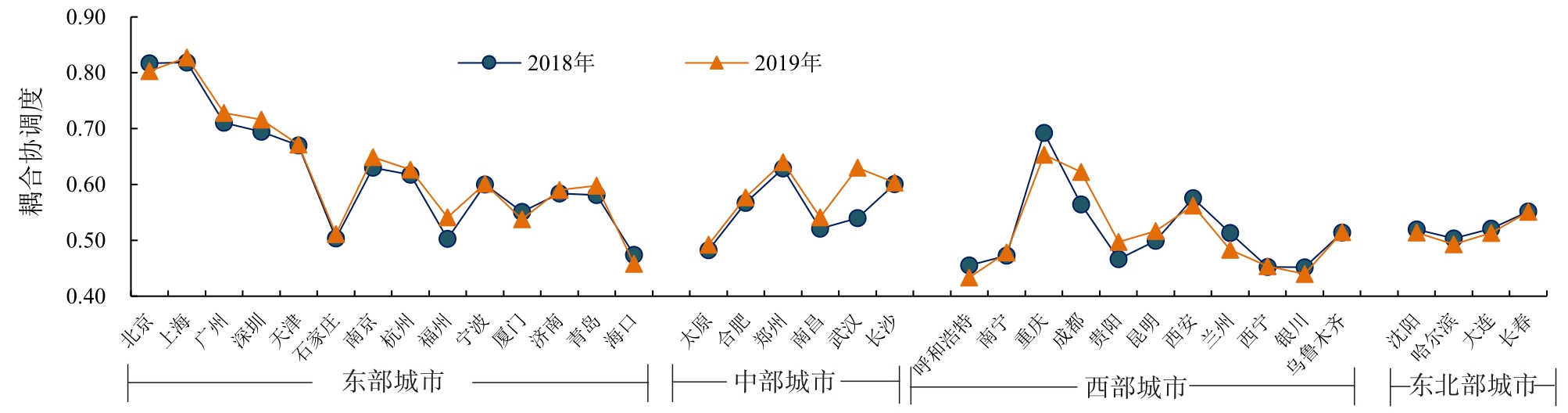
With urbanization, the influx of populations into economically developed large- and medium-sized cities, and the reality of high property prices are forcing the rental housing market to expand. The population, economy, and housing rental market interact, and the coordinated development of the three systems is an inevitable requirement for sustainable urban development. To coordinate the relationship between population, economy, and the housing rental market in large and medium-sized cities, it is crucial to solve the housing problem and achieving "housing for all so that everyone can live and work happily". Based on coupling coordination and spatial error models, this study explores the level of coupling coordination of the population-economy-housing rental market system in thirty-five large and medium-sized cities across China in 2018-2019, and explores its influencing factors. The results show the following: (1) As three social systems, the population, economy, and housing rental market interact with each other. In the perspective of sustainable urban development, the harmonious development between the three systems is a rational movement of population, a well-functioning economy and a smoothly functioning housing rental market, where the three systems win and prosper together. (2) Among the 35 large and medium-sized cities, the integrated population level and economic subsystems are on an upward trend; the integrated housing rental market level has slightly decreased, and although the integrated evaluation value of the housing rental market in the eastern core cities is higher, it still lags behind the population and economy development. (3) Considering the time, the difference in the development of the coupling and coordination degree of the population-economy-housing rental market system of each city has become more extensive. Still, the overall trend is upward, and the coupling and coordination degree of cities classified as pilot housing rental cities are relatively high. (4) For space, there are significant differences in the degree of coupling and coordination of the population-economy-housing rental market system between regions. The degree of coupling coordination in eastern cities is generally higher than in other regions; Shanghai and Beijing have reached a substantial coordination level. Among the central cities, the coupling coordination of Zhengzhou and Changsha remains at the primary coordination level, the coupling coordination of Wuhan rises to the primary coordination level, and the coupling coordination of the other cities is mainly at the barely coordinated level. There is a wide gap in the coupling coordination between cities among western cities. The coupling coordination of Chongqing is at the primary coordination level, of Xi'an and Urumqi is at the barely coordinated level, and of Chengdu has increased from the slightly coordinated level to the primary coordination level. The coupling coordination of other western cities is at the verge of dissonance, except for the cities mentioned above. The coupling coordination degree of all four cities decreased slightly in the northeast region, while Harbin dropped to the near-disordered level. (5) The level of economic development, population size, level of development of the real estate market, and educational resources are notable factors in increasing the level of coupling and coordination of the system. This study analyzes the coupling and coordination between population, economy, and the housing rental market in 35 large and medium-sized cities in China from the coordinated development perspective. This enriches the housing rental market research and alternatively provides a reference for decision-making to address the housing problem in large and medium-sized cities in China and achieve "housing for all".
Housing has always been a hot issue in various disciplines. Only when people live in peace can they be happy to work and achieve sustainable economic and social development. In recent years, the construction of a large number of subsidized housing communities has provided material protection for low- and middle-income groups, achieving initial results. However, problems in the construction of supporting facilities and site selection have become increasingly prominent. Therefore, it is important to study the spatial characteristics of the daily activities of the residents of affordable housing to better understand their daily needs and promote the development of affordable housing. Taking a typical community of low-cost housing in Fuzhou City as an example, this study used data from a questionnaire survey and 48 h activity log survey in December 2020, and combined in-depth interview materials from typical samples as the database for this study. Based on the theory of time geography, this study investigated the temporal and spatial behavior characteristics of low-rent housing residents from a microscopic perspective. With the help of GIS visualization techniques, such as 95% standard confidence ellipse, point density analysis, and overlay analysis methods, this study adopted a hybrid analysis method combining qualitative and quantitative analysis to study the spatial characteristics of three types of activities of working, shopping, and leisure of low-rent housing residents on one weekday and one rest day and their use of nearby space from the perspective of micro-individuals, and analyzed their influencing factors using multiple linear regression. The results showed that 1) there is a big difference between the activity space of residents in the case community on weekdays and rest days. The activity space of the sample was more fixed on weekdays, and the working and shopping activities were more dependent on the Juyuanzhou area. On the rest days, the average area of the residents' activity space was four times larger than that on weekdays. Residents needed to use a larger area to meet their shopping and leisure needs, and there were greater internal differences among the samples. 2) Residents had relatively small internal differences in work activities, and their workplaces were mainly distributed in the Juyuanzhou area, with a strong dependence on the Juyuanzhou area. The area of activity space was significantly positively influenced by the residents' income, age and work commute distance. 3) Influenced by residents' travel intentions, there was a big difference between residents' shopping and leisure activities between weekdays and rest days. Workdays relied more on the surroundings of the community, while on the rest days, the internal differences in the resident sample increased. Both shopping and leisure spaces had a significant tendency to expand and decay in distance. Shopping and leisure activities were concentrated within 500 m on weekdays and extended to 5 km on rest days. A comparative analysis with the conclusions of related studies revealed the following significant characteristics of low-rent housing residents in Fuzhou: 1) Short commuting distances to work and dependence on community surroundings. 2) Compared with weekdays, the proportion and space scope of residents' rest days for shopping and leisure activities increased significantly, but the spatial scope of activities was still limited due to the limitation of transportation. Unlike the trend of positioning subsidized housing in first-tier cities, such as Beijing and Shanghai, at the edge of the city, Fuzhou has a large space for inner-city renewal and suburban development, and still has enough space to make the siting of subsidized housing relatively balanced. Finally, in view of the existing problems of the case community, some reference measures are provided for the optimization of low-rent housing from two aspects: planning and construction and community building.
Because business office space is the main functional space of the spatial structure of a city, it is important to explore its spatial layout characteristics to promote efficient use of urban space. Therefore, taking Changsha as an example, this study constructed an explanatory model of the agglomeration phenomenon and ultimately explored the influences of other spatial factors in the city on the agglomeration characteristics of business office space, from the perspective of spatial heterogeneity, based on the business office space POI(Point of Interest) in Changsha and by utilizing standard deviation ellipse analysis, the Getis-Ord G
Since the implementation of the reform and opening-up policy, China has experienced rapid development of the financial industry, with a large number of financial enterprise groups being established over the past 40 years. Meanwhile, the distribution of branches of financial enterprises has expanded rapidly, which has accelerated the integration of the financial market in China. Against this background, financial service relationships have played important roles in strengthening the linkages between cities, providing an important perspective for the study of city networks. This study aimed to analyze the spatial patterns, influencing factors, and mechanisms of the key factors in the financial network in China. First, data on the headquarter and branch locations of financial enterprises in China were subjected to the interlocking network model to approximate the financial network, resulting in a 285 × 285 valued urban network, and its spatial patterns were described from the three aspects of centrality, linkages, and core-periphery structure. Then, by using the Quadratic Assignment Procedure, an econometric analysis was conducted to identify the influencing factors, and the micro processes in the spatial growth of the urban network were examined. Finally, by combining theories of information hinterland and resource dependence, a conceptual framework for comprehensively understanding the mechanisms driving financial network growth in China was suggested for further discussion. This study has three main findings: First, the financial network presents a significant concentrated multi-dimensional core-periphery structure. The spatial distribution of centrality exhibits obvious spatial orientation and path dependence characteristics. The cities well-positioned in the network are mainly the core cities in China's major metropolises, such as Beijing and Tianjin in the Beijing-Tianjin area; Shanghai, Suzhou, and Hangzhou in the Yangtze Delta area; and Shenzhen, Guangzhou, and Foshan in the Pearl Delta area. The connectivity of city linkage exhibits enhanced relevance and hierarchical structure characteristics, which promotes the emergence of a "core-periphery" mode in financial network structure. Second, vital resources possessed by cities, such as market potential, political rank, knowledge base, and economic openness, are important factors underlying the formation of China's financial network. Links are more likely to occur between cities with large market potential, abundant political resources, intensive knowledge capital, and high economic openness. Geographical distance, location condition, and historical basis also have a profound influence on the spatial patterns of the financial network. Third, preferred linkage, geographical proximity, and spatial agglomeration are the dynamic mechanisms underlying the development of the financial network. Preferred linkage and geographical proximity can be interpreted as the observable results of sharing vital resources and reducing transportation costs in accessing valuable information flows. The spatial agglomeration mechanism, stemming from the agglomeration economy in the location selection of financial enterprises, tends to strengthen the financial network structure formed historically. In the network environment, the policy of urbanization in China needs to be adjusted accordingly. The Chinese government should support cities to choose differentiated development paths in the financial network, give full play to the supply and guidance function of the financial network to urban economic growth, and promote network cooperation between cities on a larger spatial scale.
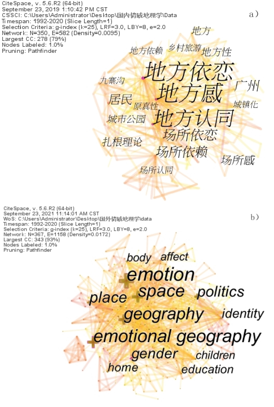
Owing to the long-term acceptability principle of geography, emotion has always been in a relatively marginal position in the study of geography. With the emotional turn of western geography, the research of human-centered "emotional relationship" has gradually attracted great attention from domestic and foreign scholars. To grasp the research ideas, research methods, research hotspots, research progress, and key scientific issues of research in emotional geography of domestic and foreign scholars, this study used the bibliometric method to sort out, summarize, and condense 265 foreign language documents and 248 Chinese documents with the theme of "emotional geography" from 1992 to 2020. The study discussed the quantitative relationship, temporal and spatial distribution rules, distribution characteristics, and characteristics of emotional geographic literature at home and abroad. Gephi software was used to visually present research cases at home and abroad, and Citespace software was used to analyze the co-occurrence knowledge graph of keywords in the literature and to clear the research hotspots of emotional geography at home and abroad. The connotation and significance of the research have been explained, and the research prospects are put forward. The study concluded that the key scientific issues of emotional geography include five aspects: constructing a theoretical model of emotional geography with Chinese characteristics, establishing a sound system of emotional geography research methods, promoting the integration and interdisciplinary research of emotional geography and other disciplines, exploring the operating mechanism and practice path of emotional geography for stabling emotions, peace of mind, and understanding society, and studying the impact mechanism of human emotional needs on the construction of local space. There were many research topics at home and abroad, and foreign research hotspots mainly focused on politics, education, gender and climate, whereas domestic research focused on sense of place, tourism, and residents. After nearly 30 years of research on emotional geography at home and abroad, it can be divided into three stages: initiation, expansion, and volatility growth. Research methods have also gone through three stages: from qualitative descriptive analysis to the combination of qualitative and quantitative, innovative and diversified quantitative methods, and collaborative qualitative research. Academia has reached a consensus on the three-dimensionality of "person, emotion, place (space)," but only a few scholars have defined the concept of emotional geography. Thus far, cognition has not been unified, hindering the research process of emotional geography. Based on the complex patterns of emotional geography, time-complex processes, and time-space complex features, follow-up research is needed to collaboratively couple with multidisciplinary theories and methods to find a scientific, typical, representative, and practical theoretical system. There is also a need for qualitative and quantitative research methods combining with the analysis of cultural self-confidence, rural revitalization, homesickness, and uniquely Chinese characteristics of "emotional relationship" and other social hot topics, to provide valuable and scientifically based references for follow-up emotional geography research, expand scholars' research horizons, promote the theoretical and systematic research of emotional geography with Chinese characteristics, improve the academic influence and discourse power of emotional geography, and serve mankind better.
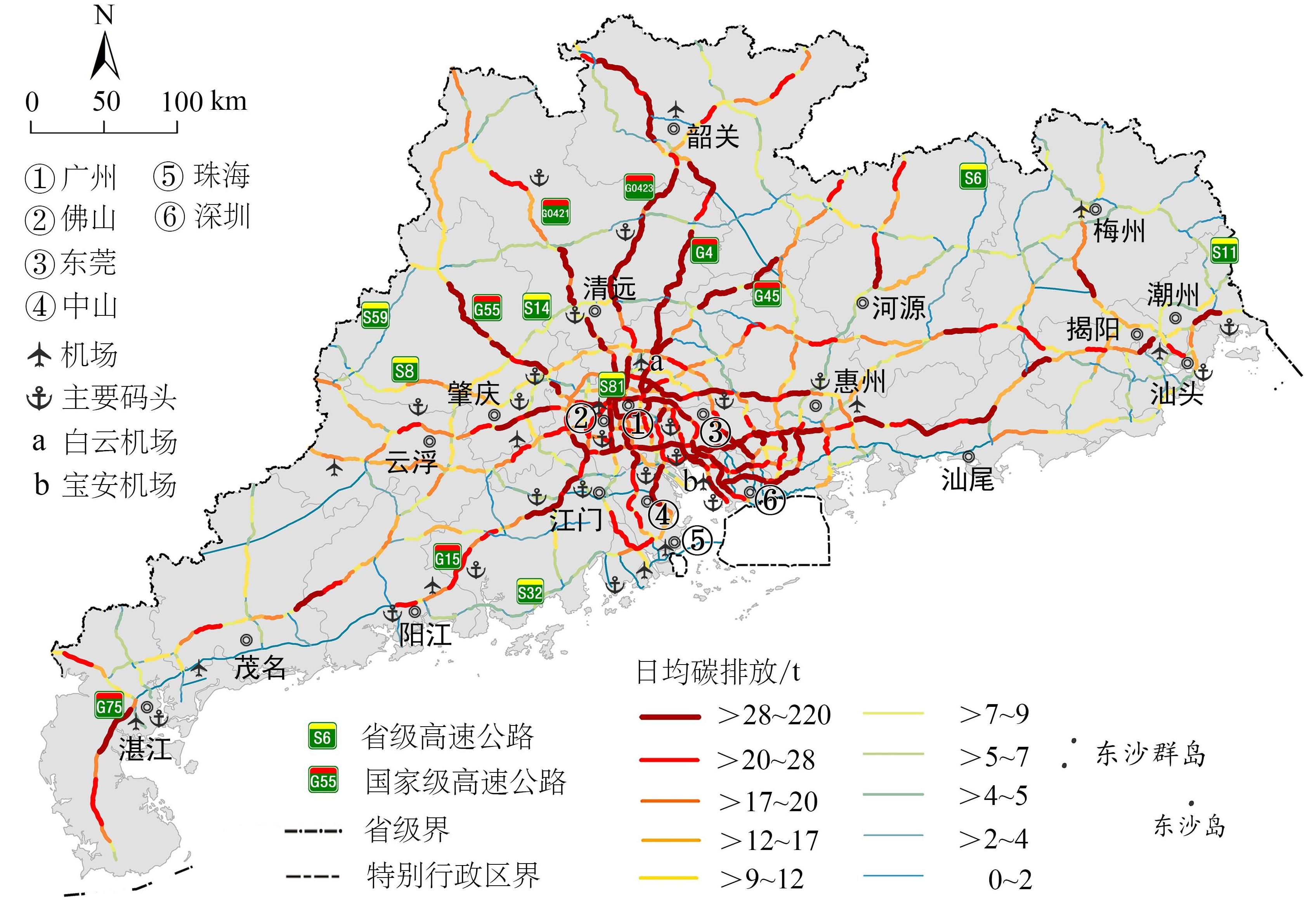
The transportation sector has become one of the largest industrial emissions source of greenhouses gases, such as CO2. What's worse, carbon emissions from this industry has continued to grow in recent years, posing serious challenges to human survival and global environmental security. Among the various transport modes, road transportation yields the highest levels of energy consumption and CO2 emissions. Therefore, scientifically measuring highway carbon emissions and analyzing their spatial differences are of great significance for energy conservation and emission reduction in the transportation sector. Taking Guangdong Province as an example, this study constructs a full-samples and high-precision carbon emissions model, which encompasses Class I~IV passenger cars and Class I~VI freight vehicles based on origin-destination traffic flow data recorded by the highway networking toll system. Finally, the study explores the spatial difference in carbon emissions of highways in Guangdong Province by using geospatial methods. The conclusions are as follows.Firstly, carbon emissions from highways in Guangdong Province mainly came from trucks, which accounted for 57.1% of the total carbon emissions; passenger cars accounted for 42.9%. To be specific, the carbon emissions mainly originated from small and medium-sized vehicles, including Class I passenger vehicles (i.e., cars) and Class I and III freight vehicles. Secondly, the high carbon emissions road sections were spatially auto-correlated, with peak aggregations on national highways, near economically developed and densely populated areas, and adjacent to airports and ports. Road sections with high carbon emissions in Guangdong Province were concentrated along national highways (9,477 t; 61.9%); the carbon emissions of provincial road sections were relatively low (5,834 t; 38.1%). The high-emission sections of passenger vehicles were mainly concentrated in the Pearl River Delta and radially distributed outwards along Guangzhou City. The high-emission sections of freight vehicles were mainly distributed in national highways. The smaller volume of trucks, the more concentrated the spatial distribution of carbon emissions. Furthermore, at the city scale, the cities with higher carbon emissions were mostly concentrated in the Pearl River Delta urban agglomerations, and Guangzhou had a evident primary city effect. The cities with lower carbon emissions were mainly concentrated in coastal areas, such as Zhuhai. At the county scale, the spatial non-equilibrium characteristics of the carbon emissions were significant. The counties with higher carbon emissions were located in the northern part of Guangdong Province and the center and east coast of the Pearl River Delta.Finally, different types of vehicles had differentiated carbon emission characteristics and emission reduction paths. For example, based on the large quantity and significant carbon emissions of Class I passenger vehicles, we must optimize the energy structure to increase the proportion of vehicles using renewable energy sources. Owing to the high unit fuel consumption of Class VI freight vehicles, improving their operation efficiencies is crucial to avoid empty carriages (i.e., no cargo) and we must optimize their driving routes. This research improves the scientificity and spatial analytical accuracy of measuring traffic carbon emissions, thus enriching the sustainable development theory of the transportation, practically promoting the precise emission reduction and green development of the transportation industry, and providing technical and strategic support for attaining dual carbon targets in China.
Excess commuting is an important indicator to understand the spatial organization and commuting efficiency of the urban job-housing space. With the advantages of full sample and high precision, cell phone signaling data help describe the urban job-housing relationship and commuting pattern at the micro scale. The job-housing relationship pattern at the micro scale is conducive to a more accurate assessment of urban excess commuting. Using cell phone signaling data to construct a job-housing Origin And Destination (OD) contact matrix of the Residents' Committee, this study analyzes excess commuting and its micro-structure in Guangzhou. This study finds the excess commuting in Guangzhou to be 76.01%, which is relatively high compared with that of other cities in China as well as cities in the West; this indicates that the overall efficiency in job-housing spatial organization is low. From the perspective of local excess commuter rate, there are obvious characteristics of high excess commuter rate at the edge of the region and in the old city, and the distribution of high excess commuter rate has a certain correlation with the direction of subway rail transit. The construction of rail transit tends to reduce residents' sensitivity to commuting distance, which leads to an increase in excess commuting. Simultaneously, large suburban real estate communities and industrial agglomeration areas have a high excess commuting rate because of the relatively single urban function. Although the function of the city center is relatively diversified, it is easy to form a high excess commuting rate due to the impact of high cost of living. In the suburbs of Guangzhou, areas with specific functions, such as University Towns and urban villages, have a lower excess commuting rate and better organizational efficiency in the job-housing space. Relevant public policies to improve the spatial organizational efficiency of job-housing in big cities require not only focusing on improving the balance of regional job-housing but also placing great emphasis on optimizing the urban functional structure and reducing regional differences in housing costs. Excessive single functional development in the suburbs will affect the job-housing balance in the region. Hence, it is necessary to avoid large-scale "sleeping cities" and industrial new towns. The choice of workplace and residential location is often a rational one made based on cost of living and commuting. Reducing regional differences in cost of living is the most important way to eliminate the regional job-housing imbalance. Strengthening the equalization of public service facilities between central urban areas and suburbs, improving the traffic convenience in suburbs, and reducing regional differences in housing prices are important measures to reduce regional differences in cost of living.
The establishment of nature reserves is an important measure to protect rare wild animals and plants and their habitats. This plays a positive role in alleviating the ill effects of change in land use and protecting ecological diversity. Since the establishment of the first nature reserve in China, there has been notable development in the construction and infrastructure industry. Owing to this development, understanding whether nature reserves can effectively achieve the purpose of protection has gradually become a hot topic. An in-depth understanding of the evolution of land use types in nature reserves and their adjacent areas can evaluate the effectiveness of the construction of nature reserves, provide decision support for land resource planning, and help maintaining the balance of the ecosystem and sustainable development. Understanding the spatio-temporal evolution pattern of land use is important to create and preserve ecological security in protected areas. In this research, we studied the land use dynamics in Guangxi Golden Camellia national nature reserve and its adjacent two-kilometer buffer zone. Land use information was extracted from seven Landsat TM/OLI images from 1986, 1994, 1999, 2004, 2009, 2014, and 2019. The spatio-temporal dynamics of land use over the past 35 years were studied using decision tree analysis and a transition matrix. The results showed that the land use in the reserve is mainly dominated by forestland, and the adjacent areas of the reserve is mainly dominated by forestland and arable land. Although the proportion of construction land is small, it has increased annually over the past 35 years. It was observed from the studies that the dynamic degree of construction land was always relatively high in the non-core region of the reserve and the adjacent areas, whereas the dynamic degrees of other land types fluctuated more gently, and the integrated land use dynamic degree of the adjacent areas was less. The core area changed more drastically, the change in the trend of the comprehensive land use dynamic degree in the adjacent areas and the non-core area was similar. After the establishment of the reserve, human disturbance was reduced in this region, and the land-use pattern became more stable. Furthermore, the conversion of land use types in the adjacent areas was frequent, of which the transfer and exchange between cultivated land and forest land was the most drastic, the conversion of land use in the non-core region was less. This shows that the establishment and management of the reserve effectively protects the local ecological environment. Additionally, the studies showed that the migration of the land use center of gravity had a certain direction. The center of gravity of all land use types in the non-core area of the reserve generally migrated to the northeast, and the center of gravity of construction land and cultivated land in the adjacent area of the reserve generally migrated to the west, indicating that the expansion of the original construction land had a strong influence on land use dynamics. The management of the reserve has achieved relatively remarkable effects and the ecological environment inside the reserve has been improved, but the slow increase of land for internal construction and resources exploitation still have a negative impact on the habitat quality of the reserve. This study provides data to support the dynamic monitoring of land use and further improvement of protection and restoration measures in subtropical natural reserves.
In the era of life aesthetics, tourism and life are intertwined, and tourists' needs and behaviors are changing from a hasty landscape gaze to diversified lifestyles. Lifestyle is an overall preference that shapes the individual's life patterns and behavior habits. Tourism activities are characterized by a strong emotional consumption. The Structural Equation Modeling (SEM) is used for empirical analysis. Based on the appraisal theories of emotion, the study discusses the influence mechanism of lifestyle on tourist travel photo sharing behavior in the Xi'an Tang Paradise through emotional intermediary variables. The results show the following. First, lifestyle has no significant positive impact on tourists' travel photo sharing behavior. It can be the product of objective environmental conditions or the choice of individual subjective consciousness. However, there are contradictions and differences between subjective and objective influencing factors. Moreover, tourists' capital-owned attribute and their own dispositional tendency are not always consistent. Lifestyle has an important indirect impact on tourists' travel photo sharing behavior under the mediating effect of the sense of travel ritual and self-identity. Second, lifestyle has a significant positive impact on tourists' sense of tourism ritual, authenticity perception, and self-identity. This conclusion confirms that tourism activities are essentially an emotion-led process, which is convenient for understanding the emotional consumption characteristics of tourism activities in the context of consumption upgrading. Third, the sense of travel ritual and self-identity have a significant positive impact on tourists' travel photo sharing behavior, and play a mediating role between their lifestyle and travel photo sharing behavior. This study verifies the conclusion that ritual sense, as a positive emotion, can prompt people to share positive experiences, and provides a strong argument for tourists' ritual sense that affecting tourists' sharing behavior from a micro perspective. Furthermore, this study also echoes the scholars' arguments that lifestyle is a way of self-expression and declaration, and confirms the conclusion that self-identity can promote tourists' photo sharing behavior. Fourth, authenticity perception has no significant positive effect on tourists' travel photo sharing behavior, and does not play a mediating role between their lifestyle and travel photo sharing behavior. There are three reasons for this. First, the commercialization trend of the tourism resources of Tang Paradise is gradually serious, and the authenticity of the object on which the cultural landscape depends is gradually weakening. Second, the application of modern technology and excessive "stageization" make the rituals and activities of the Tang Paradise deviate from the cultural authenticity, weakening tourists' perception of authenticity. Finally, there are few immersive interactive experience projects in the Tang Paradise, which are difficult to trigger tourists to achieve the psychological state of the "real self." The study clarifies the mediating role of three emotional variables, namely: sense of tourism ritual, perception of authenticity, and sense of self-identity in the relationship between life style and tourists' travel photo sharing behavior. This enriches the research connotation of lifestyle in theory, infiltrates the study of lifestyle from a consumer sociology into the field of tourist behavior, and simultaneously expands the research on the antecedent variables of travel photo sharing behavior. Additionally, under the background of the strong intervention of information technology, the tourists' own characteristics, emotional psychology, and social sharing are studied in the same model, expanding the research content of positive psychology and communication, and rationally considers the influence of positive psychology on social media communication. Finally, in practice, it has certain enlightening significance for enriching tourists' experience, optimizing emotional marketing, and promoting the transformation and upgrade of tourism service quality in the Tang Paradise.
Place is an aggregate of meanings based on the emotional connection between people and a physical locality, fraught with social and cultural significances. It provides a spatial anchor for memory construction, value perception, and emotional experience for individuals and groups. Among the variegated factors that contribute to the construction of place, collective memory assumes a prominent role. On the one hand, local material conditions and landscapes provide clues and references to the past, essential for the construction of collective memory. Conversely, collective memory is embedded in the ongoing negotiation and production of locality and spaces, which contributes to specific ways of narrating a fluid and dynamic place identity. Taking Xinzhuang Village in Binchuan County, Yunnan Province as a case study, this article analyzes the process of place reconstruction based on local collective memory in the context of red tourism development, focusing on its specific spatial manifestations of memory and analyzing how collective memory participates in the production of local cultural identities. The fieldwork results show that different local actors in the village participate in the remaking of collective memory differently and with different priorities. The reconstruction of collective memory is accompanied by the continuous negotiation of identity, social relations, and communal organization. Collective memories give rise to shared patterns of everyday life and symbolization: reconciling the relationships between different groups. Specific attributes of place provide the basic building blocks of collective memory, which in turn reshapes material spaces and local cultural performances. Place identity, and vice versa, continuously strengthen collective memory in the construction of a red tourism destination. Collective memories facilitate the creation of a renewed local context. In this context, collective memories are performed and regenerated in embodied practices such as rituals and tourism behaviors, which constantly inject new cultural connotations into place reconstruction. At the same time, collective memory continuously guides spatial practices and the production of social and material spaces. This paper concludes that place elements not only trigger the recall, storage, and recreation of memory in the context of red tourism but also express the local characteristics, cultures, and identities reconstructed by collective memory. In this process, the landscape construction of Xinzhuang village endows collective memory with stability and persistence, and we argue that place concretizes and contextualizes collective memories. Thus, the interaction between memory and place both enhances the place identity and memory, especially for those who inhabit the place. The cultural landscapes, and local discourses constructed by collective memory have become the most significant local attributes in the process of expressing placeness. In response to the view that the place is understood as continuous change and dynamic construction, this paper understands collective memories as fluid, dynamic and socially negotiated, and clarifies the dialectical, mutually constitutive relationships between place and memory. It addresses the relative dearth of research on the construction and reconstruction of collective memory from the perspective of place and place identity.
The stable hydrogen and oxygen isotopic composition of precipitation or water vapor not only shows the response to climate change on different time scales, but also has a strong relationship with typhoon extreme weather events. Typhoons usually bring destructive disasters, such as extreme rainstorms, strong winds, and storm surges, which have a significant social and economic impact worldwide. Therefore, the evolution of the typhoon weather process and the source of water vapor are worthy of attention. The stable isotope composition of water vapor can reflect more detailed weather process information than the stable isotope of precipitation, but available research on the stable isotope of water vapor in the atmosphere during a typhoon event is far less extensive and in-depth than that of precipitation. Based on the real-time high-frequency monitoring of water vapor stable isotopes of Nanjing before and after the impact of typhoon Soudelor (1513) combined with reanalysis data, the HYSPLIT model focused on analyzing the relationship between water vapor δ18O and weather processes and the water vapor indicated by excessive deuterium in the water vapor source. The results showed that the water vapor δ18O remained primarily constant and then decreased, while the excess deuterium of water vapor showed a completely opposite trend to that of water vapor δ18O. According to the change characteristics of water vapor δ18O, it is divided into three stages: In the first stage, the high δ18O level reflected the stable atmospheric conditions in Nanjing, and the low excess deuterium indicated that Nanjing was mainly influenced by marine water vapor. The low excess deuterium indicated that the water vapor source is consistent with the simulated water vapor source. In the second stage, the typhoon circulation and its residual pressure and the interaction of the cold air from the north to the south caused heavy precipitation in Nanjing. The combined effect of water vapor condensation and rainfall evaporation led to the continuous depletion of water vapor δ18O, and the high water vapor excess deuterium indicated that the Nanjing area was mainly affected by the ocean and the influence of local mixed water vapor. The high excess deuterium indicated that the water vapor source was consistent with the model. In the third stage, the mesoscale downdraft may have led to the extremely negative δ18O and high water vapor excess deuterium in the study area, which is not consistent with the water vapor source simulated by the model, indicating that the water vapor excess deuterium was not only affected by the horizontal water vapor transport source, but also by the downdraft. The analysis of time series data of water vapor stable isotopes revealed the relationship between local and microphysical processes and the evolution of water vapor stable isotope composition. A full understanding of the stable isotopic composition of modern water vapor under typhoon extreme events can assist with the understanding and interpretation of isotopic data in geological archives.
As an important weather system, domestic and international scholars have studied the front for a long time. The Dian-Qian quasi-stationary front is also called the Yun-Gui quasi-stationary front, and many scholars call it the Southwest quasi-stationary front. It refers to the phenomenon that in East Asia, cold air outbreaks that spread southward cannot cross the plateau because they are obstructed by the topography of the plateau. The frontal system is formed when the cold air and the warm, wet air from the southwest of the Bay of Bengal meet. Every year, weak quasi-stationary fronts frequently affect Guizhou Province in late autumn and early winter. The appearance of such a stationary front is less obvious than that of winter, and is generally difficult to predict or forecast. However, when it appears, it is not only difficult to grasp the weather phenomenon, but also to forecast the temperature due to its influence. Moreover, the relative error of some observation sites can even reach 10.0℃ or higher. It has greatly affected forecasting services, production, and people's activities. Therefore, this study used the ECMWF fine-grid 2 m temperature forecast and ground comprehensive observation data from November to December 2010 to 2021, and the daily maximum and minimum temperature forecasts within 72 hours from 84 national observation stations in Guizhou were examined and evaluated. The results showed that the prediction accuracy was significantly reduced, whereas the mean root square error was significantly increased during the quasi-stationary front activity relative to the mean state. Furthermore, the forecast accuracy was less than 20% in 2014, nearly erasing the forecasting ability. Therefore, 19 cases of stationary front weakening and moving northward in 2014 were synthesized and their circulation characteristics were compared with the mean state. The results were as follows: at 200 hPa, compared with the mean state, the inlet of the jet stream moved eastward during the activity of the quasi-stationary front, the northern and southern boundary became narrower, and the average intensity of the jet stream center decreased from 65.0 m/s to 60.0 m/s; at 500 hPa, the characteristic of trough and ridge in the middle and high latitudes became less obvious, the cold air force weakened, and the latitude direction of circulation increased. In terms of factor characteristics, the temperature in the middle and lower layers showed a significant warming state relative to the average state, the inversion state of 700-850 hPa weakened or even dissipated, and the lower southerly wind strengthened and the vorticity increased. In conclusion, through the abnormal analysis of the circulation situation and the element field, when the Dian-Qian quasi-stationary front weakened and moved northward, the intensity and location characteristics of the circulation and the element field changed relative to the average state. Therefore, in our forecast, we can assess whether the Dian-Qian quasi-stationary front weakens the northward movement based on various characteristics of intensity and position. It can provide insights into the forecast and service work of temperature, as well as weather phenomena and other factors in our daily lives.
Groundwater flow in tidal wetlands is an important part of coastal estuarine hydrological cycle. The results of previous studies were based on the condition that the aquifer was homogeneous. Moreover, the understanding of groundwater circulation in tidal wetlands under heterogeneous aquifer medium is still insufficient. To explore the characteristics of groundwater flow in tidal wetlands under heterogeneous conditions and reveal the groundwater circulation process of wetlands, this study used a typical estuarine tidal wetland in Nansha District of Guangzhou as the research object. After analyzing the characteristics of the heterogeneous aquifer medium in the wetland, the groundwater flow characteristics under the heterogeneous aquifer were investigated using the radioactive radon isotope tracer technique. The results showed that the dry bulk density, porosity, radon release, and radon equilibrium capacity of the studied medium exhibited spatial heterogeneity. The dry bulk density of the medium varied from 0.39 to 1.44 g/cm3 and increased gradually from land to river and shallow to deep. The overall porosity of the medium varied from 0.42 to 0.78 without evident regularity. The main factor affecting the spatial distribution characteristics of the equilibrium capacity of the medium radon was its release. The former varied from 2,210.15 to 7,700.33 Bq/m3 and had a good positive correlation with the latter (R2=0.69). Under the condition of heterogeneous aquifer, the analysis of the total head of groundwater in the tidal wetland during ebb tide showed that the groundwater flowed from shallow to deep and land to river in the aquifer far from the tidal river. However, in the wetland aquifer close to the tidal river, the state of the groundwater flow changed and showed a trend from deep to shallow. According to the spatial distribution characteristics of radon specific activity, groundwater flow in tidal wetlands was divided into fast-flowing and retention zones. The radon-specific activity of the groundwater in the fast-flowing area was relatively low, with an average of 1,522.39 Bq/m3 during the observation period. The groundwater showed an approximately U-shaped flow mode from land to river. The radon specific activity of groundwater in the retention area increased substantially, with an average of 3,858.40 Bq/m3 during the observation period. In addition, the state of the groundwater flow in the retention area was affected by the difference in the tidal height. The larger the difference between the tidal heights, the greater the driving force of the tide on wetland groundwater; the seepage of groundwater in the retention area was relatively easy, and vice versa. Based on the actual heterogeneity of the aquifer, this study measured and analyzed the characteristics of groundwater flow in tidal wetlands, which is an important step relative to previous research on homogeneous conditions. It is of great importance to ascertain the groundwater flow in tidal wetlands under actual conditions. In the future, we can further clarify the influence mechanism of the heterogeneity of different media on the characteristics of groundwater flow in tidal wetlands, quantify the groundwater circulation process, and provide constructive suggestions for production activities and sustainable development.