The Wuyi Mountains preserve the most complete central subtropical forest ecosystem in the subtropical zone, where the vegetation and soil have a distinct vertical distribution with elevation. To investigate the relationships between surface pollen assemblages and vegetation in this area, 76 samples of modern surface pollen with minimal human interference were collected from various elevations in the Wuyi Mountains. Based on the results of cluster analysis and redundancy analysis (RDA), this study indicates the connections between the distribution of pollen taxa at different elevations and under different climatic factors. The primary findings are outlined as follows: 1) Pinus, Castanopsis/Lithocarpus, Cyclobalanopsi, Quercus (evergreen), Taxodiaceae, Schima, Rutaceae, Ilex, Rosaceae, Poaceae, and Artemisia were the dominant pollen taxa, generally corresponding to the modern subtropical broadleaved evergreen forest. The pollen assemblages showed clear changes with variation in altitude; the relationships between pollen taxa and elevation were divided into three patterns: The low altitude areas (0-450 m) had a high percentage of Castanopsis/Lithocarpus, Quercus (evergreen), Theaceae, Schima, Ilex, Poaceae, and Dicranopranis. In the middle elevation area (450-1,850 m), Castanopsis/Lithocarpus, Pinus, Taxodiaceae, Tsuga, and Quercus (evergreen) were common. The higher altitude area, at approximately 1,850-2,200 m, was characterized by the dominance of Pinus, Poaceae, and Dicranopteris. 2) The results of RDA and cluster analysis divided surface pollen samples into different communities. RDA results also showed that the mean annual temperature, mean annual relative humidity, mean annual precipitation, mean precipitation of the coldest season, and mean precipitation of the warmest season were the main climatic factors that controlled the distribution of modern pollen. 3) The results of the representative analysis of pollen showed that Castanopsis/Lithocarpus, Pinus, Quercus (evergreen), and Artemisia were over-represented, and the genera Tsuga and Poaceae were represented less; 4) lower elevations had a significant presence of Poaceae, Artemisia, and Pinus. The pollen content of Quercus (evergreen) was low and the pollen type was relatively simple; it was related to the development of artificial pinewood in the foothills and the high spore content in the secondary forest, which indicated heavy human activity in the low altitude area. Therefore, these results revealed that the surface pollen assemblage varied significantly through the vertical vegetation zones in Wuyi Mountains of south subtropical China. The characteristics of surface pollen distribution were mainly affected by vegetation composition, habitat, and human activities, which is a crucial reference for reconstructing the paleovegetation and paleoenvironment in this region and similar areas.

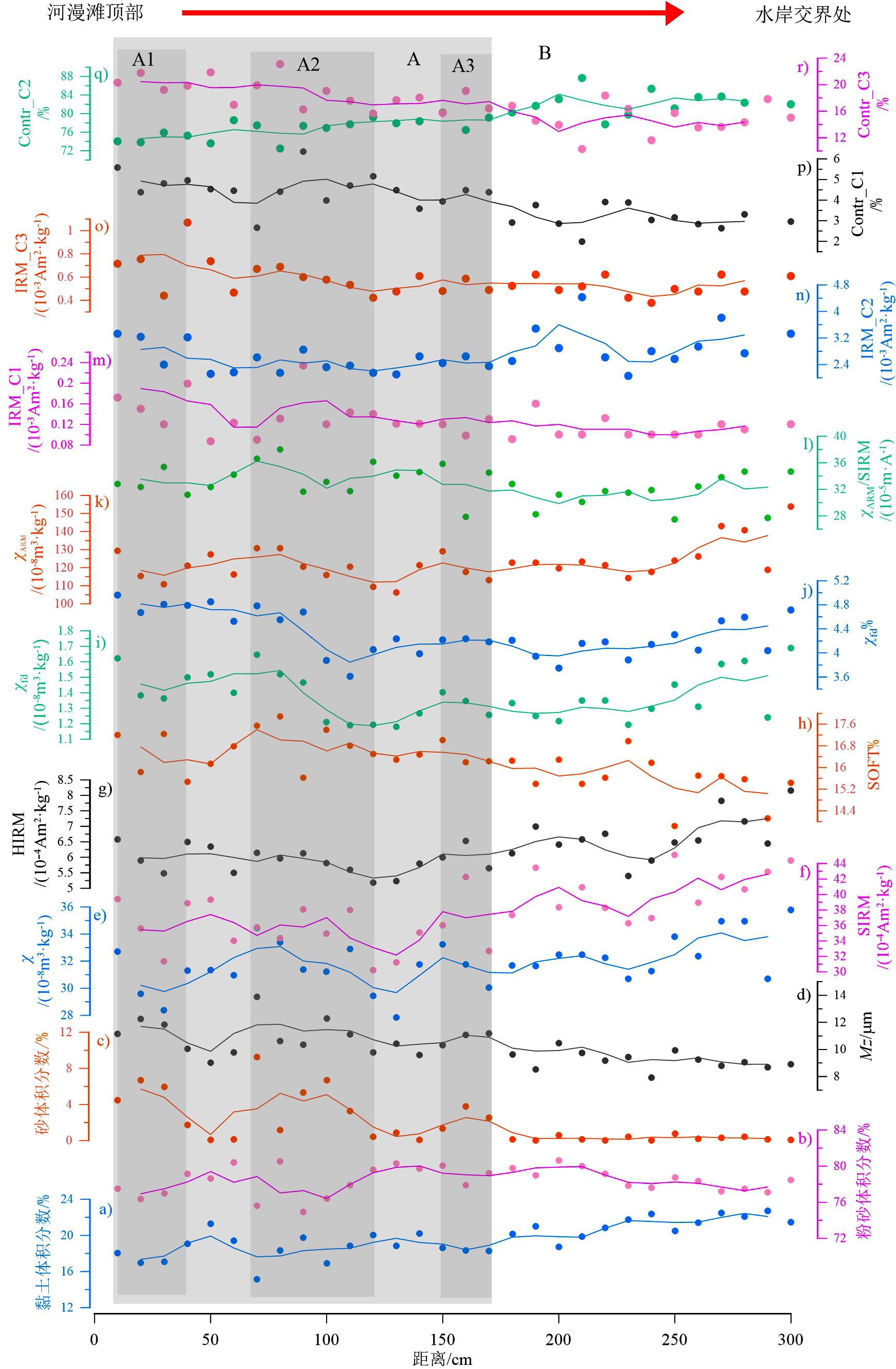
With the intensification of global climate change, floods caused by typhoons and heavy rainfall occur frequently. It is important to effectively identify flood events within sedimentary records to study the flood frequency patterns. Currently, grain size analysis is the commonly applied method for flood event identification. The hydrodynamic conditions and sediment sources identified from the grain size parameters are used to distinguish flood events. However, identification results from a single index can easily lead to inaccuracies due to complex river sedimentation processes. Therefore, it is necessary to select the most suitable proxy and, in combination with the implications of different types of indicators, identify flood events in study areas. In addition to grain size analysis, the technology of environmental magnetism has been widely applied in the sedimentology research of flood sediments owing to its advantages of sensitivity, rapidity, economy, and non-destructiveness. In this study, a longitudinal floodplain sediment profile collected from a small watershed in northern Guangdong was selected as the research object. Both grain size and magnetic characteristics of the entire profile were determined in detail. Based on the flood event records identified by sediment grain size characteristics, an in-depth analysis of the magnetic characteristic differences between the flood sedimentary layers and normal sedimentary layers, was performed. We aimed to establish a set of suitable magnetic parameters for identifying flood events in this region. Consequently, a new approach can be used to identify paleofloods within sedimentary records. The results indicate the following. 1) The sediment particle size composition is primarily composed of silt, which accounts for more than 70% of the total. Moreover, the sediment particle size tended to become finer from the flood sedimentary layer to the normal sedimentary layer. Three sublayers characterized by relatively high peak values of sand content and mean grain diameter were identified as flood event sediments within the flood sedimentary layer. 2) The composition and sources of magnetic minerals within the sediments from different sediment layers are similar. The predominant magnetite and some hematite within the sediments are from the natural weathering of parent materials within the watershed. Exogenous input from the tailings pond of the Dabaoshan mine is another source of magnetic particles. 3) As deposition is dominated by suspended sedimentation in the study area, sediment sorting is sufficient under the influence of a continuous long-term high-water level. As a result, the magnetic particles within the flood sedimentary layer are relatively fine. With the enhancement of hydrodynamic conditions, the grain size of the magnetic particles and the concentration of fine-grained magnetite and hematite became coarser and increased in the three identified flood event sublayers within the flood sedimentary layer (from the middle to the top of the sedimentary profile). Therefore, a combination of environmental magnetic parameters and magnetic mineral composition analysis can be used for the accurate identification of flood events recorded by sediments. In the study area, the magnetic characteristics of the relatively high contributions of fine-grained magnetite and hematite and the relatively low contribution of coarser magnetite to saturation isothermal remanent magnetization can be regarded as proxies for identifying flood events and strong hydrodynamic conditions.
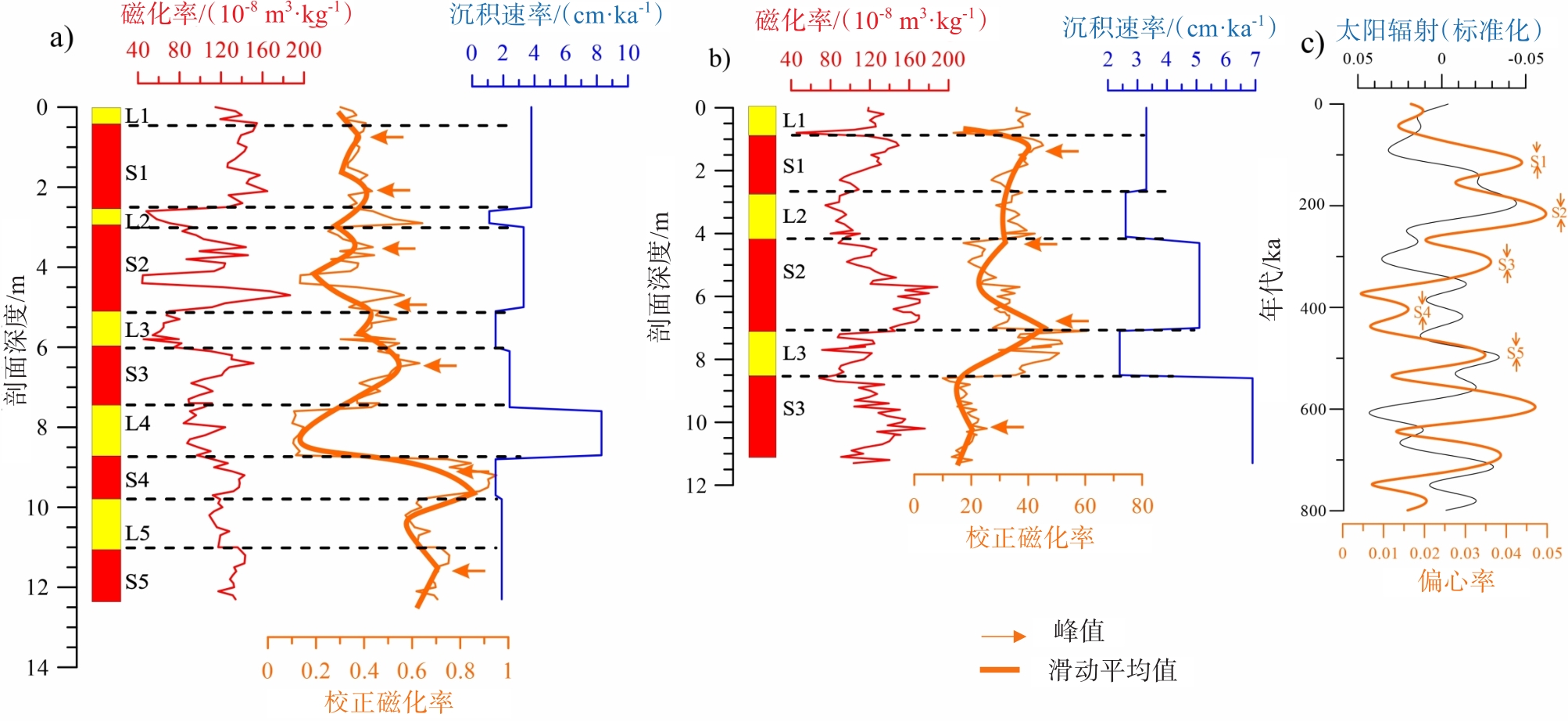
Quaternary Xiashu loess deposits are widely distributed in the middle and lower reaches of the Yangtze River. The Xiashu loess deposits provide an important archive for studying the area's paleoclimate. We analyzed the magnetic susceptibility of 239 bulk samples from two newly excavated Xiashu loess profiles: the Puwulu and Pancheng. Based on a comparison with previously studied profiles in this region, our new record shows a good correlation in the stratigraphy, with three well-developed paleosols (layers S1, S2, and S3) as the marked layers. This correlation was observed in the Taishanxincun, Laohushan, and Dagang profiles. Despite the good spatial correlation in stratigraphy, the well-developed paleosol layers were thicker than the underlying loess layers. The average sediment accumulation rates in the paleosol layers (6.2 cm/ka, n=19) were higher than those in the loess layers (5.1 cm/ka, n=17). This stratigraphic feature of the Xiashu loess deposits differs from that of the Chinese loess plateau in North China. Combined with previous studies on the origin of the Xiashu loess deposits, the new records suggest a proximal origin; however, the dominant contribution of sediment materials from the floodplains at the foot of Laoshan Mountain. Increased material flux through the primary stream runoff on the floodplain resulted in higher sediment accumulation rates in the paleosols. Based on sedimentary model analysis, the paleosol and loess layers in the Xiashu deposits are continuous sedimentary records on glacial-interglacial scales. After adjusting for fluctuating sediment deposition rates, the revised magnetic susceptibility displayed a clear cyclic variation pattern, which was interpreted as the intensity of pedogenesis. Power spectral analysis suggests that the cyclic pattern of variations shows a strong frequency in the 100 kyr band for both the Pancheng and Puwulu profiles. This may explain the paleoclimatic dynamics of the paleosols that formed. The most developed paleosol layers (S1, S2, S3, S4, and S5) correlated well with the orbital parameter eccentricity with clear 100-kyr ice cycles. Ice age terminations suggest sea-level changes and a far-reaching influence on precipitation in the middle and lower reaches of the Yangtze River. These observations indicate the relationship between the glacial cycle and soil development is closer than previously believed. The coincidence with eccentricity may largely support the idea that changes in global ice volume have promoted the formation of strongly developed paleosols along the incised valleys of the Yangtze River.
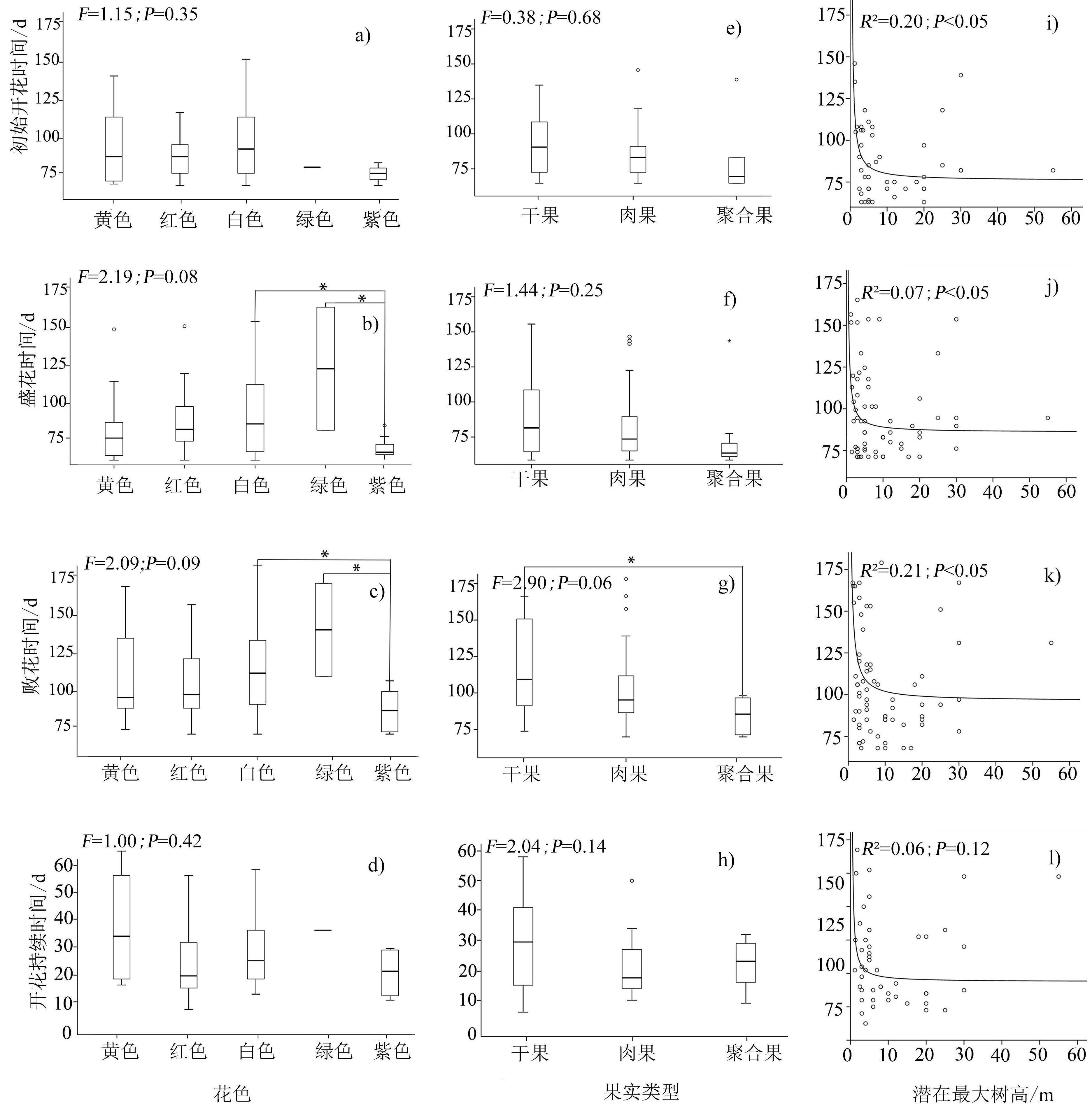
Flowering phenology is closely related to plant reproduction, and its response to climate change is obvious; therefore, revealing its influencing factors and interspecific changes has become an important issue in global change ecology and physical geography. Previous studies have reported that interspecific changes in flowering phenology are affected by climatic factors (such as temperature and precipitation) and related to plant functional traits. However, the magnitude of the correlation between functional traits and flowering phenology varies greatly among different regions and climatic zones, and the relationship between them remains unclear. In this study, to explore whether functional traits affect interspecific changes in the flowering phenology of subtropical evergreen broadleaf species, 67 woody species in the Ningbo Botanical Garden were chosen as the study objects. Four types of flowering phenological characteristics (initial flowering time, full bloom time, falling flower time, and duration of the flowering period) were observed. General statistical analyses (i.e., maximum, minimum, mean, coefficient of variation, and frequency) were used to test the distribution patterns of flowering phenology. Four statistical methods (independent samples t-test, one-way analysis of variance, linear fitting, and generalized linear mixed effect regression models) were used to analyze the differences in flowering phenology between different types (tree vs. shrubs, different types of flower color, and fruit type) and the contributions of different functional traits (i.e., potential maximum tree height, life form, flower color, and fruit type) to the changes in flowering phenology. The results showed that: (1) the initial flowering time, full bloom time, falling flower time, and duration of the flowering period of 67 woody plants were March 28 ± 21.64 d, March 30 ± 27.02 d, April 15 ± 30.78 d, and 23.82 ± 13.31 d, respectively. (2) The initial flowering time and full bloom time of trees were significantly earlier than those of shrubs (P < 0.05); however, no significant difference was observed between them in the falling flower time or duration of the flowering period (P > 0.05). The standard deviation of the flowering phenology of trees was lower than that of shrubs, indicating that the flowering phenology of trees was more stable than that of shrubs. (3) The results of generalized linear mixed-effect regression models showed that the effects of the four functional traits on flowering phenology differed. More specifically, flower color significantly affected falling-flower time (P < 0.01). The falling flower time of colored flowers was earlier than that of white flowers. Life form and potential maximum tree height significantly affected the duration of the flowering period (P < 0.01). Plants with higher potential maximum heights have longer flowering periods. In conclusion, our study indicates that the flowering phenology of 67 woody species in the Ningbo Botanical Garden is affected by functional traits. However, the magnitude of the influence is related to the type of functional trait. Flower color and potential maximum tree height contributed more to interspecific changes in flowering phenology than other functional traits. Our results help us understand the variation in flowering phenology among woody species in subtropical regions and provide a new perspective for the theoretical exploration of phenology.
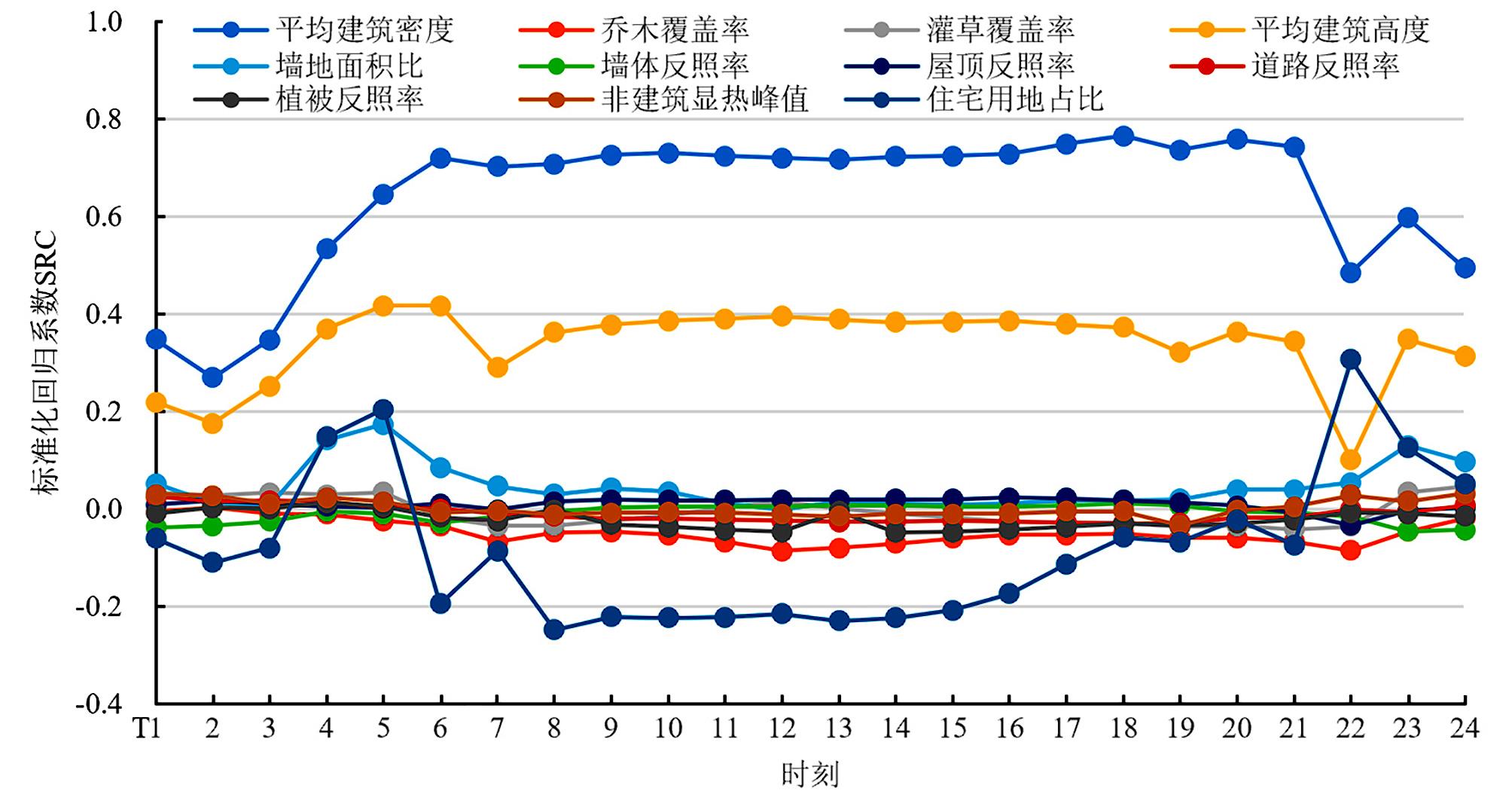
The urban thermal environment problem, represented by the urban heat island effect, has recently attracted increasing attention. However, planning practitioners lack a method to fine-tune the control and management of urban thermal environments. An accurate, rapid, and quantitative urban heat island intensity (UHII) assessment tool is required that is fully integrated into the early planning process. Commonly used remote sensing and computational fluid dynamics methods have temporal and spatial limitations in the rapid and accurate quantitative evaluation and optimization of the urban thermal environment at the early stages of planning. In contrast, simplified numerical simulation methods are better choices considering computational cost and efficiency. In this study, the association between planning control elements and the urban thermal environment was determined, and the spatiotemporal differentiation characteristics of the UHII in the central area of Guangzhou were quantitatively analyzed based on the Local Climate Zone (LCZ) classification system. UHIIs are distinct from LCZs, and the open LCZ types (LCZ 4, LCZ 5, LCZ 8) have a lower average daily UHII of 0.41 °C than the compact LCZ types (LCZ 1, LCZ2, LCZ 3). The UHIIs were affected at different levels by adjusting the urban morphological parameters. The applicability of the simplified numerical simulation method Urban Weather Generator (UWG) was validated by comparing it with the measured data in the central area of Guangzhou. The results showed that the accuracy of the method was good (R2= 0.956, RMSE = 1.10 ℃, MBE = -0.28 ℃), the calculation speed was fast, the daily cycle variation of air temperature in the study area was roughly reflected, and the UWG model was suitable for fine-grained prediction with UHII. Eleven parameters related to the planning control elements were selected for global sensitivity analysis, and the average building density and average building height related to environmental capacity and building construction were observed to be the dominant factors of UHII. Building function and occupancy were secondary factors, whereas urban design guiding elements had less influence on UHII. Hence, combining the LCZ and UWG models not only simplifies the workflow of urban practitioners while analyzing and optimizing the urban thermal environment but also broadens the potential for analyzing the thermal environment in the early planning stage. In evaluating the planning design and implementation of operations and management, the pioneering role of planning control elements in regulating the urban heat environment must be fully considered. With proper planning of land use, environmental capacity, building construction, and guiding urban design, the UHII can effectively mitigate and optimize the urban thermal environment.
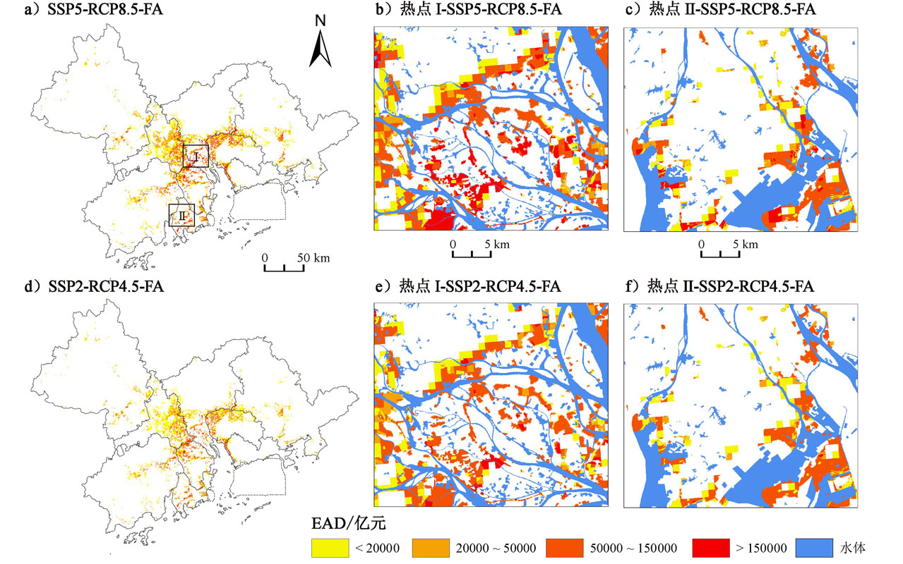
Combined with flood risk avoidance-oriented urban expansion strategies, future urban expansion spatial patterns were simulated under Shared Socioeconomic Pathways (SSPs) and Representative Concentration Pathways (RCPs) scenarios. This study compared urban expansion and expected annual damage to evaluate the flood mitigation effects of different strategies. The results show many newly expanded urban lands in the Pearl River Delta are located in floodplains, and the expected annual damage caused by floods is enormous. The most serious economic losses caused by floods were concentrated in southern Guangzhou, eastern Foshan, northern Zhongshan, and northwestern Dongguan. Under the SSP5-RCP8.5-natural expansion scenario, the newly expanded urban lands in floodplains of the Pearl River Delta in 2080 will be 1,633 square kilometers (equivalent to the built-up areas of Guangzhou, Foshan, and Zhongshan combined in 2021), accounting for 31.5% of the total newly expanded urban lands; the expected annual damage will be 2,341.3 billion yuan. If humans manage to reduce emissions in the SSP2-RCP4.5-natural expansion scenario, newly expanded urban lands located in floodplains can decrease to 1,059 square kilometers (-35.1%), accounting for 29.8 % of the total newly expanded urban lands, and the expected annual damage can be reduced to 1,416.5 billion yuan (-39.5%). If flood risk avoidance strategies are included in the urban expansion to optimize and control the spatial pattern of urban expansion, the direction of future urban expansion can change and steer away from areas with high flood risk and toward areas with low or no flood risk. Under the SSP5-RCP8.5-flood risk avoidance scenario, newly expanded urban lands located in floodplains can decrease to 1,358 square kilometers (-16.8%), accounting for 26.2 % of the total newly expanded urban lands, and the expected annual damage can be reduced to 2,001.0 billion yuan (-14.5%). According to the assessment results, emission reduction, and flood risk avoidance strategies can effectively reduce future flood risks. This study improves our understanding of flood risks under different future scenarios, provides a practical reference for developing flood mitigation and urban planning policies in the Pearl River Delta, and motivates decision-makers to formulate corresponding strategies early and e?ectively to mitigate future flood risks.
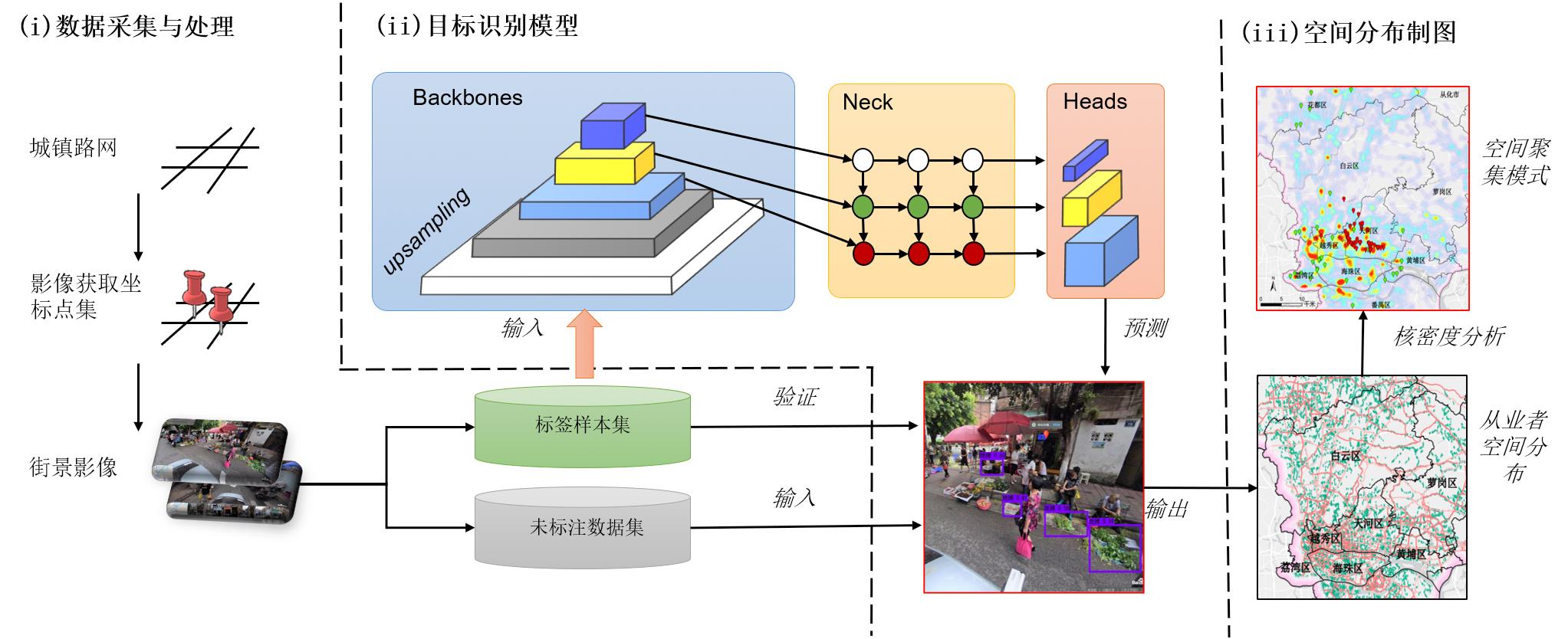
Street vendors are an indispensable part of the urban social ecosystem, but due to a lack of comprehensive understanding, many cities have adopted simple eviction policies, resulting in the gradual marginalization and stigmatization of the street economy. The efficient governance of street vendors requires the comprehensive investigation of their business scale and spatial distribution information. However, traditional methods have limitations in terms of automatically surveying large-scale street vendor information, particularly spatial distribution. This paper proposes a method for the automatic investigation spatial distribution of street vendors based on street-view images and a deep-learning object recognition model. Street-view images were collected at fixed intervals according to the urban road network, and 1,957 images containing one or more vendors were selected through human-machine interaction to establish street vendor label data. To achieve high recognition model accuracy, the category labels were subdivided into four categories: ground stalls, table stalls, tricycle stalls, and small truck stalls, based on the goods carriers used by street vendors. A deep neural-network-based image object detection model based on YOLO v4 was constructed to identify street vendors in the street-view image library, with an average F1 value of 0.77 and an mAP of 0.67. The accuracy of the model was satisfactory for investigating the number and location of street vendors covering the main roads in the city and then applying a kernel density distribution model to evaluate the spatial distribution pattern of street vendors. Using street vendors in Guangzhou as a case study, the proposed automatic investigation model identified 26,119 street vendors from 3,339,062 street-view images. The results showed that the street vendors were distributed in a multicenter aggregation pattern in the central urban area, mainly concentrated in areas with high pedestrian traffic, such as subway stations and urban villages; their numbers increased as road grades decreases. Street vendors were mainly distributed in areas with medium rents. The proposed method is helpful for performing the efficient, low-cost, and city-scale mapping of street vendors; the results obtained provide suggestions for formulating and implementing spatial governance policies for the informal economy and further provide suggestions for improving and implementing spatial governance policies for open and diverse urban street-view images. The results can be used as a reference for the location preference analysis of practitioners, the exploration of NIMBY syndrome, and the determination of the formalization zone. Although street-view images have an insufficient spatiotemporal coverage, using them to perform street vendor investigations is a low-cost and efficient method compared with the use of traditional investigation methods and data sources. In addition, the method proposed in this article can be coupled with multitask deep learning algorithms to investigate additional dimensions of street vendor information, such as the sex, age, and type of business of street vendors. Relevant research needs to be conducted in the future.
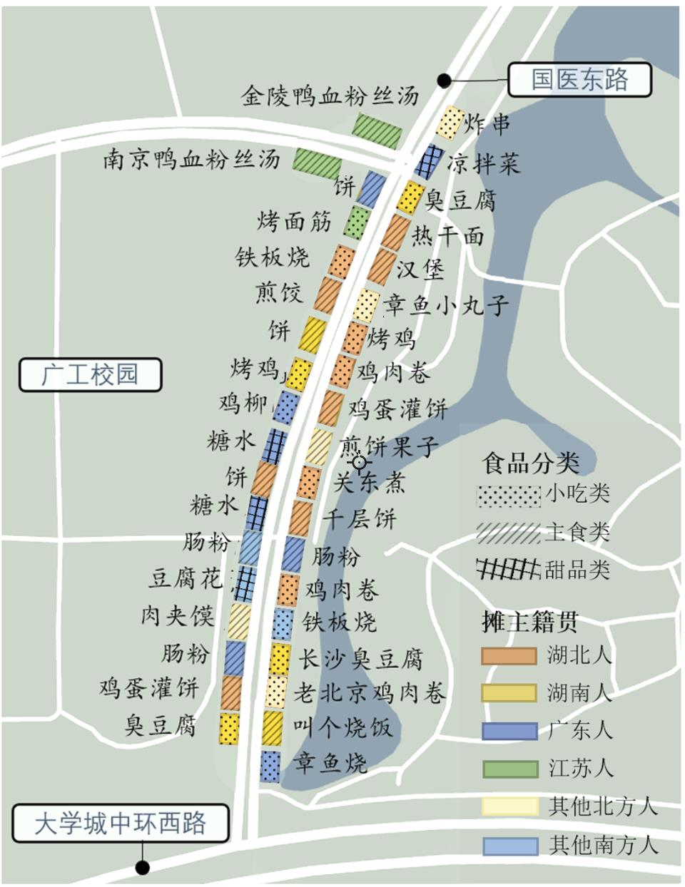
Informal sectors and the production of space are two popular topics in academic research in the 21st century. However, the production and reshaping of space due to the everyday life force of street vendors have been neglected in previous studies, as have relevant studies on university boundaries. Street vendor spaces around colleges have several characteristics that make them an ideal place for space research. A provider of midnight snack services enriches students' lives in college and creates a special atmosphere to promote relationships among students. Nanting Avenue and Guoyi East Road, known as the fifth canteen at the Guangdong University of Technology in the Guangzhou Higher Education Mega Center, were used as case studies. Qualitative research methods, such as semi-structured interviews, participatory observation, and literature analysis, were used to determine the space formation process at three levels: power, physical, and social. By reenacting slices of street vendors' everyday lives, this study analyzed the features, processes, and mechanisms of street vendors' anti-discipline and the social forces of relevant stakeholders in the production of space. Street vendors' everyday life practices, which reshape the boundary spaces of universities, are further discussed. The findings were as follows: 1) The flow of street vendors around universities shows special spatiotemporal regularity and provides dynamic changes in multi-subject powers hidden in the production of space. 2) Street vendors fought for the right to utilize public space through anti-disciplinary strategies such as withdrawal, hiding, and informal cooperation. Meanwhile, the social relationship between street vendors and student support promoted the long-term collaboration of the resistance force. 3) The confrontation and support of multiple subjects formed a delicate balance, and the continuous reconstruction of the spatial order around universities was demonstrated. Simultaneously, the cultural attributes of street vendors were embedded in students' original social spaces. The process of the production of space showed the dynamic change of power in street vendor spaces around universities, which implied the abundance of everyday life. This study attempts to extend the theory of everyday life practice dialectically on a microscopic scale. The initiative and enthusiasm of street vendors in daily life can be guided and utilized in urban management, which provides a new way to alleviate the problems left by the construction history of the Guangzhou Higher Education Mega Center.
Older population migration has become a normal occurrence that requires further systematic attention. The reasons for older migration in contemporary China exhibit a diversified trend. However, existing literature rarely discusses the impact of migration reasons on the settlement intention of the mobile older population. In China, where the aging demographic is increasing, the residence choice of the older floating population with their families presents a significant difference among cities and regions. Therefore, from the perspective of comparative analysis, to address the gap in the literature, there is an urgent need to reveal the influence mechanism of the settlement intention of the floating older population under different categories of reasons for mobility. Such an approach is of great significance for local governments to conduct differentiated management of the floating older population according to local conditions, provide equal health care services for older people, and promote a new wave of urbanization. In addition to continuous aging and urbanization in China, the migration reasons and characteristics of the older migrant population are diversified. While family migration is still the main reason for the mobility of older people in China, there is an increasingly evident demand for off-site pension, which presents new requirements for the government to actively respond to the aging and carry out services for different kinds of migrant older people. This study explores the influence mechanism of two typical mobility reasons (off-site pension and family migration) on the settlement intention of migrant older people. We adopt the multi-level logistic regression model based on the 2017 China Migrant Population Dynamic Survey. This study derives the following main results. First, the settlement intention of off-site older people is significantly promoted, while the intentions of the family accompany-migrated older people are not convincing. The intention of the former is 14.3% higher than the latter. Second, personal and family characteristics (demographic factors, socioeconomic status, social integration status) and inflow characteristics (urban scale, urban public services, urban environment) both affect the settlement intention of migrant older people. Third, there are different mechanisms for the settlement intention of migrant older people with different reasons for migration. The family is the core of the settlement choice for family migration, while the livability of the environment mitigates its effect. Fourth, the settlement choice of the off-site older people depends on the purpose of personal pension. This kind of migrant older people focus more on external conditions such as favorable policies of urban agglomeration and convenient pension facilities. They will be more easily affected by the social network connection of the inflow place. An in-depth understanding of the migration reasons and characteristics of migrant older people can aid in the provision of better public services. The conclusions of this study provide a reference for local governments to carry out differentiated governance of migrant older people, promote new urbanization, and equalize public services.
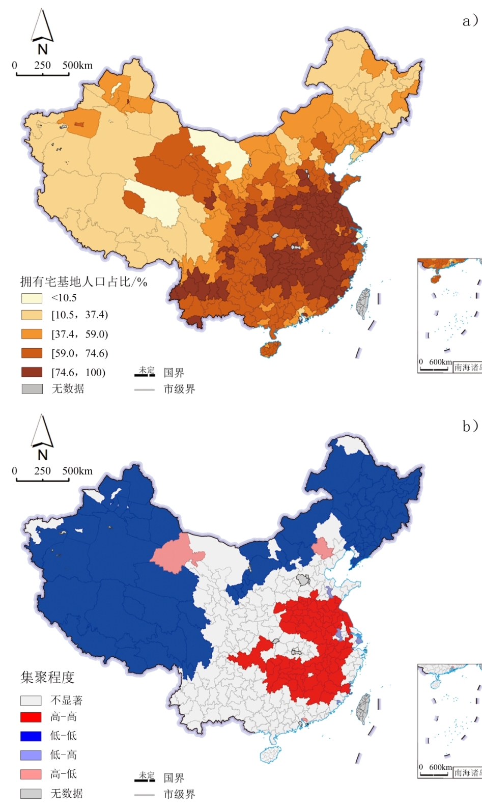
Promoting the orderly settlement of the agricultural transfer population in cities is an important part of citizenship, and it is necessary to analyze the factors influencing the decision of this population to do so. Most existing studies have analyzed an entire region or a particular area, and there is a lack of comparison of the differences in agricultural migrant populations in different outflow areas. In the vast expanse of China, there are significant differences in land resources, economic development, and sociocultural backgrounds among different regions. Therefore, using the 2017 national dynamic monitoring data of the migrant population, spatial autocorrelation analysis, and binary logistic regression models, this study compares spatial characteristics and the influential relationships between the willingness of agricultural migrants to settle in cities and their rural land ownership in China's four major economic subregions. The results are as follows: 1) Ownership of contracted ground has the strongest inhibitory effect on the willingness of the population to settle from the northeast, followed by the east, the west, and the central area. The relationship between rural land size and willingness to settle is negative in both the eastern and northeastern regions—the larger the contracted land size, the weaker the willingness to settle, whereas the opposite is true in the central and western regions. 2) The ownership of homesteads reduces willingness to settle, and homesteads with a smaller-than-average area have a weaker inhibiting effect on willingness to settle than homesteads with a larger-than-average area; however, the degree of the inhibiting effect of residential land on willingness to settle varies by region of outflow. There are differences in the degree of suppression of willingness to settle in different outflow areas, with the effect of having a larger-than-average homestead area being more suppressive of willingness to settle in the central and western regions. Thus, this study finds that rural land resources are an important constraint in the decision to settle, but that there are significant regional differences in the inhibitory effect of agricultural land on settlement behavior. This difference stems from the disparate levels of economic development and urban-rural construction across the country on the one hand, and the differing values of rural land in different socio-cultural contexts on the other. Agricultural migrants constantly weigh the benefits and security of owning rural land and the economic incentives to abandon rural land against the rights and interests of urban hukou. This impacts the rural land and its effect on the willingness of the migrant population to settle in different outflow areas. In the case of contracted ground, the productivity and property value of the land become important tradeoffs for the migrant population in each outflow area. A homestead may be more of a "root" concept and a "home" guarantee that constrains the settlement behavior of the population in different outflow areas. Regional differences in collective dividends also significantly influence the extent of their impact.
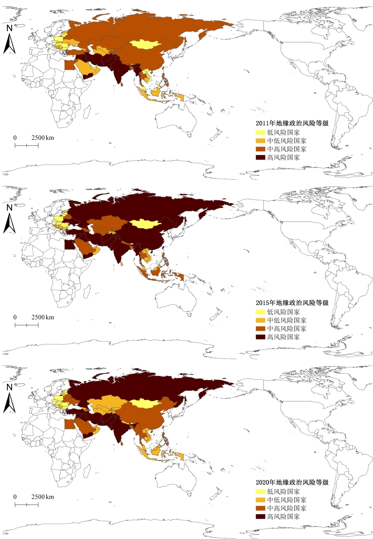
The Belt and Road Initiative aims to achieve common development and prosperity for all countries. Building a scientific and reasonable geopolitical risk assessment system is an important prerequisite for participating countries to prevent and resolve geopolitical risk. Taking 64 countries in the six economic corridors of the Belt and Road Initiative as the assessment object, this study builds a geopolitical risk assessment system based on post-transaction costs. It analyzes the geopolitical risk level, spatial and temporal distribution characteristics, and influencing factors using the full array polygon graphical indicator method, Global Moran's I, and the spatial Durbin model. The research results show that: 1) From the time dimension, the geopolitical risks of participating countries show a trend of first rising and then falling, reaching a peak in 2015. 2) From the perspective of spatial distribution, high-risk areas are mainly concentrated in the Middle East and South Asia, while medium to high risk areas are concentrated in Indochina and the Arabian Peninsula. Most of the low to medium risk countries are Western Pacific island countries, while low-risk countries are mainly in Central Europe. The clustering characteristics of geopolitical risks are obvious. The results of Global Moran's I show that from 2011-2020, the geopolitical risk concentration area was initially located in the Middle East and South Asia, and then in 2015, Europe and East Asia also experienced high geopolitical risks. By 2020, it was still mainly concentrated in the Middle East and Eastern Europe, however, generally, the regions with high geopolitical risk will still be mainly concentrated in the Middle East and Eastern Europe. 3) The research results on the factors influencing geopolitical risks indicate that political stability, economic freedom, economic growth, increased education expenditure, and better natural resources have a significant inhibitory effect on geopolitical risk, while increases in the unemployment rate, population size, and oil resources, will to some extent, promote the generation of geopolitical risks. The indirect effect results show that political stability, economic freedom, and the unemployment rate of the host country have a significant impact on surrounding countries. Based on this, we believe that countries participating in the Belt and Road Initiative need to improve their government governance capabilities, accelerate their modernization transformation, effectively utilize the resources, funds, and technologies brought about by the Belt and Road Initiative. Furthermore, actively integrate into the regional economic cooperation framework of the Belt and Road Initiative and improve their ability to manage geopolitical risks. This study enriched the evaluation system of geopolitical risks. During the construction of the evaluation indicators, the results emphasized the sudden and violent characteristics of geopolitical risks, further explained the violent confrontation and economic game existing in geopolitical risks, and effectively enriched the literature on the spatial characteristics and influencing factors of geopolitical risks of countries participating in the Belt and Road Initiative. It should be pointed out that there are still some limitations in this study. This study is based on countries participating in the Belt and Road Initiative and there are deficiencies in the discussion of geopolitical risk for countries not in the region. Future research can be based on a global perspective, further enriching the evaluation index system of geopolitical risk, and conducting more in-depth research on the spatial transmission path and geopolitical risk avoidance measures.
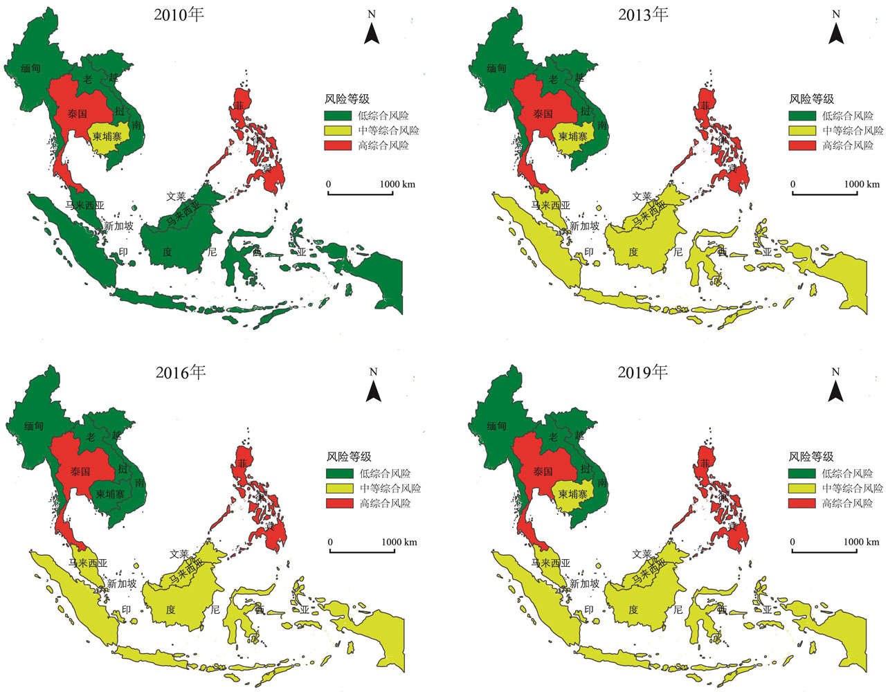
Investment is an important way for regions to optimize their economic structure and participate in globalization. With the evolution of the world's political and economic environment, investment has become an important link to national competition. Including a big power game element is logical to identify investment risks. Simultaneously, in the context of the increasing scale of China's outbound investment, research on investment risk has focused more on identifying the host country's investment environment. In contrast, the impact of significant country-specific competition factors on national investment has yet to be explored. Given this background, this paper adds the concept of geopotential with space power as a measurement factor to the traditional investment environment risk evaluation and establishes a regionally integrated investment risk identification model from the perspective of great power competition. Taking Southeast Asia as an example, we measure the basic investment environment risks of Southeast Asian countries and changes in the geopolitical positions of China and the United States in Southeast Asia. Based on the above, we identify changes in China's investment risks in Southeast Asia in the competition between China and the United States. The results show the following: 1) The basic investment environment risks of Southeast Asian countries show apparent spatial heterogeneity, and the spatial structure is high in the north and low in the south, with Singapore and Malaysia as stable low-risk areas and Myanmar and Laos as stable high-risk areas. 2) The geopolitical positions of China and the United States from 2010 to 2019 show significant regional heterogeneity. The United States has geopolitical advantages in most regions; however, the gap between China and the United States has gradually narrowed. China's geopolitical positions in Myanmar and Laos are ahead of those in the United States. Moreover, the geopolitical positions of China and the United States in Vietnam and Cambodia show intertwined changes. The geopolitical positions of China and the United States in Singapore, the Philippines, Malaysia, Indonesia, Brunei, and Thailand show a parallel evolution. 3) Significant interregional differences in integrated risks based on geographical potential and basic investment environment risks were observed. The spatial distributions of high- and low-integrated risk areas are stable, with Thailand and the Philippines as stable high-risk areas, Myanmar, Laos, and Vietnam as stable low-risk areas, and medium-integrated risk areas showing expansion to the south of the region. 4) According to kernel density estimation, the spatial gap between China's integrated investment risks in Southeast Asia is narrowing, and a non-polarized development of evolutionary characteristics is observed.
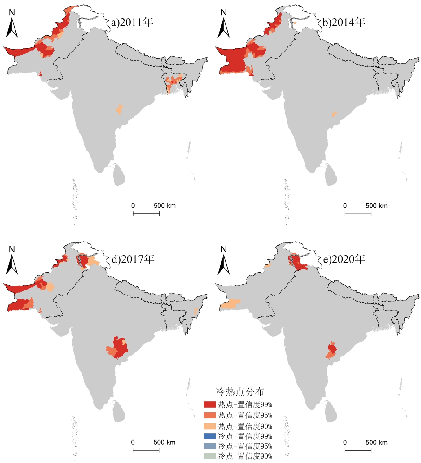
South Asia shares a large territorial border with China, and is the latter's land "position" to enter the Indian Ocean and an important part of the "21st Century Maritime Silk Road." Based on the conflict data in South Asia collected from the Armed Conflict Location and Event Database, the Global Terrorism Database, and the Uppsala Conflict Database, the spatial and temporal changes and intensity distribution of conflicts during 2011-2020 were explored using geostatistical methods such as nuclear density, spatial autocorrelation, and spatial hot spot detection and analysis. The results revealed the following: (1) From 2011 to 2020, the number of conflicts in South Asia increased, but the number of casualties decreased. From the perspective of spatial distribution, regional conflict events are concentrated in the "outer ring of South Asia," and the cluster centers form a "trapezoid" pattern. The Kashmir-Sindh line is a trapezoid at the top bottom, and the Dhaka-Chettisgar-Tamilnad-Colombo line is a trapezoid at the bottom. The conflicts in South Asia exhibit a tendency of similar aggregation, and their distribution is affected by the surrounding region. The secondary administrative regions with positive spatial autocorrelation accounted for about 1/5 of the total, and the aggregate effect of war events was the most significant, andthat of armed conflict events was weak. The distribution of H-H clustering regions for each event type was inconsistent, but L-L clustering regions were mainly distributed in the center of the continent. (2) The distribution range of conflict intensity first increased and then decreased, reaching the maximum in 2017. In Pakistan, there were many areas of conflict intensity distribution, which did not change significantly at the end of the period. In India, the range of conflict intensity distribution first increased and then decreased. The intensity hot spots first spread to Baluchistan, and then shifted to the northeast and southeast, forming two hotspots centered on Kashmir and Chhattisgarh in 2020, with no cold spots. At present, the activities of non-state actors are more fluid and involve more areas, so it is difficult to form new hotspots. Kashmir will remain a hotspot of conflict, and the concentration trend of Chhattisgarh will decline. Baluchistan should be watched closely. (3) The regional conflicts in South Asia are affected by political parties, and power, identity, natural, and other factors. The source of the conflicts is the differences in national identity and religious belief, and they are promoted by state actors, ethnic separatist organizations, religious extremist organizations, and other actors. State factors play a leading role, while the religious and ethnic factors are intractable diseases. The current study has the following limitations. First, this study utilized a large amount of data, with more loyal manual participation in data fusion, cleaning and other work, and there is room for further improvement of accuracy. Second, the driving mechanism of South Asia has not been deeply discussed. The causes of conflicts in South Asia are complicated, and quantitative detection is the next research direction.
The identity construction of a "backpacker" has always been an important topic in research on backpacking. Most current studies analyze the backpacker group as a whole, with insufficient investigation into the differences among different groups. Western scholars found that female and male backpackers had obvious differences in tourism patterns. Considering the different social situations and differences in backpacker' behavior between China and the West, we must examine whether the Western research conclusions are applicable to China. Particularly, married females in China are the core members of the family. Compared with unmarried females, they shoulder more family responsibilities. There is insufficient research on their identity construction as backpackers. This study introduces a married female backpacker's journey through self-ethnography. The study found that parents' travel behavior was the main method of intergenerational transmission of backpacking, and it was also the embodiment of parents' hidden influence on the construction of children's identity. In addition, the will of parents was affected by traditional culture on the cognition of social roles, while the family shouldered the pressure to resist the traditional role concept of society. The disobedience of the owner of the family's power regarding the traditional role norms was a resistance to the traditional power system, which enabled children to break through the social stereotypes and prejudice and practice backpacking. In the traditional family concept, the married female was excluded from backpacking because of their "dependent" role. The path of the married female backpacker ran through the struggle against social role stereotypes, cultural concepts, and consumerism. The research proposed that the breaking of traditional social role cognition and the shaping of new social role characteristics were the important concept origin of the construction of the married female backpacker identity. Meanwhile, it also developed the theory of backpacker identity construction, and argued that the construction of the married female backpacker identity not only occurred in the "difference" against ordinary tourists, but also in the individual's pursuit of self-determination. Through backpacking, in a unique way, the married female could participate in behaviors that reflected their personal interests or values, and had the capability to engage in valuable or challenging behaviors. Thus, they established close ties with others, broke the role shackles under traditional social concepts with their actual behaviors, controlled their travel consumption decisions, integrated into the backpacker group, and shaped new social roles, and then realized the improvement of subjective well-being. Accordingly, modern backpackers are capable of realizing the pursuit of happiness and reflecting on consumerism through self-determination.
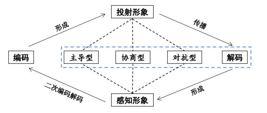
The Maritime Power strategy is of great and far-reaching significance for the high-quality development of China. With the development of this strategy in recent years, academics and the government have been increasingly focusing on marine and national defense issues. It is of great theoretical value and practical significance to clarify the destination images of China's marine national defense tourism and its mode of communication to enhance tourists' national identity. Using data from 15 marine national defense tourist attractions, this study analyzes the official projections and tourist perceptions of marine national defense tourism in China. Key elements were identified using social semantic network and image depth analyses. The Jaccard distance score and Stuart Hall's encoding and decoding theory were applied to explore the internal differences in projections and perceptions in different regions and propagation modes. The results are as follows: (1) China's marine national defense tourism destination images have distinct regional characteristics. The cultural and military images of the northern coastal region were more distinct than the other two regions, the maritime and educational significance of the eastern coastal region was more prominent than the other two regions, and the historical and international characteristics of the southern coastal region were more significant than the other two regions. (2) The projected and perceived destination images of China's marine national defense tourism are focused on tourism. Each scenic spot emphasizes its own social and educational value, while tourists are more impressed by interactive and experiential events than by those ornamental events. 3) The dominant and consultative modes are the main dissemination modes of China's marine national defense tourism destination images, and the dominant mode is mainly embodied in national identity, which is presented through concrete cultural resources, educational activities, and so on. The negotiation model is more significant on tourism activities and tourism infrastructure, while no evident manifestations were observed in the oppositional model. Finally, this study provides recommendations for the construction and promotion of China's marine national defense tourism destination images, such as improving the infrastructure and services to enhance the tourism image, playing an active role in education to strengthen the national identity, broadening the channels of image dissemination, and paying attention to the management of guest-host co-construction.