Coral growth rate is a physical index that is particularly closely associated with climatic factors such as Sea Surface Temperature (SST). The growth rate is minimally affected by environmental changes and serves as a high-resolution indicator in the study of climatic and environmental variation, making it a useful tool in paleoclimatic coral research. However, previous research on coral growth rate has primarily focused on the modern period, with limited investigation of the Mid-Holocene, which shares similar climatic characteristics with the current warm period. It is especially important to understand the climate and environmental conditions during the Mid-Holocene to gain insight into contemporary climate change processes and mechanisms. To address this gap, we first collected a modern Porites coral core and 23 Mid-Holocene subfossil coral cores from Tanmen, located on the eastern coast of Hainan Island. Using X-ray radiography and image processing methods, we measured and analyzed the coral growth rates of all cores, resulting in the identification of growth rate patterns during the Mid-Holocene. Additionally, by analyzing the environmental factors that impact modern coral (2005-2021 AD), we established a linear relationship between coral growth rate (L) and SST in Tanmen, expressed as
The global proliferation of natural predators, including Terpios hoshinota sponge and crown-of-thorns starfish, poses a significant threat to the ecological vitality of coral reefs. However, coral reef research currently lacks comprehensive quantitative studies on the ramifications of predator outbreaks in various coral reef landform types. To bridge this knowledge gap, this study utilized a dataset comprising 26 Sentinel-2 remote sensing images spanning the years 2016 to 2022, both pre- and post-two distinct episodes of natural predator outbreaks involving the Terpios hoshinota sponge and crown-of-thorns starfish, within the vicinity of Taiping Island. High-resolution GF-2 (PMS) remote-sensing images and satellite data were used to augment the analysis. Based on data obtained from the Google Earth platform of the Geographic Information System for remote sensing imagery, we conducted an experiment involving the classification of coral reef landform types in Taiping Island in the South China Sea. During the Support Vector Machine (SVM) classification experiments, we performed a meticulous examination of the image interpretation outcomes, making comparisons and rectifications in consultation with domain experts. Classification was performed by analyzing remote sensing images, and the identified landform types included areas characterized by dense coral sedimentation, sparse coral sedimentation, coral clusters, sand flats, and shallow reef front slopes. Subsequent analyses focused on discerning distinctive characteristics and tracing their evolutionary patterns. The findings reveal that (1) this study effectively integrates expert interpretation knowledge and an SVM classification algorithm to classify the various landform types present in Taiping Island's coral reef ecosystem. Remarkably, the classification achieved an unprecedented level of accuracy, with an overall accuracy rate of 96.46% and a kappa coefficient of 0.94. (2) The analysis showed that during the two natural predator outbreaks, the coral reef landforms on Taiping Island, which included dense coral reef areas, dense coral sedimentation areas, and sparse coral sedimentation areas, displayed significant decreases in their respective areas. The outbreak of Terpios hoshinota sponge had the most profound impact on the dense coral sedimentation area, resulting in a 72.92% decrease in the total area. Meanwhile, the outbreak of crown-of-thorns starfish had the most significant effect on the coral cluster area, causing a 59.17% reduction in total area. (3) Over the period spanning from 2016 to 2022, the degradation rate of the coral reefs on Taiping Island exceeded the recovery rate. Notably, the highest degradation rate (23.88%) occurred between March-June 2017. Conversely, the highest rate of recovery (18.03%) was observed from June-September 2017. We analyzed the dynamic characteristics of coral reef landform types, including changes in type distribution, areal extent, degradation rate, and recovery rate. Furthermore, we assessed the influence of natural disturbances on the degradation of coral reef ecosystems, thereby providing valuable insights for conservation and scientific inquiries pertaining to coral reef ecological resources in the waters surrounding Taiping Island. This effort is underpinned by a solid theoretical foundation. The Chinese and English literature cited in this article have contributed significantly to various facets, including coral reef monitoring methodologies, construction of coral reef classification systems, and assessment of coral reef ecosystem health.
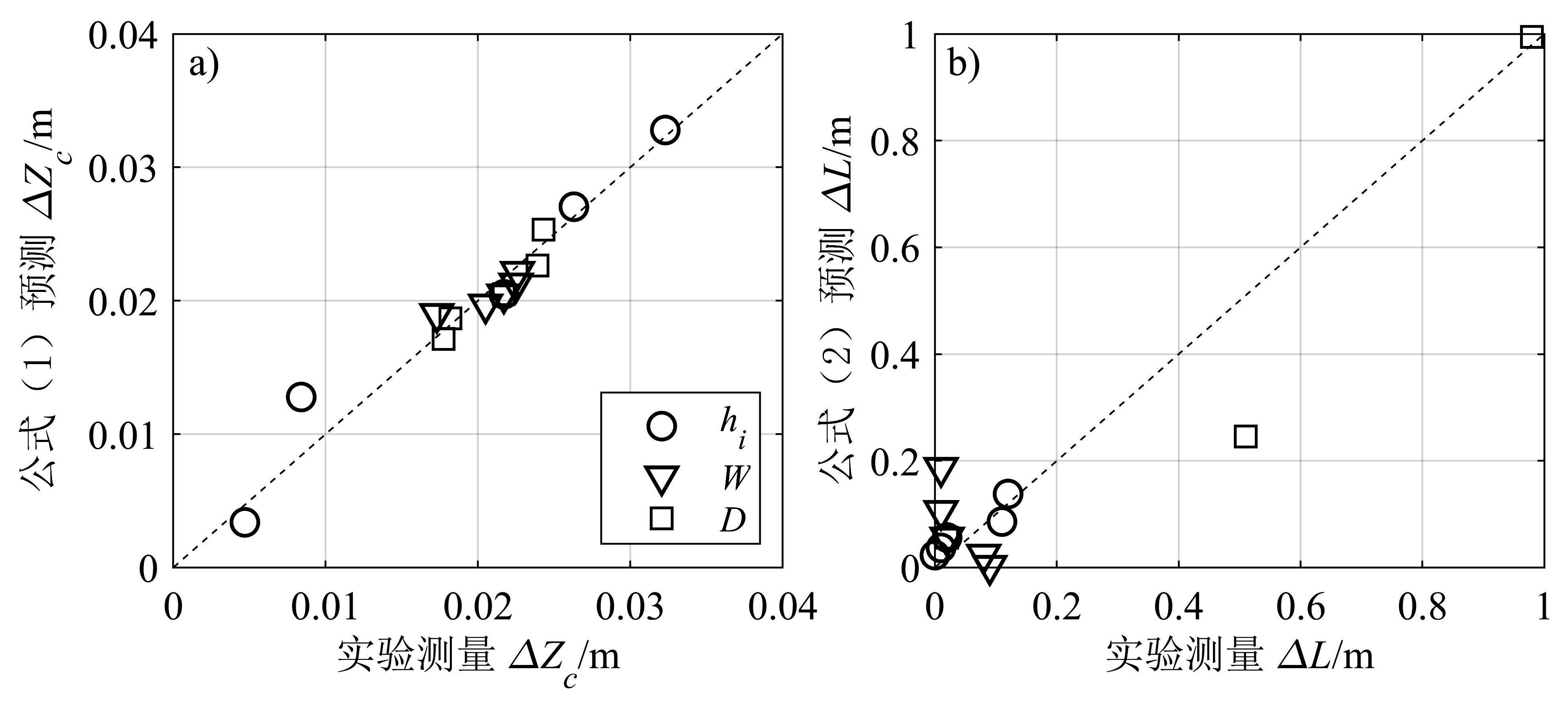
Reef islands are composed of unconsolidated carbonate sediment from the reef that has been organized and deposited on an atoll and platform reef by ocean hydrodynamics. They are frequently found in remote mid-ocean locations within tropical and subtropical waters and are the sole source for habitable land of some island nations. It is anticipated that sea level rise and more frequent and intense storms resulting from global climate change will destabilize these low-lying reef islands, thus there is increasing concern about the persistence and habitability of these islands during future extreme wave events. The reef island morphodynamic response to the action of regular waves has not been reported in the literature. Therefore, this study performed laboratory experiments based on a horizontally one-dimensional reef island physical model in a wave flume. The temporal variation of the island profile under regular waves was measured to analyze the effects of island morphological factors (initial island height and width) and initial island location on its topographic evolution. The results showed that the reef island lost crest elevation and migrated and extended toward its lagoon side under the action of regular waves. Accretion also occurred on the lagoon side beach and random ripples appeared. The time required for the island to reach its equilibrium profile decreased with increasing of initial island height, initial island width, and initial island distance from reef edge. The island crest lowering due to scouring increased with increase of initial island height, but it decreased with increasing of initial island width and initial island distance from the reef edge. Among the three factors, initial island height had the greatest impact on the crest lowering. The island lagoonward migration decreased with increasing of both initial island height and initial island distance from reef edge, but it increased with the increase of initial island width. Among the three factors, initial island location was the most influential factor to lagoonward migration, but no island lagoonward migration was detected when the initial island distance D≥2 m. Regression analysis was used to obtain empirical formulae to predict the island crest lowering and island lagoonward migration, respectively. The outcomes of this study provide a habitability assessment for such low-lying island nations in the context of global climate change.
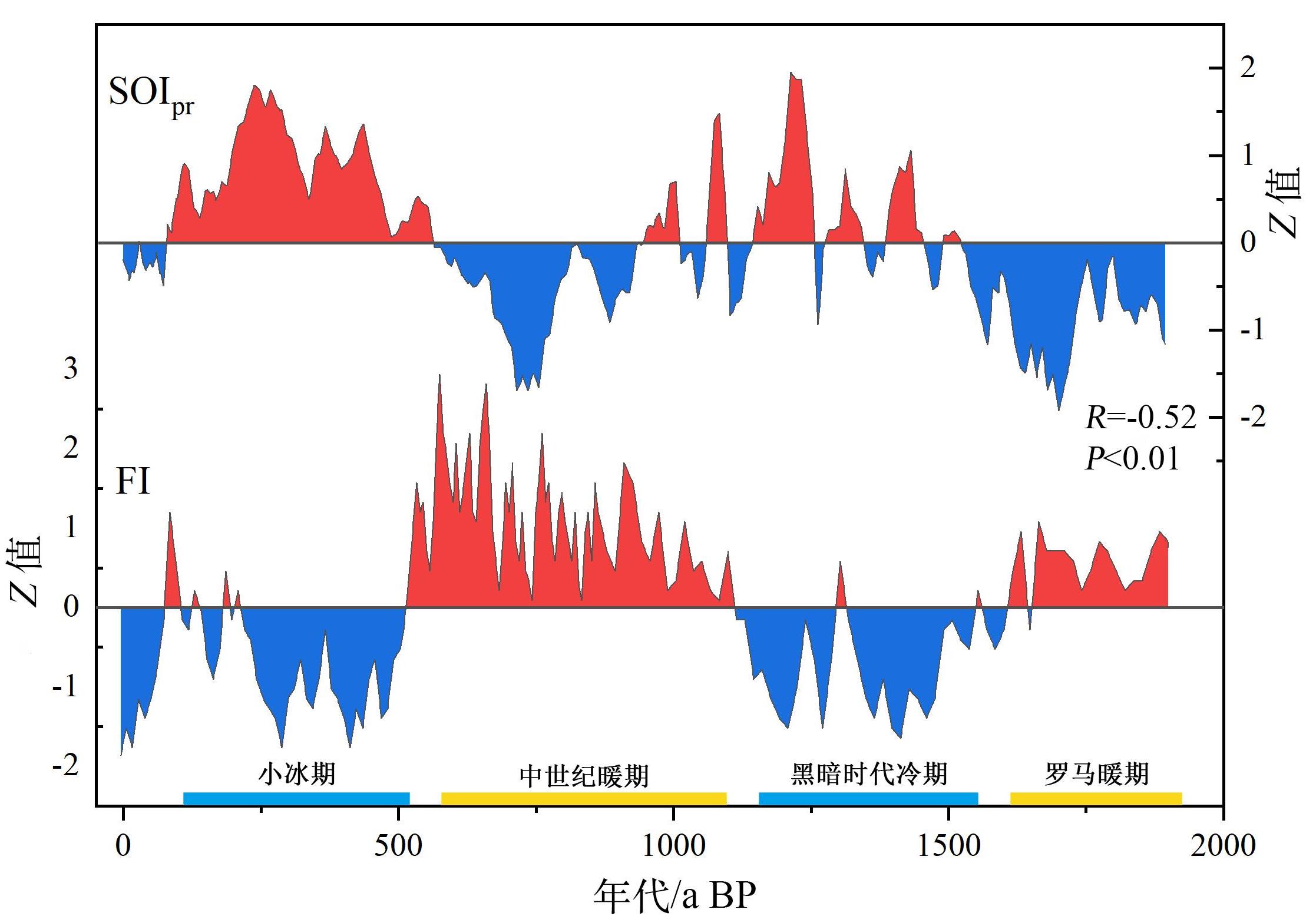
The Foram Index (FI) is used to evaluate the ecological health of coral reef areas based on the content of benthic foraminifer functional groups (symbiont-bearing, opportunistic, heterotrophic) in the sediments of coral reef areas. Thus far, the application of the FI in China remains limited. In this study, an LYJ2 sediment core, 287 cm in length, which is estimated to represent approximately 2,665 years before present (a BP), was obtained from the lagoon of the Lingyang Reef on the Xisha Islands. Samples were taken at intervals of 0.5 cm to identify the foraminifera under a microscope, and the FI values were calculated. The key results are as follows. 1) the FI in the last 2,600 years ranges from 4.1 to 7.9, mean value of 5.9. 2) FI values show a fluctuating pattern, which can be divided into three periods of increased abundance: 2,380?1,628, 1212?572, and 252?92 a BP; three periods of rapid decline: 1,628?1,212, 572?252, and 92 a BP; and one period of moderate decline: 2,665?2,380 a BP. 3) FI exhibits interdecadal fluctuations at different scales, with cycle of 66.7 and 54.4 a. Based on the relationship between the FI values and the health status of coral reefs, we speculate that the ecological environment of the Xisha Lingyang Reef has been generally healthy for the past 2,600 years. Based on a comparative analysis of the FI and sea surface temperature, it appears that FI is mainly affected by sea surface temperature, which, in turn, is related to climate change. A high FI roughly corresponds to the Medieval Warm Period and Roman Warm Period, and a low FI roughly corresponds to the Little Ice Age (LIA) and Dark Age Cold Period (DACP). The FI values exhibit three stages of rapid decline. The first two (1,628?1,404 and 572?252 a BP) correspond to LIA and DACP, respectively, which may be due to the increase in atmospheric dust, rainfall, and nutrients in the waters of Lingyang Reef caused by the enhancement of the winter monsoon in the cold period. The later period (92 a BP to date) corresponds to the rapid degradation of coral reef ecosystems in the Xisha Islands in recent decades, possibly due to increased nutrient concentrations in the Antelope Reef Sea area caused by increased human activity and atmospheric nitrogen deposition fluxes. Studies have shown that FI can generally record the health status of coral reefs in the South China Sea and can be used to evaluate the health status of coral reefs in geological history.
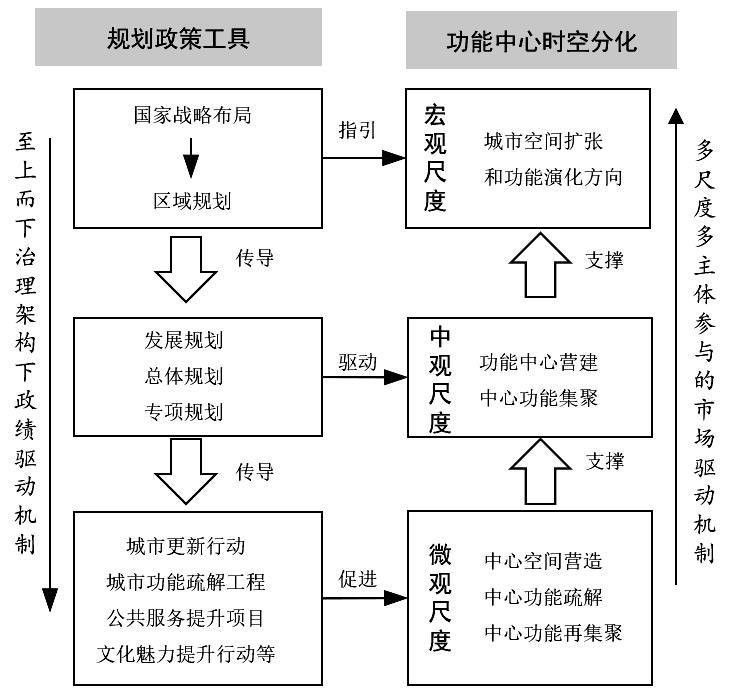
Knowledge of the evolutionary characteristics of urban functional centers and their formation mechanisms is a prerequisite for promoting urban renewal and optimizing these centers. Taking the central urban area of Suzhou as an example, the driving mechanisms of spatial-temporal differentiation were determined through examining long-term data of urban points of interest, kernel density estimation, and location entropy. The findings are as follows. First, the spatial distribution of urban functional centers evolves from a monocentric to a polycentric pattern, with a significant pattern of primary and secondary differential order. In the case of Suzhou, the city has evolved from a single center to a multi-center functional system with one main center and four sub-centers, which is in accordance with the layout of the functional centers determined by the urban master plan. Second, The services of functional centers shift from public function to a dominance of lifestyle function and then to consumer dominance, which supports the trend of the transformation into a consumption-oriented city. The spatial differentiation of the dominant function types of each center is significant, with both a complementary division of labor and a corresponding trend of functional specialization. Under China's unique governance system, the intervention of planning policies is bound to have a significant impact on the spatial and temporal differentiation of urban functional centers. Therefore, based on the perspective of urban planning and policy, we have constructed an analytical framework for the evolution of functional centers at multiple scales and with multiple actors acting together. Macro policies are transmitted downward through national strategies and regional plans to guide the overall evolution of space and functions; at the meso policy level, the active local government builds a blueprint plan through planning tools, such as development plans and urban master plans, links with market mechanisms, and carries out urban management to promote the generation of multiple functional centers in the city. At the micro-policy level, action policies such as urban function relocation, spatial regeneration, and the creation of special spaces in new towns are coordinated to promote the function relocation and agglomeration of functional centers in the city. Multi-scale planning policies jointly construct a nested mechanism to drive the evolution of functional centers; however, the degree of spatial and temporal matching between planning policies and market mechanisms determines the formation and evolution paths of functional centers. The mismatch between the "blueprint" approach of urban planning and the flexibility of the market mechanism, the failure of the transmission of planning policies at the upper and lower levels, or the change of planning can cause a bias in the generation and evolution of functional centers. The contribution of this study is, first, to establish a spatial and temporal cognitive framework for the evolution of functional centers and to explore the evolutionary pattern of the dominant function types of functional centers based on fine-grained data. We found that the dominant functions of urban functional centers in the case study area go through an evolutionary process of "public function-living function-consumption function". A similar process has not yet been documented in other cities, underscoring the need to verify the model through multi-case comparisons. Second, the special urban governance environment in China requires that researchers and planners view policy interventions at multiple scales in order to fully understand the spatial and temporal evolution of urban functional centers and so establish a policy cognitive framework for the evolution of functional centers. Understanding the role of planning policy interventions forms the basis for the subsequent implementation of targeted planning interventions.
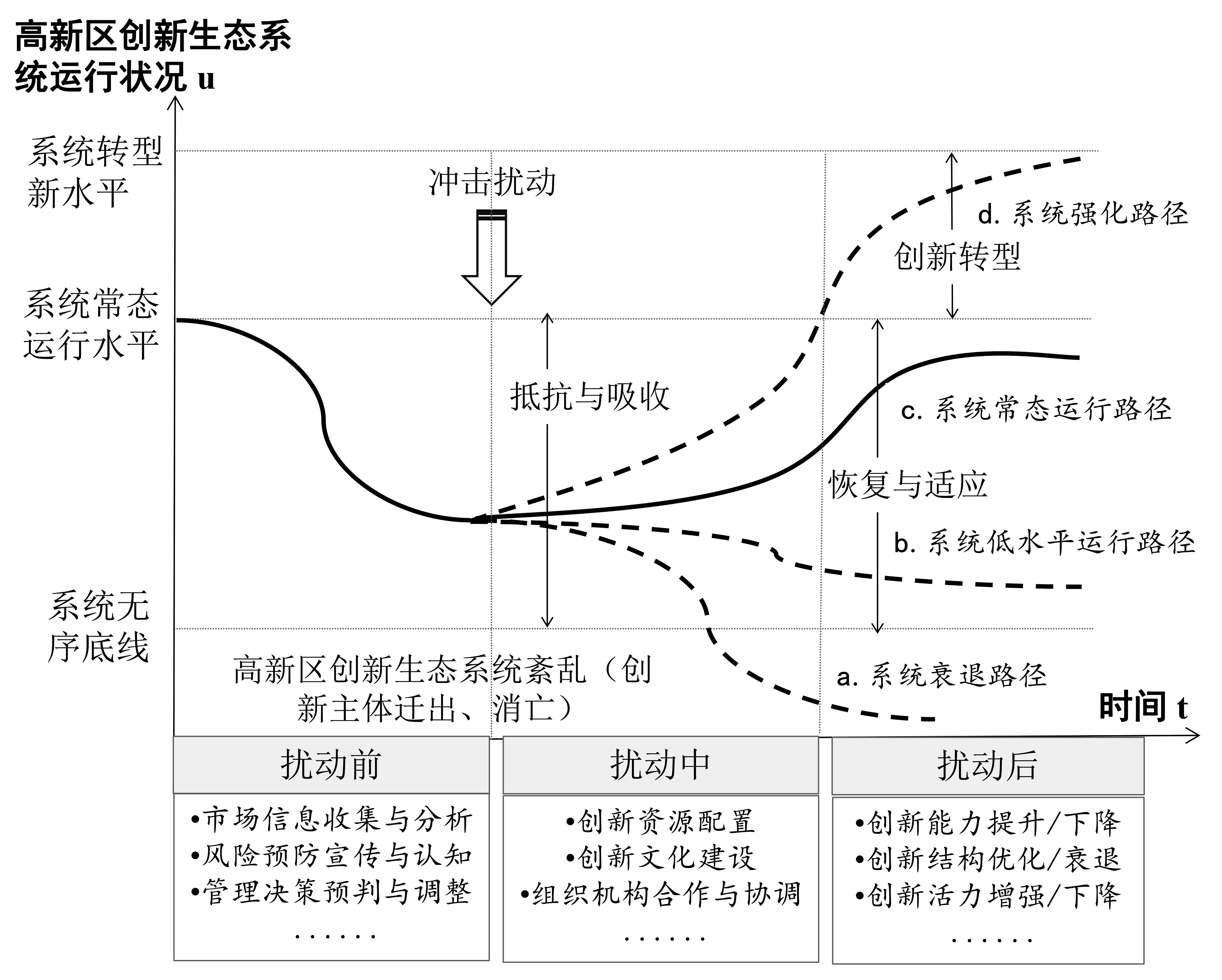
At present, the economy of China is in a new stage, shifting from high-speed growth to high-quality development. Accordingly, high-tech industrial development zones (hereinafter referred to as "high-tech zones") have developed as clusters of innovative resources, high-tech enterprises, and industries. These high-tech zones serve as demonstration zones for national and regional innovation development. Building a resilient innovation ecosystem in high-tech zones and enhancing their ability to cope and adapt to an uncertain environment are important for promoting the high-quality development of these zones as well as the regional economy. There are few academic studies on the resilience of innovation ecosystems in high-tech zones. Incorporating the concept of resilience and enhancing the ability of innovation ecosystems in high-tech zones to cope with risk is a topic worthy of attention in academic research. Here we introduce the concept of resilience, explore the connotation and characteristics of the resilience of the innovation ecosystem in the high-tech zone, analyze its evolution process by applying adaptive cycle theory, and construct a measurement index system in four dimensions: resistance, absorption, recovery, and transformation power. From this perspective, resilience is considered the ability of the zone to maintain and restore its original characteristics and functions and also to continue to grow after the system has been disturbed. The zone characteristics considered are complexity, dynamic evolution, scale correlation, and regulation, as evident through four evolutionary stages: exploitation, storage, release, and renewal. Using the TOPSIS method, 46 high-tech zones in Hunan Province were selected as research objects, and their innovation ecosystem resilience levels and spatiotemporal pattern characteristics were analyzed. It was found that the innovation ecosystem resilience level of the Hunan high-tech zone increased from 0.316 in 2012 to 0.604 in 2020, showing an overall upward trend in resilience. In terms of the increase in the level of resilience in each dimension, the most significant increase was that of transformation power, followed by absorption and resistance powers. The smallest increase was that of recovery power. The spatial pattern showed obvious divergence, with the more resilient high-tech zones clustered in the Changsha-Zhuzhou-Xiangtan urban agglomeration and the less resilient zones distributed in the western Hunan region. Over time, the degree of spatial differentiation gradually shrank, forming the characteristics of a highly resilient agglomeration, with the Changsha-Zhuzhou-Xiangtan urban agglomeration as the core, and Yueyang, Chenzhou, Changde, and other multi-centers coexisting. In this study the innovation ecosystem of high-tech zones was examined from the perspective of dynamic development; the results are expected to broaden the concept of urban development resilience in theory and promote the high-quality development of high-tech zones in practice.
With the rapid development of lifestyle logistics in the service industry, such as e-commerce express and same-city delivery, new challenges have arisen in the planning and implementation of urban logistics freight and related industries. However, studies of existing urban logistics tend to focus on large-scale administrative areas, such as inter-provincial and city clusters, ignoring the importance of intra-city logistics networks. Traditional research methods are mostly based on static data to simulate inter-city logistics links, which makes it difficult to accurately and comprehensively reflect the intra-city logistics factor flows and their linkages. In response to these shortcomings, we adopted a method to track logistics in real time, by using truck GPS "flow data" across the city of Shenzhen. In addition, a community discovery model based on social networks was developed to identify important intra-city logistics nodes. The following conclusions are drawn. 1) There are 12 logistics hub nodes in Shenzhen, including the Songgang Industrial Zone, Yantian Port, and Pinghu Logistics Park, based on the infrastructure of large industrial clusters, advanced technology industrial zones, and integrated logistics parks. 2) Intra-city logistics activities are mainly concentrated on weekdays; in contrast, on weekends, logistics activities are severely inhibited by factors such as frequent activities of residents during holidays and delayed construction of planned roads. 3) The overall internal logistics linkage is weak, with logistics activities concentrated in the Guangzhou-Shenzhen axis, showing a spatial pattern of "dense in the west and sparse in the east", but the existing logistics infrastructure is mostly located in the central part of the city, which results in a misaligned layout of logistics activities heading west and logistics facilities being distributed in the middle. 4) The logistics linkage feature "heterogeneous attraction" is obvious: the logistics activities of different types of nodes tend to flow towards specific areas, gradually forming a logistics corridor with "airport-industrial area-coastal port-logistics park" as the axis. Intra-city logistics relies on the linkage of the corridor and forms a logistics corridor network model, with the corridor as the axis spreading to the periphery. 5) The intra-city logistics spatial organization can be divided into six subgroups, whose edge subgroups basically transfer logistics activities around the core subgroups, constituting a "core-edge" organization pattern. Taking these key results into consideration, we propose planning for high-quality development of intra-city logistics in Shenzhen, from three perspectives: reshaping the logistics space, adjusting planning, and cultivating new growth levels. The results of this study not only help to develop and improve the theoretical and methodological system of urban logistics network and deepen the understanding of intra-city logistics network construction, but also serve as a 'Shenzhen sample' for urban logistics development, with the goal of integrating Shenzhen into the world-class logistics hub of Guangdong-Hong Kong-Macao Greater Bay Area.
After years of high-speed urbanization and rapid expansion, China's economy has gradually transformed into a "new normal," with a new people-oriented urbanization strategy emphasizing spatial quality. In this context, the disjunction between the development of medium- and high-density buildings and low-density human activity, common in the new towns and districts of China, has become increasingly prominent. From the perspective of spatial form, this study proposes that good street accessibility, suitable construction density and architectural form, and sufficient functional mixing are the bases for promoting sustainable urban development. In these studies, the spatial form elements in Yinzhou New Town in Ningbo were measured using spatial syntax, spatial matrix, and mixed function indicators. The results show that (1) the overall coordination ability of the street network in Yinzhou New Town is strong, the local spatial network and global spatial network structure are integrated, and the vitality of the street system in the central area is relatively high; (2) the architectural forms of Yinzhou New City are mainly middle-level slabs and enclosures, low-level enclosures, and high-level slabs. Analysis of density-shape correlation reveals residential areas within the low-level high coverage zones and shielded residential areas in the multi-level high coverage zones, suggesting a need to appropriately enrich multilevel slab or enclosure and high-level enclosure zones, which have strong positive effects on the vitality of New City; (3) The new urban area of Yinzhou is dominated by the single-function large-scale land development mode, with a low proportion of mixed land and only 1.73% thoroughly mixed land (H_A_W); (4) Functional mixing, accessibility, building strength, and form have a high degree of overlap. A total of 64.54% of cells with a high floor area ratio (> 2.2) were clustered in high-accessibility areas, and 50.25% and 85.71% of dual-function and multi-function mixed units, respectively, were clustered in high-accessibility areas. The effect of the mixed function-accessibility association is more obvious when mixed units include public facilities. In the future, the spatial structure represented by street accessibility should be considered the core breakthrough point. On the one hand, we should ensure good street accessibility as a whole; on the other hand, we should organize the arrangement of construction intensity and functions with high accessibility street distribution, emphasize the moderate mixing of urban land, construct diversified urban life, and improve the vitality and sustainability of urban space to simultaneously realize an agglomeration of multiple urban morphological characteristics with positive effects, and finally foster the emergence of urban spaces with high urban vitality. These sustainable spatial form investigation results are helpful for formulating policy suggestions to improve the quality of ecologically sound construction and create spatial vitality through informed planning and design.
The urban-rural relationship in China has undergone distinct stages, broadly categorized as follows: coordinated development and rural-urban integration. During the initial phase of rural-urban integration, certain townships pursued collaboration with cities possessing high-scale functional zones, aiming to gain increased autonomy in economic management. This approach facilitated the expansion of high-scale functional zones from cities to rural regions. The evolving urban-rural relationship in China has led to an intricate socio-spatial structure characterized by an overlap of high- and low-scale functional zones, forming an embedded complex. Although the TPSN (Territory-Place-Scale-Network) model offers a valuable framework for describing the changing dimensions of this structure, it fails to explain the causative factors behind these changes or accurately delineate the process of such transformations. Hence, we employed the ASID (Agency-Structure-Institution-Discourse) framework as an analytical tool to examine the two stages of the Guangzhou-Qingyuan Economic Special Cooperation Zone (GQESCZ) as a case study. Results of this study revealed that GQESCZ exhibited a pronounced embedded complex. The high-scale Guangzhou Development Zone (a national-level economic development zone) is nested within several township-level administrative regions of Qingyuan. In the first stage of GQESCZ, Qingyuan, serving as a superior government to Yingde, operated as a local leader, akin to the roles played by Foshan and Guangdong. Its objective was to facilitate the development of a cooperation zone and enhance regional public interests. However, during the second stage of GQESCZ, both Qingyuan and Guangzhou took on the roles of institutional actors and underwent significant identity changes. Qingyuan exhibited varying actor roles throughout different stages of urban-rural integration, emphasizing how actor categories evolved in line with their objectives. The various actor categories involved in spatial production served as strategic tools for achieving their respective objectives. Also, we found that hegemonic discourse generated a heightened sense of political responsibility within the Guangdong provincial government, thus elevating expectations for urban-rural integration projects. To meet these provincial government aspirations, both Guangzhou and Qingyuan opted to undertake urban-rural integration projects in well-established industrial parks. To mitigate the risk of project failure, the Guangdong provincial government has delegated significant authority to the municipal governments responsible for these projects. This delegation allocated responsibilities and powers between the provincial and municipal levels. Provincial governments simultaneously transferred both power and responsibility to local governments, aiming to minimize the accountability risks associated with these projects. Furthermore, this approach provided substantial authorization, enabling local governments to execute urban-rural integration projects to high standards. Importantly, during the formation of the embedded complex in GQESCZ, both the Guangdong provincial and local governments displayed a clear preference for blame-avoidance. An effective role is never played by specific socio-spatial forms but rather by social actors who are embedded within and utilize these spatial forms. This realization emphasizes that, in the study of social spatial theory, the significance of a specific socio-spatial form can only be assessed from the perspective of the participating actors. This study analyzed the production process of social space from the perspective of the local government's blame-avoidance preference, thus bridging the gap between socio-spatial theory and blame-avoidance game theory. Findings of this study indicate the importance of fostering diverse forms of intercity cooperation, thereby capitalizing on the adaptability offered by flexible spatial delineation methods, such as embedded complexes. This approach facilitates the expansion of cross-boundary governance overseen by core city governments and supports the re-territorialization of urban capital. Simultaneously, it is crucial to proactively employ rigid measures, such as administrative division adjustments, to safeguard the accomplishments of institutional reforms stemming from embedded complexes.
Industrial coordination constitutes a crucial aspect of regional integration, and evaluation of industrial collaboration holds significant practical importance in elucidating industrial processes and advancing industrial development. In this study, a variety of data sources, including enterprise big data and mobile signaling data, were used to construct an evaluation framework for assessing regional collaborative development of intercity industry clusters across two dimensions: latent associations and actual associations. Incorporating factors such as the industrial chain, industrial homogenization, capital, and personnel mobility into a unified framework to assess industrial collaboration, we comprehensively explored collaborative relationships within the electronic information industry in the Pearl River Delta. The Following results were obtained: 1) The Pearl River Delta city cluster, with Shenzhen, Dongguan, and Guangzhou as its core, has established a highly integrated network within the next-generation electronic information industry chain. Examining latent associations reveals a significant level of specialization, particularly within individual metropolitan areas. When considering actual associations, core cities demonstrate close interactions in financial interactions, and strong interconnectedness is also apparent when commuting between these metropolitan areas. 2) Notable collaborative development is evident within the Pearl River Delta's new-generation electronic information industry cluster, particularly involving Shenzhen and Dongguan, Shenzhen and Guangzhou, Zhuhai and Zhongshan, and Zhongshan and Jiangmen. Of particular interest is the strong differentiated cooperation between Shenzhen and Dongguan. While collaboration among core cities is robust, there is room for improvement in collaboration levels that include peripheral cities,and we suggest maximizing the central leadership roles of Shenzhen, Dongguan, and Guangzhou to nurture diverse industrial clusters in peripheral cities. Our evaluation system proposed our article can be used to measure the collaborative development of intercity industry clusters. It aids in urban planning and policymaking, promotes sustainable economic growth in the region, and offers reference and insights for the industrial collaborative development of other city clusters.
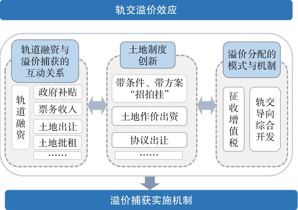
To improve the effectiveness of urban planning, the effect of rail-transit construction on the value of residential projects along rail-transit lines should be assessed. In studies to date, the focus has been on the effects of various urban development elements on housing prices in rail transit station areas; however, there are few studies of the premium effects and value-capture mechanisms in rail transit station areas. In this study, the average price of a residence in existing residential neighborhoods in Hefei, using data published on the Anjuke website in December 2018, was used in an assessment of the value added of the Hefei Metro Line 1. The data included the name of the community, average price per unit area, location, housing age, floor area ratio, and greenery rate. Baidu POI data from December 2018 were used to determine bus routes and various public service facilities in the district. First, we constructed a housing price fitting model in the station area and analyzed the spatial value-added pattern of housing and the premium effectiveness of each fitting index. From this analysis we extracted the premium characteristics of housing projects in the station area and then determined the value capture mechanism and proposed optimization strategies. The results indicate the following: (1) The impact of Hefei Metro Line 1 on housing prices along the line is significant and decays with increasing distance from the rail transit station. (2) Different index elements have different effects on station-area residential premiums. The location and transportation level indicators contribute the most to the premium, followed by the neighborhood and environment level indicators. In contrast, the building form level indicators contribute the least to housing prices in this model. Specifically, the distance between the residential community and the rail station, as well as the distance between the residential community and the CBD, produce a significant negative price premium that decays with distance. Other indicators―housing age and presence of amenities such as hospitals, shopping malls, and museums―also have significant negative linear premium effect. The number of bus lines, as well as the greenery rate and presence of parks had significant positive linear premium effects. (3) Based on the model score results, quadratic groups were constructed to evaluate the station area, and the premium rule and geographical effect of the station area was established. The systematic connection between the premium effect and the value capture of the rail transit station area can be identified, the distribution characteristics of the housing price of the station area can be accurately identified, and the current differences in the degree of residential premium in the station area can be indicated. Furthermore, based on the case of the Hefei metro area, the interaction between rail transit financing and value capture was analyzed for its applicability to China's public ownership land system. Accordingly, a land use strategy with institutional feasibility is proposed, and different models and implementation mechanisms of premium allocation are suggested, which are of great importance in terms of promoting the return of rail transit premiums to the public, the sharing of land benefits among urban residents, and, ultimately, sustainable social and economic development.
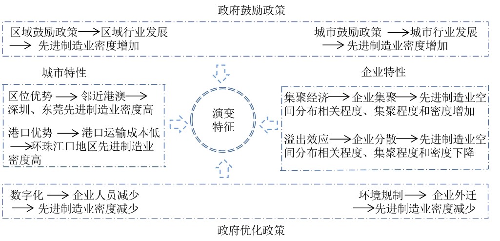
Since the 2008 global financial crisis, the United States, Britain, Germany, and other developed Western countries have regarded manufacturing as a driving force for economic revitalization. The United States proposed the concept of advanced manufacturing and issued a series of policies to ensure its leading position in the manufacturing industry by promoting the development of advanced manufacturing. Advanced manufacturing is the only way for China to move from a large manufacturing country to a powerful manufacturing country, and it is also the direction of manufacturing development. Therefore, it has received great interest from officials and academics. However, as it is difficult to define the categories of advanced manufacturing in national statistical standards, only a few studies have focused on the definition and policies of advanced manufacturing and a case study on the spatial-temporal patterns at the urban level under the influence of local policies. There have been no studies on the spatial-temporal pattern of advanced manufacturing at the regional level and its influencing factors to promote the development of regional advanced manufacturing clusters. The spatial-temporal patterns of the advanced manufacturing distribution at the regional level are not only affected by local policies, but also related to the characteristics of each city within the region and the agglomeration and spillover characteristics of enterprises between different cities. How these factors affect the regional level of advanced manufacturing distribution and the spatial-temporal characteristics warrants further research. Based on four sets of economic census employment data at the district-level in 2004, 2008, 2013, 2018, this study uses the density, growth rate, Theil index, and Global Moran's Index to explore the spatial-temporal pattern of advanced manufacturing distribution in the Pearl River Delta and its influence factors. It found that (1) the density around the Pearl River area and the east bank is higher than that of the peripheral area and the west bank, but the growth rate of four parts is similar during the whole period and it appear negative during between 2014 and 2018. (2) the density of nine cities in order are: Shenzhen> Dongguan> Zhongshan> Foshan> Zhuhai> Guangzhou> Huizhou> Jiangmen> Zhaoqing; the growth rate of nine cities are: Zhaoqing> Huizhou> Shenzhen> Foshan> Zhuhai> Zhongshan> Dongguan> Guangzhou> Jiangmen, and that of Shenzhen, Foshan, Zhongshan, Dongguan and Guangzhou is negative between 2014 and 2018. (3)spatial distribution evolves from "core-multiple edges" to "core-multiple subcores-multiple edge", the density of Guangzhou and Shenzhen appears suburbanization, density of districts becomes higher, growth rate of districts gets lower and that of 84% districts are negative between 2014 and 2018, Global Moran's Index is high but decreasing, Theil Index is above-moderate and increasing. Government encouragement policies of regions and cities, urban characteristics of location advantage and port advantage, and enterprise characteristics of agglomeration economy promote advanced manufacturing agglomeration, increased density, high spatial distribution, and multiple core emergence; The government optimization policies of digitalization and environmental regulation, and the enterprise characteristics of spillover effects lead to the suburbanization of big cities, the negative growth of the Pearl River Delta region from 2014 to 2018, and the decreasing trend of spatial distribution correlation. This study focuses on the spatial-temporal patterns of advanced manufacturing distribution representing the development direction of manufacturing and its influencing factors in the Pearl River Delta to provide a reference for government decision-making at all levels in the Pearl River Delta, to formulate policies to promote the development of advanced manufacturing, enhance the economic strength of the Pearl River Delta, and realize China's dream of becoming a powerful manufacturing country.
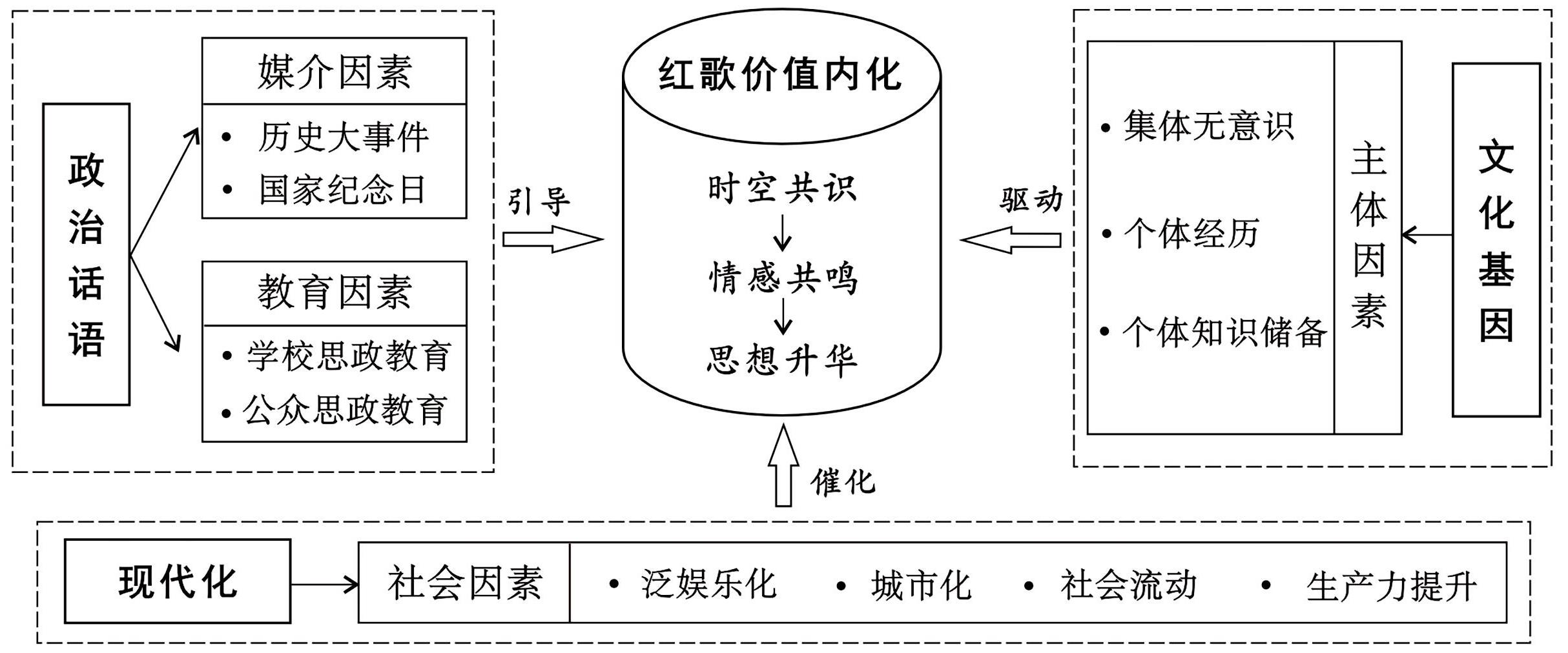
"Red songs" record the stories of family and country in a specific time and space and are grand narratives that spread the spirit of the Chinese nation, build collective memory, and trigger emotional resonance. Based on humanistic epistemology, this study constructs a theoretical framework for the interpretation of spatio-temporal narratives of texts. The text of red songs and the network hot comments are selected as the research objects. From the narrative perspective of chronological order and spatial structure, grounded theory, natural language processing method, and the Latent Dirichlet Allocation (LDA) model are adopted to explore the spatial and temporal meaning construction of the grand narrative under the scale of the family and the country. Additionally, the study investigates the internalization of the value mechanism of the emotional arousal and output of the creators of the text and the audience across the space and time is also investigated. The results reveal the following: (1) Red song lyrics can be categorized into four dimensions: time, space, memory, and spirit. The spatio-temporal performance of the red songs can be recognized as the stories of the family and the country that occurred in different spatial scales, such as body, place and region, during the periods of the New Democratic Revolution, socialist construction, reform and opening up, and the new era. This resulted in a condensing of the spatio-temporal course of revolution, resistance, liberation, struggle, and rejuvenation of the Chinese nation over the past hundred years. (2) The spatio-temporal dimension records the main vein of collective spatial practice and becomes the basic element of representation. The memory and spiritual dimensions are the core meaning of the representation, demonstrating that the spatio-temporal factor carries the national memory through the collective practice and metaphorically represents the spirit of resistance and struggle. (3) The red songs network hot comments are closely integrated with the four dimensions of the narrative text, presenting the audience's reception of the information transmitted by each dimension of the text and the internalization of values in the spiritual realm. Value internalization is manifested in a series of processes such as the reception, comparison, superposition, reconstruction, and sublimation of multidimensional information by the audience. This realizes the transmission and interaction of emotions across time and space between the text's creator and the reader, leading to construction of thoughts and consciousness aligned with the mainstream societal values. (4) The mechanism of value internalization is a chain reaction of political discourse, cultural genes, and modernity acting together in the media, education, subject, and society. Among these, political discourse is the guide, cultural genes are the driver, and modernity is the catalyst. The study of spatio-temporal interpretation of the red song lyrics is not limited to the objective existence attributes of spatio-temporal, but takes this as the starting point to explore the meaning creation of this on the grand narrative text, as well as the internalization mechanism of textual value under the spatio-temporal transformation, which is conducive to the expansion of new cultural geography's research on the interpretation of spatio-temporal narratives in texts. In addition, the study expands the research logic of spatio-temporal identification to the intrinsic connection between spatio-temporal and human subjects from the three aspects of manifestation, representation, and representation effect. This enriches the theoretical system of spatio-temporal narrative to a certain extent and provides theoretical support for the exploration of the spatio-temporal-based path of textual analysis.
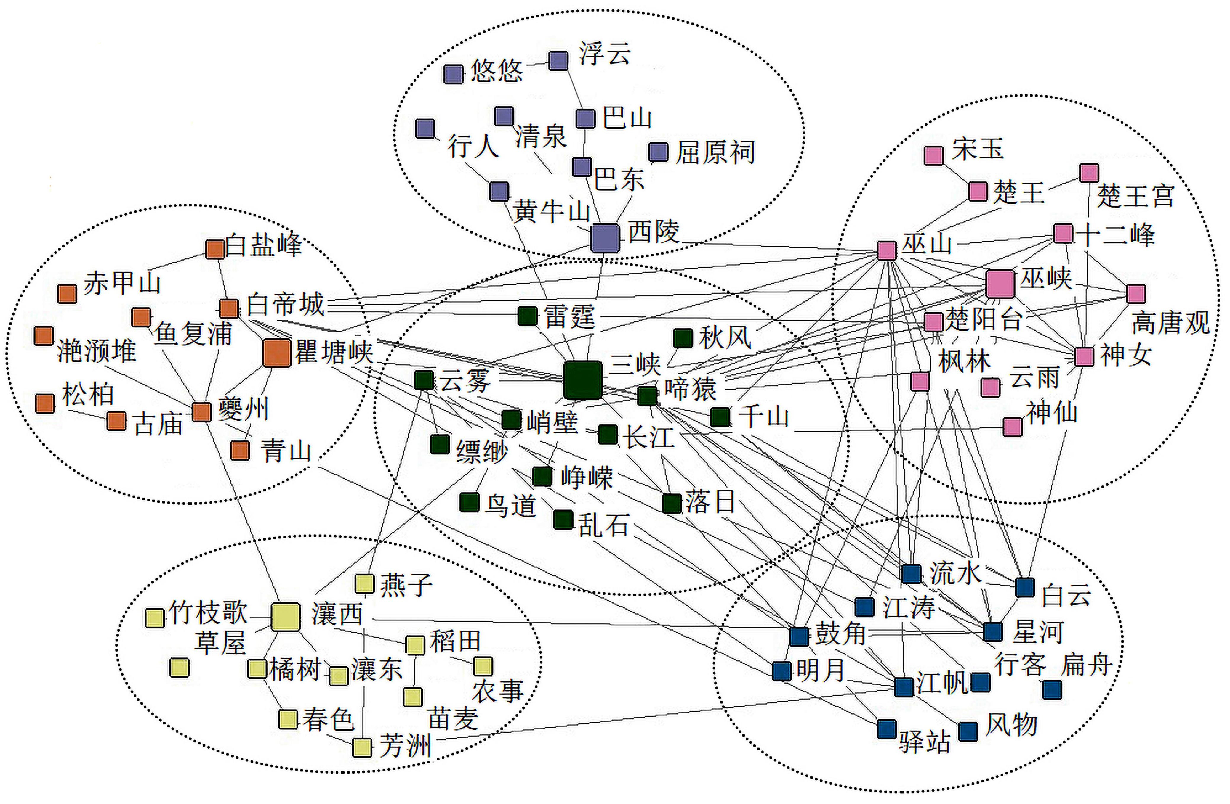
The Three Gorges is an important natural geographical landmark and one of the regions with the most abundant cultural heritage preservation in the Yangtze River Basin. Therefore, establishing a demonstration area for the Yangtze River National Cultural Park has become an important site selection objective. Research on the cultural landscape characteristics of the Three Gorges highlights its characteristics as a representative symbol of China and promotes the identification, protection, and valuation of its iconic cultural resources. Despite the current situation, where only a few tangible remnants of the Three Gorges heritage exist, the cultural context remains largely intact. Ancient poetry, with its classical Chinese cultural characteristics and unique geographical expression methods, enriches the natural scenery and humanistic imagery of the Three Gorges. This provides a valuable tool for interpreting and understanding the cultural resources of the Three Gorges and enhancing its value interpretation system. The Tang and Song dynasties saw a surge in the number, representativeness, and influence of poetry related to the Three Gorges. This article analyzes 440 Tang and Song poems about the Three Gorges, focusing on its geographic information and cultural landscapes. Using text mining technology, we extracted the most representative cultural landscapes in the area and visualized the types and distribution these cultural landscapes ArcGIS spatial analysis. Additionally, cluster analysis and spatial semantic analysis were conducted on poetry texts using ROST-CM6 to categorize different landscape themes. The cultural connotations and aesthetic characteristics of each theme were then analyzed by combining semantic networks with high-frequency words and characters. Our findings indicate that the Three Gorges cultural landscape during the Tang and Song dynasties was mainly composed of historical sites, temples, ancestral halls, and former residences of renowned figures. The landscape formed a string of beads along the river and primarily centered on Fengjie and Wushan. We identified six landscape themes on the semantic network, including the Xiajiang Grand View, the ancient capital of the White Emperor, the scenic spots of Xiling, and the clouds and rain of Wushan. The Three Gorges segment of the Yangtze River National Cultural Park followed the "One Belt, One Zone, Two Cores" spatial layout concept, with poetry culture as the soul, the poet's location as the pulse, and renowned mountains and scenic spots as the body. Historical scenes were reconstructed through logical and emotional methods, injecting the aesthetics, culture, and emotion of poetry and its historical background into the basic landscape.
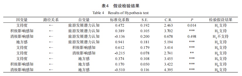
As the owners of tourism resources and influencers of tourism development in a destination, residents' attitudes play a significant role in the development of tourism in the exploration stage. During this first stage in the life cycle of a tourism site, residents support changes significantly owing to the influence of tourism development. However, many scholars have focused on the development, consolidation, and maturation stages of tourism development, with the exploration stage often being neglected due to its less obvious performance characteristics. Therefore, the applicability of current research findings to the exploratory stage is highly questionable. To address this issue, this study selected Beigang Village in Haikou City, which is currently in the exploratory stage, as a case site. Using the behavioral decision theory and a quantitative research method, we explored the influence of the following factors on residents' tourism support in the exploratory stage: tourism development potential perception, positive influence perception, negative influence perception, sense of place, and residents' support. The main conclusions are summarized as follows: (1) During the exploration stage of tourism development, tourism development potential perception, positive and negative impact perception, and sense of place significantly impact resident support. In addition, tourism development potential perception is a key core factor, which not only influences residents' support through direct and mediated effects but also has different effects on residents' tourism impact perception and sense of place. (2) Tourism development potential perception has a moderating effect on the relationship between sense of place and positive impact perception. For residents with a stronger sense of place, their tourism development potential perception has a significant positive effect on positive impact perception; for residents with a weaker sense of place, their tourism development potential perception does not influence their positive impact perception. (3) Both rational and irrational factors played a role in the residents' subjective decisions during the exploration stage. Overall, this study constructs a conceptual model of resident support in the exploration stage and analyzes the relationships between tourism development potential perception, positive and negative influence perception, sense of place, and resident support. Moreover, it plays a guiding role in the development of tourism destinations in the exploration stage and suggests that local governments and tourism developers should take active steps to improve residents' support for sustainable tourism development.
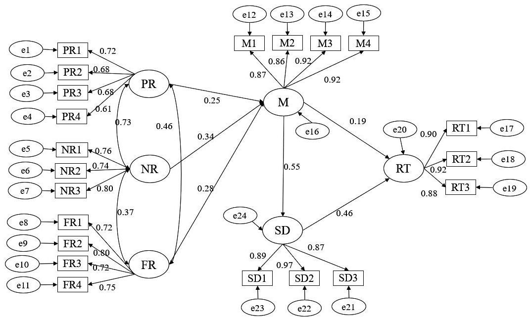
Globally, the surfing tourism industry has matured, as has the research in this sector. In recent years, surfing tourism in China has been favored by domestic risk preference tourists because it can meet the demand for adventure sports tourism, and a number of surfing tourism resorts have emerged. However, domestic-related theoretical research is obviously insufficient. Utilizing the theories of risk edge and emotion evaluation theory and taking Riyue Bay, Wanning City (Hainan Province) as the research area, tourists were surveyed in order to ascertain emotion and experience as factors to incorporate in a structural equation model. The intermediary effect analysis method was applied to explore the impact mechanism of risk perception on the intention of surfing tourists to revisit, in order to provide theoretical support and countermeasures for the sustainable development of domestic surfing tourism. The data collected in this study were verified as representational, reliable, and effective, and the model fitted the data well. Based on the results, the following two conclusions can be drawn. 1) On the one hand, risk perception has a significant direct and positive impact on emotional arousal of the surfer, and emotion plays a completely intermediary role in the impact of risk perception on intention to revisit; that is, risk perception has no significant direct impact on intention to revisit, which is in agreement with some studies and contradicts others. On the other hand, experience quality plays an intermediary role in the influence of emotion on revisit intention, and the intermediary effect is slightly higher than the direct effect. These conclusions indicate that surfing tourism operators should not only fully mobilize the positive emotions of surfers, but also find ways to let surfers obtain a higher-quality surfing tourism experience to better attract repeat visitors. In order to promote the sustainable development of surfing tourism in Riyue Bay, Wanning City, we make the following suggestions. First, risk preference tourists should be considered the main target audience in marketing. Second, management norms should be established for surfing clubs (stores) and evaluation mechanisms for surfing coaches. Third, safety supervision should be strengthened to enhance the surfing experience. Lastly, surfers should be helped to successfully surf and stimulate positive emotions. Although there are still some limitations, these preliminary results advance the field of risk perception in tourism, both in theory and in practice.
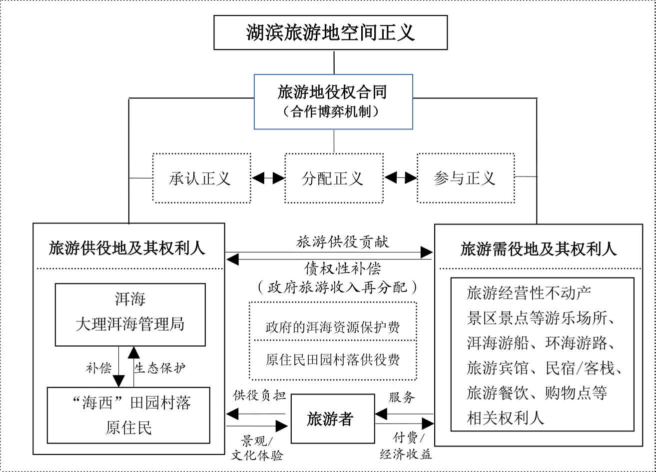
In recent years, the ecological control of lakeside areas and the issue of spatial justice and injustice have aroused widespread interest in the academic community. This field of research would benefit from greater scientific measurement of the degree of spatial justice. Using the results of relevant studies of several lakeside areas, we applied the principles of space production (sensu Lefebvre), Fraser's scale theory of social justice, and the factor analysis method of structuring quantitative models. With this approach we constructed a spatial justice measurement model of lakeside tourism sites from the perspective of the perception of indigenous people, a vulnerable group, and the right holders of tourist service land. Taking the west bank of Erhai Lake as the research object, the villagers were surveyed by using the five-point Likert scale, and the model was tested and measured. The key results were as follows. (1) The spatial justice perception model of lakeside tourism destination can be characterized by the dimensions of recognition justice, distribution justice, participation justice and 13 measurement indexes. (2) The perceived value of spatial justice of the "Haixi" villagers with respect to the tourism destination of the lake is quantified as 2.67, which is biased towards injustice in general, especially in the dimension of distributive justice (2.34). (3) The results of this study provide a preliminary measurement tool for the assessment of spatial justice of lakeside tourism destinations and can inform the decision-making of the relevant government departments to improve the local perception of spatial justice in areas where indigenous people live. Another outcome of this study is the proposal that the easement system is an effective way to realize the spatial justice of the "Haixi" tourist destination. However, it is worth noting that after the lakeside redevelopment, fewer tourism operators in the "Haixi" area can sustain themselves; thus, it will be difficult to add tourism business opportunities in an area that already has significant space constraints. The repercussions of the space limitations have spread to to the periphery of the first and second control areas and even to the entire Dali, Yunnan Province. In Dali, Yunnan Province, through fair market transactions between the rights holders of tourism real estate and tourists, the redistribution of tourism economic income can be realized. The crux of solving the spatial injustice of the lakeside tourism destination of Erhai Lake lies in the institutional "confirmation" of the rights and interests of Erhai Lake and its lakeside area (the largest area of tourism service) and through the imposition of different degrees of "paid use of Erhai resources" on all tourism operators, as well as government payments to increase the compensation given to the indigenous people in the lakeside area. In other words, only by establishing a community of co-construction, sharing, and co-governance of rights holders and tourists in the Erhai Lake-and in tourism destinations generally-can the spatial justice be truly realized.