A short overview of the history of academic geography since the 19th century shows that there has never been a unity of physical and human geography in the past, at least in the form that is strived for today to justify the relevance of geography in coping with the present problems faced by humanity. But the fact that the limits of positivism start to be recognized in physical geography opens a way to collaboration for addressing the pressing problems affecting our planet today. The paper ends with some examples of how such a collaboration might look like and advocates greater attention to a political chorological approach, concentrating on the diversity of regions in the world, by taking both their internal and external relationships in terms of power structures into account.
The differentiation of physical geography and human geography is consistent with the differentiation of science, which is always in progress. Both have their advantages, and both have made contributions to scientific cognition and practical application. However, they also share common interests and means, which can give full play to their advantages and provide unique academic support for understanding and solving numerous social and environmental problems and challenges faced by contemporary human beings.
Inspired by the article co-authored by Christian Kesteloot and Lorenzo Bagnoli, this paper proposes three bases for the integration of physical geography and human geography. First, the ontologies faced by the two academic groups need to be close; second, the two academic groups must embrace each other's methodology; and third, the organization of scientific research operation should be conducive to integration. In order to better demonstrate these three integration bases, this paper considers the case of color control in the central city of Beijing, and analyzes the difference research approaches of physical geographers and human geographers when they face this practical issue in the absence of these three bases, as well as trends in their divergence.
The environment is a common research subject of physical and human geography, serving as a bridge toward the integration of these two sub-disciplines within geography. In order to study the interaction between human and physical geographical processes and the complex earth landscape it generates, incorporating the concept of region and corresponding research methods can be a possible direction to simplify the complexity of the problem. I argue that the division and analysis of regions should be based on geographical processes, emphasizing the discovery of chain reactions within these processes. Although there is a degree of subjectivity in the division of region among geographers, a good regional delineation should uncover more important and objective facts, reveal deeper truths, and therefore gain higher recognition. The unity of physical and human geography is evident in the cognitions and actions that human societies take regarding the interactions between physical and human geographical processes, which the comprehensive study of geography should able to explore, analyze, organize, and interpret.
The 21st century has seen an exponential growth in the number of papers published by Chinese geographers, yet this surge in publication has not corresponded to a commensurate increase in societal impact. The voices of geographers, particularly those of the younger generation, have diminished when confronted with substantial scientific and societal challenges. A pivotal factor contributing to this phenomenon is the academic evaluation system, which places significant emphasis on the quantities of papers and projects. This system significantly impedes cohesive progress in the field of Chinese geography, leading geographers, especially the younger generation, to diverge from the fundamental principles of the discipline. Consequently, there is a gradual neglect of the "comprehensiveness" and "regionality" dimensions that geography traditionally employs to tackle significant issues. To augment the capacity of geography to confront crucial challenges and enhance its standing within both the disciplinary and societal realms, Chinese geography should embark on a trajectory of consolidated development. This includes crucial steps such as strengthening geography education, establishing a leading problem-oriented framework, outlining pathways for integrating physical and human geography, and utilizing initiatives such as the "Top Ten Research Progresses in Chinese Geographical Science" to guide synthesized geographic development.
Major natural and social problems have emerged since the onset of the Anthropocene because of which geography, as a typical interdisciplinary field, has faced unprecedented challenges and opportunities. Given its focus on the complex human-nature relationship, it is necessary to overcome the dualism bias between physical and human geography and prioritize the study of coupling human-nature relationship within the discipline. In the context of Chinese geography, the key and the biggest difficulty of such coupling lies in the methodology used. To solve these major problems, the geographical community should encourage participation in diversified interdisciplinary research and promote the integration of data, technology, and society to bring about a new paradigm of governance science. This shift entails a gradual departure from the prevailing disciplinary evaluation orientation that tends to prioritize physical sciences over social sciences and humanities. Coupling physical and human geography and collaboration between geography and other disciplines are necessary to overcome the common global sustainable development issues.
Geography, as a discipline, is keeping pace with the overall development of scientific systems. The 20th century division between physical and human geography dispelled the integrity and unity of geography, while the division of specialties and the deep development of research topics further eroded the discipline. In anticipation of the synthesis of complexity and earth system science, and new sciences in the 21st century, and against the background of globalization and sustainable development, nature and humanities should be reintegrated in university classrooms. The influence of dualism can disappear invisibly through the standardization of academic language, construction of discipline theories, and transformation of research paradigms. Furthermore, an integrated and systematic concept can execute the arduous and complex task of safeguarding the future of humanity and sustainable development of the earth.
The two branches of physical and human geography have become increasingly prominent in geography. This division is evident in the choice of topics, the selection of publication journals, and the subjects of academic dialogue. Therefore, this relationship between the two branches of geography requires discussion. Maintaining the integration and utility of geography can help highlight its advantages and deal with the comprehensive and global problems faced by humankind. Human-land relations and regional geography emerge as specific approaches to mitigate geographical division, with the geographic information system as a tool to bridge the two branches. The public's demand for geography is met through regional geography and regional geographic books are essential to meet the needs of the public. Focusing on public communication in regional geography writing can contribute to improving the social recognition of the discipline.
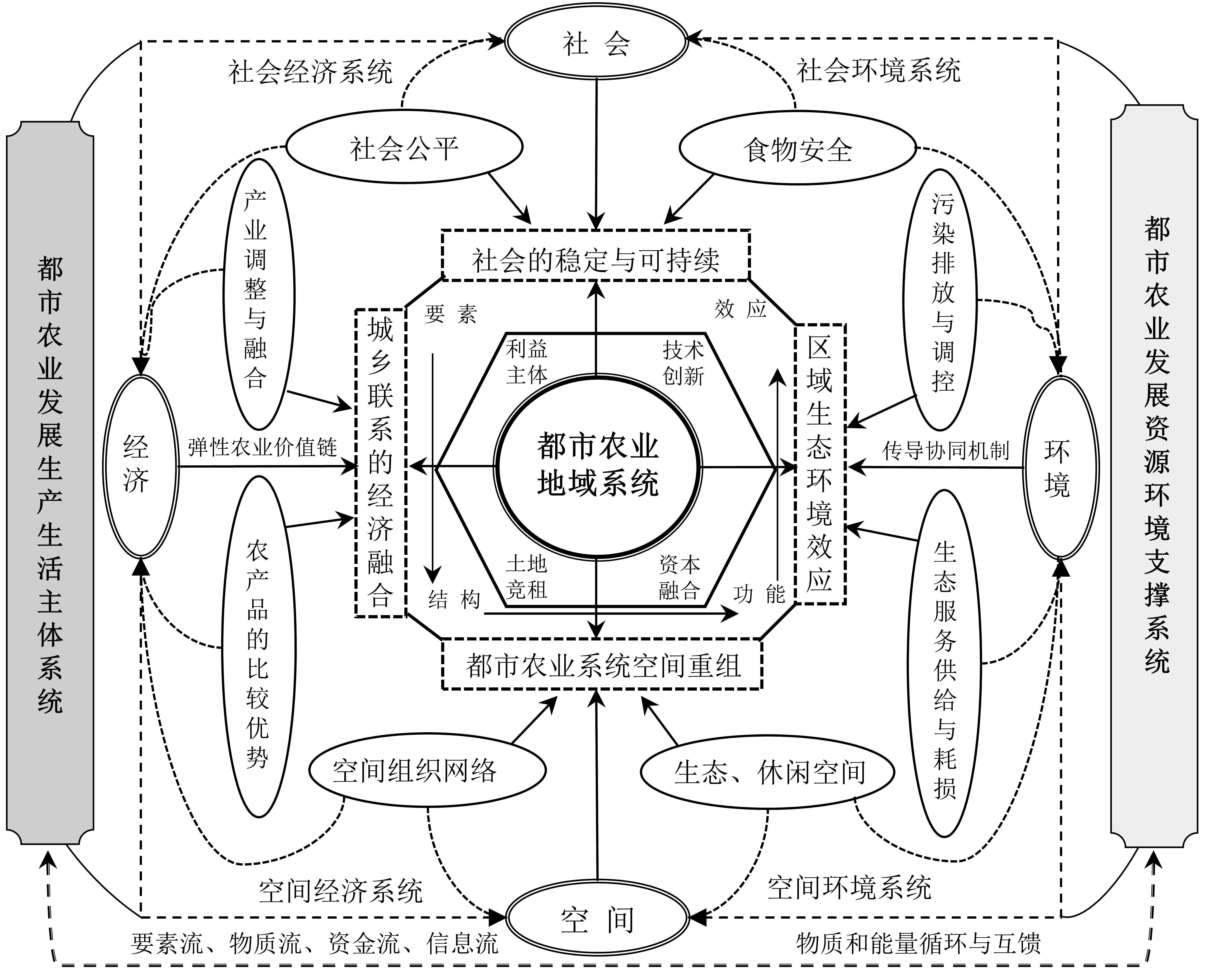
Under the auspices of the national strategies for urban-rural integration and rural revitalization, a focus on the functional evolution and spatial reorganization mechanisms of urban agriculture is of great theoretical and practical significance. This paper analyzes research progress in urban agriculture functional transformation and presents key scientific issues in urgent need of attention in future research. This paper aims to promote high-quality, ecologically sound development of urban agriculture and provides a scientific basis for integrated development of urban and rural areas. We have found that: 1) Research into urban agriculture functional transformation mainly focuses on evaluation and division of urban agriculture development transformation into type models, including multi-functional transformation and sustainable development of urban agriculture, spatial organization and production organization pathways of urban agriculture, land use and bidding mechanisms applied to urban agriculture development, and problems arising from urban agriculture and its multi-dimensional effects. At present, research related to the functional transformation of urban agriculture is guided by the theories of agricultural development, agricultural multi-functionality, and agricultural product demand, focusing on land alienation, ownership security, and diversification of agricultural production subjects in the process of urbanization. 2) The development of urban agriculture presents complex characteristics (i.e., it is multi-subject, multi-linkage, and multi-objective), and coordination of mixed social relations based on the demands of different stakeholders can also pose difficulties. The process and results of the cooperative game of urban agricultural space rental competition and subject interests exert crucial impacts on the restructuring of urban agricultural production system and spatial organization. The dynamic mechanisms of functional evolution and spatial reorganization of regional urban agriculture systems need to be studied. An urgent need exists to strengthen research into land bidding, land tenure, and related stakeholders in urban agriculture development from the perspective of regional systems. It is necessary to clarify the basic and dominant factors influencing the evolution of urban agriculture systems based on different scales, subjects, and perspectives and to elucidate the rent competition mechanism underlying spatial reorganization and ecological and environmental effects. 3) Future research needs to solve key scientific issues regarding three aspects of urban agriculture functional transformation. First, from the perspective of the rural-urban continuum, to clarify the interaction linkage and coupling mechanism between endogenous and external forces driving regional functional evolution in urban agricultural systems. Second, to reveal the key mechanism of spatial restructuring of regional urban agricultural systems and clarify synergies among stakeholders and the logic of land bidding. Third, based on the ecological and environmental impacts of the functional evolution of regional urban agriculture systems and spatial reorganization, comparative studies on the ecological impact of regional functional transformation of agricultural systems at different locations on urban-rural spatial gradient transects are needed.
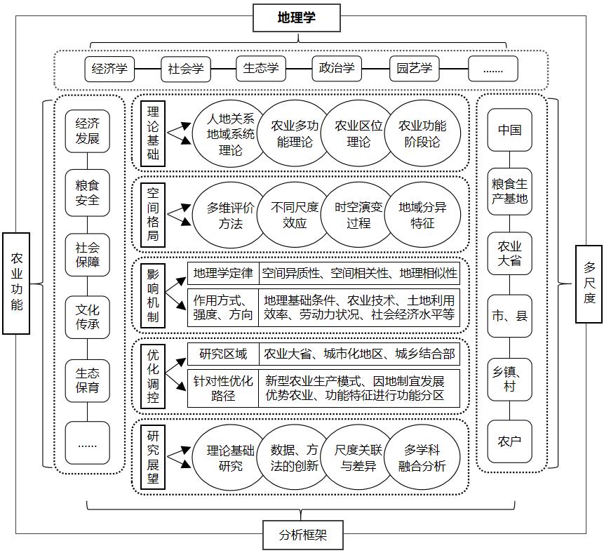
With the rapid advancement of China's urbanization, industrialization, and marketization, and the in-depth implementation of the rural revitalization strategy, the response of the territorial system of human-environment interaction in rural areas is intense, and the agricultural industry has shown a diversified development trend. Sorting and summarizing the existing research on domestic agricultural functions is important for promoting sustainable agricultural development in the new era, accelerating agricultural transformation and upgrading, and comprehensively revitalizing rural areas. Domestic scholars attach great importance to agricultural development and the services that the agricultural industry provides to society. Geographers have used their disciplinary advantages and have gradually integrated multidisciplinary theories and methods to conduct numerous studies on the conceptual connotations, theoretical bases, classification systems, measurements and evaluations, spatiotemporal processes, influencing factors, and optimization paths of agricultural functions. The academic circle has initially formed the geographical research paradigm of "theoretical basis-spatial pattern- evolution process-influence mechanism-optimal regulation." This study reviews the research progress of agricultural function in China from the perspective of geography and draws the following conclusions: 1) Based on the sorting of the definition of agricultural function in China, this paper defines agricultural function as the role or utility of agriculture, that is, the services and responsibilities that the whole agricultural industry chain renders to the whole society at different times and spaces, including providing products, solving employment problems, inheriting culture, maintaining social stability, and providing ecological services. Furthermore, it has comprehensive, cross-sectional, and regional characteristics. 2) The theoretical basis of agricultural function research includes the territorial system of human-environment interaction, agricultural multifunction, agricultural location, and agricultural function stage theories. Geographers can further improve and enrich relevant theories of agricultural functions through continuous research. 3) Considering the contribution and support of agricultural development to regional socioeconomic development and residents' lives, the researchers divided agricultural functions into product supply, economic development, social security, ecological maintenance, cultural leisure, and so on, and the spatial changes and regional characteristics of agricultural functions were further studied using GIS and RS technology and a geographic mathematical model. 4) The development of agricultural functions is affected by regional natural conditions, economic level, science, and technology. Scholars systematically integrate natural, social, economic, and other factors; scientifically diagnose each factor's mode, direction, and intensity of action in different geographical environments; and perform functional zoning and optimization based on the regional geographical environment and main influencing factors, thus promoting the transformation and development of agricultural functions toward specialization and diversification. 5) Based on summarizing the achievements of agricultural function research conducted by domestic scholars, the shortcomings of existing research in fundamental theory, method and data innovation, scale correlation, and multidisciplinary integration are discussed, and the need to improve the theoretical framework system of research in the future to promote multi-factor, multi-scale, and multi-objective systematic research is proposed. In addition, it is necessary to focus on the transforming of agricultural functions, and strengthening the integration of multidisciplinary, big data and new technological means.
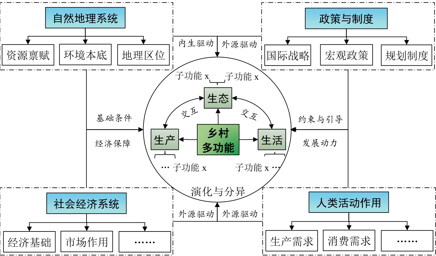
As a forward position to realize urban-rural integration development, the rural multi-functionality of metropolitan suburbs, which faces higher requirements in terms of governance, taking over the core functions of the metropolis and meeting its consumption needs, has recently gained much attention among scholars and policymakers. However, there is a shortage of comprehensive summaries of the rural multi-functional development rules(about patterns, differentiation characteristics, etc.) in metropolitan suburbs, as well as relatively little research specifically on the multi-functional development of such areas. This has led to the emergence of a range of issues such as unclear connotations, lack of guidance, and disability of revitalization. In the future, establishing how to meet the diversified needs of cities and residents through function expansion, and how to revitalize such rural areas through the optimal combination and coordinated development of functions will be key issues that need to be solved in the practice of urban-rural integration development. Consequently, based on scientific identification regarding different needs of the urban-rural subject in the metropolis, this paper first defines the connotation of the rural multi-functionality of metropolitan suburbs—the sum of all kinds of services and functions that can be provided to meet the various needs of urban and rural residents, maintain the suburban villages themselves, and rely on the integration and symbiosis of the metropolis and the coordinated development of urban and rural areas—and then presents a multi-functional classification system from the perspective of "production-living-ecology" functions. Second, this thesis summarizes the mechanisms and trends that motivate the evolution of multi-functionality in the suburban villages of the metropolis: 1) Overall, the multi-functional development of rural areas is generally considered to be the result of the joint action of natural geographical systems, socio-economic systems, policies and systems, and human activities, similar to that of the evolution of traditional village functions. However, the contribution of such factors that influence the choice of direction of functional expansion, the speed of functional evolution, and changes in functional intensity in the suburban villages of the metropolis varies enormously. 2) Compared with general rural areas, the rural multifunction of metropolitan suburbs is the first to present the evolution trend of "modernization and characterization of production functions, convenience and humanization of living functions, and greenization and sustainability of ecological functions." Finally, the innovative directions of the future collaborative evolution of rural multi-function in the suburbs of the metropolis are drawn from four aspects: 1) construction of a basic theory and classification system, 2) identification method of rural multi-functional zoning under the constraints of innovative development planning policies, 3) active exploration of typical paths and modes of multi-function collaboration, and 4) improvement of the policy support system for the transformation and development of rural multi-function. This study will be of great significance in optimizing urban-rural relations in the metropolis, promoting urban-rural integration, and guiding the optimization and development of local rural functions and rural revitalization.
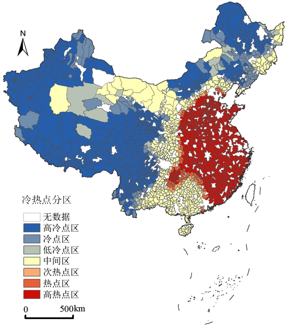
The 14th Five-Year Plan states the following: "Accelerate the construction of digital countryside, build a comprehensive information service system for agriculture and rural areas, establish an inclusive service mechanism for agriculture-related information, and promote the digitalization of rural management services." As an important combination of "Digital China" and "rural revitalization" strategies, the so-called digital countryside not only helps promote the development of digital agriculture but also is an important aspect of rural digital governance, which is significant in the modernization of agriculture and rural areas. The spatial collaborative development of a county digital countryside needs to re-examine the spatial and temporal patterns related to the development of a county digital countryside. Accordingly, this study adopts an exploratory spatial data analysis method to study the spatial autocorrelation characteristics related to the development of a county digital countryside. The three-stage nested Theil index method is used to measure the spatial difference characteristics regarding the development of a county digital countryside. The driving factors behind the development of the digital countryside are determined via the geographic detector analysis method. Subsequently, this study presents that the development level of China's county-level digital villages shows obvious "gradient" characteristics, and the development level of digital villages gradually decreases from east to west. Moreover, the digital villages show "flake distribution" in the Yangtze River Delta region, and "dot distribution" in the western and northeast regions. China's county-level digital villages exhibit the spatial characteristics of "large agglomeration and small dispersion." The regions with high development level of digital villages are mainly distributed in the Yangtze River Delta urban agglomeration and spread around Jiangsu and Zhejiang provinces as the center. The spatial autocorrelation index between county digital countryside, rural financial infrastructure, rural digital infrastructure, rural economy digitization, rural governance digitization, and rural life digitization is significantly positive, indicating that the development of digital countryside has significant spatial autocorrelation characteristics and is affected by geographical proximity. For example, a county unit with high digital rural development level is commonly adjacent to another county unit with the same high digital rural development level. The development of China's county-level digital villages exhibits obvious spatial agglomeration characteristics, forming "high-high" agglomeration in the Yangtze River Delta region with higher economic development level and relatively perfect network infrastructure. Digital rural development presents a "center-periphery" structure with sub-hot spots and hot spots clustered around high hot spots. A T-shaped strip is formed between the hot and cold spot areas to separate them. The overall Gini coefficient of rural digital development at the county level in China is 0.035 9, and the regional gap in rural digital development is the main source of this gap. The industrial economy, population, education, finance, and infrastructure strongly influence the spatial distribution of the digital countryside. The contribution of this study is mainly reflected in revealing the spatial pattern, spatial difference, spatial agglomeration, and driving factors behind the development of the digital countryside from the perspective of a county level, which enriches the relevant research on the spatial analysis of the digital countryside and provides empirical evidence for promoting the collaborative development of the digital countryside.
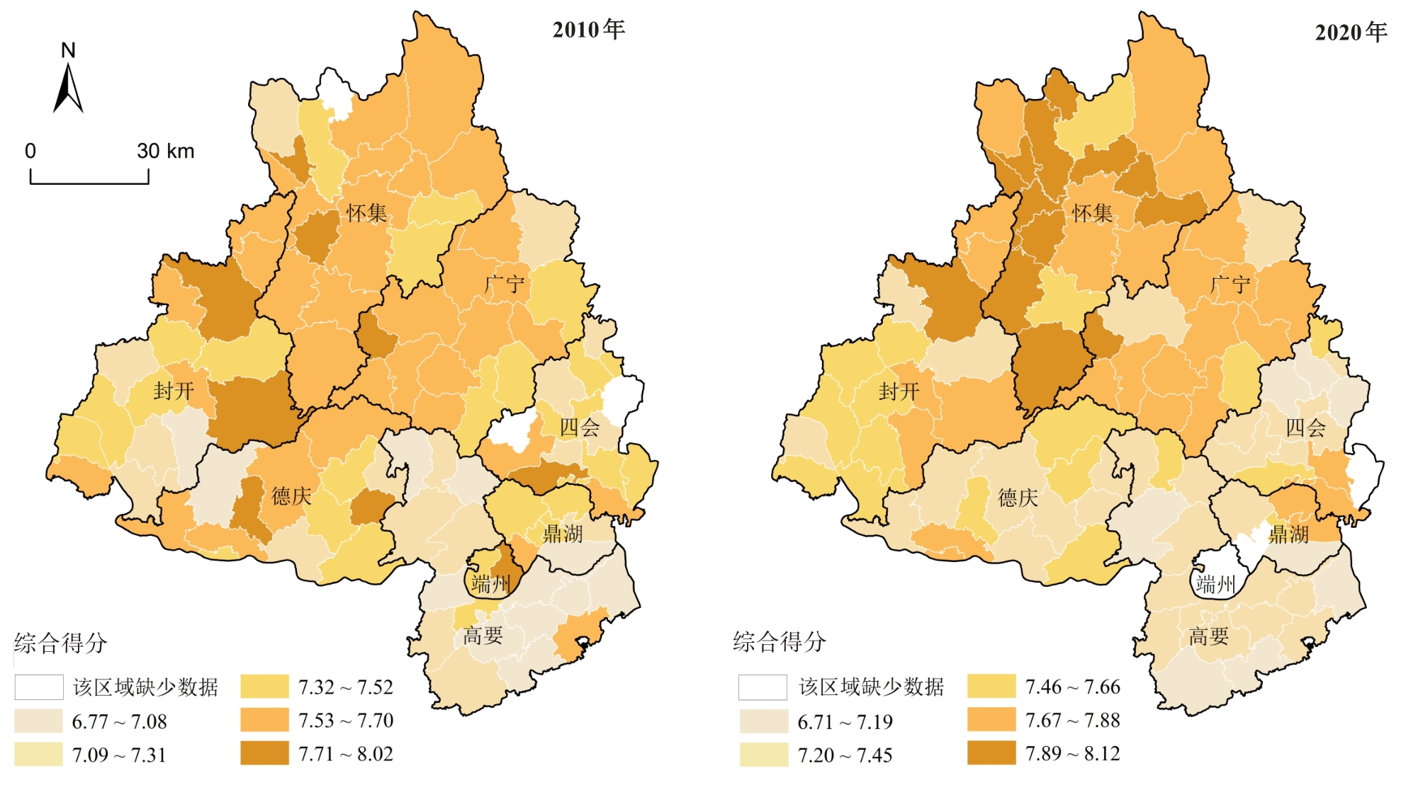
Academic circles have long ignored the problems of inadequate and unbalanced housing development in medium-sized cities. Based on data from the sixth and seventh national population censuses of Zhaoqing City, this study constructed the resident housing evaluation system focusing on four sub-systems: construction age, building structure, per capita floor area, and housing living facilities. Through global and local spatial autocorrelation analyses, the spatial-temporal differentiation pattern of residents' housing conditions in Zhaoqing City from 2010 to 2020 was described. An OLS regression model was used to identify the influencing factors of the comprehensive score of residents' housing conditions, revealing the driving mechanisms of the evolution of the spatial pattern of housing conditions. The results show that 1) From 2010 to 2020, the spatial difference characteristics of the housing conditions of residents in Zhaoqing City showed obvious changes, with the high score area shifting from southeast to northwest. 2) The housing conditions of residents showed significant spatial agglomeration characteristics. The spatial agglomeration degree of the overall housing condition score did not change much in the past 10 years, while the spatial agglomeration degree of the construction age, building structure, and housing living facilities scores decreased significantly. 3) In 2020, the housing conditions of urban residents and rural residents presented different spatial differentiation patterns. The per capita floor area subsystem of rural housing dominates the spatial differentiation pattern of housing conditions for all residents in the city. 4) Regarding driving mechanisms, early urban forms constitute the historical basis of the spatial pattern of housing conditions in Zhaoqing City. Government policies and planning are the key driving forces shaping the evolution of spatial patterns, and the filtering effect of the housing market further strengthens the established spatial pattern. Based on these findings, the study proposes the following policy implications for Zhaoqing City: 1) Accelerate the upgrading of the industrial structure and new type urbanization construction, and encourage the city's agricultural migrant population and migrant workers to find jobs and settle down in the central city, development zone, and county; 2) Increase the supply of affordable housing with better housing quality in Zhaoqing New District and High-tech Zone to attract and retain highly skilled talents and college graduates; 3) Control the supply scale of residential land in the New District and High-tech Zone, increase the supply scale of industrial land, and expedite the introduction of strategic industries; 4) Conduct micro-transformations of old residential areas in the old urban areas, upgrade infrastructure and indoor living facilities, and improve the quality of the living environment. This study discusses the evolution trend and driving mechanisms of the spatial differentiation of housing conditions in small- and medium-sized cities and offers policy implications to comprehensively improve the housing conditions of Zhaoqing residents based on local conditions. This has significant reference value for promoting the optimization of housing conditions in small- and medium-sized cities and improving the overall living conditions of citizens.
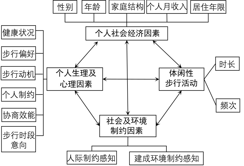
Studies on leisure walking among older adults have received extensive attention from various areas such as public health, medicine/prevention, sports, geography, architecture, urban/transportation planning, and leisure, as they focus on various themes, including the health benefits of walking, walking behavior surveys, walking behavior, and influencing factors. In such an information-dense study, the duration and frequency of walking are proven to be critical indicators used to evaluate physical activity and are widely applied to provide an essential basis for health interventions for older adults. Leisure walking is the most common activity among older adults in China and is generally performed daily. However, studies on leisure walking among older adults in China remain lacking, leading to the urgent need for additional empirical studies. This study attempted to build a framework for the factors influencing the duration-frequency pattern of daily leisure walking among older adults using the ecological model theory, which could be used as instructions for the case studies. This study was performed using 1,285 samples of leisure walking behavior of older adults in Nanjing. Multivariate logistic regression and other methods were used to explore the duration and frequency pattern of daily leisure walking and its influencing factors among older adults in Nanjing. The results showed that: 1) even though most older adults in Nanjing have not reached the physical activity level recommended by the World Health Organization. In general, the duration and frequency of daily leisure walking among older adults in Nanjing is characterized by "medium duration and high frequency", with the medium and high duration accounting for 75.02% and the medium and high frequency accounting for 89.96%, and the duration and frequency pattern of leisure walking differed among groups. 2) Certain factors commonly influence the duration and frequency pattern of daily leisure walking among older adults in Nanjing, including individual social factors, such as gender, family structure, and residence time in Nanjing, and psychological factors, such as walking preference, walking motivation, perception of personal constraints, and walking behavior intention. 3) The study reports differential factors, including health conditions, negotiation efficacy, and perceived constraints of the built environment, that could affect the duration pattern of daily leisure walking for older adults. The study reports that age and monthly personal income were the main factors influencing the variable frequency pattern of daily leisure walking among older adults. Based on the above study, theoretical and practical implications for facilitating leisure walking participation among older adults in China are discussed.
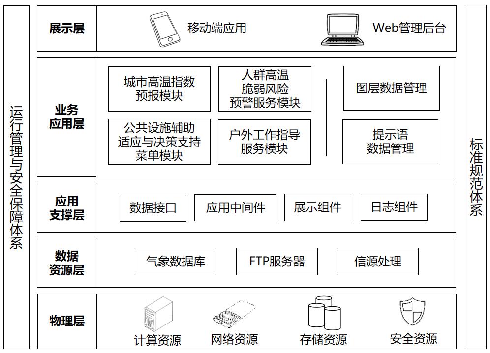
Extreme heat events caused by climate change have seriously threatened the sustainable human-environment system development. It has become the frontier of integrated geography to scientifically assess the comprehensive impact of heat waves on the urban system and to provide stakeholders with decision support services to cope with extreme heat. This study constructed an "exposure-susceptibility-adaptive capacity" framework for urban heat vulnerability and an early warning index system based on the perspective of the human-environment system. We then proposed key early warning technologies, including an urban heat index model, multi-subject adaptive capacity coupling technology, and a multi-group vulnerability assessment criteria library. Taking urban diversified groups and urban administrators as the service target, we designed the urban heat vulnerability early warning system. The system mainly comprises a mobile application that provides users with an interactive interface, and a dedicated management backend. The mobile application has four main functions: Urban heat index forecast, Crowd heat vulnerability risk warning service, Outdoor work guidance service, and Public facility-assisted adaptation and decision support menu. The layer data and the warning message are mainly handled by the dedicated management backend. The system provides hourly location-based heat vulnerability warnings and targeted healthy living tips for tourists, the elderly, children, and people with heat-sensitive conditions. Additionally, the system can provide a scientific basis for communities to improve their adaptive capacity to heat waves. As a pilot, the system was deployed in Xiamen City to provide personalized support services for healthy living in hot weather to residents and communities. In September 2021, the "Urban Heat Index" module was officially launched on the "Zhi Tian Qi" public meteorological service platform of the Fujian Province. The research perspective and methodology, based on a multiscale vulnerability framework, provide an effective method to dynamically and finely characterize the impacts of extreme natural hazards. The research results support urban multi-stakeholders in managing production and life during hot weather and help authorities develop targeted disaster prevention and mitigation plans for specific areas. Moreover, the findings provide a scientific reference for planning departments to improve and optimize the spatial allocation of emergency resources.
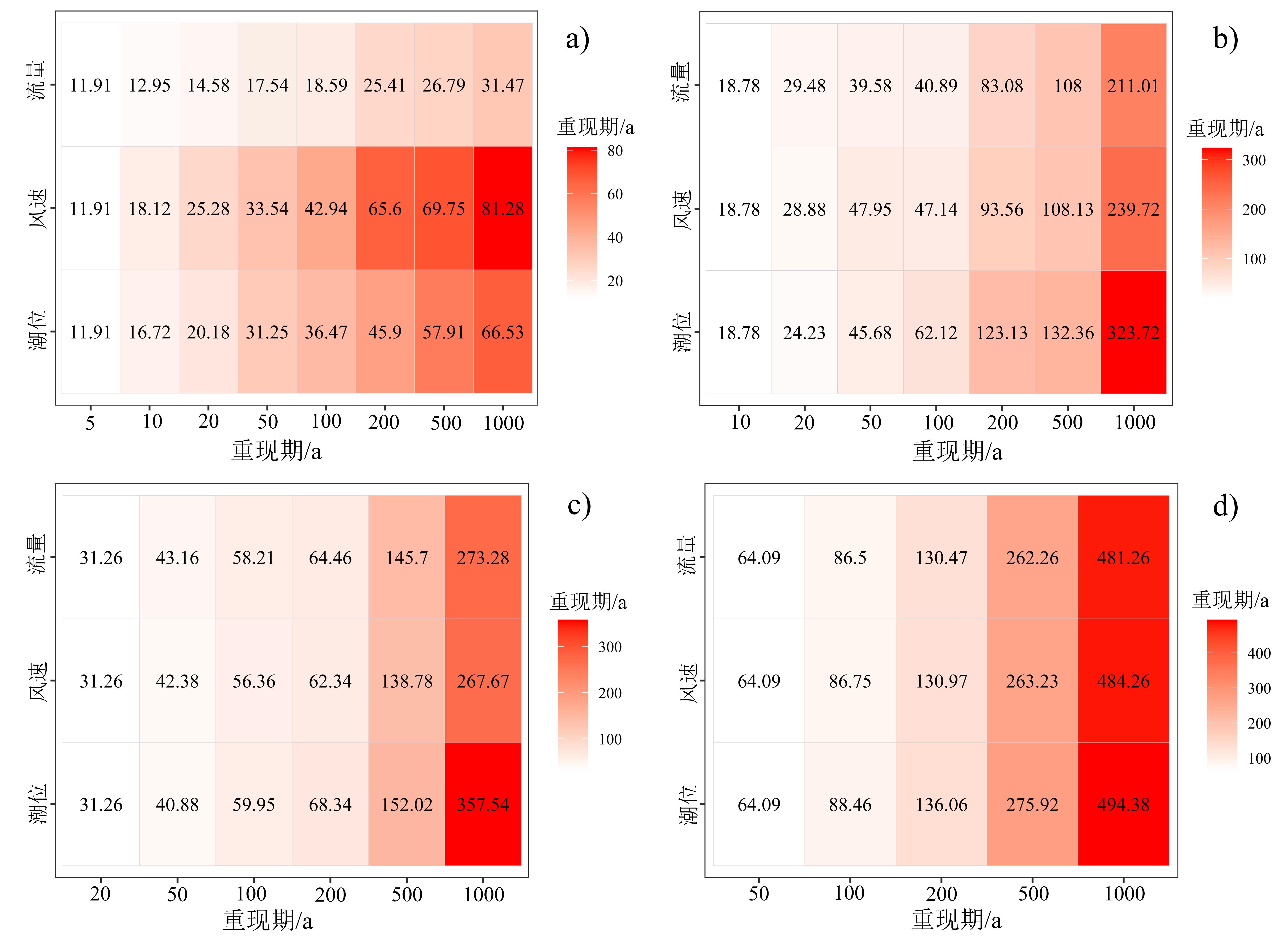
In conjunction with global warming, the frequency and intensity of typhoons in the Pearl River Estuary region are increasing annually, and coastal cities are becoming more vulnerable to compound disasters triggered by upstream flooding, typhoons, and astronomical tide surges, seriously threatening the lives and properties of people in the delta region. Quantitative analysis of the degree of variability of each factor associated with a compound flood event and accurate assessment of the magnitude of the compound flood event strongly impact the efficacy of coastal city responses aimed at disaster prevention and damage mitigation. In this study, focused on the Pearl River Estuary area, the tide levels at Sanzao station, wind speeds at Macao station, and daily maximum the maximum daily flow at Sanshui and Makou stations spanning 30 years from 1988 to 2017 were used to characterize the flood magnitude, typhoon magnitude, and astronomical tide magnitude of compound flood events in the Pearl River Estuary area. Data were screened using the annual maximum method. Based on the generalized additive model (GAMLSS) and the time-varying copula function, the encounter combinations of composite flood events of different levels and their main controlling factors were investigated. The results show that: 1) the main factors influencing initiation and magnitude of composite flood events in the Pearl River estuary area are non-consistent sequences that display interdependence. The time-varying copula model constructed in this study is more suitable for studies of composite floods than the traditional constant parameter copula model. Copula models are most applicable to studies of the encountered characteristics of multiple elements contributing to compound flood events and are most in line with actual situations. 2) Compared with the joint return period of traditional constant copula parameters, the period of occurrence of typical compound flood events in the Pearl River Estuary from 1988 to 2017 continuously shortens with time, the probability of occurrence increases, and the probability of future occurrence of extreme compound flood events is strengthening. The trend in which the return period of compound flood events is shortening with higher grades is accelerating. 3) Compound flood events throughout the Pearl River estuary area are more affected by typhoons and astronomical tides and less affected by water flow. When the return period of the three factors is one in 5 years, water flow causes the smallest increase in the co-occurrence return period; i.e., the influence of astronomical tide and typhoon on the scale of upstream flooding, composite flood events of typhoon, and astronomical tide is proportionately larger. Thus, composite flood events in the Pearl River estuary area are mainly impacted by typhoons with higher wind speeds. When the return period of the three factors is one in 10, 20, and 50 years, the increase in the co-occurrence return period caused by flow changes the most; and when the return period of the three factors is one in 10, 20, and 50 years, the acceleration of the co-occurrence return period caused by flow is the largest. When the three factors have a larger return period, astronomical tide exerts proportionately greater influence on the scale of the composite flood event of upstream flood, typhoon, and astronomical tide.
As urban development progresses, the complex phenomenon of city shrinkage increases. Perforated shrinkage is a leading pattern within Chinese cities. In this study, the Qingshan District in Wuhan (including its chemical industrial area) is considered as a representative case of a large metropolitan area experiencing perforated shrinkage. Through the use of methods such as spatial syntax, Point Of Interest (POI) analysis, and word frequency analysis, the study examines material and social spatial connections to verify the existence of an "island effect". The following results were obtained: 1) Analysis of the topological relationships within the Wuhan metropolitan development area and the interior regions of the Qingshan District reveals that Qingshan has low global and local integration values as well as choice metrics, indicating issues related to roadway accessibility and uneven distribution of transportation facilities. This leads to weak internal and external material spatial connections. Additional kernel density analysis of public facility POIs indicates poor and uneven infrastructure distribution in Qingshan. Additionally, questionnaire surveys and word frequency analysis suggest deficiencies in the area's external attractiveness and independent development at the policy level. These factors interact and contribute collectively to the island effect within Qingshan District. 2) Recognizing the similarities in the developmental background and policy frameworks between other domestic cities experiencing perforated shrinkage and the Qingshan District, this study infers that the island effect is a characteristic of metropolitan areas showing perforated shrinkage and is closely tied to institutional factors within Chinese urban areas. 3) The phenomenon of metropolitan perforated shrinkage and spatial connections have an interactive relationship, leading to the emergence of regional island effects. These island effects underscore the importance of coordinated internal development within the region, providing novel perspectives for managing urban shrinkage. For instance, cities should accelerate the development of transportation networks and construction of public spaces to avert feelings of isolation and closure at the spatial connection level, addressing the problem of unbalanced development with prompt promotion of policies emphasizing cooperation and talent attraction. This study's exploration and findings on the mechanisms and impacts of the isolation caused by perforated shrinkage highlight the urgency for better-coordinated development plans. This study presents innovative ways to address urban shrinkage aimed at improved urban infrastructural connectivity, equitable development, and resilient urban planning.
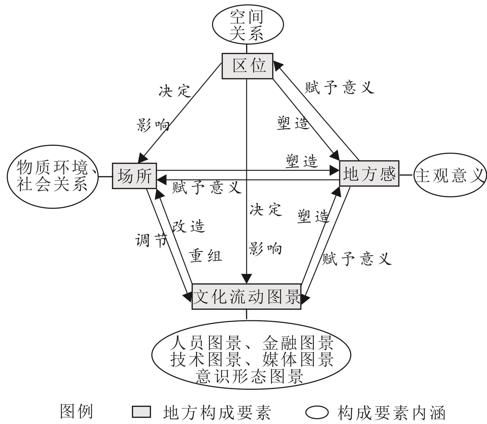
Place is a central concept and research object in cultural geography. Analyzing place components is a prerequisite for an integrated understanding of place and a core component of place theory in cultural geography. Previous studies have focused on either spatially fixed or mobile components in analytical frameworks, both of which capture different dimensions of place. However, few studies have considered both the fixed and mobile components and the interactions between them. Based on the classical framework of place components proposed by John Agnew (1987) and coupled with cultural flowscapes, this study proposes a new Analytical Framework for Place Components (AFPC) that reveals the elements of place. Taking the tourist destination of Fenghuang Ancient Town (FAT) as a case study and collecting data through observation and interviews, this study presents a preliminary empirical application of the AFPC. The results suggest that place comprises four components: location, locale, sense of place, and cultural flowscapes. Cultural flowscapes include the interrelated concepts of ethnoscapes, mediascapes, technoscapes, financescapes, and ideoscapes. The AFPC meets the scientific requirements of universality, independence, and application. It reveals the complexity of contemporary places and can be used to guide the empirical analysis of small-scale local characteristics or local specificality. The FAT case study fully reveals the multi-element features and interrelationships between the components. It was found that the location of the FAT is relatively poor, and the land-use pattern is mainly commercial. Social relationships in FAT are mainly commercial, social contact among residents is weak, and the sense of place for the different groups differed, Cultural flowscapes are dynamic and can play an active role in driving change or transformation of the locale of FAT. The locale has a mediating effect on cultural flowscapes. The location of FAT determines cultural flowscapes to some extent and partly affects the locale. Cultural flowscapes, location and locale together shape the sense of place of FAT, and the sense of place in turn gives specific meaning to the other three elements. The theoretical contributions of this study are that the AFPC considers both fixed and mobile elements of place components, and that place components are interactive, which helps enrich the theoretical perspective of place component research and expands the scope of application of place components theory. In practice, the research results can provide practical guidance for decision-makers in tourism destination development and rural revitalization, emphasizing that sustainable local development requires synergy between local and external elements.
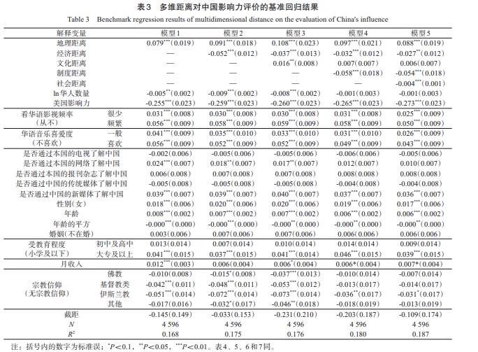
National influence pertains to the encompassing evaluation and general impression of a given nation. As the Belt and Road Initiative celebrates its 10th anniversary, it is necessary to deepen the understanding its achievements by analyzing China's national influence. Using data from the Overseas Chinese Enterprises and Employees Comprehensive Survey in Southeast Asia, this study employed the entropy method to calculate China's level of influence. Additionally, it analyzed the significant role played by multidimensional distance factors. The findings revealed that China's influence surpasses that of the United States among most Southeast Asian countries. The citizens of Singapore and Malaysia rate China's influence the highest, while those in the Philippines and Myanmar rate it the lowest. The impact disparity between China and the United States is the greatest in Malaysia, and is smallest in the Philippines. The regression analysis indicates that China's influence is impeded by economic, institutional, and social distance. Specifically, there is a negative correlation between the degree of economic gap and institutional differences with the evaluation of China's influence. Moreover, the lower the degree of acceptance of the Chinese people in Southeast Asia, the less likely they are to view China's influence positively. These findings imply similar patterns in the Southeast Asian evaluation of China's influence that is closely related to economic and institutional differences. Geographic distance and cultural proximity may enhance individuals' perception of China's influence to a limited extent. However, the effect of geographical distance within the same region is relatively negligible, and the promotion effect of cultural distance is not robust, this defies the notion that spatial and cultural proximity to China can improve the manner in which people evaluate China's influence. In contrast, enjoying Chinese film and television productions, listening to Chinese music, and accessing information about China via the internet and new media can positively alter the perception of Southeast Asians toward China's overall impact. After accounting for potential measurement errors and the endogeneity of the key explanatory variables, the impact of multidimensional distance on the assessment of China's influence evaluation remains robust. Furthermore, there is clear individual variation in the effect of multidimensional distance on the evaluation of China's influence. Research indicates that geographical, economic, and social distance have a greater impact on low-income groups, while cultural and institutional distance have a greater effect on groups with higher evaluations of the United States. Geographical distance tends to narrow the gap in respondents' evaluations of China's influence, whereas economic and social distance tends to widen it. Therefore, China's influence can be enhanced by promoting trade and establishing friendly exchanges with Southeast Asian countries, and by increasing access to film and television productions.
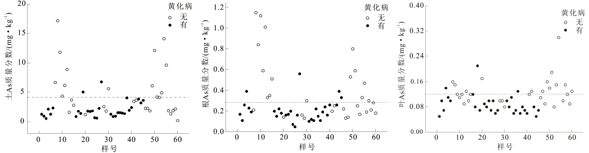
The areca palm is one of the three important "trees" (hevea brasiliensis, areca palm, and coconut) of tropical agriculture in Hainan province, China. However, the areca palm is highly susceptible to yellow leaf disease—the mostcommon disease affecting the palm—which is highly destructive, spreads rapidly, andis difficult to control with comprehensive physical, chemical, and ecological measures. Eco-geochemical studies have focused on the elemental geochemical behavior and ecological effects of the soil-plant system, which may prevent yellow leaf disease in the areca palm. With the support of the People's Government of Wanning City, Hainan Province, an eco-geochemical study was conductedon the areca palm area of Wanning City. Thirty sets of geochemical samples were collected from the root soil, root system, and leaves of areca palms infected with yellow leaf disease, along with samples taken fromhealthy trees. Root soil samples were tested for 28 indicators—including Se, Cu, Pb, Zn, Cd, Hg, As, Cr, Ni, Fe, Mn, B, Mo, Cl, F, I, N, P, K, Ca, Mg, S, Co, Na, Si, Al, pH, and organic matter. Additionally, the plant samples were tested for 23 elements—including Se, Cu, Pb, Zn, Cd, Hg, As, Cr, Ni, Fe, Mn, B, Mo, F, I, N, P, K, Ca, Mg, S, Co, and Na. Binomial logistic regression analysisof whether areca palmswere infected with yellow leaf disease as the dependent variable showed that As, B, and Co in the root soil were the main characteristic elements for determining whether the areca palmwas infected. The coefficients of As were negative,while the coefficientsof B and Co were positive, indicatinga lower probability of areca palminfection when the As content is higher and the contents of B and Co are lower.N, Co, and Na in the rootsystemwere the main characteristic elements for determining whetherthe areca palmwas infected. The coefficients of As, N, and Na were negative, while the coefficients of Co were positive,indicating a lower probability of areca palmsbeing infected when the contents of As, N, and Na are higher, and the content of Co is lower. The elements Zn, Hg, Mg, and S in the leaveswere the main factors determining whether the areca palmswere infected. The coefficients of Zn, Hg, and S were negative, and the coefficientsof Mg were positive,indicating a lower probability of areca palminfection when the contents of Zn, Hg, and Sarehigher,and content of Mg content is lower.Statistical analysis also showed that the correct classification rate and chi-square test expressed leaf> root system> root soil, indicating that the differences in elemental contents in the leaveswere the most accurate reflection of whether the areca palmwas infected. Soil is the most important source of trace elements in leaves and roots.From an eco-geochemical perspective, changing the elemental composition of root soil can be prevented, and yellow leaf diseaseamong areca palmscan be controlled.The As indicator did not enter thestatistical model of leaves (but Hg did), indicating that As does not easily reach the leaves or even the fruit of the palm. As is well known,arsenic-containing pesticides and drugs are used for plant pest control and human disease treatment, which indicates that increasing arsenic elements in the root system may enhance the prevention of areca palm from developing yellow leaf disease. Thus, this study provides a new eco-geochemical approach for the prevention and control of yellow leaf disease in areca palms. However, arsenic, as a toxic element, is an important control indicator for soil environmental quality and agricultural food safety. Therefore, systematic field trial studies and evaluations of areca palm root soil and fruits should be conducted to avoid secondary contamination using As; this can prevent and control yellow leaf disease inareca palms.