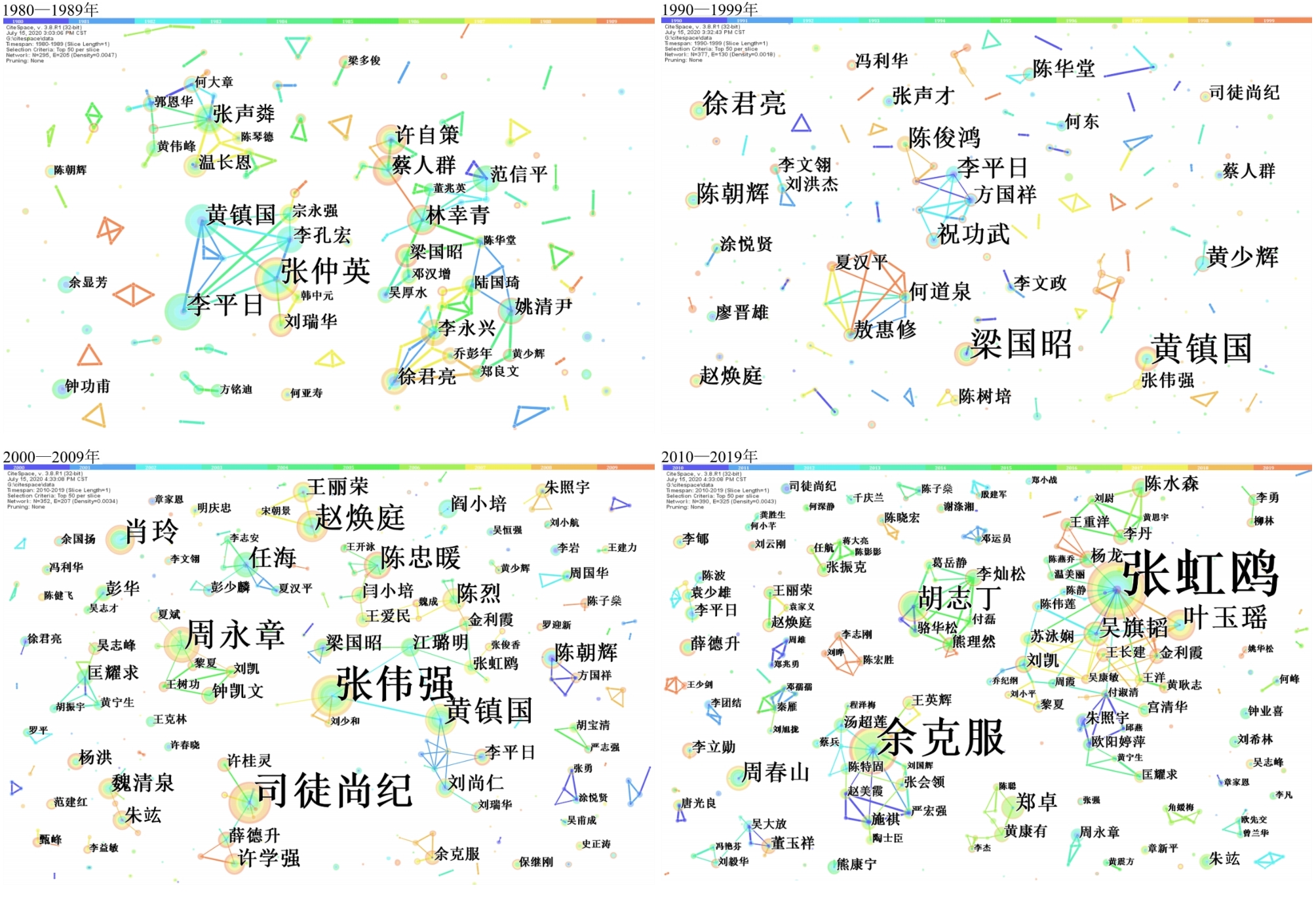
On the 40th anniversary of Tropical Geography, a Bibliometric analysis based on CiteSpace was made on 2 938 articles published in tropical geography during1980-2019. At the interval of every 10 years, this paper conducted keyword co-occurrence analysis, keyword emergent detection, author co-occurrence analysis and institution co-occurrence analysis, aiming to explore the trends of the themes, historical burst terms, the core author partnerships and the core institutions partnerships in Tropical Geography. As a result, in the first 20 years, the research topics and areas of Tropical Geography were concentrated, mostly focusing on south China and the development and utilization of its resources. The cooperation among the core authors was weak and overall dispersed. Besides, it mainly reported the research results of Guangzhou institute of Geography and the cooperation among the core institutions was less. Since 2000, the number of research themes has increased significantly and has formed diversified research hotspots. The research area has been expanded, but it is still concentrated in southern China. More cooperative teams were formed among the core authors, and the inter-team cooperation and communication were significantly enhanced. The proportion of research results of universities and other institutes has increased greatly, and cooperation between institutions has been strengthened also.
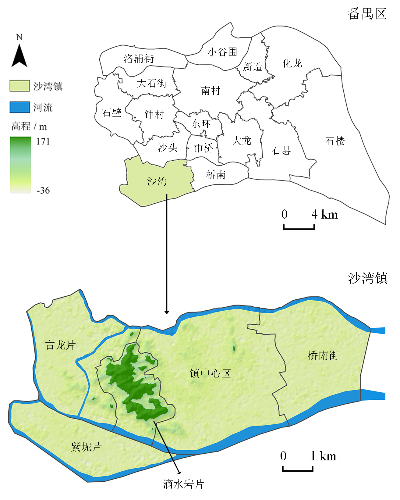
Against the background of the construction of the Guangdong-Hong Kong-Macao Greater Bay Area, the development of ancient towns is faced with new challenges, such as the expansion of urban scale, the weakening of traditional cultural values, the lack of continuity between new and old urban areas, and the inconsistent pattern of old urban areas. This research takes the Shawan Ancient Town, Panyu District, Guangzhou City, as its research object and conducts a spatial syntactic analysis of urban morphology in 2002, 2008, and 2017, based on the axis model. The research shows that: 1) Shawan Ancient Town has experienced three stages of development in terms of overall shape, from "single nucleus cohesion" to "axis growth" and then to "divergence and spread." The town's core has been expanding and its shape has been perfected. 2) The direction of expansion of the ancient town's spatial form is consistent with expansion in the direction of the integrated nuclear center, with which the town's new business is in line. The central transfer is synchronized with the evolution of the spatial form. 3) The phenomenon that the integration core of ancient towns and the development of commercial centers are out of sync is related to modern cities' orthogonal grid form and traditional ancient towns' relatively dense and complex spatial texture. This study reveals the law of development of the traditional village spatial form in the process of rapid urbanization and provides a useful reference for the traditional village's new spatial design and the inheritance and reconstruction of the spatial development structure and order. Finally, the research proposes the following suggestions for the spatial protection of ancient towns: 1) The development of ancient towns should extract the spatial rhythm from the traditional space and follow similar rules to update and develop the town, so as to protect the sense of scale and the traditional daily living space. 2) Good traffic planning can ensure that the original space is only minimally affected. At the same time, the use of transit rail to connect the ancient towns old and new districts can improve continuity between the spaces and ensure efficient operation. 3) Demonstrating the need for the rational control of tourism development., Shawan Ancient Town is in the stage of high tourism development, which makes residents' living space overlap with tourists' visiting space, often resulting in the occupation and destruction of the original settlement space to meet the needs of "others." As a characteristic element of traditional ancient towns, their protection and continuation need to be respected during tourism development. Planning should fully analyze ancient towns' spatial rules and development needs to avoid excessive transformation of the space due to commercial development and the timely restoration of some places worth preserving" if applicable..
With the acceleration of urbanization in China, the transformation from increment planning to inventory planning in large cities has initiated the upsurge of urban village redevelopment. However, this redevelopment has overemphasized the economic benefits while neglecting the social benefits behind the redevelopment, resulting in villagers' difficulties in re-employment, inadequate social security, and other problems regarding citizenization. Taking the Liede redeveloped community as a case study, and using the field theory of Bourdieu, this paper adopts descriptive statistics and qualitative analysis based on data from questionnaires and in-depth interviews to measure urban villagers' level of citizenization after the redevelopment. The level of citizenization is measured through the four dimensions of economic integration, socio-cultural adaptation, structural integration, and social identity. The research indicates that to some extent, although the redevelopment of Liede village has brought new changes to community management, the village collective economic organization continues to undertake a large number of community services and livelihood security functions closely related to the daily life of villagers. The villagers and the village collective have formed an exclusive and closed pattern based on their common interests. Villagers have sought safety strategies for action and decision-making when facing social transformation, and their conservative economic strategies and homogenous social networks have resulted in little changes in the structure and quantity of their capital. In essence, the new village community has not been restructured along with the redevelopment of the physical environment, and the capital of stakeholders is in a relative state of equilibrium, which has not motivated the villagers to adapt to their new environment and reconstruct the structure of the field. After the redevelopment of Liede village, the villagers' living environment improved, their basic rights were secured, and their newly-moved in neighbors also exerted a demonstration effect, which considerably improved villagers' consciousness of their roles as citizens, their behaviors, and their way of thinking. However, many villagers have not achieved self-empowerment or integrated into the urban society, judging from the four dimensions of citizenization. In terms of economic integration, the difficulty of employment persists. Regarding socio-cultural adaptation, the younger generation can effectively adapt to urban society, while the older generation's habits and ways of thinking are solidified. In terms of structural integration, without a platform to interact with other social groups, it is difficult for villagers to expand their social network. Finally, regarding social identity, villagers' social status has not improved with their economic status, and the recognition of their roles as citizens is inadequate. Therefore, the government is advised to promote the transformation of village communities, regard the citizenization of villagers in cities as long-term social work, and carry out community activities and skills training to enhance the human and social capital of villagers, and facilitate their integration into urban society.

Homeownership crucially affects the quality of life of residents and the social stability of society. Therefore, access to homeownership has been extensively studied in the fields of housing studies, human geography, and sociology. In recent years, with the rapid rise in housing prices, China's young generation has been facing obstacles in accessing homeownership, which has attracted considerable attention from the media and scholars. Most of the existing literature centers on the debate of the "market transition theory" and "power persistence hypothesis", which focus on the impacts of market and institutional factors on homeownership acquisition. However, limited attention has been paid to regional variations in the influencing factors. There are widening differences in housing prices, housing purchase regulations, and demographic structures between cities and regions, which may result in variegated effects on the young generation's access to homeownership. To fill this gap in literature, this paper re-visits the "market transition theory" and "power persistence hypothesis" by comparing Shanghai and Nanjing, which are first-tier and second-tier cities, respectively, within the Yangtze River Delta. Based on the Yangtze River Delta Social Transformation Survey and Nanjing Housing Survey in 2013 and employing logistic regressions, this study investigates the factors that affect the young generation's housing tenure and the differences between the two cities. The results show that there are greater location differences within the city and more institutional barriers compared to Nanjing. The young generation's access to homeownership in Shanghai is associated closely with residential location, hukou status, and being a communist party member working in the public sector. In contrast, market factors such as educational attainment, job mobility, and demographic factors, including age and whether one is a parent, exert relatively little influence in Shanghai, but have significant influence in Nanjing. This study contributes to deepening our understanding of the regional variations in factors that influence homeownership acquisition among China's young generation. Furthermore, it sheds light on the implementation of the "different policies for different cities" strategy and the establishment of a long-term effective regulation system for the real estate market.
Commercial space structure is an important research focus of Urban Geography. Analyzing the spatial distribution of urban commerce is of great significance to urban planning management, within which spatial distribution patterns of the catering industry have always been a focus of research. Quantitative analysis of the catering industry's spatial pattern and influencing factors using big data is a primary trend in recent research. This paper uses Shanghai as a case-study. Based on POI data and using GIS spatial analysis methods and spatial regression models, the spatial distribution patterns, influencing factors, and internal heterogeneity of different catering industry types are investigated. This paper's conclusions are useful for understanding the influence of urban internal spatial elements on the catering industry's spatial pattern. It also provides a location selection reference for the catering industry and analyzes residents' consumption behavior. We find that the catering industry is clustered and multi-centered, and concentrated in the central urban area. The foreign catering industry is highly concentrated within the inner ring, extending from east to west. The fast-food industry is primarily agglomerated in central areas and rural-urban continua where universities cluster. We use a spatial error model to analyze the influencing factors, finding that the catering industry distribution is influenced by four factors: population, economy, transportation, and space. A larger population provides for more consumers in the catering industry, and the spatial concentration of the population can promote the creation of more catering companies. The catering industry tends to assemble in areas with a higher level of regional economic development. Superior transportation conditions can attract catering companies, but the influences of transport facilities differ. Parking facilities and bus stations are vital to the catering industry. In terms of macroeconomic location, catering industries concentrate around regional centers. Densities of catering companies within the inner ring are significantly higher than those outside. The density of catering companies does not show a significant difference between new towns and the Puxi area. Regarding the micro-built environment, the clustering of public, leisure, entertainment, and cultural facilities positively impacts the distribution of catering companies; however, the degree of diversity of surrounding industry types negatively impacts agglomeration. There are also differences in the factors affecting the catering industry's four distribution types: Chinese food, western food, fast food, and dining establishments. Western food companies tend to be located in areas with higher land prices. Chinese food companies have a greater demand for traffic accessibility. The distribution of dining establishments corresponds significantly to the level of local economic development. The distribution of fast-food companies is closely related to cultural and entertainment public facilities. We extrapolate the relevant theories of urban commercial space structures, providing theoretical support to facilitate the catering industry in choosing company locations and conduct future urban planning.
Since the late 1980s, Taiwanese investment in Mainland China's agriculture has grown rapidly. As the main form of cross-strait agricultural cooperation, Taiwanese investment has greatly promoted the development of the agricultural economy of Mainland China. However, the question that follows is whether these Taiwanese-funded agricultural enterprises can embed themselves into the local network in order to drive the sustainable development of the region. At present, the academic community pays little attention to this issue. Therefore, following on the theory of embeddedness and the theory of relational economic geography, this study takes the Taiwanese-funded high mountain tea industry of Yongfu Town as an example. Field research and in-depth interviews were used to construct a framework of industrial embedding analysis from the perspective of the agents' relationship with each other, focusing on an analysis of the dynamic embedding process and related mechanisms in the Taiwanese-funded high mountain tea industry of Mainland China. The results showed the following: 1) The embedding of the Taiwanese-funded high mountain tea enterprises of Yongfu Town is a gradual process that can be divided into social, network, and geographic embedding. Among these, social embedding is the premise of embedding activities; network embedding is a further development of social embedding and the most important form of embedding; and geographical embedding constitutes the spatial background for both social and network embedding activities. These three steps are interconnected with and promoted each other, and together, they constitute the spatiotemporal scene of enterprises' socioeconomic activities. 2) The three relationships of Actors-Institutions, Actor Networks-Inter-Organization Networks, and Local-Global are intertwined with each other throughout the embedding process of the tea enterprises of Yongfu Town and profoundly affect the process and results of the embeddedness. In addition, the study also found that local governments and intermediary agencies play an important role in promoting the development of enterprise and network reorganization. In this regard, this research suggests that local governments pay attention to the cultivation and growth of enterprises that support the local community and simultaneously encourage further exchanges among enterprises and promote network integration to continuously improve the degree to which Taiwanese-funded high mountain tea enterprises are "embedded."
With the shift to the "post-rural" study of rural geography, the mixture of urban, rural, and hybrid environments has become the focus of rural geography. Rural community empowerment, the active intervention of urban and rural elements, promotes the establishment of sustainable rural autonomy. Taking the Zhonghe rural community in Taizhong as its case, this paper discusses the influence of social structures and individual actors on the formation of placeness through the two perspectives of social construction and humanism, and it explores the construction mechanism of community empowerment. The results are as follows. 1) The placeness of Zhonghe community empowerment is reflected in the location of rural suburbs, the practice site and activities of community construction, and the sense of place of participants and tourists. 2) The process of placeness construction is formed by the interaction between social objects and behavioral subjects in three stages. 3) Weak placeness causes reflexivity in the behavior body and the social object, which constitutes the basis of community empowerment. 4) The government has established a mature operation mechanism to promote community empowerment, which participants also promote according to the needs of daily life. This, in turn, promotes placeness production and reproduction, forming a continuous process of community building. 5) The results of placeness construction attract the reinvestment of human and economic capital inside and outside the community, which ensures the sustainable power of community empowerment. 6) Through community empowerment, a sustainable, pluralistic, and global place is created in the rural environment, which cultivates a collective identity and community cohesion, indirectly strengthening the capabilities of rural autonomy.
Compared with other regions, there are more low-quality pixels in the Normalized Difference Vegetation Index (NDVI) of cloudy and rainy areas in terms of temporal and spatial distribution. This would increase the difficulty of reconstructing a high-quality NDVI in cloudy and rainy areas. Guangdong Province—located in the subtropical monsoon region of southern China—is a typical cloudy and rainy province with a high intensity of human activities. Therefore, it is particularly significant to study vegetation change and the response of vegetation to human activities in Guangdong and reconstruct a high-quality NDVI within it. To verify that a weighted smooth spline (sspw) can reconstruct a high-quality NDVI in cloudy and rainy areas and provide reliable data for follow-up studies, this paper takes Guangdong Province as an example and uses MOD13Q1 NDVI from 2000 to 2005 to reconstruct its NDVI. Further, to verify the reliability of the NDVI reconstructed by sspw, the results are compared with those of smooth spline (ssp), Savitzky-Golay (SG), and weighted SG filter (SGw). The following conclusions were drawn. First, compared with SGw, sspw, and SG, sspw-reconstructed NDVI had the largest number of strong correlations and low error pixels. In the correlation coefficient results, 41% of the NDVI pixels reconstructed by sspw had a correlation coefficient of more than 0.7 with the original; in the root mean square error, 64% of the NDVI pixels reconstructed by sspw had an error of less than 0.1 with the original. In terms of Akaike's Information Criterion (AIC) and Bayesian Information Criterion (BIC), the NDVI reconstructed by sspw had 41% of all pixels' AIC < 197 (lower AIC) and 52% of all pixels' BIC < 235 (lower BIC), respectively. This indicates that sspw can reconstruct a high-quality NDVI in cloudy and rainy areas. Second, while the NDVI curve characteristics of typical sample points can be used to determine the reasonable range of the spar coefficient, spar = 0.25 is more suitable for NDVI reconstruction in Guangdong Province. Third, compared with the unweighted ssp and SG, the NDVI time series curve reconstructed by sspw and SGw with quality weight is closer to the original value. Finally, compared with the NDVI reconstructed by sspw, in cloudy and rainy areas, the NDVI reconstructed by SG and SGw will retain some noise and abnormal values in the low- and high-value parts. Therefore, sspw is more suitable for NDVI reconstruction in cloudy and rainy areas.
Against the backdrop of global warming, the structure and patterns of precipitation have changed significantly. This includes changes in the non-uniformity of spatial and temporal distribution of precipitation, while the frequency of extreme precipitation events has increased. Studies have shown that regional drought and flood disasters are related to rainfall and also closely related to the frequency and intensity of precipitation. As the main climate factor, the spatial and temporal variation in precipitation for different grades has become of significant research interest in recent years. Based on daily precipitation data from 1960 to 2017, this study used the Mann-Kendall non-parametric test and R/S analysis (rescaled range analysis) to analyze characteristics of spatial-temporal variation for precipitation at different grades in the Taihu Lake Basin for the past 60 years. Additionally, these results were used to explore the impacts of this variation on the annual precipitation. The observed daily precipitation (P) was categorized into four grades of intensity: light precipitation (0.1≤P<10 mm/d); moderate precipitation (10 ≤P<25 mm/d); heavy precipitation (25≤ P<50 mm/d); and storm precipitation (P≥ 50 mm/d). These classification criteria have been used in many global precipitation analyses. The results show that the annual precipitation days were dominated by light rain days, accounting for 73.55% of the total annual precipitation days between 1960 and 2017. The contribution rate of light rainy days to the total annual precipitation days had significantly reduced, and the contribution rate of heavy rainfall to the total annual rainfall had significantly increased. There was a significant increase in the rainfall, rainy days of heavy and storm rain, rainfall intensities for light rain, and the annual average precipitation. The number of light rain days had decreased significantly, and the precipitation structure in the Taihu Lake basin showed a tendency to shift to extreme heavy precipitation. There were significant differences in the spatial distribution of precipitation trends for different grades. The light rainy days, total annual precipitation days, and intensities of light rain and annual average precipitation showed a similar spatial pattern in the changing trend. The light rainy days and total annual precipitation days showed a significant downward trend across the entire basin, while the intensities of light rain and annual average precipitation showed a significant increasing trend. The spatial distribution of the change in the days of moderate rain, heavy rain, and storm rain were similar to the corresponding spatial pattern of rainfall. R/S analysis showed that, in addition to light rainfall, the indicators related to light rain, heavy rain, and annual total precipitation showed strong persistence, and the future trend was consistent with that of the past. In the past 60 years, the annual total rainfall, precipitation days, and annual average precipitation intensity in the Taihu Lake basin were greatly affected by moderate rainfall, light rain days, and heavy rainfall, respectively. The annual precipitation reduction was greatly affected by the decrease in heavy rainfall in dry years, and the increase in annual precipitation was heavily impacted by the increase in storm rainfall in flood years. There is a need for further study on the climate dynamic mechanisms underpinning different precipitation grades, such as atmospheric circulation and water vapor transport.
Fractal theory can be used to reveal the fractal features of many geographic phenomena, and the composition of sediment grain size has been successfully applied to the study of the evolution of geographic environments. The fractal dimension has widely been used as a new grain size index, which is consistent with the environmental changes reflected in the traditional analysis of grain size and composition; however, whether the fractal dimension can also reveal environmental changes in the Poyang Lake area in the mid-subtropics has not yet been determined. This study analyzes the fractal dimension characteristics of Houtian sandy land based on the results of grain size and the power of the exponential function relation method in fractal theory. A series of dune sand-sandy paleosol sequences were developed intermittently on the terraces of the lower reaches of the Ganjiang River. Based on multiple comprehensive investigations, the Houtian section, with rich sequences and a relatively continuous deposition, was selected in Houtian sandy land, Xinjian County, and Nanchang City. With the research carried out, Optically Stimulated Luminescence (OSL) age and grain size tests were completed. A comparison of the fractal dimensions with clay, average grain size, winter and summer monsoon intensity-sensitive grain size, and the Nanjing Hulu Cave stalagmite oxygen isotope gave the following results: 1) Combined with the results of OSL dating and deep-sea oxygen isotope and stratigraphic characteristics, an age-depth framework was constructed based on the segmented sedimentation rate interpolation. The sand dune-sandy paleosol sequence of the Houtian section was mainly formed during the last glacial period (14.9-77.0 ka). The entire section has a good fractal structure, with the dune sand's fractal dimension at 2.04-2.62 (average 2.34) and the sandy paleosol at 2.24-2.70 (average 2.51). 2) The fractal dimension is positively correlated with the summer monsoon intensity-sensitive grain size, negatively correlated with the winter monsoon intensity-sensitive grain size, and closely related to the standard deviation (whereby the smaller the standard deviation, the smaller the fractal dimension). Medium silt, coarse sand, and winter monsoon intensity-sensitive grain size content are higher during the developmental period of the dune sand, and the average grain size is thicker. The standard deviation is smaller, the sorting is better, the degree of self-organization is higher, and the fractal dimension is smaller during the development period of the sandy paleosol. Due to the warm and humid climate, the weathering pedogenesis is stronger; the content of clay, fine silt, and summer monsoon intensity-sensitive grain size has increased significantly; the average grain size is finer; the standard deviation is larger; the sorting is worse; the self-organization is lower; and the fractal dimension is significantly larger. As a result, clay and fine silt formed by weathering sedimentation have the most significant impact on the fractal dimension. 3) The fractal dimension shows some alternating peak-valley cycles in the vertical direction. The peak values correspond to the early MIS2, MIS3c, and MIS3a stages, indicating a strong summer monsoon and a warm and humid climate; the valley values correspond to the late MIS2, MIS3b, and MIS4 stages, indicating that the winter monsoon is strong, and the climate is dry and cold. The results indicated that three climate warming cycles have occurred in the Houtian sandy land. At the same time, the fractal dimension reveals that the H5 and H6 events, which occurred in the HTS3b and HTS4 stages, show that the winter monsoon is the strongest and the summer monsoon is the weakest. Further, the sequence of aeolian sand deposition in the Poyang Lake area is practically synchronized with global climate change and extreme cold weather events.
Based on panel data of 18 sample villages and 612 farming households in Xishuangbanna, Pearson correlation coefficients were used in this study to measure the degree of fit between the two stages of "input-output" structure across six years, in 2012-2014 and 2014-2018. We measured changes in farmers' rubber dependence in the main producing areas and analyzed the core influencing factors based on a Tobit model. The results are as follows. 1) Rubber dependence in the main rubber production areas is decreasing. With the reduction in rubber dependence, China's domestic rubber supply will decrease, and China's rubber import dependence will increase, posing a threat to industrial security. 2) Rubber dependence fulfills the assumption of a self-reinforcement mechanism. The degree of dependence on rubber output has a pass-through effect, indicating that rubber dependence can be regulated against the trend. Therefore, policy subsidies can be used to enhance input incentives to increase rubber dependence in this period and the next, which will effectively guarantee the scale of rubber supply. 3) Increasing returns do not necessarily lead to rubber dependence. Farmers pay more attention to anticipated future income, and raising the expected income can guarantee the willingness of farmers to grow rubber. 4) Rubber dependence is manifested as land dependence. The land has "special asset attributes" after planting rubber, and changing the planting structure demands great time and capital costs. 5) Rubber dependence is also manifested as altitude dependence. In low-altitude areas that mainly supply rubber, the time cost for farmers to adjust the scale of rubber planting is relatively small, and it is easier to destroy rubber forests. Low-altitude areas should be the focus of rubber industry policy. Rubber is an important strategic resource. Once farmers begin large-scale felling of rubber trees, the waiting period to resume production will be longer, which could easily put China's rubber industry in a passive position. Therefore, it is recommended that during the period of low rubber prices and the gradual decrease in regional rubber dependence, appropriate industrial support should be given to farmers to prevent a sudden drop in the scale of rubber supply and ensure the safety of the national rubber industry.
Sensitivity and risk assessments are not only effective methods for disaster prevention and alleviation but are also important bases for scientific spatial planning and regional environmental policy-formulation. To further strengthen the integrated management of coastal zone and explore more efficient methods of ecological space control, ten factors, namely soil erosion, desertification, soil salinization, typhoon disaster, rainstorm and flood disaster, special habitat, storm surge, disastrous wave, coastal erosion, and red tide, were selected to evaluate the eco-environmental sensitivity of the coastal zone in Lingao County, Hainan Province. Earthquake, collapse, landslide, land subsidence, and sand liquefaction were considered in the risk assessment of geological hazards. The results derived from eco-environmental sensitivity and risk assessment of geological hazards were combined with territorial planning to analyze the deep spatial management zoning of the study area. The results indicated that: 1) Desertification, soil salinization, rainstorm and flood disaster, red tide, and coastal erosion were mainly slightly sensitive; soil erosion and typhoon disaster were mainly moderately sensitive; and special habitat, storm surge, and disastrous wave were highly sensitive. The area of moderate, high, and extreme-high comprehensive sensitivity zone was 9 682.11, 3 275.29, and 983.88 hm2, respectively. Among them, Diaolou Town had the largest distribution area in the highly sensitive zone, and Bohou Town had the most widely distributed area in the extreme-highly sensitive zone. 2) The main geological hazards were earthquake, collapse, landslide, land subsidence, and sand liquefaction. Except for the seismic risk, which was divided into high-risk zone and middle zone, the other four types only had medium-risk and low-risk zones. The comprehensive risk zones were classified as high, medium, and low, among which the risk areas were mainly distributed in the 15 m area on each side of the fault zone of Bohou, Dongying, Bolian, and Huangtong Town, with a total area of 118.86 hm2. 3) The development and utilization of the coastal zone in Lingao County may be divided into three levels. The first level includes specific protected zone, moderate development zone, and intensive development zone. The second level included eight zones, including natural reserves, retention zone, utilization zone in control, agricultural development zone, tourism and leisure zone, public facility zone, residential construction zone, and industrial zone. The third level consisted of 18 tertiary divisions. 4) The deep spatial management zoning of the coastal zone with multiple horizons of ecological sensitivity, geological hazard risk, and territorial planning can better identify important protection objects and key protection areas and enable the coastal zone to be fully developed and utilized. Although this paper attempted to diagnose and identify the intensity and spatial distribution of various eco-environmental sensitivity types in the coastal zone from the views of quantification and visualization, some problems need to be explored further in the process of application, such as index selection, model construction, data acquisition, synergistic influence among different ecological environment sensitivity types, and so on. Moreover, the visual expression of geological hazard formation mechanism in the coastal zone and the commonness and individuality of the quantitative measurement of potential geological hazard risk assessment are also aspects that need to be strengthened.
After 40 years of rapid development, China has produced incredible economic results at the heavy cost of resources and the environment. Although research on this has attracted increasing attention, no unified paradigm has been formed so far. Additionally, the mechanical exploration of the interaction among socioeconomic factors, resources, and the environment is still weak, and conclusions lack operability, which makes it difficult to provide effective decision-making support for industrial development. This study focuses on the relationship among industry, population, resources, and environmental factors in order to construct a comprehensive evaluation framework to be applied to Hainan province. The framework first evaluates the importance of industries and then analyzes the quantitative relationship among regional industries, population resource consumption, and the intensity of pollution emissions. Finally, it sets different adjustments to the industrial structure based on the industrial and population resource consumption and the intensity of pollution emissions to evaluate the resource and environmental carrying capacity of different industrial structures (that is, the upper limit of the scale of industry and population). The results show that the current economic scale of Hainan province is not overloaded, and there remains room for further industrial development. For example, land resources have become the primary limiting factor for the development of Hainan province, followed by the water environment. Most pillar and basic industries with higher economic benefits are highly water-consuming and polluting industries. There is an urgent need to reduce the use of water resources as well as the intensity of pollution emissions. To further enhance economic development, it is necessary to cultivate industries with low energy consumption and low emissions. The evaluation method of resource and environmental carrying capacity constructed in this study holds clearer policy significance and can provide decision-making references for optimizing industrial structure adjustments while controlling the scale of industry and population development. This study further connects the theoretical research and practical application of resource and environmental carrying capacity, improves the operability of the research results in terms of decision-making support, and provides methodological references for the evaluation of resource and environmental carrying capacity. Future research challenges were also discussed. With respect to the specific application of the model, it is more meaningful to focus on the relative value of the model evaluation results (that is, differences among development scenarios) instead of the absolute values of each scenario.
In the backdrop of slow growth in traditional industries, the marine economy has gradually become a new bright spot for economic and social development in various countries. As a new institutional model of island development and island economic development in China, "international tourism island construction" bears the important responsibility of promoting the coordinated development of regional economy and the marine development strategy. The existing research on the economic development of China's islands focuses on the development strategies that include: "what an international tourism island is" and "how to build an international tourism island." Few empirical studies focus on the specific preferential policies such as tax exemption for outlying islands, and there is no systematic study on the economic growth effect of the construction of international tourism islands. This leaves many questions unanswered regarding the economic development system model of international tourism island construction. Using the policy practice of Hainan Province in 2010 as a natural experiment, based on the provincial panel data of China's mainland from 1996 to 2017, the economic growth effect of the construction of the international tourism island is measured using the synthetic control method, and its influence path is analyzed. The results showed that: 1) the synthetic control method can well fit the economic growth path of Hainan Province before the implementation of the construction of international tourism island, and they confirmed that the construction of the international tourism island can effectively promote the economic growth of the Hainan area; 2) the construction of the international tourism island, indeed, promotes the economic growth of Hainan through the consumption and investment path on the demand side, and the tertiary industry development path on the supply side; 3) the net export and the secondary sectors of the construction industry are not the influence paths of Hainan International Tourism Island construction to promote local economic growth. This shows that the institutional model of promoting the economic development of the island area through the construction of the international tourism island conforms to the development principle of China's construction of a new pattern of domestic circulation dominated by domestic and international mutual promotion, and strongly refutes the misconception that the construction of the Hainan International Tourism Island is failing to promote internationalization, or that the Hainan International Tourism Island construction relies on real estate to develop the economy. This paper identifies the economic growth effect and influence path of Hainan International Tourism Island construction, makes up for the lack of quantitative analysis of international tourism island construction research, and, based on the empirical results, puts forward policy suggestions to improve the construction of an international tourism island and an institutional model experience that can be replicated and promoted in other island areas to serve the economic development of China's islands and the strategic practice of maritime power.
With the influence of global warming, changes in climate suitability have become one of the most important factors that affect tourist satisfaction. The Nanshan Cultural Tourism Zone in Sanya City was selected as the study area. The thermal comfort of tourists was subjectively evaluated with a random questionnaire survey and objectively through the Net Effective Temperature (NET), which was based on 1960-2019 daily meteorological datasets that included air temperature, relative humidity, and wind speed data obtained from 756 meteorological stations. The spatial differences in thermal comfort with long-term and/or short-term climate memory were discussed with respect to the theory of neutral state deviation. The results showed that there were significant differences in sex and age, and the risk of thermal stress in young women wasis the highest. None of the differences that emerged between men of different ages were substantial. The heat tolerance of young men was significantly higher than that of young women. With increasing age, the incidence of high thermal stress showed a significant linear decreasing trend. In addition, the proportion of high thermal stress at the province scale was classified and discussed. In category I (high risk, including eight provinces), the ratio was 75% with higher long-term NETs and increased to 88% with lower long-term NETs. In contrast, in category II (low risk, including 14 provinces), the ratio was 75% with higher long-term NETs and decreased to 63% with lower long-term NETs. The neutral state of thermal stress has a more obvious short-term memory bias. We discovered that the correlation between long-term climate state and the proportion of high thermal stress was weak. The lower the temperature in tourist source destinations, the greater the proportion of high thermal stress was. This is consistent with the hypothesis of neutral state, which verifies that the neutral state of thermal stress has a more obvious short-term climate memory bias. It is worth noting that the 9-day short-term memory leads to the most significant neutral state deviation. Compared to the air temperature, the NET had a stronger spatial consistency. We noted that it is easier to identify the neutral state deviation of thermal stress with the NET, and the NET is more suitable for the quantitative assessment of thermal comfort. This study detailed the influence of climatic factors on tropical coastal tourism and revealed that the short-term climate memory of tourist source destinations is a crucial factor affecting the thermal stress deviation of tourists. Based on the analysis results, the tourism market can be subdivided according to the differences in thermal stress between different tourist groups in the off-season, and could be influenced through various processes, such as strengthening the publicity for off-season tourism in low-risk tourist source destinations (Category II, 14 provinces), designing tourism products according to age and sex, and transforming short-term sightseeing tourism into holiday-oriented medium- or long-term tourism. These targeted suggestions can provide important practical guidance for optimizing the management and marketing strategies of local scenic spots in off-season tourism.
This study analyzed the American scenic byway policy evolution process from five aspects, namely policy evolution background, policy types, policy subjects, policy themes, and policy instruments. On this basis, the authors described and identified its evolution to provide some enlightenment and references for the construction and improvement of China's scenic byway policy. The results showed that: 1) the American scenic byway policy evolution process has gone through four periods, namely germination, initial exploration, growth and development, and transformation. This is a historical process of dynamic evolution and a landmark policy promotes historic turn. 2) The evolution of scenic byway policy in United States is influenced by various internal and external factors, such as social civilization and ideological trends, economic and ecological environment development, traffic construction and tourism demand, and the development of the scenic byway itself, which promote historical policy change through interaction and mutual driving. 3) The Act, technical guide, and research report are a triad that jointly promotes the evolution of the American scenic byway policy. Among them, research reports are the premise, acts play a guiding and leading role, and technical guides are practical. 4) After one hundred years of changes, America has formed a structure of policy-making, which is dominated by the transportation sector, united by multi-sector and cross-sector, and and participated by the public. The special scenic byway management organization has been established at the national level (National Scenic Byways Advisory Committee). 5) The United States has formed a relatively complete and practical value scenic byway policy system, which involves "construction, management, maintenance, and transportation" and provides comprehensive policy support and institutional guarantees. Finally, this paper proposed that China should follow the general law of the evolution of scenic trail policies, consider various internal and external factors, further enrich policy types, incorporate the scenic byway into China's national calendar system as much as possible, establish national-level scenic byway directorate or leading department as soon as possible, and pay attention to the whole process of "construction, management, maintenance, and transportation", based on the experience of the United States, combined with the current situation and problems of China's scenic byway policy.
Urban functional space renewal is an important means of revitalizing urban spaces, regenerating human memory, and reshaping spatial vitality in the new era; it is the core engine of sustainable urban development. In this paper, first, based on the development history of western urban renewal, we defined the concept and connotation of urban function renewal, and then systematically reviewed the research on urban function renewal at home and abroad; we focused particularly on the background and succession trajectory, function renewal models and spatial organization, research paradigm and space judgment, and driving mechanisms and planning regulation. Importantly, we discovered that the urban function renewal trend is closely related to the economic and social development level and the urbanization stage. Moreover, the urban functional renewal operation mode was observed to reflect the tendency of diversified cooperation between the governments, private sector, and communities. Additionally, the urban functional renewal judgment showed the tendency of multi-source data fusion and identification, and the urban functional renewal strategy was shown to be affected by multiple factors, such as policy control, the driving economic force, and market mechanisms. Particularly, with respect to the transformation and adjustment of the urban development in China in the new era, research on urban function renewal focuses more on the scientific cognition of urban renewal practice, the refined turn of spatial governance capabilities, and the humanistic return of governance concepts. Importantly, this paper focused on some hot topics of the urban function space research and has presented an in-depth discussion and analysis of issues, including the construction of the theoretical system and practical framework of urban function renewal in the new era; the succession characteristics of functional business research, and the regulation of localized policy were also addressed. Of note, existing research studies mainly qualitatively describe and analyze the update mode of a single function type at the macro-scale of cities and regions; reports on multi-temporal cognition and objective evaluation of business succession under the microscopic view are still insufficient. For this reason, we proposed that the renewal of urban functions in China should, in the future, pay more attention to the micro-spatial scale, especially the multi-dimensional quantitative analysis of the renewal mode of fine urban functions. Additionally, the integration of systematic research ideas should be considered for the generation of comprehensive methods to condense a universal, representative, and complete theoretical system of urban function renewal.