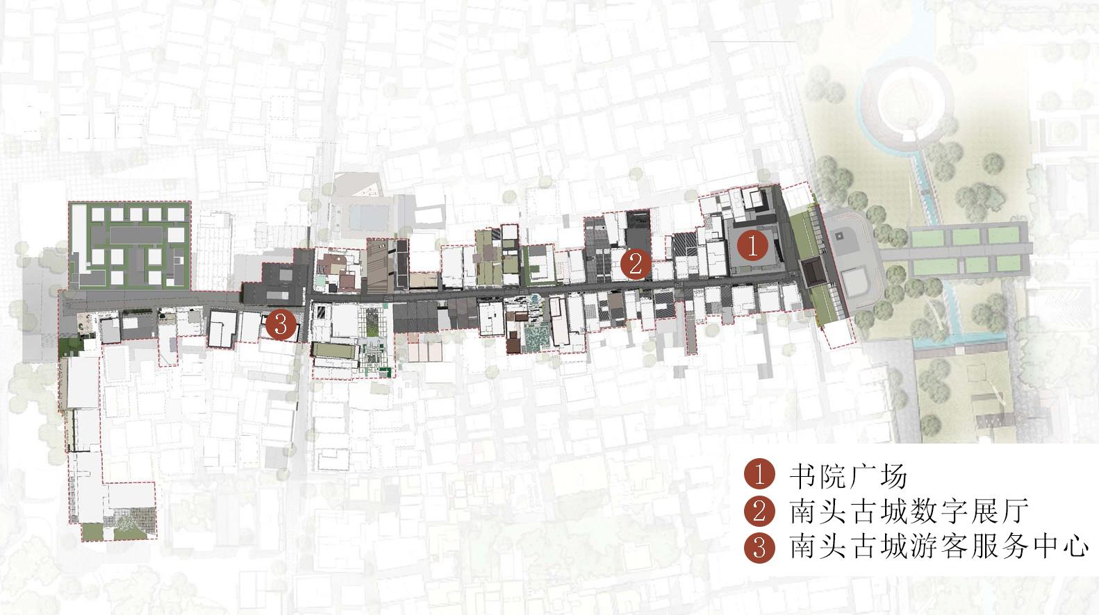
With a strong emphasis on historical heritage and culture-making, culture-led redevelopment has become an important policy in many megacities to revitalize declining areas, such as urban villages. However, local governments have different understandings of cultural development and historic preservation and often take them at face value while ignoring the internal mechanisms. For cities of migration, cultural identity has richer connotations. The time-space nexus between the origins and destinations of migrants is highly significant for fostering a diverse and more inclusive urban culture. Taking three urban villages in Singapore and Shenzhen as empirical cases and using the theoretical perspective of cultural identity, this paper explores the culture-making process in the redevelopment of urban villages. We argue that the essence of cultural identity lies in social relations, not merely in visual symbols and images, and understanding cultural identity requires comprehending the relations between the global and the local, as well as between the past and the present embedded in places. The paper starts with an interpretation of the culture-led macro policy, followed by an analysis of urban redevelopment's internal political and economic driving forces. Based on data from participant observation and semi-structured interviews in both cities, a qualitative analysis on the modality, mechanism, and influences of identity-making in urban village redevelopment was conducted. Research findings include differences in the dominant stakeholders' attitudes toward cultural identity, especially migrants' identity, in the redevelopment modalities in the two aforementioned cities. These differences have led to different outcomes. The case of Singapore's Geylang Serai Village centered on the living needs and activities of Malay migrants, who were the main residents there, to conduct the regeneration. Further, the Housing and Development Board (HDB) issued a policy to ensure residents' housing rights. Therefore, the program maintained the continuity of the existing community by protecting the spontaneously formed identity while developing the showcase economy based on simultaneous market activities. Regarding Shenzhen, developers of Nantou Ancient City and Gankeng Hakka Town focused on specific historical periods and designated the architectural style as the local characteristic in order to develop the tourism economy. However, the top-down imposed identity had little to do with the migrants' community, which led to their exclusion and broke down their established social networks, indicating that the mere focus on beautifying the physical environment will lead to gentrification catering to middle-class aesthetics. The study findings point to the conclusion that the designation of the cultural identity of a place is, effectively, the use of cultural capital. The voice of identity in cultural discourses represents the social right of a community to urban spaces. Therefore, culture-led urban village redevelopment should focus more on local communities' social relations and actual needs in order to promote a more just, inclusive, and sustainable urban redevelopment.
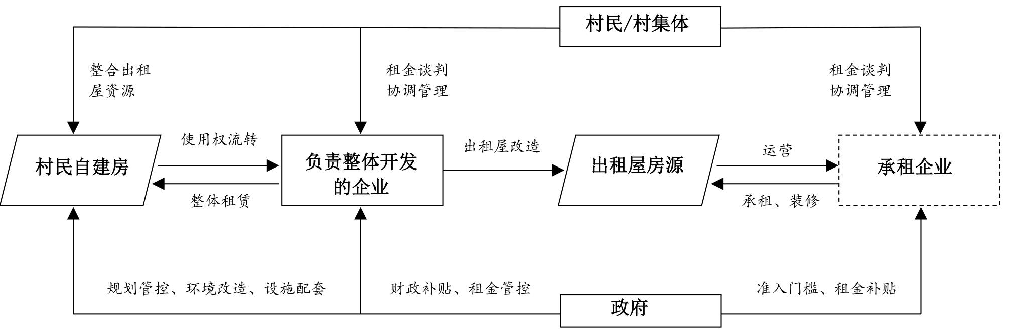
Drawing upon the existing literature and practice, the study revealed two main ways to renew urban villages, namely demolition and reconstruction and on-site rectification. However, it is challenging to meet the sustainable development needs of the city regarding economy, society, and environment using these approaches. Accordingly, they have become the key factors restricting the process and effect of urban renewal. Therefore, this study introduces the theory of sustainability science, draws lessons from the three-dimensional analysis framework of "object-subject-process" in management science, and establishes the research framework of sustainable renewal mode in urban villages by taking communities and individual projects as the spatial scale of research. This model emphasizes several dimensions. The object dimension entails pursuing economic and social prosperity under the premise that the key natural capital is not reduced. The process dimension consists of conducting the whole process reform of the causal chain. The main dimension encompasses pursuing the cooperative governance of the government, enterprises, villagers, and village collective. The empirical study of Huanghe Village in Hou Lake, Changsha, was planned by the government, contracted by enterprises, and coordinated by village communities through house preparation. In addition, this paper evaluates the renewal path of "moving but not demolishing and overall development and comprehensive renovation" from the perspective of sustainable development. The results show that the model has a positive impact on balancing the interests of multiple parties, revitalization of the stock of land resources, promotion of the upgrading of industrial structure, improvement of the urban space quality, and protection of the village culture. However, since the model does not involve the changes of the property rights of farmers' self-built houses, it is difficult to fundamentally solve the historical problems originating from the process of urban village renewal, such as the transformation of farmers' citizenship status and farmers' livelihood risks. In addition, the case selected by the empirical study is specific in terms of the location and evolution process, which may directly affect the copy effect of the case. Nevertheless, this study is an attempt to interpret the practice of urban renewal using the theory of sustainability science, which provides new insight into promoting the sustainable renewal of urban villages, as well as experiences in China.
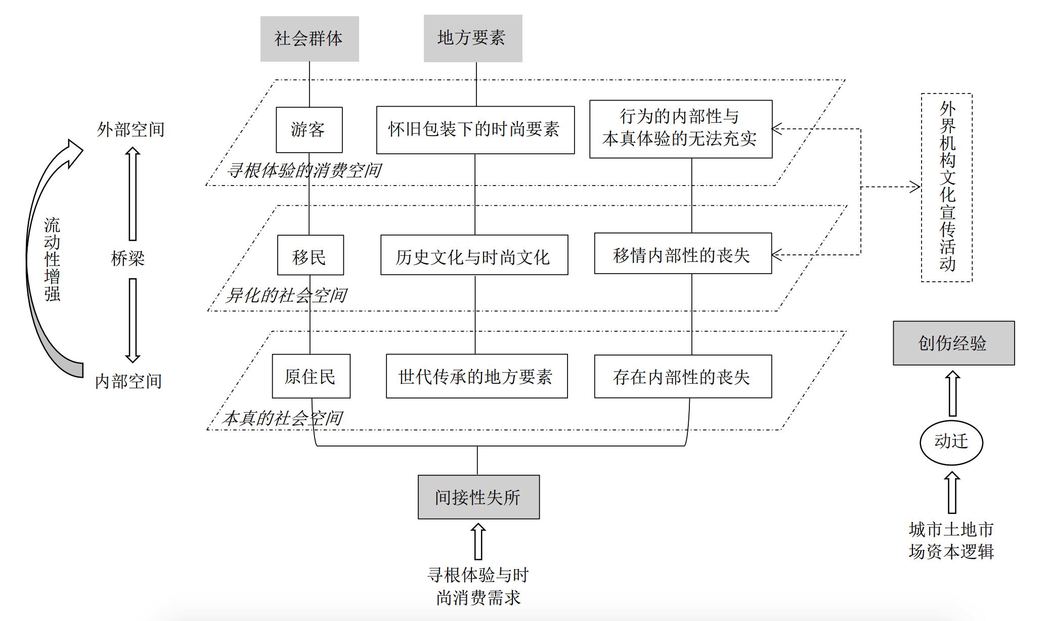
With the transformation from a focus on material spaces to spatial experiences within the field of gentrification-displacement, the lifeworld constituted by daily experiences was the fundamental starting point of this study. Daily experiences as such do not only refer to unconscious universal experiences but also contingent ones, so that the lifeworld at issue is a field of care as well as a field of suffering simultaneously, within which both rootedness and rootlessness are concerned. Therefore, the field of displacement integrates into the frame of Lefebvre's spatial triad in such a way that the lifeworld at issue is manifested as representational space and spatial practice. The lifeworld, as a pivotal concept of phenomenology, as well as the spatial triad can both be seen to merge into the field of displacement and further induce the transformation of the focus from direct displacement to indirect displacement, which regards daily experiences as its base. Meanwhile, a qualitative analysis of local symbols, within which local agencies act and react, has been adopted in this study field as an effective spatial practice in the production of representational space. Representational space as one side of the spatial triad tends to be regarded as the opposite side of spatial representation, in many cases, and both are linked by spatial practice. Within the frame of spatial triad, this study mainly concerns the experiences of lifeworld stemming from gentrification-displacement which is regarded as the representational space represented through the locals' practice. Based on the theoretical context in question, the authors conducted an investigation of gentrification-displacement experiences in the Xiahao community of Nan'An District of Chongqing, which is a very typical historical and cultural district confronting displacement by tourism gentrification. In addition, another item by Lefebvre, "social space," was also included in this study to place a stronger emphasis on hierarchical social groups catering for this case study on recognition, action, and emotion at a local level. The findings of this study included two main aspects. First, the displacement experiences were demonstrated by distinguishing the features within three main social groups: residents, migrants, and tourists. (1) Residents' experiences comprised the loss of memories related to their own families' life history in the long term as well as the disappearance of the routine of intimate interpersonal relationships in the neighborhood. (2) The displacement experiences of migrants were manifested as the loss of a free lifestyle that was far removed from the lifestyle of metropolises. (3) The displacement experiences of tourists were illustrated as the loss of an authentic place where these people could conduct their own authentic experiences based on nostalgia. Second, within the process of gentrification-induced displacement, migrants' cultural and commercial activities played an important role in bridging the gap between the inside authentic space and the outside commercial space, thereby provoking the arrival of numerous tourists in the community, resulting in long-term indirect displacement. Along with the prominent activities of migrants, an outside capital logic was thereafter involved in this community, leading to a completely irreversible transformation as a commercialized space.
The phenomenon of the "de-localization" of rural settlements, memory fracture, and cultural conflict against the backdrop of rapid urbanization has become a vital and pressing problem that restricts rural cultural inheritance. Taking the residents of Jinting Town in Suzhou as the research object, this paper uses questionnaire survey and in-depth interview data to identify the dimensional differences of field cognition, place attachment, and inheritance path through the structural equation model, and to verify their influence path and action relationship among different dimensions. The results of structural model fitting verification show that the path coefficients of different dimensions of the hard memory field to the soft memory field are 0.269, 0.501 and 0.186, respectively. While the significance of natural sites to the soft memory field is 0.002, the significance level of all other dimensions reach 0.001, so memorial sites, village sites and natural sites all have significant positive effects on soft memory field.. The soft memory field has a positive effect on both place dependence and place identity, and the path coefficients are 0.384 (P < 0.001), so field cognition in soft memory has a significant positive effect on place identity and place dependence. The coefficient of the influence of local identity on the inheritance path is 0.118 (P=0.448), which fails the significance test, and the positive effect of local identity on the path of memory transmission was not accepted.. Local dependence has a positive and significant effect on the inheritance path, with a coefficient of 0.498 (P<0.001), so it is recognized that place dependence has a positive effect on the path of memory transmission.. The choice of inheritance path, employing policy support, memory media, and local practice, has a positive and significant influence, and the path coefficients are all above 0.9, so the interaction between different inheritance modes promotes the inheritance of rural cultural memory.. The research conclusions are as follows: (1) The hard memory fields, such as commemorative sites, village-type sites, and natural sites, have positive and significant effects on the soft memory fields. The results indicate that the cognition of the rural cultural memory field is an important prerequisite and factor for the construction of residents' place attachment. (2) Residents' inheritance behavior tendency is significantly affected by place dependence, which indicates that functional place dependence plays a more important role in influencing residents' inheritance behavior than affective place identity. (3) The choice of inheritance path is based on the construction of a memory carrier, supported by the participation of residents and guaranteed by policy guidance. (4) The rural cultural memory field has a significant indirect influence on memory inheritance behavior through local dependence, which is an important factor in explaining the memory inheritance behavior of rural residents. The study proves that village-type sites related to residents' daily life and production, as well as the immaterial texts, images, physical practices, and other information contained in them, jointly constitute an important material entity space of rural cultural memory media. In addition to the interaction of professional text recording and dynamic interpretation by inheritors, the work to pass along rural cultural memories serves national policies and strategies, continually enhances residents' sense of ownership, enhances their participation and sense of responsibility, and celebrates their role as the main body of inheritance. The conclusion is helpful for understanding the media inheritance and characteristics of rural cultural memory, and has certain reference significance for the protection, continuation, and utilization of rural cultural memory.
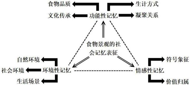
With the continuous collision of localization and globalization, the transmutation and development of local culture is constantly advancing. Ethnic and cultural borders are blurred, so that social memory is gradually lost. How to maintain the uniqueness of the destination is worth thinking about for destination marketing organizations. In this context, foodscape is deemed to establish the vivid branding image of the destination and plays a significant role in the process of creating social memory. With the rapid evolution of digital technology and mass media, the impact of videos is becoming increasingly obvious. Documentary is one of the most significant ways to save and share social memory, and its greatest feature is that it is drawn from the real living environment. A Bite of China ismore well-known compared with many other domestic and foreign food documentaries because of its strong humanistic spirituality. Thus, we use commentary and interview texts of A Bite of China as research materials. In this article, sentiment analysis, sematic network analysis, and ground theory are applied to analyze the video material, which aims to illustrate the representation and creation of foodscape on social memory. The main conclusions are summarized as follows: (1) In terms of the results of sentiment analysis, people mainly have a positive attitude toward daily food experience. The formation of social memory is based on people's self-awareness and emotional cognition. People's emotional identity forms the mainstream ideology of society and frames the development orientation of social memory. (2) According to the semantic network diagram, food taste, food culture, and family are the most significant in people's memory, which enrich the connotation of social memory. Moreover, from the perspective of time-space dimension, people can activate the path of retaining social memory and construct memorial space via ancient books, anecdotes, bodily practices, and memorial ceremonies; (3) Finally, the representation of foodscape on social memory is divided into three dimensions: environmental, functional, and emotional. First, as far as environmental memory is concerned, a specific food environment can evoke people's memory, which plays a basic role in the formation of social memory. Second, in terms of functional memory, food relies on various carriers with distinctive features, such as villages, classics, legends, customs, and folk songs, which can play social and cultural functions. Third, emotional memory emphasizes the symbolism and emotional value of food, which plays a leading role in the formation of social memory. Overall, the study reveals the mechanism of creation of foodscape on social memory. On the one hand, the research, particularly localized research, enlarges and enriches the study on food and memories. On the other hand, the role of mass media must be recognized. Additionally, destination marketing organizations ought to take active steps to create local foodscape for locals and tourists.
Based on the policy orientation of the orderly promotion of the citizenization of an agricultural population in transition, the results of studies on migrant workers' willingness to stay in the city are abundant and meaningful. Most researchers have focused on the influencing factors of their willingness to stay in the city, including personal and family characteristics, economic factors, and social factors. Less attention has been paid to the influencing mechanism from a continuous and subjective psychological perspective. To fill this gap—under the paradigm of "cognition-emotion-behavior intention," drawing on the sample survey data of Guangzhou (representing a typical immigration city in China), based on place attachment theory, and using means statistics of the sample, independent sample t test, one-way ANOVA, and structural equation model analysis methods—this paper explored the characteristics of migrant workers' willingness to stay in the city and place attachment. We focused on the empirical test of the research model concerning the influence of migrant workers' leisure involvement and local attachment on their willingness to stay in the city. The major research conclusions were as follows: (1) migrant workers' willingness to stay in Guangzhou and the degree of their local attachment are relatively strong—the mean value of local dependence is the highest (3.810), which is higher than the willingness to stay in the city (3.711), local identity (3.674), and social connection (3.400); this indicates that migrant workers pay more attention to the functional attributes of Guangzhou in work and life; and (2) there are significant differences in the willingness to stay in the city and local attachment among migrant workers with different individual characteristics, including marital status, education level, monthly income, industry, working years in Guangzhou, and home province. Demographic factors play a prominent role in migrant workers' willingness to stay in the city and local attachment: migrant workers in Guangzhou who have a high school or secondary technical school degree or above, whose monthly income is between 2 001 and 4 000 yuan, and who have worked in Guangzhou for more than one year have the strongest willingness to stay in the city. The degree of local dependence, local identity, social connections, and willingness to stay in the city is significantly lower among migrant workers from western provinces than workers from the eastern and central provinces; and (3) leisure involvement has a significant and positive direct effect on the willingness to stay in the city, while place attachment has a significant and positive intermediary effect. After the intervention of the intermediary variable of place attachment, the direct effect of leisure involvement on the willingness to stay in the city is significantly weakened, and the indirect effect is relatively and significantly enhanced. The attraction, centrality to life, and self-expression of leisure involvement have significant positive effects on the place dependence, place identity, and social connection components of place attachment and each dimension above has significant positive effects on willingness to stay in the city. The study's conclusions can provide a reference for city and community-related management departments to understand the psychological needs of migrant workers, and improve the management system of migrant workers' orderly urbanization.
Population flow is an important component of regional spatial network, but there are few empirical studies on its quantity and spatial pattern in outflow areas in extant literature. The development of the population flow pattern since 2010 has important theoretical contributions to the understanding of the population flow pattern and mechanism in modern China. Based on the Migrants Dynamic Survey of China's floating population by the National Health Commission, PRC, in 2017, this study systematically analyzed the spatial pattern and mobile network of the floating population in Sichuan-Chongqing, one of the most important outflow areas in China. The study found that the scale of the interregional outflow in this area is still large in terms of floating population. However, there has been a certain degree of population backflow since 2010 and the floating population has begun to surpass interregional mobility, which shows that Sichuan-Chongqing is increasingly attracting population. In terms of the spatial distribution pattern of floating population, the outflow to other provinces is mainly from the county units in the northeastern part of Sichuan-Chongqing and the inflow is mainly from the neighboring provinces of Sichuan-Chongqing. Further, the outflow to urban agglomerations is mainly toward the eastern coastal regions and the neighboring provinces in southwest China, whereas the inflow is toward the urban areas of Chengdu and Chongqing. Overall, the population flow here is mainly toward the urban center in both Chengdu and Chongqing. The areas that attract the utmost population flow are as follows, in order: the urban area of Chongqing; the urban area of Chengdu, which is a center for Sichuan; and the urban areas of Panzhihua and Yibin. The distribution of the population flow is highly concentrated in the central region of Sichuan-Chongqing, which shows a spatial pattern of "core-periphery." Short-distance population flow dominates the mobility network in this region. Further, the core of Chongqing urban area is closely connected with not only most districts and counties in the city but also Guang'an City and Nanchong City, Sichuan Province, whereas the core of Chengdu urban area is closely connected with the Chengdu Plain Economic Zone. Cities located along the border of Sichuan and Chongqing, such as Zigong, Yibin, Ziyang, Neijiang, and Dazhou, are greatly influenced by the cores of both Chengdu and Chongqing, and the population flow network is comparatively complex. The population flow between the two cores is weak. This shows that the administrative boundary between Chongqing and Sichuan has a significant influence on the population flow in this area.
The citizenization of the floating population is a primary task of the people-centered new urbanization. Taking the Yangtze River Delta urban agglomeration as an example, this paper analyzes the spatial distribution and influencing factors of the long-term residence intention of the urban floating population using a multilevel logistic regression method. The findings were as follows. (1) The proportion of the floating population with long-term residence intention was 38.09% in the Yangtze River Delta urban agglomeration. Cities with the highest and higher proportions of long-term residence intention were mainly concentrated in Anhui Province in the west of the urban agglomeration and the Shanghai-Nanjing development axis, while the floating population that migrated to Zhejiang Province generally had medium and low residence intention. The spatial difference of the long-term residence intention of the floating population was different from that of the floating population size. As for the types of floating population, for most cities in the coastal provinces, their floating populations were comprised mainly of inter-provincial migrants. Shanghai and Zhejiang Province, especially, were the main destinations of inter-provincial migrants. Anhui was a typical area of population outflow, and the floating population staying there was made up mainly of intra-provincial migrants. (2) The rent-to-income ratio had a significant negative effect on the long-term residence intention of the floating population. Among the personal and family factors, high education, social and psychological identity, and affordable housing were strong motivating factors, but working in the labor-intensive sector had a strong negative effect on long-term residence intention. Among the factors of the destination cities, megacities strongly influenced the long-term residence intention of the floating population. (3) The housing rent was positively related to the long-term residence intention in the Yangtze River Delta, while the average income of residents in the city did not promote the long-term residence intention of the floating population. Migrant age was negatively correlated with their long-term residence intention. These are new findings of the study. (4) The influencing factors of the long-term residence intention of the floating population varied according to the city size. Age and inter-provincial migration were the limiting factors for long-term residence intention in general cities, but they were not significant in megacities. The long-term residence intention in megacities was more related to high education and employment type. This indicates that megacities are more inclusive of inter-provincial migrants and friendly to various ages; migrants' residence intention in megacities depends more on personal qualities and employability. Besides, the average income level of the destination city only had a negative effect on the residence intention in general cities.
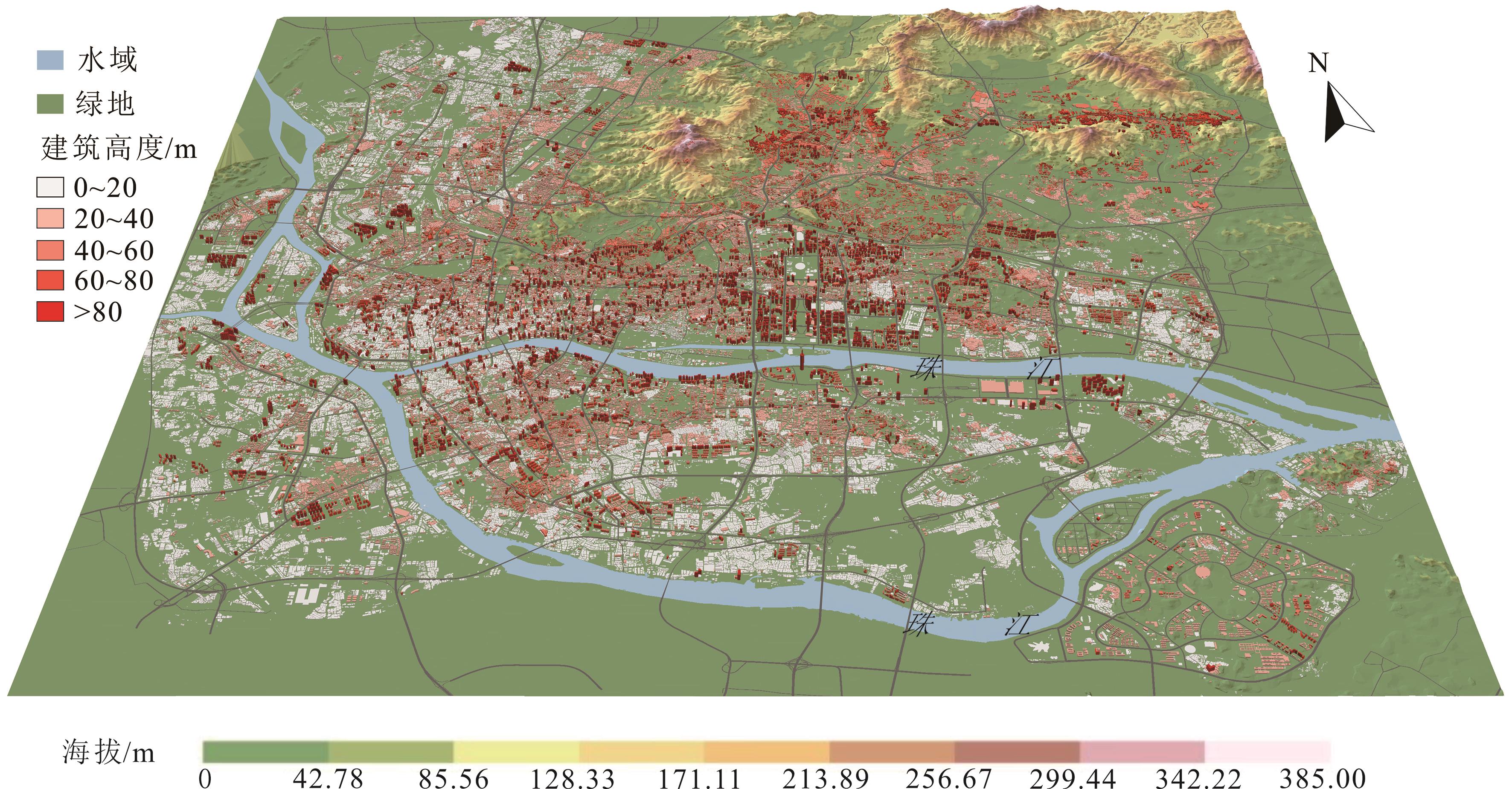
The study of urban building combinations is necessary to achieve sustainable urban development, as through such a study we can better grasp the process of urban development and evolution, guide the direction of future urban development, optimize the urban ecological environment, and improve urban livability. With the acceleration of China's urbanization process, the development and evolution of building combinations in China's urban areas are also gaining momentum. Therefore, it is of tremendous practical use to explore the laws related to mixed developments in urban areas to guide rational urban planning and the study of urban microclimates. The analysis is an important foundation for the development of urban landscapes and provides important scientific support for the optimization of the urban ecological environment and the improvement of livability levels. From the data on individual buildings in Guangzhou in 2017, this paper determined basic building combinations in the main urban area using two indexes for building height and building spacing, identified building combinations on a wider scale using a hot-spot analysis, and analyzed the spatial distribution of building combinations and the influence of macro and micro factors. Nine building combinations were identified on the basis of average height and spacing of building convergence surface. As the basic units, the nine basic types were further divided into different combinations to form complex and diverse three-dimensional representations of buildings in the main urban area. Building convergence surface with a scale of hundreds of meters constitute the basic unit of building combination in the main urban area, and are dominated by mixed land use types. The basic types, mainly composed of high-rise buildings, played an obvious role in indicating land use with differences in combinations of each functional area. The basic types of main urban areas have prominent circle differentiation, but the laws for the different types differ. Land price was the core constraining factor for the decrease in urban building height and population density from the urban center to the periphery, as well as the background factor related to differences in urban building combinations. The influence of green spaces, the Pearl River, and the main road on the type, height, and density of the building combination at a micro level complicated building combinations.
With rapid urbanization, administrative zoning adjustment has become an important means for local governments to promote urban development. The adjustment brings rapid expansion of land elements for core urban areas. Would the local government strengthen the land operation with adjusted zoning to attract investment and financing? The micro-transaction data of land transfer in the adjusted areas in the Yangtze River Delta region from 2007 to 2018 were taken as samples. The methods used include multi-stage Difference in Difference and Triple Difference models. On the basis of controlling urban economic and land parcel characteristics, this paper discusses whether the administrative division adjustment has strengthened the land operation degree in the adjusted area. The results show that: 1) compared with the areas without administrative zoning adjustment, the price of industrial land in the adjusted areas reduced by a significant 14.6%, and the transferred area of industrial land increased by a remarkable 61.5%. The transfer price of residential and commercial land increased by 13.3% and 6.9%, respectively, and their total transfer expense rose by 25%. The empirical results show that administrative zoning adjustment strengthens the operation of land transfers in the adjusted areas, and shifts more industrial land at a lower price to attract investment and commercial and residential land at a higher price for more "land finance." 2) In the first five years after the administrative zoning adjustment, land price increased significantly, but the policy effect was not substantial after five years, indicating that the strengthening of land operation had a short-term effect. 3) Because of the difficulties in regional integration, different types of administrative zoning adjustments inflate land prices to varied degrees. Compared with "consolidation of municipal districts" and "adjustment of the scope of municipal districts," "withdrawal of cities (counties) to set up districts" has a lower impact on land price. This paper aims to reveal the land transmission mechanism behind the performance of administrative zoning adjustment policy, and provide new empirical evidence for the evaluation of administrative zoning adjustment in China, starting from the role of local governments and using the micro-transaction data of land transfer.
Long-term rental apartments as a new business form in the real estate market have become more and more popular with consumers and the real estate industry due to an increase in the floating urban population and changes in people's living concepts. It is thus important to provide some guarantees in the implementation of a housing policy for "rent and purchase simultaneously." In this paper, in-depth interviews were conducted with 21 tenants who had experience in long-term apartment rental in Guangzhou. The interview data were encoded level by level using grounded theory. Finally, based on the theory of planned behavior, a model for the influencing mechanism for long-term apartment rental intention in Guangzhou was constructed. The model includes three main categories: rental attitude, subjective norms, and perceptual behavior control with six subcategories. The results show that rental intention for long-term rental apartments in Guangzhou is influenced by rental attitude, subjective norms, and perceptual behavior control. Rental attitude is composed of endogenous attitudes and exogenous attitudes. In addition to the housing demand function, risk judgment, and additional interest, the internal degree of emotional demand and brand preference also affect intention to rent. Subjective norm is composed of directive norms and demonstrative norms, while an individual's cognition of rental policy and social media guidance are important components of directive norms. Perceptual behavior control is composed of self-efficacy and facilitation, while access conditions are an important part of facilitation. The government is an important body to promote the harmonious development of the long-term apartment rental market, and needs to cultivate professional rental institutions, innovate rental modes, and establish a long-term apartment rental price supervision mechanism. The government needs to issue corresponding rules and regulations, such as provide clearer and more convenient procedures, improve the supervision system, and protect the rights and interests of tenants. The government also needs to introduce corresponding preferential policies and determine access conditions. Operators of long-term rental apartments should not only meet the functional needs of tenants, but also pay attention to their additional needs. Furthermore, they should provide a variety of social activities. Based on the needs of different groups, the operators could develop apartments for blue-collar workers, family rental apartments, and so on. Based on the theory of planned behavior, this paper explores the influencing mechanism for long-term rental intention in Guangzhou. The study enriches the research of the theory of planned behavior in the field of rental housing, and provides a reference for the government to strengthen the management of the rental market. At the same time, it is helpful for enterprises to understand the needs and expectations of tenants. The study also provides additional information for enterprise management, product design, and brand promotion.
Research on the spatial relationship of retail activities is a hot topic in urban geography. With the continuous upgrade of Internet technology, the development mode of business has evolved from the traditional retail model into the e-commerce model, and now the new retail model. While the new retail model influences the locational decision-making behavior of enterprises, it also affects the intrinsic mechanism of attraction and avoidance among retail stores, which in turn affects the spatial association relationship of commercial retail. In such a context, we take the Starbucks, COSTA, and Luckin Coffee stores in Shanghai's inner ring as our research objects, and use a variety of spatial statistical methods and field research to analyze the spatial correlation characteristics among the three. The results show that, first, the spatial distribution of coffee stores under both traditional and new retail models generally exhibit the spatially oriented characteristics of being close to the consumer market. Therefore, it can be indirectly inferred that although Luckin Coffee, which is characterized by new retail, can create "infinite space" to meet consumers' consumption needs in different spaces by virtue of its own Internet development advantage, it remains difficult to completely break away from the spatial orientation of the offline consumption market. Second, in terms of spatial agglomeration, Starbucks' high sensitivity to specific consumer groups and its sales strategy of providing a comfortable environment have led the business to open stores in dense proximity in locations with high consumption potential, thus contributing to its strongest spatial agglomeration. Luckin Coffee, by contrast, has a certain degree of flexibility in choosing store locations due to its independent instant delivery service, and in order to occupy a wider market as soon as possible, it chooses store locations in favor of uniform coverage, resulting in the weakest degree of spatial agglomeration. Third, based on multivariate spatial statistics, it can be seen that Starbucks, COSTA, and Luckin coffee stores all exhibit positive spatial relationship characteristics in the two corresponding spatial relationships. Among them, traditional coffee retailers Starbucks and COSTA show a more obvious spatial relationship of mutual attraction, indicating that both can increase their market shares by converting the fierce price competition between them into an attraction drive to increase their total profits. At the same time, the stores of traditional retailer Starbucks and new retailer Luckin Coffee also show a significant spatial relationship of mutual attraction in space, indicating that the market share effect dominates. Finally, micro-location analysis reveals that Starbucks and COSTA stores have a stronger mutual attraction relationship and often appear in pairs in the center of shopping districts or business areas, while Luckin Coffee stores are often located in "non-central" areas. As a representative of new retail, Luckin Coffee can make up for its location disadvantage to a certain extent by virtue of its mobile application online service and instant delivery service. The store can also utilize its Internet platform, big data analysis, and other technical advantages, so that it can combine its own product positioning characteristics when choosing store locations, and accurately find potential store locations and opening models. Therefore, when carrying out urban planning, especially the planning of commercial areas, attention should be paid to the impact of the new retail model on location selection, the role of the Internet, and big data in location decision making. The development possibilities of traditionally weaker locations should be explored, and the efficiency of urban land use should be improved.
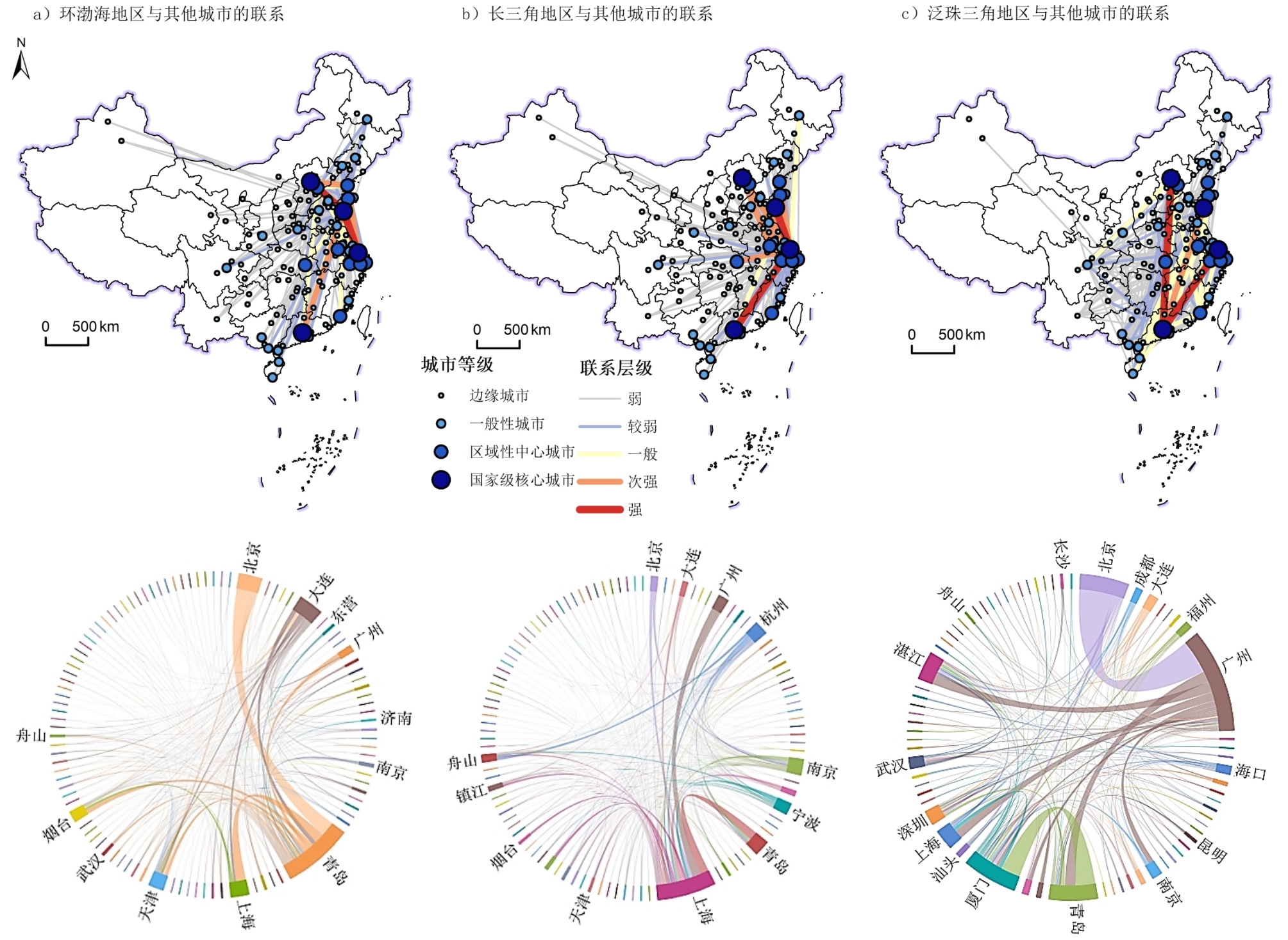
Marine science and technology are the means to develop healthy maritime productivity. In recent years, the marine economy arrived at the point of developing from high speed to high quality. China is paying more attention to how to use the sea scientifically. The development of marine science research has received more policy support. The outline of the 14th Five-Year Plan proposes to "make breakthroughs in a number of key core technologies in the fields of marine engineering, marine resources, and marine ecology." At the same time, urban network theory based on flow space is a mature and convenient way to measure inter-city scientific research cooperation. An analysis of the structure of this network will help clarify its structural characteristics and spatial differentiation, discover the technical opportunities of marine scientific research, and promote the coordinated development of academic research and the applied technology fields. With the help of the complex network analysis method, UCINET, ArcGIS, and string chart visualization software, this paper analyzes the overall structural characteristics and spatial differences of the marine research cooperation network in 2007 and 2017, respectively, to provide empirical support and a theoretical reference for the development and construction of the network. The results show that first, the marine scientific research cooperation network has obvious characteristics of a "small world" and "scale-free" network, with strong accessibility and agglomeration, and an improved openness; at the same time, it presents discrete trends and unbalanced characteristics. Second, different from the "diamond" structure of the information and innovation cooperation network, the marine scientific research cooperation network in China has formed a special "trapezoidal" structure with Beijing-Tsingtao—Shanghai-Guangzhou as the apex; the focal cooperation ties in the network have increased and gradually broadened. At the same time, three marine scientific research cooperation clusters with different functions, characteristics, and research fields have been formed in the Bohai Rim, the Yangtze River Delta, and the Pan-Pearl River Delta. Finally, the leading pattern of core cities has been consolidated, among which Qingdao plays a strong role as a "throat" and is a national marine scientific research center with a strong ability to control marine scientific resources. Some of the core nodes (such as Beijing and Wuhan) are inland, but they have a strong independent capability in marine scientific research, and an enthusiasm for engaging in scientific research cooperation; in other words, marine scientific research cooperation is characterized by significant complexity. Formation based on marine research papers in the network embodies the link between the cities. On the one hand, this reflects the influence of the research subject emphasis of the cooperation network, such as a core city taking a leading role, or being the backbone of key research institutes, etc.; on the other hand, it also reflects the network between cities that cooperate in research and the contacts that result. Exploring the marine scientific research cooperation network through marine scientific research institutions will have a positive impact on the reconstruction and network progress of national and regional marine scientific research cooperation.
With the ongoing global climate change, extreme heat events have a profound negative impact on the socio-economic development of cities. In this study, through a portrayal of the urban vulnerability pattern of cities under extreme heat stress in China, as well as an in-depth analysis of its influencing factors, a foundation was laid targeting reduction in the risk of extreme heat event occurrence in these cities and building a healthy urban environment. Herein, the municipal districts of 280 cities in China were considered as the research targets. On the basis of meteorological observation data, census data, and socio-economic statistics, the urban vulnerability assessment index system for extreme heat was constructed from the standpoint of three dimensions: Exposure, sensitivity, and adaptability. The set pair analysis method and the vulnerability index model method were used to comprehensively calculate the indices of urban exposure, sensitivity, adaptability, and vulnerability to extreme heat. Thereby, the spatial and temporal distribution patterns of urban exposure, sensitivity, adaptability, and vulnerability to extreme heat in the main cities in China for 1990, 2000, and 2010 were revealed, following which the factors affecting the urban vulnerability to extreme heat were discussed. The following conclusions from three standpoints were ultimately drawn. First, from 1990 to 2010, the urban exposure index to extreme heat in China gradually increased, the urban sensitivity index first rose and then declined, and the adaptability index demonstrated a slow decline. The overall spatial distribution of urban exposure to extreme heat is high in the south and low in the north, while the urban sensitivity and adaptability to extreme heat are widely distributed and scattered throughout the country. Second, from 1990 to 2010, the number of cities with a high vulnerability to extreme heat showed an overall trend of increase, accounting for 24%, 28%, and finally 62% of highly vulnerable cities, which implies that the vulnerability to extreme heat in China gradually increased. From 1990 to 2000, the pattern of urban vulnerability to extreme heat in China changed slightly. In 2010, the number of cities with high vulnerability increased sharply, and the distribution range expanded from the south to the north of China. Further, the overall distribution of urban vulnerability to extreme heat was high in the south and low in the north. Third, urban vulnerability to extreme heat is mainly affected by the regional climate conditions, natural environment, and differences in urban development levels. The average monthly temperature in summer and heat island intensity both have a significant positive impact on the urban vulnerability to extreme heat. On the contrary, the per capita local fiscal revenue, average precipitation in summer, output value of the secondary industry as a percentage of GDP, elevation, maximum wind speed, and per capita investment in fixed assets all have a significant negative impact on the urban vulnerability to extreme heat. However, the positive impact of the average monthly temperature in summer on urban vulnerability to extreme heat is far greater than the negative impact of social and economic conditions. Therefore, it can be inferred that urban vulnerability to extreme heat is mainly affected by the regional temperature environment.
The Global, Self-consistent, Hierarchical, High-resolution Geography (GSHHG) Database, provided by the National Centers for Environmental Information and widely used worldwide, includes global multi-scale coastline data. Although many scientists have utilized this database in their studies, the database itself has not been thoroughly evaluated. The different scales available through the GSHHG database include full resolution, high resolution, intermediate resolution, low resolution, and crude resolution. The Pearl River estuary was selected as our study site. These studies involve the use of the GSHHG database, Landsat MSS from 1978, and Landsat OLI from 2018 to evaluate the differences in coastline length and fractal dimensions among GSHHG datasets collected at five different resolution levels. This study also selected eastern and western sub-regions to compare differences between coastline maps from the GSHHG and Landsat datasets. In addition, the coastline extracted from resampled Landsat OLI data from 2018 (80 m), covering the eastern part of the Pearl River Estuary was compared with the same coastline data extracted from Landsat OLI at 30 m spatial resolution. Coastline lengths according to full resolution, high resolution, intermediate resolution, low resolution, and crude resolution data are 1509.47 km, 1398.12 km, 1212.54 km, 692.00 km, and 326.40 km, respectively. The corresponding fractal dimensions from the GSHHG database were 1.2983, 1.2832, 1.2588, 1.0990, and 1.0262 for full resolution, high resolution, intermediate resolution, low resolution, and crude resolution, respectively. Separate eastern and western segments of the Pearl River Estuary demonstrate that for a given area, full resolution of GSHHG data provides the longest and most detailed rich coastline data relative to the coastline data extracted from the Landsat data and GSHHG database. The length of the coastline extracted from the 1978 Landsat MSS was most similar to the length obtained from high-resolution GSHHG. The data on the morphology of the coastline in the 1978 Landsat MSS were much closer to the full resolution, high resolution, and intermediate resolution data obtained from GSHHG. Compared to the coastline data extracted from 80 m Landsat OLI and 30 m Landsat OLI, a 17.68% length difference was found. Fractal dimension differences were 1.7%. The results show that: (1) The length and fractal dimensions of coastline data produced at five different resolutions are substantially different. Higher-resolution data produce longer coastline lengths and more complex coastline morphologies; (2) Using coastline data extracted from Landsat data in 1978 and 2018 as references, GSHHG coastline dataset was found to be generally consistent with real data shoreline length and morphological characteristics. The morphological characteristics of the GSHHG coastline are closer to the real data from 1978, which does not reflect the current situation of the Pearl River Estuary. The GSHHG database only includes one phase of data, implying that scientists cannot accomplish studies related to coastline change without using additional data. Nevertheless, studies on comparisons between different regions of coastline could select data based on the characteristics of a study area. It is suggested that scientists select coastline data based on coastline length, complexity, and morphology when studying coastline changes in response to situations of interest.
Guangdong Province has the largest extent of coastal aquaculture in China. Quantitative analysis of the spatial distribution pattern and evolution trend of on-land artificial aquaculture bases in the coastal areas of Guangdong Province has great significance for exploring the sustainable development approach of freshwater aquaculture in the region. Based on the Google Earth Engine cloud computing platform, Sentinel-1 SAR imagery, and other data, this study extracted the artificial aquaculture bases of the 14 coastal cities in Guangdong Province from 2015 to 2019 using an object-oriented method, implemented quantitative analysis on its spatial distribution trend and high-density distribution area, and analyzed the relationship between these aquaculture bases and city economic growth. The classification results of the regular artificial aquaculture bases in this study showed that the extraction of aquaculture bases based on radar remote sensing imagery had high accuracy, with an overall accuracy of 90.5% and a kappa coefficient of 0.81. The results also showed that the total area of artificially regulated aquaculture bases in Guangdong Province had an upward trend from 2015 to 2019, with a net increase of 163.1 km2. The three cities with the largest net area growth were Jiangmen, Zhongshan, and Guangzhou. Using a grid with 1 km resolution to study the density dynamics, the density of aquaculture land in most areas was found to have increased, especially in high-density areas. Among these, 80% of the artificial aquaculture bases were concentrated within 5 km of the coastline, and the bays and river inlets had the highest densities and largest areas of aquaculture land. A comparison of the distribution patterns among different cities showed that the cities with the most concentrated aquaculture land within the land boundary were Shantou, Chaozhou, Zhuhai, Zhongshan, Shenzhen, Zhanjiang, and Yangjiang, followed by Shanwei, Guangzhou, Jieyang, and Jiangmen, and that Maoming, Dongguan, and Huizhou were the least concentrated. In terms of economy, the proportion of aquaculture industry in the regional GDP declined in more than half of the cities, increased in only Yangjiang, and remained unchanged in the others. In addition to the fact that Guangdong Province's economic development focuses on secondary and tertiary industries, this result may also be related to the government's ongoing ecological restoration actions, which have restricted aquaculture land use. In general, aquaculture land in the coastal cities in Guangdong Province showed an overall trend of expansion. Moreover, the growth in area of regular aquaculture bases showed a significant correlation with the value of aquaculture production, further indicating that land expansion of artificial aquaculture bases continued to be the main method for increasing the value of aquaculture production in Guangdong Province. Such an expansion trend poses a great challenge to the distribution and sustainable use of wetlands, cropland, and urban land in the coastal zone.
The relative abundance of stable isotopes in precipitation plays a vital role in the water cycle analyses and diagnosing atmospheric circulation patterns. The analysis of stable isotopes in precipitation in a short time scale is beneficial in the study of controlling factors of stable isotopes in precipitation with increasing time resolution, in the acquisition of detailed information of stable isotope fractionation during phase transition, and in understanding the fractionation mechanism. As such, the characteristics of diurnal and night precipitation were analyzed and compared under different seasons (warm half-year and cold half-year), different precipitation types (convective precipitation and large-scale precipitation), and different precipitation intensities based on the observation data on stable isotopic composition (2H and 18O) in precipitation within Changsha. We aimed to determine the differences of stable isotopes in precipitation between day and night and their influencing factors or enhance the understanding of the regularity of stable isotopes in precipitation within the monsoon region. Results showed that δ18O in precipitation was more enriched during the night than in the day during the warm half-year; the opposite occurred during the cold half-year and negatively correlated with precipitation intensity. Whether in the warm or cold half-year, the d-excess in precipitation is more positive in the night than in the daytime because of the low temperature and high relative humidity at night, as well as the weak evaporation and enrichment of heavy isotopes, while the LMWL slope was higher during the day than during the night. Under convective precipitation, water vapor with relatively rich isotopes in the lower layer is lifted in strong updraughts, and compared to the convective precipitation, δ18O in precipitation is positive. Furthermore, the weak vertical motion of the air in the stratiform clouds make the water vapor with relatively depleted isotopes converge in the upper layer, and the δ18O in the precipitation is more negative; the LMWL slope of the former is lower than that of the latter. The slope and intercept of LMWL increased with precipitation intensity, while the stable isotopes in precipitation decreased with the increase in precipitation intensity. When the precipitation intensity was greater than or equal to 0.1 mm/12 h, the LMWL slope was higher during the day, and the intercept was higher during warm half-year night and cold half-year day. When the precipitation intensity was greater than or equal to 5.0 mm/12 h, the slope and intercept of the LMWL were higher at warm half-year days and cold half-year nights.
Eliminating poverty and exploiting natural resources are sustainable development goals for modern society, especially for developing countries or regions. To achieve these targets, development-oriented eco-tourism planning and design can empower rural areas with rich available natural resources to eventually achieve the aforementioned goals. Pro-Poor Tourism (PPT), an initiative proposed by the UK's Department for International Development in 1999, is regarded as an effective pathway that benefits, through tourism, the underprivileged population living in poor areas. For the purpose of attracting the participation and increasing the income of the poor population, we conducted research, in the present study, on possible models of development-oriented poverty reduction via ecotourism in forest zones. We then proposed several development paths for PPT industries in Lechang city, Guangdong province, southern China, by utilizing the literature review method and conceptual analyses and comprehensively adopting the PPT strategy. The results indicated that: 1) four stakeholders [(i.e., government departments, tourism enterprises, rural communities, and non-profit social organizations (NGOs)] are responsible for engaging the poor population, alleviating poverty, and protecting the environment in different ways. Specifically, government departments are expected to play a leading role in setting up platforms and supervising the situation, tourism can maximize its usage of various ecological resources rationally and sustainably, and the rural communities and NGOs are recommended to serve as an organic unit, working together to push forward certain PPT tasks and form practical development models. 2) In consideration of the availability of three featured types of ecological resources (i.e., natural forests, high mountain tea, and characteristic vegetables and fruits) in Lechang city, the present study put forward a compound development model of ecological tourism consisting of the above three featured agro-forestry resources.Furthermore, we proposed three possible pathways suitable for the industrial development of Lechang city; that is, (i) "leisure agriculture + characteristic forest fruit industry + e-commercial tourism industry," (ii) "understory leisure industry + understory economic industry + initial processing of forest products," and (iii) "forest eco-tourism + characteristic forest planting + natural ecological education." In conclusion, our study suggests that the rational utilization of the PPT strategy and the effective integration of government departments, tourism enterprises, rural communities, and NGOs could facilitate subsequent tasks. The study also emphasized that achieving the anticipated three goals (i.e., comprehensive development of economy, comprehensive development of poor communities, as well as poor population and ecological sustainability) might largely rely on the full consideration of benefits for the economy, society, and the environment during the process of development-oriented poverty reduction via eco-tourism by the four stakeholders.