The relationship between the geographical environment and international politics is the main concern in geopolitical research. The existing publications were either inclined to environmental determinism, focused on the geographical imagination constructed by subjective discourse, or investigated the elements in the geographical environment as a whole to explore their interaction with politics. Evidently, discussion is lacking on how geo-entities use the spatial (structure) differentiation of geographical environments to act on power space and their geo-setting effects. Combining theoretical construction and case analysis, this study demonstrates the medium properties of geographical environment and its difference in efficiency of transmission power by proposing the concept of "geographical medium," and clarifies the geopolitical functions of different geographical mediums. Taking Ukraine as a case, the spatial practice of geo-entities mining is revealed herein; furthermore, the role of medium properties of the geographical environment in the enactment of power and their geo-setting effects are demonstrated. The results show that: (1) located in the geostrategic intersection zone, the geographical environment of Ukraine has a significant medium property, which provides a spatial intermediary for actors to establish power in Ukraine; (2) the geopolitical functions of various medium elements in Ukraine's geographical environment and their power transmission effectiveness to actors are significantly different. Geographical position and topography are geo-security functions. Natural resources have powerful geo-economic functions. Political parties and nationalities have strong geopolitical functions, while languages and religions have more prominent geocultural functions. The media attributes of natural resources, political parties, nationalities, and religions are strong; by contrast, the media attributes of geographical location and topography are gradually weakening; (3) different geo-entities (interest groups) compete to use the medium properties of the geographical environment to enact power, so that their geo-potential in Ukraine has alternating growth and decline, which intensifies turbulence in Ukraine's geo-setting. Finally, exploring the spatial practice and its effects of power exertion from the perspective of geographical media has enlightening significance for enhancing China's geopolitical influence abroad.
Although political geography has been gaining popularity in China as a sub-discipline of human geography, its methodological development has been limited to the quantitative paradigm. As a widely used research method in social sciences, discourse analysis remains under-used in Chinese geo-environment analyses. This study discusses the application status and prospects of discourse analysis methods in geo-environment analysis within the Chinese scholarship. First, this study discriminates the concepts, theories, and analysis paths involved in discourse analysis methodology. Specifically, it discusses how discourse is conceptualized compared to text, language, discourse formation, discourse structure, textual analysis, and content analysis. Subsequently, the study discusses various case studies of discourse analysis in human geography, which focuses on the application of the discourse analysis method in geo-environment analyses. Additionally, the study introduces other commonly used research methods in geo-environment analyses, to deepen readers' awareness of the characteristics of discourse analysis. Further, it discusses other possibilities of discourse analysis in future geo-environment analyses. By doing so, this study highlights the status and importance of discourse analysis within Chinese political geography. On this basis, this study uses an empirical case study from the Journal of Contemporary China to discuss global perceptions of China's rise, thus providing an accurate practical guide to explain how discourse analysis should be expanded in empirical case studies. Then, this study addresses the challenges and potential of discourse analysis in the background of an emerging Big Data era. Finally, the study combines the current background of continuous innovation in geographical research methods with discourse analysis. Accordingly, it discusses the possible future role of discourse analysis as a relatively traditional research method in geopolitics, or more generally, within human geography.
The Arctic has an important strategic position owing to its rich resources. The world's major nations want to enter the Arctic to participate in Arctic affairs and establish influence in the Arctic; it has become one of the current international hot spots. The current research on geo-setting has turned to the perspective of the national state, but there is little research on this region. Under the background of global warming, China proposed the Arctic policy to build the "Polar Silk Road" with all parties as responsible nations. Based on the framework of geo-setting, this study analyzes the geo-setting of the Arctic and the influence of the "Polar Silk Road" on the geo-setting of the Arctic. First, the geo-setting of the Arctic is complex because it is located at the northernmost end of the earth. It contains rich resources and possesses high strategic value, which has led to competition among major nations in the world. As such, the geo-relations in the Arctic involve many subjects and issues. The subject relations include three aspects: the relation among Arctic nations, the relation between the Near-Arctic nations and the Arctic nations, and the relationship between Arctic aborigines and Arctic nations. These issues focus on territory, economy, energy, and the benefits of Arctic aborigines. The geo-structure of the Arctic has experienced three stages of evolution, and now presents a complex structure with the characteristics of "Central-Subcenter-Periphery." Second, the "Polar Silk Road" will influence the geo-settings in the Arctic in two aspects: on the one hand, although some nations disagree with the "Polar Silk Road," it will improve the tense geo-relations in the Arctic, promote the sub-regional cooperation, enable the participation of the Near-Arctic nations in Arctic affairs, and protect the Arctic indigenous people in general. On the other hand, it will make the core of the geo-structure more stable, the tightness among geo-entities closer, and further extend the geo-relations network.
Iran is an important political power and strategic hub in the Middle East, connecting Central Asia and West Asia, acting as a significant route from Asia to North Africa and Europe; it is an intersection of the "Silk Road Economic Belt" and the "21st Century Maritime Silk Road". Coupled with the enrichment of petroleum resources and the control of global oil security, Iran's geostrategic position is very important. This study constructs a geo-potential mathematical model and index system from a spatial perspective, including the geo-weight evaluation index system, weight distribution, interdependence index, and geo-distance measurements while innovatively incorporating the element of geostrategic investment willingness. Based on these factors, this study conducts a quantitative, comparative analysis of the geo-potential of China, the USA, and Russia in Iran after September 11st, 2001, from two dimensions—"strong-weak" and "positive-negative." Subsequently, the driving factors and mechanisms of geo-potential are obtained through mathematical model construction and empirical research. Finally, by placing Iran on regional and global scales and thoroughly considering both international and regional geopolitical patterns around foreign policy and strategy, we analyze geopolitical relations between China, the USA, Russia, and Iran: diplomatic, economic, and cultural factors considered from a geo-potential perspective. We hope that this study will enrich research on Iran studies and geopolitical studies, through its understanding of the power interaction mechanism and geopolitical relations between global powers and Iran, while providing a research basis to promote the high-quality development of the Belt and Road Initiative. The following conclusions were drawn: (1) The USA's geo-potential in Iran fluctuates frequently in the negative high range, and Russia's geo-potential fluctuates slightly in the positive median range. Fluctuations between these two countries thus show a "strong - strong" interaction. The change of China's geo-potential is relatively separate from that of the USA and Russia, showing an "S" shaped curve trending upward, thus gradually narrowing the gap with Russia. Russia and China have a positive influence on Iran (attraction), while the USA has a negative influence on Iran (repulsion), which is much stronger than the attraction from Russia and China. (2) Geo-diplomacy is the decisive factor guiding the trend of geo-economy and geo-culture. Geo-economy is the direct driving force of the evolution of geo-potential. Geo-culture acts as a collaborative factor; geo-economy and geo-culture both have a potential influence on geo-diplomacy. (3) Based on amicable geo-cultural relations, the strengthening of China's comprehensive national strength and the deepening of bilateral economic interdependence constantly enhances the intensity of geopolitical relations between China and Iran. The geopolitical relationship between the USA and Iran is occasionally eased but is generally poor. Volatility is largely due to changes in foreign policy triggered by the change of governments, which is the dual response of the domestic political system and the international political environment. The close geopolitical relationship between Russia and Iran is owing to the geographical proximity and the need for a geo-strategy. There is a stable but complex geopolitical relationship network between these two countries, composed of economic, political, and security factors.
Emotional geopolitics, as a new field of geopolitical research, advocates that geopolitics should pay more attention to the analysis of emotion. It breaks the dualistic opposition between emotion and reason in classical geopolitical theory, and places emotion at the center of geopolitical analysis. Through the application of non-representational theory, emotional geopolitics takes individual emotion from the periphery to the core. At present, studies on emotional geopolitics in the West have focused on the power geometric relationship of "everyday life-emotion-global politics" from both the macro and micro views. The macroscopic approach constructs the structural relations between different emotions and political actions, attempting to develop general theories on how emotions matter in geopolitics, whereas micro studies focus on how specific emotions gain resonance in particular political circumstances. Microscopic approaches investigate how specific emotions are constituted by and function in particular cultural and political environments, and how emotions in different cultural contexts are localized and serve to interact with global geopolitics. By searching "emotional geopolitics" and "affective geopolitics" as key words in the Web of Science, 145 articles were detected, and 73 of these were reviewed in this study. The number of articles related to emotional geopolitics fluctuated before 2018 and has increased significantly in recent years. The study subjects of this emerging field include youth, housewives, diplomats, and border migrants. The research topics are diverse, mainly including critical geopolitics on global fear, daily life and emotional geopolitical practices, and the relationship between emotion and policy/diplomatic action. First, the emergence of globalized fear associated with terrorism and the War on Terror since 2001 played an important role in shaping the Western geopolitical environment in the past decades. Some scholars tend to criticize the discursive strategies and specific actions of fear geopolitics by arguing that governments and public policies increasingly exploit and recreate the emotion of fear to control and manipulate state decision-making and community actions. Second, emotional geopolitics inspired by feminism, popular geopolitics, and anthropology theoretical approaches, focus on exploring the emotional lives of individuals with the intervention of geopolitical action. Most emotional geopolitics literature draws on the everyday lives of ordinary people, not only focusing on the affective intervention of geopolitics in individuals' daily lives, but also continuously exploring how people emotionally respond to geopolitical events and how these emotions are related to collective action in different contexts. Third, some studies have examined the roles emotions play in policy/diplomacy. As a force of public opinion, emotions provide legitimacy or impetus to geopolitical action. This paper argues that the study of emotional geopolitics can provide a new perspective on the changes in the world system and geopolitical relations caused by the rise of China, enriching the understanding of subjectivity and multi-scale of geopolitics in theory.
As the melting of Arctic Sea ice because of global warming creates new shipping routes and energy resources, the post-Cold War peace and stability of the Arctic has been shattered. It has once again become a strategic location for multinational rivalries, attracting widespread attention in international geopolitical circles. Compared to other regions of the world, studying the Arctic region from a Western geopolitical perspective is at the forefront of international research. Although China, as a near-Arctic country, has developed geopolitical research on the Arctic in response to its practical needs, domestic research in this field started late, with room for improvement in its breadth and depth. Therefore, 98 papers in the Web of Science core database that are highly relevant to Arctic geopolitics are selected as the object of the study. Through a literature review, we summarize the development of Arctic research from a Western geopolitical perspective, and the shift in perspective and hot topics; we adopt a forward-looking perspective of future research development trends to provide reference for innovative research in this field in China. The results reveal the following: (1) Research on the geopolitics of the Arctic has been conducted in a wide range of fields and topics in Western academia, with some correlation among the topics, although the links among the studies are not strong, and the research scale generally shows a fluctuating growth trend. (2) The research content, composed of six major fields (boundary and territorial politics, Arctic shipping routes, Arctic resource development, Arctic geo-strategy, Arctic security and governance, and indigenous population issues), focus on politics and economics but is lack of cultural research. (3) Under the influence of aesthetic humanism and the "cultural and institutional turn," the trend in the cross-fertilization of geopolitical, geo-economic, and geo-cultural perspectives has increasingly become more obvious. (4) Research on the Arctic from a geopolitical perspective has been relatively fruitful, although there remain shortcomings in the depth of theoretical research, breadth of research scale, diversity of research methods, and geo-economic and geo-cultural research paradigms, which require further development. Future research will generate new ideas and directions in immaterial areas such as theoretical framework studies, interdisciplinary studies, and emotional culture, and will focus more on the role of multiple actors, such as indigenous peoples and NGOs, in geopolitical knowledge production and power competition.
Aquatic products trade is an important part of the marine economy, and a key measure to ensure the effective supply of aquatic products and maintain the fishery industry chain. Optimizing the aquatic products trade network is greatly significant in guaranteeing China's food security and expanding international trade. With the help of the United Nations Commodity Trade Database, in this study, we select the aquatic products trade data of countries along the "21st Century Maritime Silk Road" from 2000 to 2019, measure the structural characteristics of the aquatic products trade network using the social network analysis method, and analyze the aquatic products trade market structure and product structure of countries located along the line. The results show the following. First, the changes in the aquatic products trade of countries along the "21st Century Maritime Silk Road" from 2000 to 2019 can be divided into two stages: the steady growth period from 2000 to 2008, and the fluctuating development period from 2009 to 2019. Second, the density of the aquatic products trade network is gradually increasing, spatial agglomeration and network cohesion are being gradually enhanced, and the accessibility of the network is continuously improving, which shows the characteristics of small cosmopolitan. Third, the core-periphery structure of the aquatic products trade network is stable, and the trade of the core countries is closely linked, accounting for more than half of the total trade volume. Geographical location and distance indirectly affect the group. The division of community shows the characteristics of hierarchy and geographical proximity. There are significant differences between multilateral and bilateral trade flows, and the heterogeneity of trade cyberspace is obvious. Fourth, the spatial differentiation characteristics of the aquatic products trade network are relatively obvious. The important node countries are mainly concentrated in China and Southeast Asia. Countries with high betweenness centrality and countries with high closeness centrality have convergence, and the network centrality influence of East Africa and the Red Sea coastal countries is weak. Fifth, China occupies a large share of the aquatic products market structure of the core countries. The change in the relationship among countries causes adjustments in the market structure. The import and export structure of aquatic products in China is relatively single. The imports consist mainly of frozen fish, while the exports consist mainly of processed aquatic products.
As an extension of the Belt and Road Initiative to the Arctic, the Polar Silk Road initiative has provided opportunities for international trade development along its routes. this can accelerate the transnational flow of economic factors and promote the sustainable development of global trade. Based on the trade data of 37 countries along the Polar Silk Road in 2019, a trade network of these countries has been constructed. The complex network analysis method is used to study the topological structure characteristics of the trade network and to analyze the geo-spatial distribution characteristics of the three centrality indexes of the nodes. Community detection is used to identify the structure of the trade community and analyze its spatial distribution characteristics. With the help of the Continuous Coreness model, the core degree of the country is calculated and its circle structure is visualized. This study found that: (1) The high density and reciprocity of the trade network indicate that the network is very interoperable and diffusive. Compared with the random network, the Polar Silk Road trade network has a higher agglomeration coefficient and a shorter average path length, indicating that it has the characteristics of small-world and scale-free. (2) The trade network node has a typical hierarchy, presenting obvious characteristics of the "core-edge" circle structure, while Germany, China, the United States, and the Netherlands are in the core circle and are the hubs of the trade network. (3) The trade network can be divided into five different communities, namely the North American community, a community dominated by East Asian countries, and three communities dominated by European countries. Their spatial distribution is characterized by continuity, with close trade links among the communities, and China is the core of the community to which it belongs. (4) The trade network is characterized by the coexistence structure of hub radiation and full connection. The intensity centrality presents an embedded unit pattern, and the closeness centrality is characterized by the block distribution of a concentrated continuous area. The polarization of intermediary centrality is very obvious, forming a spatial pattern of "high in European and American countries and low in Asian countries." This study enriches the empirical research on the trade network of countries along the Polar Silk Road, provides new ideas for promoting trade cooperation and development of countries along the road, and is conducive to optimizing the trade network structure. It also provides a theoretical basis for China to rationally formulate the economic construction strategy of the road and the ways and specific implementation of trade cooperation with countries on that route. Future research could focus on the evolution and influencing factors of the trade network topology characteristics of countries along the road, with a view to better explore ways to promote the implementation of the Polar Silk Road initiative.
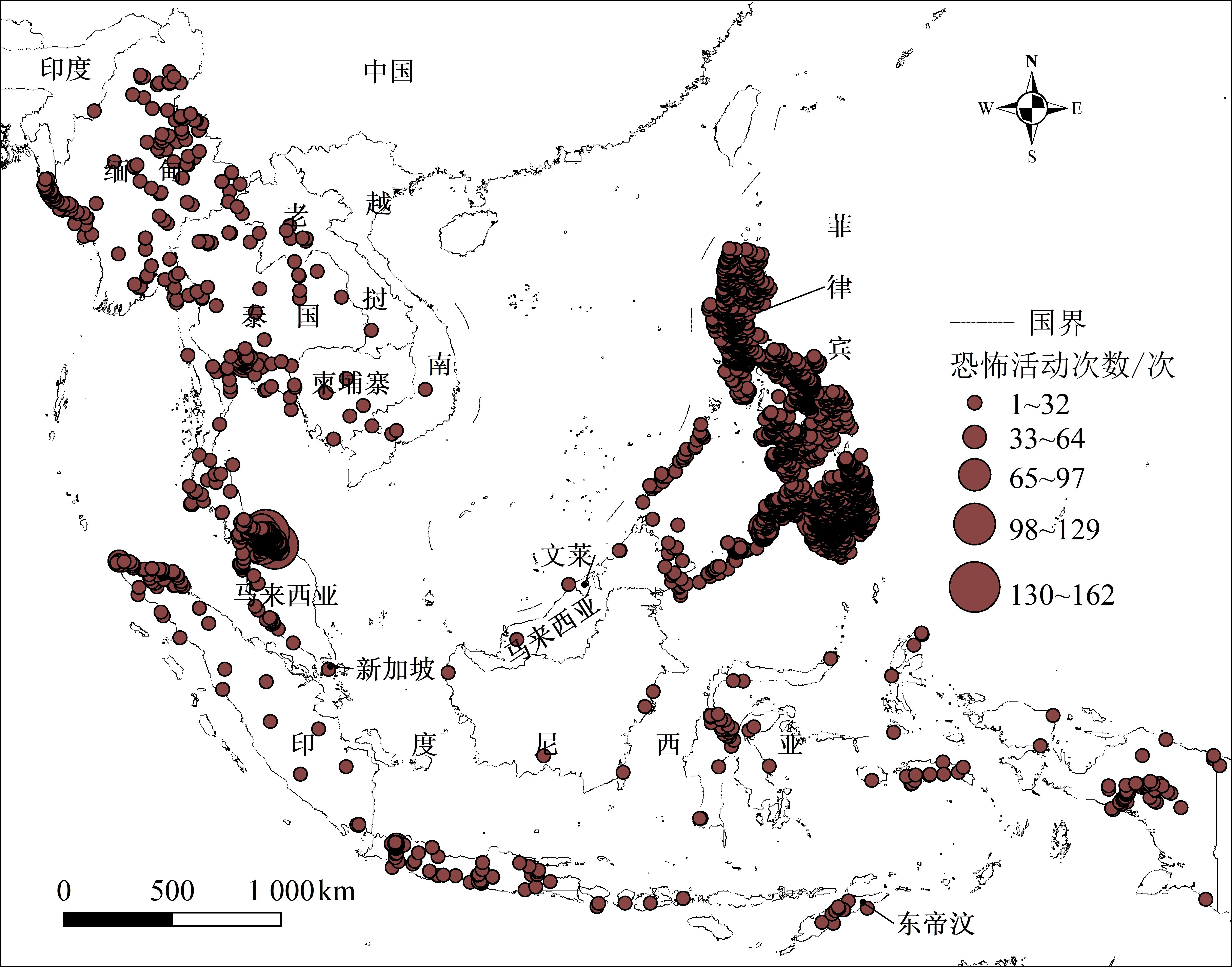
Since 2000, terrorism in Southeast Asia has developed rapidly via numerous terrorist organizations. As the regional anti-terrorism situation has become increasingly severe, regional security has faced serious challenges. The research is based on the research data of the Global Terrorism Database (GTD), using geospatial statistical methods to visualize the spatial variation terrorist activities in Southeast Asia from 2000 to 2018, and to analyze the characteristics of the temporal and spatial research of terrorist activities in Southeast Asia. Social network analysis methods were used to analyze the internal and external social relations of terrorist organizations in Southeast Asia. This helped us to have a certain understanding of the development situation of terrorism in Southeast Asia and to provide a reference for Southeast Asian countries to formulate relevant counter-terrorism measures and strengthen regional counter-terrorism cooperation in the future. The study draws the following conclusions: (1) A total of 10,440 terrorist activities occurred in Southeast Asia from 2000 to 2018, showing a significant volatility growth over time, with obvious phase changes. According to the trend of terrorism in Southeast Asia and its spatial changes, this period can be divided into three stages, namely: rising volatility (2000-2010), rapid development (2011-2013), and turbulence and change stage (2014-2018). In terms of spatial distribution, Southeast Asian terrorism activities are highly concentrated, with significant agglomeration, showing a trend of diffusion and agglomeration. The agglomeration center has changed from a two-pole agglomeration center in 2000 to a three-level agglomeration center in 2018: the southern region of Thailand, the southern islands of the Philippines and the southern islands of the Philippines, and mountainous areas in western Myanmar. (2) There are many terrorist organizations in Southeast Asia, the types of which are complex. The members of the terrorist organization network are closely related. The terrorist organizations and the lone wolf type terrorism are related through intelligence, resource, and personnel exchanges. A huge cross-regional terrorist organization network has been established. In this network of terrorist organization relations, various terrorist organizations cooperate and act together, posing a serious threat to the anti-terrorism situation in Southeast Asia. In the 1990s, Southeast Asian terrorist organizations represented by JI, established the 4M activity network with a clear division of labor across many countries with the support of foreign organizations and used this activity network to raise funds, train personnel, and plan activities. (3) There are deep-seated reasons for the rapid rise of terrorism in Southeast Asia, not only the influence of social culture, political environment, and economic development within the region but also the intervention of terrorist forces outside the region.
The inherent geo-strategic attributes of the "Belt and Road" initiative are inevitably impacted by geo-risks. Latin America is a critical practice space for the "Belt and Road" initiative. As a natural extension of the 21st Century Maritime Silk Road, it plays a pivotal role in the "Belt and Road" initiative. However, there is a lack of systematic research on the geo-risks faced by the "Belt and Road" initiative in Latin America. The study aims to measure the geo-risk index faced by the 33 sovereign countries of the "Belt and Road" initiative in Latin America and its spatial differentiation pattern; further, it aims to analyze the driving factors in the spatial differentiation pattern of geo-risk. It seeks to provide support for deepening the cooperation between Chinese domestic enterprises and organizations and Latin American countries, within the framework of the "Belt and Road" initiative. Starting with the international, regional, and domestic scales, a Latin American geo-risk evaluation index system based on the "Belt and Road" was constructed. This study uses the entropy-expert scoring method to determine the weight of each index, evaluates the geo-risks of 33 sovereign countries in Latin America, and uses geographic detectors to accurately identify the driving factor groups in the spatial differentiation pattern of geo-risks in the three major geographical regions of Latin America. The research indicates the following: (1) The geo-risk spatial heterogeneity of Latin America based on the "Belt and Road" is obvious. The geo-risk index, international geo-risk index, regional geo-risk index, political risk, and ecological environmental risk under domestic geo-risks are the highest in South America, followed by Mexico and Central America, and the lowest in the Caribbean; the domestic geo-risk is the highest in Mexico and Central America, followed by South America, and the lowest in the Caribbean; the economic risk is the highest in South America, followed by the Caribbean, while it is the lowest in Mexico and Central America; the highest social risk is in the Caribbean, followed by South America, while it is the lowest in the Caribbean; the risk of bilateral relations is the highest in Mexico and Central America, the second highest in the Caribbean, and the lowest in South America. (2) The influence of each factor group on the geo-risk spatial differentiation pattern in the three major geographical regions is different. The factor groups with a relatively large impact on South America are mainly political risk, international geo-risk, and social risk, while those with a relatively large impact on Mexico and Central America are mainly economic risks, bilateral relationship risks, international geo-risks, political risks, and other factor groups. The factor groups with a relatively large impact on the Caribbean are mainly social risks, international geo-risks, political risks, and bilateral relationship risks. To some extent, the study enriches the geo-risk evaluation system and provides a reference for conducting geo-risk evaluations. Meanwhile, it may also serve as a reference for domestic enterprises and organizations to avoid risks in their cooperation with Latin American countries within the framework of the "Belt and Road" initiative.
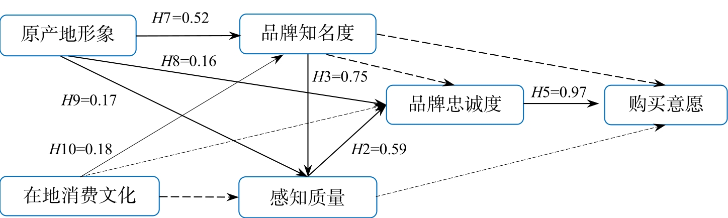
The globalization of capital is the product of the social division of labor and the development of social productive forces. It is also the worldwide expansion of the capitalist mode, and its relations, of production. Trans-local catering brand management is a process of brand remodeling; its general strategy is to re-establish its brand identity, which is unique and different from its competitors', such that the production capital can help establish a new brand image in other countries. Simultaneously, the catering needs of Chinese residents are now different and complex, which meets the self-appreciation needs of foreign capital to a certain extent. Western chain enterprises have become the forerunners of global cultural input, having achieved different degrees of brand remodeling in China in the process of globalization and local cooperation. Although studies have preliminarily explored the phenomenon of trans-local food brand remodeling, it is worth verifying and discussing whether the existing theoretical models are universal and have sufficient explanatory power in the context of the ever-changing international situation and domestic consumption environment. Moreover, few studies discuss brand remodeling from the perspective of the simultaneous effects of two cultures, such as the cultural factors of the home country and the trans-local and post-local cultural factors. Therefore, based on the background of the "spatial turn" and the "cultural turn" this study reflects on the reality of contemporary consumption, empirically analyzes the theoretical path of trans-local catering brand remodeling, and establishes a structural equation model with the culture of brand origin and local consumption culture as the pre-factors of brand equity, to verify the influencing factors and mechanism of trans-local catering brand remodeling. The study finds that the continuous improvement in brand equity contributes to the process of trans-local brand remodeling. The image of origin has a direct and significant positive impact on brand awareness, brand loyalty, and perceived quality. Local consumption culture only affects brand awareness, but has no direct influence on perceived quality or brand loyalty. However, local consumption culture can affect perceived quality and brand loyalty through brand awareness, which then influence purchase intention. Local consumption culture provides the necessary cultural, historical, and political basis for understanding brand meaning in various situations. However, with the development of the economy and the establishment of cultural self-confidence, Chinese people's consumption concept is more rational and pragmatic. Thus, brand reconstruction must be based on the promotion of brand equity. It is not sufficient to have the advantage of brand awareness. Perceived quality is an important intermediary to brand loyalty, which is the only way to develop purchase intention. Although the "halo" effect of the image of origin still exists, good brand quality perception is another important factor influencing customers' brand loyalty and purchase intention. Food quality is the primary factor in the survival of the catering industry, and trans-local catering brands should focus more on the customer recognition of the products themselves. The extent to which the current food experience can directly meet customers' expectations will determine whether customers are willing to pay for the brand continuously. In summary, this study discusses two kinds of cultural and geographical factors, namely the origin effect and local consumption culture, verifies and expands the existing trans-local restaurant brand remodeling model, and verifies the new path hypothesis. It enriches the case study objects and explores the contextualized differences of the theory, thus providing a new case practice for contemporary catering geographical and cultural consumption.
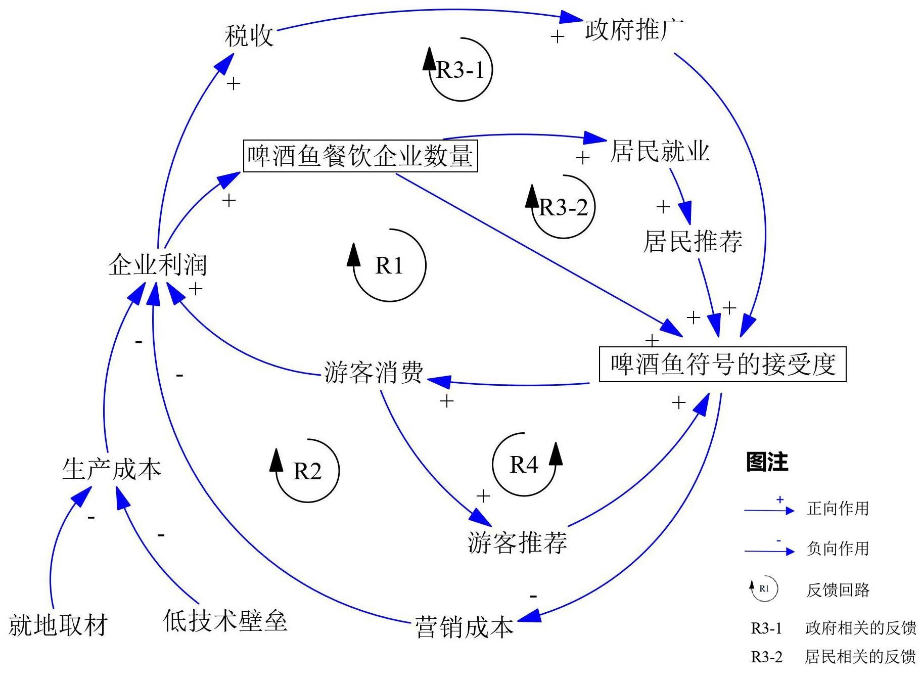
Food symbols with local characteristics are part of the image of a tourist destination, and tourism catering based on local food is one of the important economic activities of such destinations. This study analyzed the formation of the food symbol economy in tourism destinations through the story of Yangshuo beer fish. As a food product with a short history in Yangshuo, beer fish has grown out of nothing and from less to more, and it has gradually evolved into a food symbol of Yangshuo. This study used in-depth interviews, observation, and second-hand data methods to collect data, and analyzed the data through thematic analysis, process analysis, and feedback analysis methods to explore the formation mechanism of Yangshuo's beer fish food symbol economy. It finds that the reason for the food symbol economy is not only the marketing of local characteristics but also the path dependence of product agglomeration. From the perspective of product characteristics, the image of the beer fish aligns with Yangshuo's location on the banks of the Li Jiang River; further, fish is a food that suits local conditions. Additionally, Yangshuo West Street's pub culture is famous, in line with the image of Yangshuo. From the perspective of food production, local materials, high profits, and simple cooking procedures, beer fish cuisine can be produced on a large scale and at a low cost. The barriers to entry for the beer fish catering market are low with strong profit drivers; consequently, new catering companies choose beer fish as the main product. From the perspective of food consumption, the taste of beer fish has local characteristics and is accepted by the public, thus meeting the symbolic and supportive dietary needs of tourists. The recommendations of the government, residents, and other stakeholders further strengthen the image of beer fish. The agglomeration of the services industry can result in the consumption of such products among tourists and generate cumulative appeal, thereby reducing the marketing costs of enterprises. Lower cost and higher sales make the production of beer fish a positive feedback mechanism and lock-in. However, the popular trend of consuming beer fish in the Yangshuo tourist catering market results in an extrusion effect on other catering products. The entry of new products requires high promotion costs, which makes it difficult for other catering products to replace beer fish. This study contributes to the literature in the following ways: 1) combining the path dependence theory to abstract the formation mechanism of tourism destination food symbol economy, it indicates the product characteristics as a tourism destination food symbol based on the market characteristics of tourism catering and the psychological characteristics of consumers. It is an in-depth exploration based on the literature on the production and consumption of tourist food, which has guiding significance for the practice and sustainable development of food in tourist destinations. 2) Since food is a daily necessity, not only the symbolic attributes but also the satisfaction of the consumer's supportive experience should be considered. This research shows the characteristics of tourism catering as a special symbol economy, which is a supplement and specific exploration of the research of symbol and space economies.
The difference in endowment and the implementation of the gradient development strategy have promoted the large-scale cross-regional migration of China's population and have led to a close relationship between population mobility and migration and the spatial pattern of regional development. There has always been a debate about whether population mobility and migration have an expanding or narrowing effect on the regional economic gap. Therefore, the study revisits the topic and uses panel data on 104 cities in the Yangtze River Economic Belt from 2001 to 2017, fully considering spatial dependence based on spatial econometrics models. The main findings are as follows: First, for the global regional economic gap, there is an inverted "U"-shaped nonlinear relationship between population mobility, population migration, and the economic gap, with an expansion effect in the early stage and a convergence effect in the later stage. This is in line with China's gradient development strategy, and is consistent with the phased development concept of "the first rich lead the second rich, ultimately achieving common prosperity." Second, regarding the provincial regional economic gap, population mobility manifests itself as an expansion effect initially and a convergence effect afterward, while population migration only manifests as an expansion effect without a convergence effect. The difference in the effects of population mobility and population migration may be due to the spatial transformation of the economic behavior and resource allocation owing to the latter's household registration (hukou) change, as population migration is a direct output of the economic behavior of the emigration area. Services will be reduced, and the agglomeration effect in moving-in areas will further widen the regional economic gap with moving-out areas. Third, having considered the spatial effect, judging the endogenous relationship between population mobility and migration and the regional economic gap has become relatively complex but more comprehensive and objective; the decomposition of the spatial effect shows that population mobility and population migration are ultimately conducive to the balanced development of the region, in which the spillover effect plays an important role. The study's marginal contribution is breaking the simplified study of the linear relationship between population mobility, migration, and the regional economic gap. The inclusion of spatial effects confirms the non-linear relationship between them. The conclusion is consistent with the reality of the regional development process in China. This study shows that population mobility and migration are not only conducive to regional economic growth but are also conducive to regional economic equilibrium. Therefore, it is beneficial to rationally guide and promote the population flow among regions, and to further reform the household registration system. In future, it will be necessary to deepen the study of the geographical process of population flow and of the law of temporal and spatial evolution and its effect on regional development, paying special attention to the protection of the welfare rights of the floating population.
As an emerging strategic industry with high added value, wide application, and low energy consumption, the software and information technology service industry plays an important role in promoting the development and transformation of the national economy. The reasonable layout of the software and information technology service industry is of great significance to issues such as industrial development and optimizing the urban spatial structure. Based on the registration data of industrial and commercial enterprises, this study uses spatial analysis methods, such as Kernel Density(KDE) and Multi-Distance Spatial Cluster Analysis(Ripley's K), to study the spatial pattern evolution characteristics of software and information technology service enterprises in the main urban area of Chongqing from 2002 to 2017. In addition, this paper uses the Tobit model to explore the impact of location , transportation, industrial agglomeration and policies on the location of enterprises. The research shows that: (1) From the current distribution, the urban middle circle, which is 4-12 km away from the city center, has become the main space for the distribution of software and information technology service enterprises in the main urban area; it forms a "double peak" circle distribution. The spatial distribution pattern is expressed as "one main twice," and the agglomeration feature is remarkable. (2) From 2002 to 2017, while the distribution of enterprises was suburbanized, a large number of enterprises were concentrated 6-8 km away from the city center. The circle distribution changed from a "double peak" structure to a "single peak" structure, and the spatial pattern gradually evolved from a single center to "one main twice"; further, the intensity and scale of agglomeration also increased continuously. (3) Industrial agglomeration has the most significant impact on the location selection of software and information technology service enterprises in the main urban area. The location conditions and intra-city traffic factors have significant impact. The factors of spatial planning policy and external transportation facilities on the selection of enterprises' location are not significant. These research results show that the spatial distribution of the software and information technology service industry in the main urban area of Chongqing presents the characteristics of being concentrated in the middle layer of the city, having multiple centers, and of suburbanization. Compared to software companies in Shanghai, Nanjing, and other cities, the special landscape pattern and relatively backward development stage make the software and information technology service companies in the main urban area of Chongqing have a stronger preference for the urban middle circle. Additionally, the results of the influencing factors of location choice indicate that with the deepening of industry development, the role of various factors in the choice of enterprises' location is also changing. For Chongqing, which is undergoing industrial upgrading, these research findings can provide reference and guidance for the upgrading and transformation of Chongqing's industrial structure, and also provide a basis for understanding the optimization of the urban spatial structure of the main urban area. Nevertheless, due to problems such as data acquisition and the difficulty of quantifying some corporate location factors, this research is possibly inadequate and more in-depth research is needed.
As a key index to evaluate whether a city is attractive or has a healthy, comprehensive, and sustainable development potential, urban vitality is critical to the future development and construction of a city. Exploring the mechanism of how the built environment influences urban vitality from the perspective of urban morphology can be conducive to future urban space planning and design and can provide city planners with quantitative and scientific decision-making support. This study uses urban POI, cellular signaling, and nighttime light remote sensing data from Shenzhen to measure its cultural, social, and economic vitality, which constitutes a comprehensive vitality assessment of the city. Spatial features of these urban vitalities were then analyzed to further illustrate their distribution patterns. Using Bivariate Moran's I method, the spatial autocorrelations between economic, social, and cultural vitality were calculated. From the five dimensions of Density, Design, Diversity, Distance to Transit, and Destination Accessibility, the 5D detection index system was constructed to measure the urban built environment. This study also used GeoDetector to detect and analyze the spatial differentiation between various built environmental factors and comprehensive, economic, social, and cultural vitality and to explore the mechanism of the influence of the built environment on urban vitality. The results show that: 1) The spatial distribution of comprehensive vitality is extremely uneven in Shenzhen, with a higher vitality in the southern and western regions of Shenzhen city and a lower vitality in the northern and eastern regions. Areas with higher comprehensive vitality usually developed along the main roads and metro lines and are distributed in strips along the coastline of central-southern and western Shenzhen. The high-value areas of the urban comprehensive vitality center are primarily concentrated in city- or district-level commercial centers, and employment centers. Comprehensive vitality in Shenzhen reflects social vitality. 2) Urban comprehensive, economic, social, and cultural vitality are significantly affected by the built environment, as indicated by the 5D system. High POI and building density, average building floors, and land use entropy, have significant positive impacts on urban vitality. However, residential population density did not have a significant impact on each aspect of urban vitality. 3) Some interactions between built environment factors had a greater impact on urban comprehensive vitality, such as residential population density, road network density, land use entropy, and road network density. Overall, the interaction between building density, average building floors, land use entropy, and other factors, have a more positive impact on each aspect of urban vitality. 4) The presentation of urban comprehensive vitality is the result of multiple dimensions and factors. In the influencing mechanism of urban comprehensive vitality, building density and average building floors were the fundamental factors. POI density and land use entropy were the direct driving factors. Residential population density was an inducing factor. Distance from the administrative center, intersection density, road network density, metro station density, and bus station density were adjustive factors. The research results therefore provide valuable suggestions for the optimal allocation of resources and the rational layout of urban functional facilities in Shenzhen.
As the endogenous driving force of regional development, the development of urban entities in metropolitan areas has a great influence on the development of the metropolitan areas, while the interactions between the urban entities' systems directly affect the metropolitan areas' development. Studying the relationship between urban entities in metropolitan areas and the basic development law of the structure between urban centers can provide some reference for the planning, development, and construction management of the urban centers and their surrounding areas in the metropolitan areas. Although the core entity territory of Guangzhou-Foshan has been contiguous, its development connection with the peripheral urban territories remains the focus of research. In the context of the synergistic development of the Bay Area, exploring the characteristic relationships between the urban territories in the Bay Area hinterland can provide a positive response to the sustainable development of the Bay Area cities. This study constructs a POI & NPP composite index by a mathematical mean method to determine the POI & NPP composite value and the number of urban centers; Based on the feature that the integrated data will produce abrupt changes at the boundary, the city's boundary extent is then analyzed using the fracture point analysis method. We then analyze the strength and direction of the gravitational force between the urban entities within the Guangzhou-Foshan metropolitan area by adding the modified gravitational force model based on the divided urban-entity territory and the POI & NPP composite index within the scope. The results show the following: (1) A "7+1" urban system structure centered on the core area is formed in the Guangzhou-Foshan metropolitan area. (2) A "heptagonal" positive urban system structure is generated around the core area and a "hexagonal." (3) The urban triangle structure is the basic unit of the Guangzhou-Foshan urban gravitational structure, while the better-developed urban clusters are "Core-Shunde-Nansha," "Core-Shunde–Gaoming," "Core-Sanshui–Huadu," "Core-Huadu-Conghua," "Core-Zengcheng-Nansha," and "Core." (4) The size and structural stability of the gravitational potential of the Guangzhou-Foshan metropolitan area are positively related to the intensity of the urban economic functions.
The interaction between "people" and "land" brought about by recreational activities complicates the original human-land relationship of national parks. As such, the community coordination of national parks has become a significant problem, and the practice of recreational function should be improved. Therefore, it is necessary to consider the linkage development of national park community coordination and recreation utilization in combination with problems of "place" and "space" in human geography and the development trend of the current information age. This study analyzes the spatial reconstruction mechanism of the national park based on the space of flow theory, constructing a spatial linkage logic model for the coordination between recreation utilization and community to supplement new ideas for the development and management of national parks. The results show that: (1) the unique resource endowment of the national park ecological space is the basis for the operation and development of living, production, and recreational spaces. These spaces affect the ecological carrying capacity of the ecological space. (2) The place attachment and cultural identity of local residents in the living space originate from the ecological space, provide cultural resources for the recreational space, and promote the optimization of the production space by improving livability and life security. (3) Production spaces also provide authentic cultural resources for recreational spaces. Through production mode transformation and the increase of employment channels, the income level of aborigines can be improved to drive living space improvement. (4) The economic and cultural capital generated by recreational spaces can contribute to the maintenance of ecological spaces, improvement of living spaces, and optimization of production spaces. Therefore, this study summarizes three aspects: (1) in the future development and management of national parks, it is necessary to promote the scientific management of recreation utilization and community coordination according to the space of flow structure. Relevant national management departments and local governments should be used as the flow control system to improve the talent allocation and fund-raising of national park recreation development and community coordination in order to shape a scientific and intelligent national park co-management and co-construction system by relying on information flow, talent flow, knowledge flow, technology flow, and other elements. Thus, the macro coordination of flow dominance on the nodes involved in community issues and recreational development is strengthened, highlighting the public welfare, scientific, and national leadership of the national park. (2) Based on the spatial reconstruction mechanism, it is necessary to promote the coordinated flow of elements between recreation utilization and the community. First, in combination with the new infrastructure, it is necessary to strengthen the construction of information and transportation networks around the national park and promote the flow of various elements involved in the coordination of recreation utilization and community and the linkage development of the these. Second, with the support of information flow, traffic flow, material flow, and energy flow, we can improve the production and life development of national park communities with limited geographical conditions. (3) Spatial linkage logic needs to be used to improve the diversified development model of recreation utilization and community coordination. To ensure that the ecological space is not destroyed, more attention should be paid to the "recreational landscape" significance of aboriginal living and production space, causing the living space and production space to indirectly contribute to the expansion of recreational space and providing sufficient standardized direction to the industrial linkage of recreational activities of community aborigines.
A metropolitan area refers to the central urban area and its surrounding hinterland. The area plays a strategic role in the development of its regional tourism economy. As a unique form and organization of regional spatial structure, tourist flows in metropolitan areas present different spatial structures and characteristics. However, the existing research on tourist flow is rarely explained from the perspective of metropolitan areas,. Therefore, this study examined the trip strategy data published by tourists, analyzed the spatial correlation characteristics of the tourist flow network in the Shanghai Metropolitan Area (SMA) from the node and network levels by employingsocial network theory and GIS spatial analysis methods and technologies, The results revealed the following: (1) the tourism nodes in SMAdisplayed obvious hierarchical structural characteristics, and the elite scenic spots occupied an important core position in the tourist flow network. Simultaneously, according to the comparative analysis of degree centrality and intermediary centrality, Shanghai tourism nodes, t could be categorized into four types: agglomeration, diffusion, equilibrium, and intermediary. (2) SMA presented a "single-core radial" spatial distribution pattern with Huangpu District at its center, and Huangpu District as the spatial diffusion source, with the mainstream diffusion directions of southwest (central Huangpu District-Songjiang District), southeast (central Huangpu District-Pudong New Area), northwest (central Huangpu District-Jiading District), and a few tourist flows spreading from central Huangpu District to Baoshan District and Chongming County in the north. (3) The topological structure of the Shanghai urban tourist flow network was characterized by low connection, strong diffusion, and balanced distribution. There were five condensed subgroups with high internal and low external correlations. The core-edge division of the network was significant, and the driving effect of the core area on the edge was limited. (4) There was an exponential relationship between tourist flow and the distance between scenic spots inSMA, which had an evident distance attenuation law. However, the attenuation degree in each distance segment was different, and the distance attenuation law of tourist flow was the most significant at 0–20km. Bycomparing the conclusions of this study with other types of domestic tourist flow networks, it was found that various types of domestic tourist flow networks had the same core-edge structure, but the difference lied in that other types of tourism flow networks showed the characteristics of a multi-center balanced structure, and the core nodes were usually high-grade scenic spots, while the tourist flow network in Shanghai was a "single-core radial" spatial structure with the central city as its core, and the core nodes were high-profile scenic spots without grades in the central city. This study provides an example for exploring analyzing the spatial characteristics of tourist flow networks by using the data of network travel notes and optimizing the spatial structure of tourism destinations in metropolitan areas.
With the development of the economy and the improvement in quality of life, the need for leisure tourism is increasing. Rural tourism, which can fulfil people's need to stay away from the city and pursue leisure, has been favored in recent years. From the perspective of tourists and the market, it is precisely owing to the unique characteristics of rural areas, formally called rurality, that people's psychological needs for rural tourism are met. Many scholars at home and abroad believe that rurality, which differs from the city lifestyle, and originated in the countryside, is the core attraction of rural tourism. However, most studies on rurality are concentrated in the field of geography, and relevant scholars have attempted to set up a scale to evaluate rurality or use social semiotics to interpret the connotation of rurality. However, extant research is still unable to identify the elements and structure of rurality from the perspective of tourists' perception, failing to show tourists' cognitive logic in the rural tourism experience or reflect the relationship between rurality and rural tourism attraction. To solve these problems, this study utilizes the qualitative research method combining visitor employed photography with semi-structured interviews, based on the five sensory perceptual systems proposed by Gibson (including the visual, auditory, tactile, taste-smell, and basic orienting systems). A total of 202 rural pictures and corresponding interview texts provided by 20 interviewees were coded to identify the elements and structure of rurality and illustrate the cognitive mechanism of rural tourism attraction from the perspective of tourists' perception. The main conclusions are summarized as follows. (1) First, as per tourists' perception, the rurality structure contains 234 elements and 42 categories, and further summarized into two core dimensions: basic rurality and implanted rurality. (2) Second, in the process of rural tourism, tourists rank rurality elements according to their attractiveness intensity, showing the "core-marginal" perception characteristic of their personal subjective level. Notably, the boundary between core rurality and marginal rurality is blurred, and the possibility of mutual conversion exists. (3) Third, the cognitive mechanism of rural tourism attraction from the perspective of tourists' perception follows the logical development of "Perceptual system—Rurality elements—Rurality landscape—Rural tourism attraction." Under the guidance of these logical clues, the study finds that although rural tourism attraction can be based on a basic landscape, it is also a composite structure, composed of basic, implanted, and integrative landscapes. The core attraction is mostly exerted by the integrative landscape. Overall, the study reveals the elements and structure of rurality from the perspective of tourists' perceptions in the tourism context and analyzes the cognitive mechanism of rural tourism attraction. The research expands and enriches the study of rurality, especially in the field of tourism. Moreover, it plays a guiding role in the development of rural tourism destinations and suggests that rural tourism developers take active steps to create integrative landscapes for tourists.
Dicranopteris is the most representative pioneer species, dominant species and key species in degraded slope land in South China. Dicranopteris could quickly form dense synusia of a single and dominant species. In contrast to the traditional view that Dicranopteris hinders forest regeneration, we found that there are a few species that could settle down in Dicranopteris synusia. We proposed a hypothesis that Dicranopteris synusia could act as an ecological filter. In this study, we transplanted 12 target species seedlings under Dicranopteris synusia with 4 treatments to explore the ecological filtering effect of Dicranopteris synusia, and analyzed the mechanism with soil characteristics. The 4 treatments included the understory removal treatment (UR), the aboveground of Dicranopteris synusia were kept (AF), the root blanket of Dicranopteris synusia were kept (AR) and all of the Dicranopteris were kept (CK). The results showed that: 1) Compared with the red soil under Dicranopteris synusia of Eucalyptus plantation and bare ground, the contents of soil organic matter, total nitrogen, hydrolyzed nitrogen, available phosphorus, available potassium, and exchangeable base ions in the root blanket of Dicranopteris synusia were significantly higher. 2) The majority of the tree species and all of the herbaceous species could not survive with the root blanket of Dicranopteris synusia kept (AR and CK). The species that could survive with the root blanket of Dicranopteris synusia kept were Schima superba, Rhodomyrtus tomentosa, Ilex asprella and Melastoma candidum. The results indicated that Dicranopteris synusia could act as an ecological filter. The key lies in the role of root blanket of Dicranopteris synusia, and not in the improvement of soil nutrients. Theoretically, Dicranopteris synusia, especially the root blanket of Dicranopteris synusia, is closely related to the breakthrough of biological threshold for ecological restoration. In the future, it is necessary to further analyze the structure and function of the root blanket of Dicranopteris synusia. In terms of application, there are a large number of plantation types (such as Eucalyptus plantation) that Dicranopteris occupied as a single dominant understory species in South China. Therefore, we should pay more attention to the ecological filtering effect of Dicranopteris synusia in structural optimization and stand transformation. This study could provide a reference for the restoration and reconstruction of degraded slope land in South China.