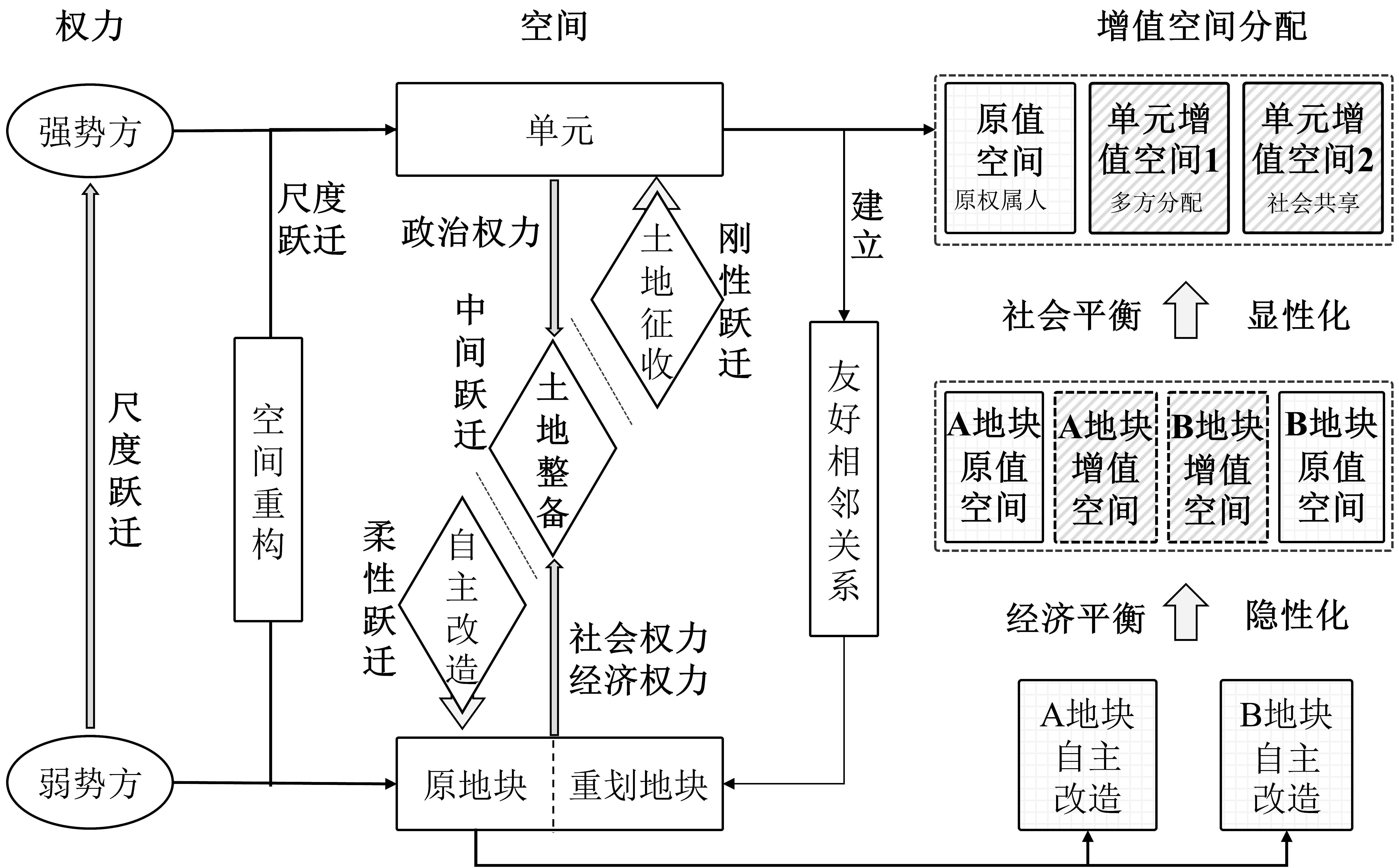
The key factor that influences the progress and operational efficiency of a reserved land redevelopment program is the rationality of land value increment allocation. Scaling-up has become a type of spatial governance instrument. During land redevelopment, there are three types of scaling-up statuses: self-transformation as flexible scaling-up, land acquisition as rigid scaling-up, and land consolidation as medium scaling-up. This paper establishes a framework for research on land value increment allocation in land redevelopment from the perspective of rescaling, taking Guangzhou Haizhu Bay Transport Hub and its surroundings as a case study. Three redevelopment pattern types (self-transformation, land acquisition, and land consolidation) were observed based on the scope of scaling-up, the effectiveness of land value increment allocation, and progress of redevelopment programs under different scaling-up models. On a plot with single ownership, flexible scaling-up can be regarded as a financially oriented self-transformation. The non-transparent mechanism of land value increment allocation is likely to squeeze society-shared benefits derived from land appreciation of a "unit", which tends to make it difficult to promote self-transformation programs. Rigid scaling-up can be considered as land acquisition under government control. It focuses on land as a "unit" and financial balance, compiling land acquisition and banking proposals. The powers of multiple stakeholders are not equal during the processes of land acquisition. The non-transparent allocation mechanism of land value increments, led by the local government, is likely to induce new conflict from original landowners, leading to impediments of such programs. In medium scaling-up, land consolidation is based on interactions among the multiple stakeholders. It satisfies practical demands of land redevelopment programs by coordinating interrelationships between power and space. The "banking-transforming" land consolidation approach promotes cooperation on land redevelopment among the multiple stakeholders, and synergistic value-added effects can be attained. The establishment of transparent mechanisms aims to improve fairness and rationality in land value increment allocation, achieving balance between societal and financial benefits in a "unit", and guaranteeing its land supply. This paper proposes three rational paths for land value increment allocation in land redevelopment. From the point of power, it establishes a coordinated mechanism of land consolidation based on authoritativeness of upper governments. From the point of space, it constructs a carrier for a land consolidation "unit". On the aspect of land value increment allocation, it builds up a transparent mechanism with societal-financial benefit balance. In further study on land redevelopment, more attention should be paid to utilizing scaling-up instruments rationally, to transforming space reconstruction patterns, and to innovating transparent allocation mechanisms for land value increments. This application of rescaling theory provides a reference to practical programs for improving the efficiency of land redevelopment, and for promoting area integral high-quality development.
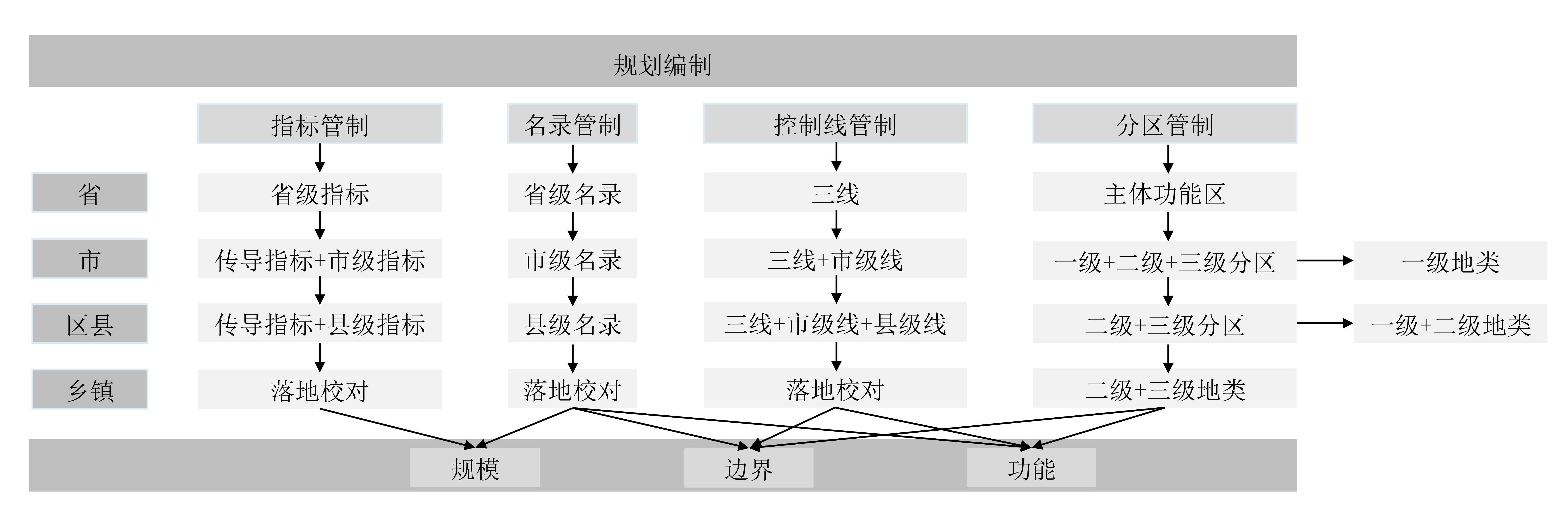
The paper reviews the current focus and future direction of China's research in the field of territorial space use zoning and aims to provide a scientific basis for China's spatial planning and territorial and spatial land management with the wider goal of improving the system of ecological civilization to promote the modernization of national governance systems and governance capacities. We use CiteSpace, a visualization software and method of bibliometric analysis, to create a knowledge map and systematically categorize the research trends and development context of territorial space use zoning research, based on 662 relevant papers published from 1979 to 2020 and cited on HowNet. Research on territorial space use zoning in China continues to emerge, and the number of published papers is increasing. The research was divided into three stages: the land use zoning stage (1992-2006), the natural ecological space use zoning stage (2007-2017), and the territorial space use zoning stage (2018-present). The main research keywords in the three periods show that scholars have consistently maintained an enthusiasm for the study of "land use". The keyword "land use" had a high centrality of 0.28. Close cooperation among authors formed a large-scale scientific research cluster. Colleges and universities published the most, followed by scientific research institutions and public institutions; the main outputs of public institutions such as China Land Surveying and Planning Institute are policy documents, the influence of which should not be underestimated. 2) The research on territorial space use zoning was national policy-oriented under the profound influence of the changing background of the times. Zoning theory developed from the theory of geographical differentiation and advantageous location into the concept of main functional zone regulation, and then to the present concept of sustainable development. Zoning systems were constantly optimized, and research focuses were diverse. Some provinces and cities conducted practical explorations based on local conditions because of "Three zones and three lines". "Three zones and three lines" refers to the areas corresponding to the three types of urban space, agricultural space, and ecological space, and the three control lines corresponding to the urban development boundary, the permanent basic farmland protection red line, and the ecological protection red line. In the face of the complexity and dynamics of territorial space, research methods have changed from qualitative or quantitative methods to focus on the application of modern science and technology. Most of the research on zoning control focuses on three aspects: discovery of existing problems, enlightenment from foreign experience, and research on zoning practice. Considering the existing problems, such as conventional research contents, shallow scientific validation studies, insufficient theoretical improvements, few applications of multidisciplinary integration and big data, future researches should focus on four directions as follows: carrying out the theoretical research related to territorial space use zoning; deepening use zoning research on ecological space, marine space and rural construction space; broadening the research perspective of territorial space use zoning based on the construction needs of territorial space use control system; implementing innovative methods and technologies for application based on multidisciplinary integration.
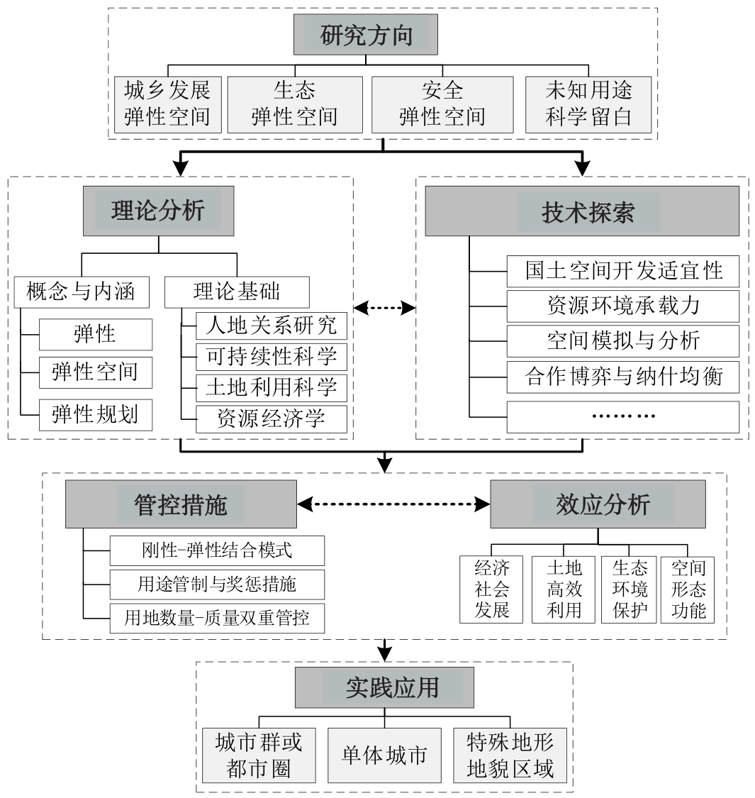
The proposal and delineation of flexible space is an effective approach to promote innovation in territorial management, improve the scientificity of spatial planning, and meet practical demands in the context of significant economic and social transformation. However, existing research focuses on preliminary theoretical exploration and case studies on individual cities/regions and is inadequate from the perspective of systematic and integrated research. We used visualization analysis software (CiteSpace5.6) to develop a knowledge graph of flexible space research based on more than 800 articles published between 1990 and 2020 on the topic of "Flexible Space" and "Flexible Planning", retrieved from two databases ("Web of Science" and "China National Knowledge Infrastructure"). The research drew the following conclusions: 1) The quantity of English literature had a significant upward trend, but the amount of Chinese literature increased first and then decreased. Most research focused on eco-environmental and engineering perspectives, and ecosystem services and land use suitability evaluation became the novel direction. 2) The cooperative network density of scientific research institutions related to flexible space research was 0.0042, indicating a relatively low degree of cooperation. The segmented cooperative network centered on several institutions including the Chinese Academy of Sciences and the University of Queensland in Australia, etc. 3) The most common knowledge groups included the concept and connotation of flexible space, flexible planning methods, and regulation measures. Features such as land reservation, mixed utilization, and space replacement were emphasized in the descriptive terms, while the use of spatial and quantitative analysis models for spatial optimization and evaluation of suitability were technical focuses,and the most widely adopted methods included decision support systems and agent-based models. Various regulation measures were proposed, with the "rigid-flexible combination" approach being amongst the most widely used. To promote theoretical and systematic research on flexible space, the theoretical framework should be built first as a general guide to related research. The theoretical basis and technical methodology should be improved with the support of multidisciplinary integration to enhance the scientificity and feasibility. Moreover, more case studies on various research areas should be carried out to improve the practicability.
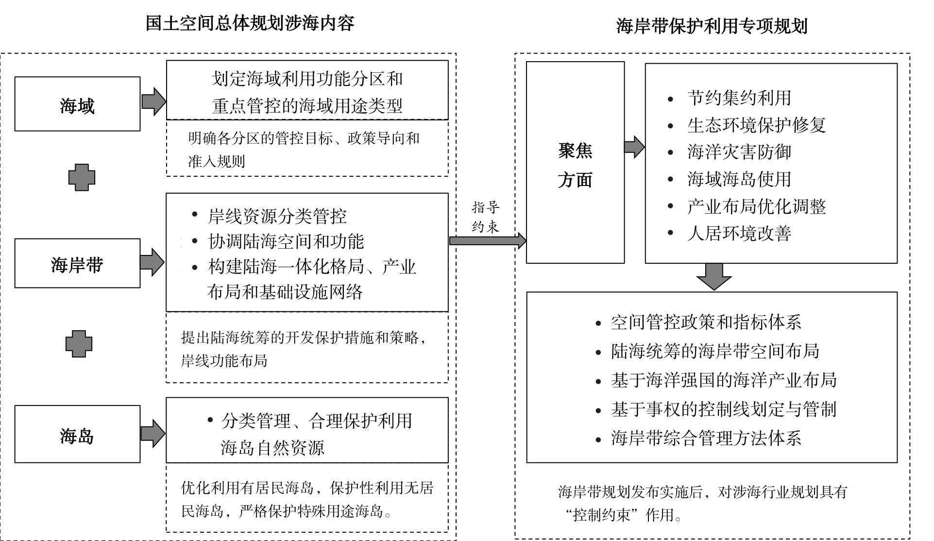
In the reform of the territorial spatial planning system, The strategy how to adhere to the overall planning of the land and the sea, and to realize the whole area and all elements is one of the key tasks of planning the reform of the territorial spatial planning system. In the new era, territorial spatial planning is primarily faced with problems such as differences in the preparation methods of land and sea overall planning, single land and sea resource evaluation methods, and imperfect coastal zone management systems. "Protective utilization characteristic," that is, three-in-one, land-ocean overall planning model, basic principles, and management and control ideas were put forward suggested, as well as land-ocean overall planning and space management and control systems were also proposed. Starting from the perspective of unifying the control of land and space use, taking Guangdong Province as an example, and based on a comprehensive review of the control objects, content, means, and implementation effects of land and sea coordinating key areas, it was proposed that ecological protection and bottom-line control should be given priority, and including innovative land management and control methods such as the management and control mechanism for the overall planning of the sea area, the marine ecological environmental protection system, the key coastal resource project library, and the three-dimensional layering of land and sea use rights be prioritized. It is expected that we seek a new path suitable for our country's characteristics on how to reflect the concept of land and sea overall planning in the preparation for land and space planning.
Establishing a rational and clear territorial spatial planning implementation system is key to ensuring governance effectiveness. Following the formulation of territorial spatial planning at all levels, the planning system, from the perspective of formulation, has already been formed. However, from the perspective of implementation, neither holistic research nor empirical case studies have been discussed thoroughly. On the basis of Guangzhou's territorial spatial planning, this paper analyzes the problems underlying the existing planning system. To achieve the goals of all regions and elements that are covered by spatial planning, this paper puts forward suggestions for the implementation system based on the integration of duty, system, and content, which raises the targeting advices on Guangzhou's planning system,including four vertical transmission levels of "City-district-unit-plot", as well as the horizontal coordination of overall level planning, detailed level planning and special planning. It aims to provide a reference for other cities. The major conclusions of this paper are as follows. First, under the vertical implementation aspect among all levels of planning, integration with the "city-district-town" administrative system should be reinforced. To this end, the vertical planning implementation system of the "city-district-unit-lot" should be formed. Moreover, the contents of implementation should focus largely on objectives, control lines, land use, and public facilities. To be specific, the objectives from overarching strategies should be subdivided into sub-strategy indicators and action plans. In terms of control lines, categories of "big three control lines," including ecological protection line, permanent basic farmland protection line, urban growth boundary line; "small three control lines," including green space protection line, water system protection line, historical and cultural protection line; and other natural resource protection lines should have differentiated implementation and control methods. This paper argues that the following three methods should be followed: amount determination with boundary delineated, amount determination with boundary illustrated, and indicators determination with boundary of core elements illustrated. In land use management and control, this paper argues that the precision of land use control should be extended from functional policy area to dominant use zoning. Furthermore, development capacity zoning should be emphasized as the basis to promote the compatibility of land use, population, and total floorspace. Last but not the least, public facilities should be allocated according to the three-tier system: city-level, district-level, and community-level. Control guidelines must also be reinforced, which includes facility standards, land boundaries, allocation points, and facility scale. Second, using horizontal implementation, this paper suggests that a "connection-retroaction" mechanism should be established, including special, comprehensive, and detailed planning. Above all, the formulation of special planning should be synchronized with comprehensive planning in order to reach a consensus about planning lists, core planning elements, and collaboration mechanism. Thereafter, the rules to implement special planning among all planning levels should be clear. Detailed standards, indicators, directory, structure, and location implementation should be the major factors in rule setting. Although there are great differences in planning system, organization, and management mode among cities, Guangzhou still has representative significance. It can provide reference for the research and establishment of territorial spatial planning and implementation in China.
The decline of community publicity in the post-unit era is the social feature of economic system transformation. Exploring the spatial evolution mechanism of post-unit community is of great significance to sustainable community governance. By bridging Lefebvre's ternary spatial structure and Bourdieu's four capital types, a research framework of space production is established based on field theory and practice. Taking Xukuang community as a typical case, the qualitative research methods of participatory observation and in-depth interview are used to analyze the multidimensional spatial production process from "unitary continuous network structure" to "multiple discrete group structure". The research shows that: 1) The spatial production difference mechanism of unit to post-unit community transformation is shaped by the institutional change from unit system to community system, on the other hand, it is affected by the factors such as the free flow of modernity and the adjustment of regulatory structure. 2) Post-unit community actors adjust their habits in the reorganization of residents' composition and power relations. The process of competing for community capital is accompanied by the reconstruction of institutional space, the transformation of material space, the alienation of social space and the awakening of subject consciousness. 3) The government discourse represented by the neighborhood committee adopts the discipline strategy to build an ideal community space in the space practice, and forms a connected but not integrated overall relationship with potential residents' resistance. Especially when the production of capital and power touches the boundary of the subject or the emergence of individual critical subject, it often leads to new space struggle, habit adjustment and the direction change of space practice. 4) The space production of post-unit community is jointly driven by the subject of right discourse and the subject of daily life. The promulgation and response of the old community transformation policy from the state to the local construct the expected vision of community governance from the macro level. The power game and inclination of actors mean the sinking and implimentation of the production strategy of the government power subject at the meso level. Under the background of the accumulation of unit path dependence, modernization and aging, the post-unit community as the undertaker encounters the lack of kinetic energy at the micro level, the deconstruction of acquaintance society and the reconstruction of stranger society, and the realistic context contrary to the concept of multiple governance produced by the top-down strong power transmission and the bottom-up weak residents' feedback. The research integrates the concepts of field capital and habitus into the ternary dialectical structure of space production, and the in-depth theoretical integration makes up for the cognitive limitations of the single theoretical perspective. It expands new ideas for the in-depth understanding of the spatial evolution and subject relationship of the old community represented by the post-unit community. And the consideration of people's subjective initiative and social culture to a certain extent broadens the logic of space production in the general sense, which is also a supplement to the existing literature on community governance. Finally, it is an important direction for future community governance to formulate governance goals and countermeasures with residents as the core and promote the common enjoyment of community power.
The aim of rural revitalization is to improve the prosperity of farmers. However, farmers are not purely "economics-driven people." In fact, their behavioral logic is driven by internal emotions, which can affect the external environment. At the same time, changes in the external environment can alter a farmer's emotions toward the place. Therefore, research on the emotional reconstruction of farmers in villages where poverty has been alleviated is not only conducive to guiding the direction of construction and governance of such villages and maintaining their harmonious and stable development but also helpful for retaining "returning" farmers. These farmers make up for the absence of the "main body" of the economic development of the village, all of which is significant for the smooth realization of effective connections between poverty alleviation and rural revitalization. For this article, Shibadong Village in Huayuan County, Hunan Province was chosen as the case study, with the "left behind" farmers and "returning" farmers in the village as the research subjects. From the perspective of emotional geography, we used in-depth interviews and participatory observation methods to explore the emotional reconstruction of the farmers and the related mechanism involved under the influence of the targeted poverty alleviation policy. The research showed that 1) the emotional reconstruction of farmers in poverty-alleviated villages mainly includes the reconstruction of five perceptions sense of belonging, sense of happiness, sense of risk aversion, sense of relative deprivation, and sense of loss. 2) The implementation of the targeted poverty alleviation policy has optimized or improved the material space, industrial structure, economic income, and governance services of poverty-alleviated villages, resulting in increases in the farmers' senses of local belonging and happiness and a decrease in their sense of risk aversion. However, an imbalance in poverty alleviation efforts leads to an enhancement of their sense of relative deprivation. The dissolution of traditional cultures and the reconstruction of social relationships result in the farmers feeling lost. These five senses of emotions affect and restrict one another. 3) In the process of emotional reconstruction of farmers in poverty-alleviated villages, the cognition of the individuals is the core force of the process. However, farmers find it difficult to make long-term and wise decisions because of their low cognitive level, which is not conducive to the positive development of emotions. As the leading force driving the emotional reconstruction of farmers, the government—through various poverty alleviation measures—coordinates the order of other individuals participating in poverty alleviation governance, optimizes the rural regional system in the poverty relief village, and improves the farmers' cognition to reshape their local emotions. Enterprises play an auxiliary role in this process, participating in poverty alleviation in various ways. In addition, they facilitate the market economy in optimizing the allocation of resources and improving both the efficiency of poverty alleviation and the resilience of poverty-alleviated villages to resist risks. To consolidate the achievements of poverty alleviation and realize rural revitalization, poverty-alleviated villages should take relevant measures based on the characteristics of emotional space, time, sociality, and hierarchy to cultivate positive emotions, and reduce negative ones, in the farmers. Use of the "place-emotion-behavior" analysis model is helpful for elucidating the interactive processes between the emotions, behaviors, and social material environments of farmers and the significance of those individuals in the reconstruction of the rural regional system in the context of macro policies. This article provides a useful reference for promoting the effective connection between targeted poverty alleviation and rural revitalization.
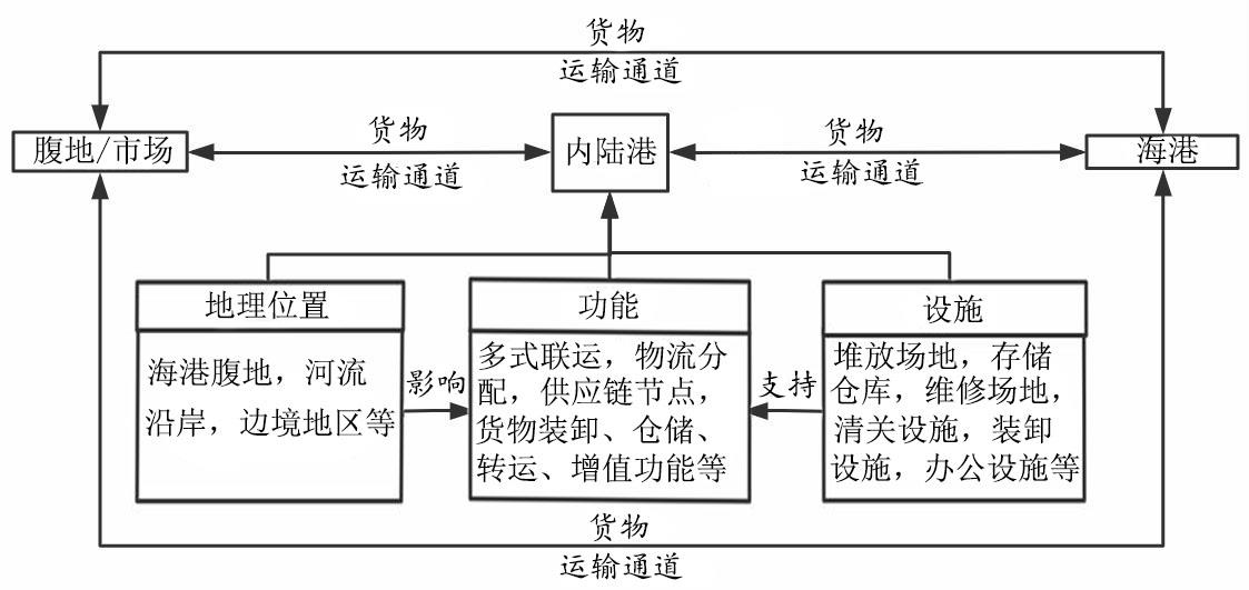
The proposal of a national strategy for the "New Western Land Sea Corridor" will affect the reconstruction of the overall freight distribution pattern in western China. As the most important hub node for cargo distribution and transshipment in inland areas, the inland port (or dry port) is of great significance to regional economic development, logistics systems, and the construction of a new regional development pattern. Therefore, 111 papers on inland port research in international core journals have been selected in this study to systematically review the research status of inland ports and put forward the key directions and development trends for future research to serve the theoretical research and construction planning practice of inland ports in China, and globally. In this study, the literature metrology method is adopted to divide inland port research and development into three stages: the first stage is the initial stage (before 2005); the second stage is the slow fluctuating growth stage (2006-2017); the third stage is the rapid increase stage (2018-present). Scholars are interested in inland port research mainly from mainland China, the Netherlands, Hong Kong, the United Kingdom, the United States, and other countries (regions). Related research topics on inland ports are mostly combined with transportation, logistics, and other fields, which indicates that inland ports have become an important part of transportation systems and supply chain transportation networks. Among specific related research topics, the concept of inland ports is an important research topic, mainly focusing on the differences in naming and function, facilities of inland ports under different geographical backgrounds, and additional functions extended with economic development; however, its concept has not yet been unified. Research on the spatial layout system of inland ports shows that the inland port site selection and layout can be roughly summed up as a supply chain-oriented pattern, and industrial cluster-oriented pattern; the former often near port cargo distribution of traffic nodes, while the latter is on the border between the end of the supply chain. The location and layout of inland ports are influenced by economic foundation, transportation infrastructure, and local policy factors. Inland ports have a profound impact on the region. In terms of spatial effects, they have an impact on urban spatial planning and land use; in terms of economic effects, they can promote regional economic development and employment; in terms of environmental effects, they can reduce energy consumption and emissions, and promote the realization of regional sustainable development. In the operation and control of inland ports, special attention should be paid to the relationship between port planning and each manager, as well as to the management system, to realize the efficient, sustainable, and healthy development of inland ports. Finally, based on the new trends of global inland port logistics research and the realistic demand of China, we put forward several suggestions for future research, including the redefinition of dry ports, spatial layout and planning of inland ports, their regional influence, the port-city relationship, risk of investment, and potential benefits of inland ports.
Since the Reform and Opening Up, urban agglomerations have developed rapidly. However, issues in the developmental process such as destruction of the ecological environment and uncoordinated internal development have hindered high-quality development, and the question of how to ensure the optimal development of urban agglomerations has received wide attention worldwide.The trend of development of urban agglomerations has been towards polycentric cities, with the middle reaches of the Yangtze River urban agglomeration comprising three city subgroups with obvious polycentric structure. However, Wuhan metropolitan area has an obvious centric structure; and the growth pole of Poyang Lake urban agglomeration is not prominent, the interactive development of peripheral cities of the Changzhutan urban agglomeration is insufficient, and the internal development of the urban agglomeration is uncoordinated. To promote the coordinated and sustainable development of the middle reaches of Yangtze River urban agglomeration, the gravity of the leading political and economic growth poles of the middle reaches of Yangtze River urban agglomeration was examined while improving the gravity model and geo-coefficient. The potential urban development of each prefecture-level city in the urban agglomeration was measured, the evolution of the spatial structure of the potential growth cities was explored, and the potential growth poles in the region were confirmed by combining the needs of coordinated development of the urban agglomeration. The study aimed to promote the regional economy to the level of high-quality development through optimizing the spatial structure of urban agglomerations, to provide explorative directions for promoting coordinated development of large, medium, and small cities. The study showed that 1) the potential development cities in the middle reaches of the Yangtze River urban agglomeration were unevenly distributed, with Hunan, Hubei, and Jiangxi provinces, respectively, having "high-value equalization", "double-core" and "single-core" network structures. 2) The absolute geopolitical coefficients had clear geographical differentiation. The geopolitical coefficients of cities outside Hubei were mostly smaller than the medians, meaning that the economic gravity was smaller than the political gravity, whereas the three urban subgroups had more internal connections while there were relatively few links between provinces. Hunan and Jiangxi provinces were characterized as "low center and high surroundings". The best geopolitical coefficients were of "bimodal" form and the development level of cities that were under the influence of political gravity was better than for those under the influence of economic gravity. (3) The potential growth cities had characteristics of "marginality" and were concentrated in the southwest and the periphery of urban clusters. In 2017, the overall potential development of Hunan Province was similar to that of its urban centers, tending to be "high-value balanced". It was the province with the greatest potential for cultivating potential growth cities. The "siphoning effect" of Wuhan City was obvious, and the cities with slight potential were the most "marginalized" in the Hubei Province owing to their geopolitical distance. Urban development in Jiangxi Province was more erratic, and its overall potential development was not outstanding. (4) Three primary growth poles in Zhuzhou, Xiangyang, and Jiujiang and three secondary potential growth poles with realistic needs in Hengyang, Yichang, and Xinyu were identified by combining the potential and coordinated development of urban clusters.
The coordinated development of jobs and housing spaces is of great importance for the rational allocation of urban functions and residents' quality of life. We focus on the measurement of the spatial relationship between working and living space in a mountainous city and the impact of industrial and topographic factors, with the main city of Chongqing as the study area. Using the employed population and residential population as identified by Baidu Huiyan, this paper analyzes the relationship between jobs and housing spaces in the central city of Chongqing by calculating the degree of job-housing deviation, dividing the study area into three groups: the Employment-Dominant Area (EDA), the Balanced Area (BA), and the Residential-Dominant Area (RDA). Factor analysis and window analysis are then applied to explore the impact of industrial and topographic factors on job-housing space based on the Fourth National Economic Census. We find that, first, the spatial distributions of employment and the residential population in the central city of Chongqing are basically the same, showing the characteristics of "high in the middle and low around" and a polycentric spatial structure; there is spatial overlap between the areas with the densest employment and residential population, such as Jiefangbei, Qixinggang, and Nanping. Second, the job-housing space in Chongqing is basically balanced; the deviation of work and residence in most suburban districts is not obvious. The sub-districts with the highest Standard Deviation (SD) are mainly concentrated in the employment-dominant areas within the outer ring, while a few are distributed in the residential-dominant areas. The multi-center structure shows a low job-housing balance in the main center (Jiefangbei) and a high job-housing balance in the four sub-centers. Third, industrial factors and relief amplitude have a great impact on job-housing balance in Chongqing's main urban area. Using SD as the dependent variable can better explain the influencing factors. The integrated service industry factor and the production service industry factor exacerbate the separation of jobs and residences because of their ability to attract the employment population. In the meantime, the social service industry factor, manufacturing factor, and relief amplitude reduce the difference between jobs and residences. In addition, urban spatial structure, traffic patterns, government planning, and residents' attributes are important factors shaping the job-housing space in the Chongqing main area.
The exhibition industry is characterized by high efficiency and high economic relevance, making it one of the most active components of China's modern service industry. Previous studies have revealed that the competitiveness of the urban exhibition industry results from multiple factors, such as the scale of the exhibition industry, the level of economic development, related facilities, and the service industry in cities. However, a few cities in China have ignored their functional positioning and resource constraints in recent years, thus blindly constructing super large-scale venues that far exceed demand. This abnormal phenomenon shows that the level of coordinated development among elements significantly impacts the urban exhibition industry. Therefore, this study focuses on the coordination of the key supporting elements for the exhibition industry. First, we constructed a comprehensive index system to evaluate the competitiveness of the urban exhibition industry, which consisted of exhibition industry vitality, economic strength, and reception capacity subsystems. Second, we used the coupling coordination model of physics to calculate the coupling coordination degree among these three subsystems in Guangzhou, Shenzhen, Dongguan, and Zhongshan. The exhibition industry of these four cities develops most prosperously among the mainland cities in the Guangdong-Hong Kong-Macao Greater Bay area. By comparing the results between these four cities from 2013 to 2019, we aimed to explore the constraints of the coordinated development of the urban exhibition industry's competitiveness system and the interactive mechanism between subsystems. These results show a significant hierarchical difference among the four cities in the level of coordinated development of the exhibition industry's competitiveness. Guangzhou and Shenzhen have already reached the premium coupling coordination stage, where subsystems resonate benignantly, and the degree of coupling coordination is relatively high. In contrast, the degree of coupling coordination is still low for Dongguan and Zhongshan, indicating that the exhibition industry is developing extensively in these two cities. The coordination mechanism is a process wherein the exhibition industry vitality, economic strength, and reception capacity subsystems are synchronized and closely integrated toward the same direction. In this situation, the subsystems develop to a certain level, and the mutual forces between them form a loop that circulates both clockwise and counterclockwise, with the exhibition vitality acting as the core, the reception capacity as the foundation, and the economic strength as the development element. Different cities have diverse main constraints on the coordinated development of the exhibition industry's competitiveness. For first-tier cities, their comprehensive service capability is more crucial than their economic strength, which is related to the market size of the city's exhibition industry. For non-first-tier cities, their economic strength often determines whether the urban exhibition industry that serves the local area can have an impetus for sustained growth because the overall service industry is underdeveloped.
As a landscape with special significance, the landscape of fear exists in nature and human society. It has a huge ecological effect in biological system, and also has a profound impact on all aspects of material landscape and collective memory in man-land system. Landscape perception, landscape attitude and the interaction between landscape and human are important topics in contemporary geography research, but the research on the landscape of fear is still weak. Based on this, the study systematically sorts out the concept and research content of the landscape of fear, and discusses its application in tourism geography. The main conclusions of the study include: Firstly, the landscape of fear has formed fear ecology in the research from the perspective of ecology, and it is still in the exploratory stage in other disciplines. Although Tuan Yifu first put forward and studied the landscape of fear thoroughly from the perspective of human geography, the research on humanity society, geography and other related aspects is scattered. On the contrary, it is currently applied to ecological research and has rich research results. This shows that in addition to the maturity of its research in ecology, the landscape of fear in other disciplines remains to be explored. Secondly, under different disciplinary perspectives, the definition and research content of the landscape of fear are different, but in essence, its formation cannot be separated from the influence of subjective fear and external environment. On the one hand, the definition and research content of the landscape of fear in ecology are relatively consistent, which are animal predation risk perception. On the other hand, in other research disciplines, the concept and research content are mainly studied from the presentation form and perception of the landscape of fear between people and place/space. There are some differences in the research of the landscape of fear from different perspectives, but the "fear" perception of it must have an objective object that causes its fear. The landscape of fear is formed by the combination of subjective psychology and objective external. Thirdly, from the relationship among the landscape of fear, tourists and emotion, this paper finds that the application of the landscape of fear in tourism geography mainly focuses on emotional geography, dark tourism and emotional characteristics. There is no clear definition and research on the landscape of fear in tourism geography, but it can reflect the significance of the landscape of fear from the research contents such as emotional experience, dark tourism and memory of the place. Finally, the future prospects of the landscape of fear can be studied in tourism geography are as follows: 1) Based on its particularity, the landscape of fear in tourism geography will be discussed more deeply from different perspectives. 2) The psychological changes and emotional experience of tourists facing the landscape of fear can be studied. The emotional connection between man and land is one of the focuses of tourism geography research, and the landscape of fear integrates the complex emotions between people and landscape. And the emotional expression of the landscape of fear and the psychological impact of the landscape of fear on tourists can be studied. 3) Take dark tourism as the starting point to explore the landscape of fear. Dark tourism inevitably involves the research of tourism geography, and there is a certain connection between dark tourism and the landscape of fear. From the perspective of dark tourism, we can deeply explore the association with the landscape of fear, so as to better integrate the research of the landscape of fear and emotional geography. Although there is still a lack of research on the landscape of fear in humanity society, it has great research space. This paper combs and analyzes the landscape of fear and explores its application in the research of tourism geography, in order to enhance more attention and deepen its research in the field of tourism geography.
Tourism urbanization produces a transfer and concentration of elements, which greatly promotes the reshaping of urban spatial patterns. As a concentrated expression of urban tourism elements, tourism and leisure business pattern is the main factor in shaping the spatial pattern of tourism cities, while the public transportation network structure is the product of the interaction between urban space and functional elements. The interaction influence law between them presents unique characteristics in space against the background of tourism urbanization. Therefore, to study the spatial correlation between the public transportation network and tourism and leisure industry patterns in the context of tourism urbanization, this study uses the main urban area of Lijiang as a case study, and introduces transportation network centrality as a key indicator to portray the accessibility of public transportation in the urban activity space and urban transportation location advantage. It constructs a comprehensive public transportation network centrality indicator by effectively integrating network polycentricity indicators and portrays the spatial pattern of the tourism industry based on urban POI data. It uses the spatial data analysis method to analyze the spatial distribution characteristics and patterns of the public transportation network centrality and tourism and leisure business. Additionally, it employs the bivariate spatial autocorrelation model to analyze the spatial coupling between the two. First, the research shows that the centrality of the public transportation network shows a "core-edge," cross-shaped, mono-core structure centered on the ancient city of Lijiang, while the suburbs form a relatively scattered and independent block structure, consistent with the law of distance decay. Second, the tourism and leisure industry in Lijiang as a whole forms a spatial distribution pattern of block-like aggregation, north-south axial extension, and multi-center cluster development, showing the typical characteristics of the development of the surrounding tourism and leisure industry that is driven by the ancient town's scenic spot as the focal point. Third, the spatial distribution of the five operational types of tourism and leisure industries all show a significant positive spatial correlation with the centrality of the public transportation network, Meanwhile, the spatial distribution of the two types of industries—hotel accommodation and tourist attractions—is highly dependent on the ancient town under the influence of its tourism business model, and the high concentration of facilities and resources results in an overall lower degree of centrality of coupling with the public transport network than the other three types of industries: catering, shopping and entertainment. Fourth, the local spatial coupling pattern is dominated by high-high aggregation and low-low aggregation, while the ancient city and its surroundings typically represent the high-high aggregation area. This is not only an important bearing space for the tourism and leisure business elements, but also a hub of the urban public transportation network, which effectively explains the directionality of the public transportation resource allocation against the backdrop of tourism urbanization. Fifthly, the spatial coupling relationship between the spatial pattern of tourism and leisure industry and urban public transportation network is the result of the role of factor concentration and function spillover in the process of tourism urbanization, and the interaction law of the two is the reflection of the spatial emergence of the coupled subsystem under the role of tourism urbanization. Based on the two-way perspective of public transportation and tourism, this study conducts empirical research with a typical example of tourist cities, with the aim of deepening the understanding of tourist elements and the layout of the public transportation network in tourist cities. It reveals the spatial characteristics of tourist urbanization in the current development stage and provides an idea to realize a comprehensive urban service space of host-guest sharing for tourists and local residents. Additionally, this study offers a practical reference to promote a rational allocation of urban public transportation resources to realize the sustainable development of tourist cities.
The image of tourist destination is an important field in the study of tourism geography. The cognitive results of tourists' subject experience embodied image play an important role in the loyalty, satisfaction and development of tourist resources. In order to further explore the constitutive dimensions of tourists' images of corridor tourist destinations, this paper uses the Internet travel notes containing tourists' memory and narrative information to construct five dimensions of images of corridor tourist destinations,using qualitative analysis and GIS research methods. Finally, the following conclusions are drawn: 1) The image of corridor tourism destination is a complex dynamic process, which is the synthesis of cognition, imagination and emotion in the process of tourists' corridor experience. The construction of tourist destination image is of great significance to the construction of destination planning. Therefore, this paper deconstructs tourist image dimension with the help of grounded theory coding method, and finds that the image dimension of corridor tourism destination is constructed from five dimensions:linear image, color image, aesthetic image, local image and emotional image; 2) In order to deeply analyze the emotional results of tourists during corridor tourism, and to explore the emotional tendency of tourists by relying on emotion analysis tools, it is found that in the presence experience of tourists from "Sichuan-Tibet Line" in southern Anhui, positive emotions dominate, while negative emotions account for a relatively small proportion; 3) Through the analysis of key word frequency of travel notes, it is found that the perception features of the image elements of "Sichuan-Tibet Line" in southern Anhui show two levels: dynamic and static combination, linear experience and perception; 4) Relying on the spatial analysis function of GIS, the hot spots of tourists' perception of image elements are extracted, and finally it is found that the image cognition hot spot of "Sichuan-Tibet Line" in southern Anhui is presented in four dimensions: linear corridor, color, aesthetics and local.
There are many species of terrestrial Mollusca with rapid reproduction rates, a wide distribution range, and a large population. They are not only an important wildlife resource but also an important component of biodiversity. Previously, basic research has been conducted on the species diversity and distribution of terrestrial Mollusca in some nature reserves in Guizhou and Yunnan. The existing sample data of terrestrial Mollusca in Guizhou and survey results from Guiyang, Libo, and Xishui from July 2019 to December 2020 listed 316 species and subspecies (including 13 undefined species) belonging to two subclasses, four orders, 20 families, and 76 genera in Guizhou Province. From the perspective of species composition, the dominant family is Cyclophoridae, with 16 genera and 71 species; the second most dominant family is Bradybaenidae, with 15 genera and 61 species, followed by Helicinidae and Cochlicopidae with one genera and one species. The dominant species are Kaliella cavicola, Bradybaena similaris, Diplommatina herziana, Diplommatina consularis, Chamalycaeus nanus, and Plectotropis pseudopatula. From the perspective of geographical distribution, terrestrial Mollusca are the most abundant in the central region of Guizhou, with 17 families, 54 genera, and 170 species. The areas with the second greatest abundance of terrestrial Mollusca are the sub-subtropical humid areas in southern Guizhou and the sub-subtropical areas in southwestern Guizhou, with 18 families, 56 genera, and 152 species and 17 families, 57 genera, and 150 species, respectively. There are only 10 families, 18 genera, and 27 species in the eastern area of Guizhou. Similarity analysis of species in different regions of Guizhou Province showed that the species composition of terrestrial Mollusca in the southern area, northern area, and southwestern area of Guizhou is similar, whereas the species composition of terrestrial Mollusca in the eastern area of Guizhou is markedly different from that of other regions. This paper discusses the species and distribution pattern of terrestrial Mollusca in Guizhou Province and their resource characteristics to provide a scientific basis for the protection and rational utilization of terrestrial Mollusca resources and to further enrich the research data of terrestrial Mollusca in China.