Islands and reefs in the South China Sea (SCSIRs) are important components of maritime cooperation and ocean governance in the South China Sea (SCS), providing land conditions for a variety of maritime cooperation. The sustainable development of SCSIRs is a cornerstone of coordinated development and cooperative governance in the SCS. As most SCSIRs are coral reefs with a fragile ecological environment and simplified development models, this study aims to quantitatively and multi-dimensionally explore the current status of their sustainable development to add scientific development planning and improve China's own ocean governance capabilities. The scientific assessment of island and reef development is the inevitable choice for sustainable development of SCSIRs. Based on the method of the Fuzzy Analytic Hierarchy Process, Entropy Weight Method, and combined weight, a subject-objective weight coupling evaluation method for the sustainable development of SCSIRs was developed that can reflect their development status relatively objectively and comprehensively. In addition, the Yongxing Dao (the Yongxing Island), the Zhaoshu Dao (the Zhaoshu Island), the Nanxun Jiao (the Gaven Reef), the Meiji Jiao (the Mischief Reef), the Zhubi Jiao (the Subi Reef), and the Yongshu Jiao (the Fiery Cross Reef) were used as case studies to explore the potential of sustainable development of SCSIRs. The results showed that all six SCSIRs had the potential for sustainable development, and the development focus of the SCSIRs was mainly on the three levels of society, resources, and strategy. The ranking of the sustainable development value of the six islands and reefs is Yongxing Dao > Yongshu Jiao > Meiji Jiao > Zhubi Jiao > Zhaoshu Dao > Nanxun Jiao, among which Yongxing Dao has the highest level of sustainable development (64.19) and a clear advantage in terms of social development and geographical location, while Nanxun Jiaohas the lowest level of sustainable development (38.84) due to harsh weather conditions and fragile ecological environment, leading to difficult circumstances when building and living on the reef. Based on the evaluation results and the actual situation, this study comprehensively analyzes the strengths and weaknesses in the development of SCSIRs and proposes the development of regional centers, comprehensive guarantees, characteristic industries, and national defense and rights safeguarding for the development of SCSIRs. Moreover, the study distinguishes the types of islands and reefs along four dimensions and provides social governance strategies and recommendations regarding resource utilization, infrastructure, and maritime cooperation. In these cases, this study can facilitate the formation of high-quality and high-efficiency application pilots for SCSIRs and promote their sustainable development. Thus, it furthers the construction of a modern system for the social governance of SCSIRs, advances the development of the blue economy in the SCS region, provides security for the construction of the Belt and Road Initiative and maritime cooperation, and makes China a strong promoter in the construction of a community of common destiny in the SCS.
Since the Anthropocene epoch, the geopolitical environment in the South China Sea has become complex due to the involvement of neighboring and extraterritorial powers, and China's maritime rights and interests are constantly being restricted, squeezed and challenged. Starting from the geographical environment, geographical relationship and geographical structure of the natural and social gene subsystems, this paper divides three types of ancient-hereditary toponymic DNA, modern-variant toponymy DNA and modern-complex toponymy DNA from the logical starting point of placenames. A country-specific geo-environmental analysis framework for geographical names in the Nanhai Zhudao. The results showed that: 1) the names of the Nanhai Zhudao (South China Sea islands) were determined through the interaction of natural genetic and social genetic subsystems. 2) Considering cause-effect correlation, the source flow of the names of the Nanhai Zhudao from "owner-other-owner" led to the changes in genetics, mutation, and compounding in the transcription and expression of toponymic genes. For construction, the neighboring or extraterritorial powers used illegal means to build new geopolitical relationships for multilateral competition for maritime resources and maritime rights in the South China Sea. 3) The origin of the names of the Nanhai Zhudao was determined to be an interactive coupling process of spatial and material dominant genes and conceptual and historical evolutionary recessive genes in terms of gene transcription and expression..
At present, the Sino-US strategic game, the dispute over national sovereignty and demarcation between China and the South China Sea, and the competition for regional maritime order are intertwined, resulting in complex geo-relations in the South China Sea. Combined with hot geopolitical events during the study period, the number of news events and the Avg Tone and Goldstein Score in the GDELT database were used to depict the evolution of the geopolitical characteristics of major countries around the South China Sea and visualize the evolution of the geopolitical network structure of the study area according to events of cooperation and conflict. The following results were found: 1) During the period from 1997 to 2020, the "Pivoting to the Asia-Pacific" proposed by the United States and the end of the "South China Sea Arbitration Case" became two landmark events in the whole period, taking 2009 and 2016 as the time node, the geo-relations of the major countries around the South China Sea are divided into three stages with significant differences in characteristics. 2) In the first stage, countries maintained stable concerns, peaceful development became the main theme, and geo-relations were relatively relaxed and stable. Subsequently, the factors of stability and uneasiness changed. Geo-relations became turbulent, and a negative trend was observed. In the third stage, the relationship between countries maintained a high level of concern; however, disputes and confrontations were rife, and geo-relations urgently needed to be maintained and eased. 3) China mainly played the role of the recipient of cooperation and conflict events in the first two stages. Since the third stage, the number of cooperation events increased significantly, and the node weighted in-out degree increased significantly. In addition, China, the United States, Vietnam, and the Philippines are relatively active in the network structure, especially in the conflict-average network that has experienced the "China-US-Vietnam" to "China-Philippines-US-Vietnam" to "China-Philippines-US" small group combination process. Indonesia and Malaysia have declined regional ties with other countries, and Brunei has mainly accepted cooperation or conflict events, and its geo-relations with other countries are stable. Therefore, China should focus on two main points to deal with changes in the situation in the South China Sea. First, they should accelerate the construction of a maritime power, enhance maritime power, enhance China's ability to safeguard rights and maintain stability in the South China Sea, use strong deterrents to contain US deployment in the South China Sea, and alleviate military and security pressure on China posed by the United States in the South China Sea. The second is to actively promote maritime cooperation in the South China Sea, ensure the stable development of China's comprehensive strategic partnership with the Philippines, Vietnam, and other ASEAN countries, and use friendly cooperation to hedge unilateral action.
Since 2010, the South China Sea dispute has been expanding and becoming increasingly complicated, gradually forming a situation in which neighboring countries around the South China Sea are encroaching on islands and reefs, and extra-regional countries are becoming widely involved, thus increasingly pushing the South China Sea issue toward internationalization. We analyze the relationship between cooperation and conflict among countries (regions) around the South China Sea and explore the reasons for the complication of the South China Sea issue more deeply, especially the information production power competition around the issue, which is the bridge between information power and discourse power, as well as the link between cyberspace and physical space. Further, our findings can help China understand the current situation in the South China Sea and avoid strategic miscalculations. Based on the GDELT(Global Database of Events, Language, and Tone) database, we extracted event data about the South China Sea issue from 2013 to 2021 and used the chronologically constrained clustering method to divide the South China Sea issue into a period of rising conflicts (2013-2018) and a period of extra-regional involvement (after 2019). We used the social network analysis method to explore the relationship between cooperation and conflict among countries (regions) involved in the South China Sea issue and the information production networks behind them. We found the following: (1) During the period of rising conflicts, the main subjects of cooperation and conflict regarding the South China Sea issue were mainly countries (regions) around this sea. (2) During the period of extra-regional involvement, the United States, Britain, Australia, and other extra-regional countries have allied and cooperated to besiege China regarding the South China Sea issue, and China has become the core of the network of conflicting relations while cooperating closely with intra-regional countries. The complex conflict relationship and shrinking cooperation relationship contradict our current perception regarding the South China Sea issue to stop the chaos and resolve the issue, reflecting the increasingly profound role of information power. (3) In the information production network, the United States, Britain, Australia, and other countries dominate the information production and processing, while China and other intra-regional countries (regions) are gradually marginalized from the information production network handling the South China Sea issue, indicating that the issue has become a wrestling ground for various information actors. The above results seem to indicate that the South China Sea issue of "reduced cooperation and widespread conflict" is the result of the involvement of extra-regional countries such as the United States, Britain, and Australia in the information power competition over the South China Sea, and that information power geopolitical actors in cyberspace can use their information power ties to influence the expression of the relationships among countries in physical space.
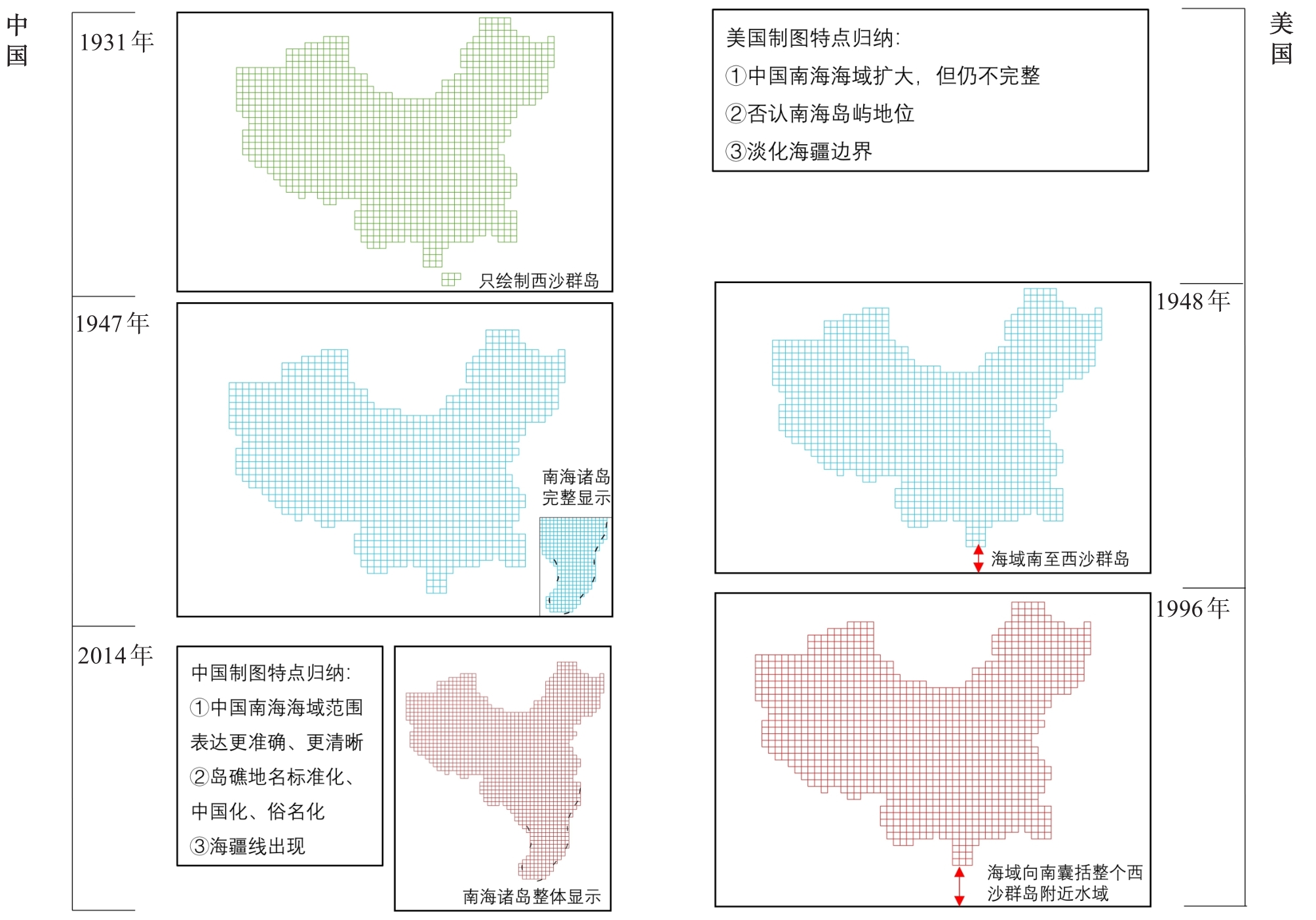
In recent years, frequent conflicts in the South Sea of China have hindered peaceful Chinese development processes. For the first time, this study used political geography and territory to examine the process of interplaying national cartographic practices and power relations in this space. Combined with a previous discussion on territory and cartography, this study proposed a national cartographic analysis framework from the territory and applied it to the cartography of the South Sea of China. First, we performed a longitudinal comparison of cartographic evolution in the South Sea of China between China and the United States. Then, a longitudinal comparison of expressions between China and the United States was performed for three aspects of cartographic practice. The longitudinal comparison showed that the evolution of South Sea of China cartography resulted in a more complete sea area, standardized island names, and a sea boundary line that appears in China. In the United States, the South Sea of China showed enlarged sea areas, but the overall picture was incomplete. According to the longitudinal comparison, the United States differs from China in the following three aspects of the cartography of the South Sea of China: sea area, status of islands and reefs, and sea boundaries. In summary, we can draw three conclusions. 1) In China and the United States, the cartographic evolution of the sea areas of the South Sea of China, the names of islands and reefs, and the expression of sea boundaries reflect the influence of the country's power. 2) The difference in the cartography of the South Sea of China between China and the United States stems from the need to safeguard the core interests of the country. China, through the territorialization of cartography, has strengthened the maritime jurisdiction of the South Sea of China, increased awareness of national sea rights internally, and declared the sovereignty of the South Sea of China externally. However, the United States has emphasized the public seas and multinational attributes of the South Sea of China through cartographic territorialization. 3) As a territorial tool, a map presents the Chinese story of the South Sea of China on the international stage and may also clearly express China's consistent and clear position on the sovereignty of the islands and surrounding waters of the South Sea of China. The territorial expression of the South Sea of China should be strengthened from the following three aspects: map rights protection, map innovation, and map publicity. Thus, cartography may play a more important role in the governance of China's maritime territory in the South Sea of China.
The shift of the global shipping network center to East Asia is a trend that has been widely recognized. As the main carrier of logistics and trade transportation in the RCEP and the surrounding areas of the South China Sea, research on the container port system and network structure in the surrounding areas is of great significance for understanding the characteristics and optimization of maritime trade channels in the surrounding countries and regions of the South China Sea. Based on route data from the world's top eight shipping companies, we selected 37 container ports around the South China Sea as the research objects of this study. First, we constructed a two-way network on their existing route distribution and studied their port system characteristics and network structure using complex network centrality indicators and network structure models, such as degree centrality, proximity centrality, intermediate centrality, and right index. The conclusions are as follows: (1) In recent years, the status of container ports in countries and regions along the South China Sea within the world container port system has generally been on the rise. The overall ranking of port throughput is relatively stable. The capacity of container ports in seven countries around the South China Sea is unevenly distributed, mainly in China and Singapore. (2) In terms of network centrality analysis, port routes, such as Shenzhen, Singapore, Hong Kong, Kaohsiung, Qingdao, and Shanghai, are abundant, and there are many regions that can conduct trade directly, which are less affected by other port connections. Shanghai, Shenzhen, Ningbo, Zhoushan, Guangzhou, and other ports play an important role as tandem intermediaries in international container routes and have a strong ability to control the shipping network. (3) In terms of network level, the port network status is divided into four levels according to the differentiation of port throughput scale and center degree. The first-tier ports are the home ports of international routes, including Shanghai, Singapore, Shenzhen, Ningbo Zhoushan, Guangzhou, Qingdao, and Hong Kong. Ports on the second layer are the hub ports of international routes, including Kaohsiung, Tanjung Pelepas, Xiamen, Tianjin, Laem Chabang, Klang, and Ho Chi Minh. This layer contains mostly the hub ports of international routes, with a good degree of central development. Ports on the third layer are the international route connecting ports, including Haiphong, Qinzhou, Dalian, Tanjung Priok, Manila, Tanjung Perak, Lianyungang, Cai Mep, Yantai, Yingkou, Rizhao, and Fuzhou. The relative centrality of ports on this layer is low, and the throughput is relatively limited. Layer four ports are regional feeder ports, including Jinzhou, Taicang, Taichung, Dongguan, Tangshan, Nanjing, Quanzhou, Nantong, Zhuhai, Jiaxing, and Haikou, which have become popular transshipment ports owing to their geographical characteristics. (4) In terms of network structure, the overall network can be divided into four port communities. Among them, community one has a clear central attribute, to which community two is closely connected, and community three is fed to the port group. Community four has clear small world attributes, and the port routes within this group are relatively independent.
This paper takes Hainan fishermen's Sea God belief as the research object, combines the archaeological discoveries of the South China Sea Islands, the local chronicles of Hainan Island and other documents, and the author's continuous field research data in Hainan from 2012 to 2020 and studies the Sea God belief pedigree and ritual activities of Hainan fishermen from the pedigree theory, using the methods of literature analysis and field investigation.The pedigree of the sea god family includes the sea water standard God, navigation protection God, fisherman professional (industry) God, sea god pilotage God, and others. These form the land-island-ship-spatial pedigree of immigrant societies in Southeast Asian countries; and the time pedigree of before going to sea-after returning home-before fishing-shipwreck-daily.These pedigrees have been incorporated in daily ritual activities in sea ceremonies in South China Sea Islands and daily practice. Based on the genealogical theory, the temporal and spatial genealogy of Hainan fishermen's belief and the social relations and order in ritual activities were analyzed, also by literature analysis and field investigation. The results showed that: 1) The captain has absolute authority. 2) Tradition that formed from those who first visit the island and worshiped the temple prioritized fishing. 3) Joint worship of gods is prominent, with the worship of 108 brothers being the most important and grand aspect of sacrificial ceremonies. 4) The local sea god belief of Hainan fishermen is an important symbol of identity and regional identity of overseas Chinese in Hainan.
In the context of globalization and mobility, mobility and home have become an important topic in the study of the new cultural geography. Previous studies on mobility and home have paid more attention to the impact of land-based mobility on the home, and less to mobility in the marine context and its connection with the home. From the perspective of mobility in the marine context, based on the home geography and the connotation of the home culture, this paper discusses the production space of fishermen during the long-term working the sea in three parts: the function, the emotion, and the imagination of the home. First, in the construction of the home, fishermen in Hainan fully realized the function of the home through the spatial design and material landscape of the fishing boat, satisfying their multi-sensory experience of a home. In terms of the space design of the fishing boat, its interior is equipped with living spaces and equipment such as lounges, kitchens, leisure rooms, refrigerators, TVs, and air conditioners. During the production time, these spaces and equipment can also be used to make up for their separation from the flow of the home, and through these advanced facilities, the "home function" of the fishing boat can be fully realized. Second, fishermen who live at sea far away from their families need not only the function of a home but also emotional support. Therefore, the deep collective feelings experienced by fishermen throughout their long-term life on fishing boats, the teaching of sailing skills from the old to the new fishermen, and their concern about their daily lives have reduced the feeling of distress and loneliness among the fishermen who have been away from home for a long time, giving them the emotional experience of a home. Finally, in terms of mobility, the fixed position and boundaries of the home have been gradually blurred, and the home has gradually been endowed with a broader scope and rich connotations and can be constructed through the imagination of individuals or groups. The experiences of fishermen in the production space in the South China Sea are not limited to the interior of the fishing boat. During their movement across the sea, they acquire a sense of familiarity based on their knowledge of a specific area of the South China Sea and generate an image of the surrounding environment. During their long-term life at sea, fishermen also experience a sense of familiarity and belonging to the natural environment at sea. Through familiarity with features such as place names, orientations, and shapes of the islands and reefs, as well as a keen awareness of the boundaries of the sea area, the South China Sea is gradually considered the homeland image of the "ancestral sea."
For a long time, the field of marine geography has been located at the edge of the discipline, strengthening the terrestrial bias of human geography. Fishermen, one of the few action actors in the ocean, have natural mobility characteristics. Existing research on fishermen pays more attention to the temporal and spatial regulations and distribution of their mobility than the social and cultural connotations generated in the process of their flow. From the perspective of mobility and collective memory, a typical fishing village in the east of Hainan Province was selected as a case study, and through participatory observation, semi-structured interviews, and text analysis, the construction of the local memory of fishermen in the process of mobility was comprehensively understood. In this study, the following points were found: First, according to research on the new paradigm of mobility, the world interact with each other through the flow of nodes and the space of flows, with emphasis on liquidity from the state of "flow, berthing, settled" in three different space-time conceptions to describe the world, thus inferring the Hainan fishermen's marine mobility, at least in the scope of time and space, material basis, and the paths of nodes. Second, collective memory is an important way for fishermen to interact with each other and construct emotions in the flow process. The core of this is fishing and hunting culture and the cross-border network. Three points should be made clear when discussing the collective memory of fishermen from the perspective of mobility: First, collective memory is essentially based on the "present" and a construction of the "past", and a change of subject will greatly affect the continuity and inheritance of memory. Second, memory is formed by personal emotions and objective environments. For fishermen, collective memory unfolds in a specific place, shifting with different spatial scales through a landscape of physical and symbolic memories. Third, geographical and social mobility complement each other, exacerbating the differences of fishermen and leading to the fragmentation or failing of collective memory. This paper makes two contributions to this concept: (1) Taking the phenomenon of the flow of fishermen as an example, the ocean is examined from the perspective of the ocean, emphasizing the importance of the connection between the ocean and land. It also goes beyond the land's perspective of the sea, indicating that the ocean is an equally important substrate for the integration of socio-cultural, political, and economic transformation processes and should not be regarded as a negative space of land. Instead, it is the center of the process of knowledge production, concrete experience, and understanding the transcendence of the present. (2) It responds to the attention of the new mobility paradigm to special space and compensates for the missing dimension of interaction between the marine environment and human activity.
To ensure maritime search and rescue safety, this study combined a geographic information system and a fuzzy analytic hierarchy process to map and evaluate the difficulties of maritime search and rescue in the South China Sea. To construct a maritime search and rescue difficulty index system, nine factors related to the natural environment and human power that may influence maritime search and rescue were selected, and difficulty indices were calculated according to the corresponding calculation method. The fuzzy analytic hierarchy process was then used to determine the weight of each index, and the linear weighting method was used to obtain the maritime search and rescue difficulty value of the South China Sea. The difficulty values were divided into 10 levels and the spatial distribution characteristics were analyzed. The results show that: 1) under the influence of the natural environment, the difficulty of search and rescue in the sea area of the South China Sea had the characteristics of a V-shaped distribution, and the difficulty level gradually decreased from northeast to southwest. 2) Under the influence of humanistic search and rescue forces, the overall difficulty of search and rescue in the study area was the "NE-SW belt" type. The area with high difficulty levels was mainly located on the line connecting the northeast to the southwest of the study area, and the difficulty decreased in an irregular circle on both sides of the connecting line. 3) Considering these two factors, the difficulty of search and rescue was relatively high around some islands in the South China Sea, because of the influence of severe weather events, such as typhoons, and their large distance from the search and rescue base. The difficulty values in the far seas have "NE-SW decreasing" spatial distribution pattern, with the highest values in the areas extending from the northeast to the southwest of the study area, then decreasing to the northwest and southeast. According to statistics, approximately 21.1% of the sea areas in the South China Sea have search and rescue difficulties greater than level 6, and the construction of search and rescue forces should be optimized accordingly.
To prevent and decrease the number of marine tourism safety accidents, Chinese marine tourism safety accidents were studied using a chi-square contingency table analysis, residual test, time intensity index, geographic concentration index, and imbalance index. Accordingly, suggestions for marine tourism safety management were proposed. The types, characteristics, timing, and spatial distribution laws of Chinese marine tourism accidents from 2010 to 2021 were analyzed. We obtained the following results. 1) The type of Chinese marine tourism safety accidents included drowning, being trapped, traffic accidents, suicide, accidental injuries, animal bites, disease outbreaks, fires, and food poisoning. 2) There were differences in the leading causes of different types of accidents. Thus, tourists with different individual characteristics may experience different types of accidents, and different tourist activities may cause different types of accidents. 3) Chinese marine tourism safety accidents showed differences in the type and frequency in different years, months, and times of day. On a large time scale (annual), the number of accidents showed an increasing trend. On a medium time scale (month), accidents occurred most frequently in July-August, May-June and October followed, whereas on a micro time scale (hour), accidents occurred most frequently in the afternoon (T 14:00-18:00), the morning (T 08:00-12:00), and the evening (T 18:00-21:00) followed. 4) Chinese marine tourism accidents were aggregated and imbalanced in marine tourism circles, cities, and points. The large spatial scale was concentrated in regions across the West coast of Fujian and Taiwan Strait and the Bohai Rim; the small spatial scale was concentrated in Xiamen, Quanzhou, and Fuzhou; and the micro spatial scale was concentrated in the nodes of the beach, reef, and sea. Based on these findings, the management of high-incidence accidents should focus on precise and efficient safety management based on the leading causes, individual characteristics, and activities of tourists involved in accidents. Moreover, safety prevention and supervision should be carried out at important time and space nodes according to the timing and spatial distribution laws of accidents.
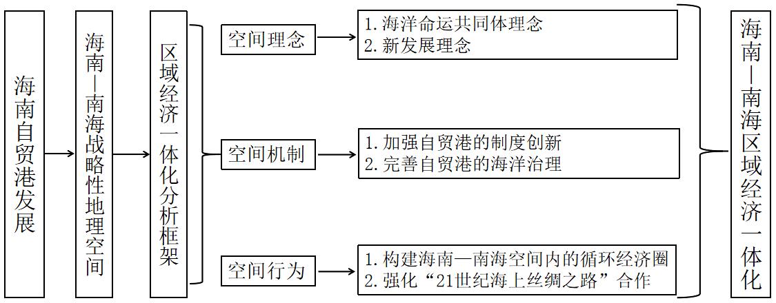
From the perspective of economic geography, the features, marine attributes, and offshore spatial characteristics of Hainan Island, as well as the special institutional arrangement of Hainan Free Trade Port, provide a new research perspective on the promotion of regional economic integration.Currently, the construction of Hainan Free Trade Port is in the key stage of building a new development pattern of domestic and international dual circulation.In its process of development, the free trade port is oriented to the ocean and to the world, contributing to a new economic geospatial pattern.Accordingly, a new concept of economic geography for Hainan and the South China Sea is put forth, and a new analytical framework is constructed, composed of spatial concept, spatial mechanism, and spatial behavior, to explore the path and prospects of the development of the Hainan Free Trade Port and promote the regional economic integration of Hainan and the South China Sea.The results indicate that the Hainan-South China Sea geospace is the spatial basis for the development of the Hainan Free Trade Port to promote regional economic integration.First, at the spatial concept level, the concept of marine community and the new development concept should be deeply implemented, and the cultural concept should be taken as the driving force to promote Hainan-South China Sea regional economic integration during port development.Second, at the spatial mechanism level, institutional innovation and marine governance of the Hainan Free Trade Port should be strengthened, and Hainan-South China Sea regional economic integration should be promoted with rules and systems as the driving force.At the spatial behavior level, a circular economy in Hainan-South China Sea should be built and the "21st Century Maritime Silk Road" should be consolidated with behavioral interests as the driving force to promote Hainan-South China Sea regional economic integration.Finally, regarding its contributions, in the face of international economic system transformation and trade protectionism, regional economic integration is crucial for China to build a world-class free trade port, integrate into economic globalization, and deeply participate in global economic governance.By putting forth the new economic and geographical concept of Hainan-South China Sea, and constructing a new analytical framework, it is of great theoretical and practical significance to grasp the internal logic, influence mechanisms, and practical path of development for Hainan Free Trade Port to promote the regional economic integration of Hainan-South China Sea.
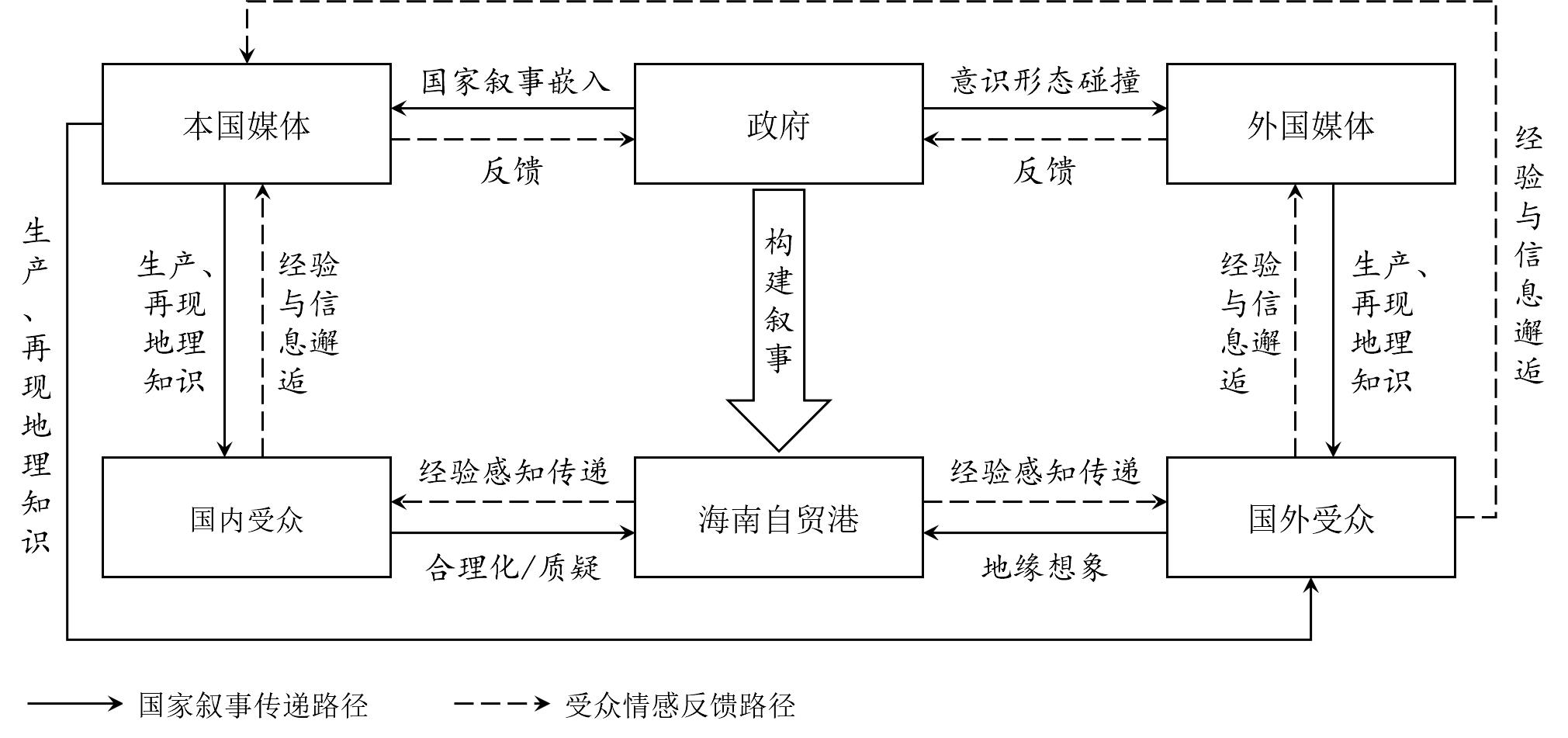
Currently, the world is undergoing profound changes, and the rise of counter-globalization and trade protectionism is impacting global economic governance. The development of globalization faces major challenges. In this context, China proposed building the Hainan Free Trade Port in 2018, which was understood as both a necessity for China to deepen reform and open up and as an effort to actively reshape the geopolitical and economic environment in global governance. Taking the Hainan Free Trade Port and its geopolitical meaning as the research object, this study employed discourse analysis and netnography to explore geopolitical practices based on nation branding, examine how actors such as the government, media, and domestic and foreign audiences participate in the (re)production of the geo-meaning of the Hainan Free Trade Port, and discuss its geopolitical operational mechanisms in depth. The findings indicated the following: (1) The Chinese government utilized media tools for knowledge representation and production, disseminated grand narratives for domestic and foreign audiences, and worked to build national identity, emphasizing China’s role as a builder under regional and global systems. The audiences were not exclusively passive recipients of media messages, but participated in processing and reproducing them. (2) For domestic audiences, the national narrative inspired some audiences’ national awareness and legitimized Hainan's free trade port. Meanwhile, top-down meaning-making generated contradictory results in specific contexts and even triggered critical, bottom-up debates. For foreign audiences, owing to the political and cultural differences between China and the West, media messages were processed secondarily as a source of geographical imagination, which in turn shaped audiences’ subjective perceptions of the international geopolitical landscape. (3) Finally, the media played an important role in the brand construction process as an information “bridge.” On the one hand, the media served as a tool for the top-down and inside-out transmission of national narratives, creating a favorable public opinion environment for Hainan Free Trade Port’s construction. On the other hand, the media served as a medium for bottom-up and outside-in feedback of audience emotions. Nevertheless, it should be emphasized that the delivery and feedback paths still need to be negotiated for a positive nation branding operation. The contribution of this research is reflected in two aspects: Through the theoretical introduction and case analysis of the geopolitical meaning of nation branding, it provides an initial exploration of related research in China; and, in the context of China’s participation in global governance, it provides a realistic reference for the steady progress of the Hainan Free Trade Port.
Hainan is entitled to govern the waters and islands claimed by China in the South China Sea and is surrounded by the sea and nine Southeast Asian countries. Hainan plays an extremely special role in the systematic building of a maritime community with a shared future between China and ASEAN countries. Although the roles of Hainan in the implementation of such a maritime community are not decided, the present study clearly discusses the concept of a maritime community with a shared future from multiple perspectives, and provides a framework for Hainan's role in the community. Hainan has a three dimensional role in the systematic cooperation between China and Southeast countries to build a maritime community: a forward base, an important strategic fulcrum, and a pioneer officer. The special policy advantages of building a free trade port with Chinese characteristics will provide impetus for Hainan to transform these advantages into practical effects. However, objective factors such as the South China Sea disputes, the small scale of the Hainan marine industry, and deficiency of marine research capability have caused a "containment effect" to some extent. This paper argues that Hainan can optimize its spatial and industrial layout by scientifically planning the development of marine industry, relying on the top-level design of the government and guided by the special policy arrangements of free trade port with Chinese characteristics, in order to cope with the challenges posed by politics and relatively lagging development. Certainly, two aspects still need to be further discussed: Hainan overcoming the effects of maritime disputes, and competing for leadership in the renewal of the regional marine industrial system.
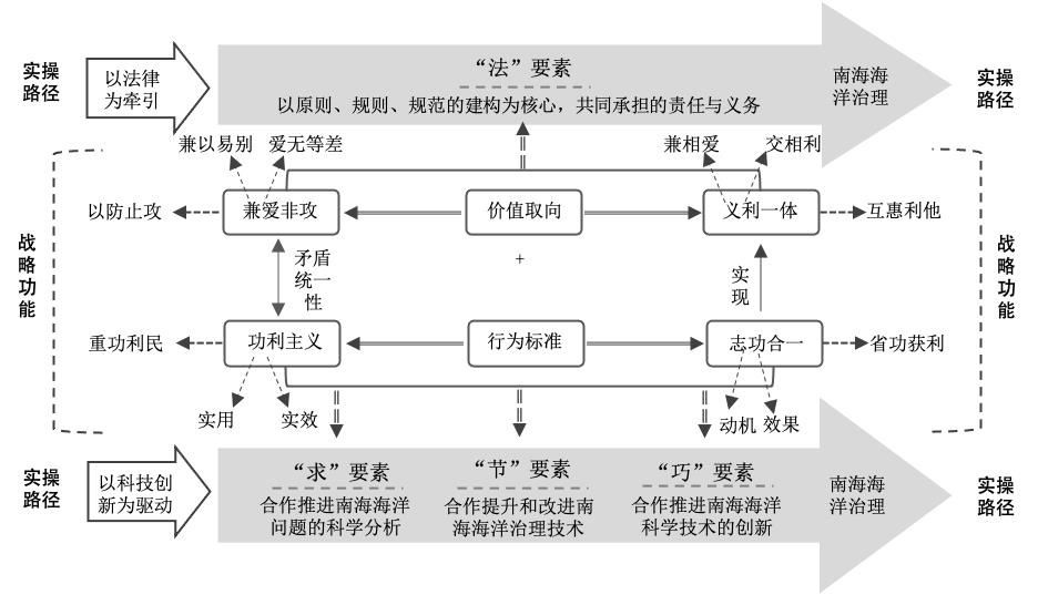
The fluidity of the ocean makes maritime governance both a local and global issue. Effective maritime governance in the South China Sea needs to be guided by the principles of new international relations and the maritime community of a shared future, take a different path from traditional Western geopolitical ideas, and fully integrate the wisdom of Chinese philosophy. Based on the perspective of the integration of Chinese philosophy and geopolitics, we deconstructed the issue of maritime governance in the South China Sea from the perspective of geopolitics, elaborated and extracted the key points of Mohist philosophy for maritime governance in the South China Sea, and built a geopolitical strategic system of maritime governance in the South China Sea based on Mohist philosophy embedded in new international relations. The main conclusions were as follows: (1) the unclear governance objectives within the region, the failure of governance guarantees, the intervention of foreign powers, and the limited role of international organizations has resulted in a dilemma regarding maritime governance in the South China Sea. (2) The South China Sea Ocean Governance takes the unity of the natural ocean and the human ocean as the governance objects and sovereign states as the main actors. (3) One core point, three guiding principles, and four key elements were extracted from Mohist philosophy and applied to the maritime governance of the South China Sea. On the basis of this concept, we should consider "love non-aggression" and "integration of justice and benefit" as the value orientations, and "utilitarianism" and "unity of ambition and work" as the standards of behavior. From a practical standpoint, we should embed the "law" elements of Mohist philosophy; take law as the traction; and embed the "seeking", "saving", and "skillful" elements of Mohist philosophy, driven by scientific and technological innovation.
In 2012, with the claimant countries of the South China Sea dispute stepping up their occupation of marine resources and the deep involvement of foreign powers in the South China Sea issue, the surrounding maritime situation became increasingly complex and there were multiple conflicts of interest caused by the continuous erosion of China's maritime rights. In order to effectively exercise sovereign rights and jurisdiction over the exclusive economic zones and continental shelf in various sea areas, including the South China Sea, and shape a peaceful and stable maritime security environment, China has launched a national maritime strategy with the theme of "building maritime power." Current research on the building of maritime power has paid greater attention to the concept analysis, development goals, and implementation path of maritime power, mainly focusing on the "ought" aspect of maritime power, with little attention to the "actual" aspect. Based on the attention analysis framework of leaders in attention politics, this study analyzes the launch and implementation of the national marine strategy of building maritime power after 2012 and explains the mechanism of building maritime power. Given this background, this research shows the following: (1) The limited attention of leaders and governments is the mediating variable between changes in the international system structure and the generation of state behavior. (2) Changes in the international situation, local government competition, emergency stimulation, and previous political experience are the trigger factors for building maritime power, causing the attention of leaders and governments to shift. (3) Leaders promote policy implementation through speeches, instructions, inspections, and other activities, which are the basis for measuring the attention of leaders and governments for building a maritime power. Research on the mechanism of building a maritime power shows: (1) Following the reconfiguration of the national maritime strategy, the attention of the leaders and governments continues to play a role in the implementation process of the new maritime strategy. (2) Leaders accelerate the operation of maritime strategies through their own activities such as inspections and instructions. (3) Building maritime power has been promoted to a high level through the establishment of high-level institutions. (4) Public and social attention should be fixed through the continuous agenda-setting of maritime affairs by the state media. This mechanism has effectively guided and locked the focus of China's attention on maritime affairs, thus effectively reshaping the traditional strategic culture and social cognition that China values land over the sea.